NOAA Updates its ENSO Alert on August 8, 2024 – We Remain in ENSO Neutral – Published August 9, 2024

“Synopsis:  ENSO-neutral is expected to continue for the next several months, with La Niña favored to emerge during September-November (66% chance) and persist through the Northern Hemisphere winter 2024-25 (74% chance during November-January).”  

So we are really in ENSO Neutral but NOAA may not want to admit their forecast was wrong so they present it as waiting for La Nina. It is correct that we are in La Nina Watch but it is also correct that we currently remain in ENSO Neutral.

On the second Thursday of every month, NOAA (really their Climate Prediction Center CPC) issues its analysis of the status of ENSO. This includes determining the Alert System Status.  NOAA now describes their conclusion as “ENSO Alert System Status: La Nino Watch”

The exact timing of the transition is now less clear which should decrease the reliability of the Seasonal Outlook to be issued next Thursday.

We have included an ENSO Blog article by Tom Di  Liberto.

 >

CLIMATE PREDICTION CENTER ENSO DISCUSSION (LINK)

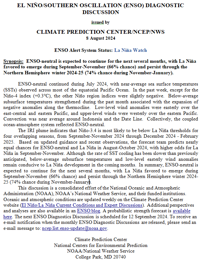
The second paragraph is what is important:

“The IRI plume indicates that Niño-3.4 is most likely to be below La Niña thresholds for four overlapping seasons, from September-November 2024 through December 2024 – February 2025.  Based on updated guidance and recent observations, the forecast team predicts nearly equal chances for ENSO-neutral and La Niña in August-October 2024, with higher odds for La Niña in September-November. Although the rate of SST cooling has been slower than previously anticipated, below-average subsurface temperatures and low-level easterly wind anomalies remain conducive to La Niña development in the coming months.  In summary, ENSO-neutral is expected to continue for the next several months, with La Niña favored to emerge during September-November (66% chance) and persist through the Northern Hemisphere winter 2024-25 (74% chance during November-January).”

Below is the middle paragraph from the discussion last month.

“Compared to the previous month, the most recent IRI plume delayed the emergence of La Niña to September-November 2024, with La Niña then persisting through the Northern Hemisphere winter.  The forecast team is also favoring a delayed development of La Niña this month, but is anticipating the transition to occur earlier (August-October).  This is, in part, supported by the continuation of below-average subsurface ocean temperatures and near-term forecasts suggesting a resurgence of easterly wind anomalies in July.  In summary, ENSO-neutral is expected to continue for the next several months, with La Niña favored to emerge during August-October (70% chance) and persist into the Northern Hemisphere winter 2024-25 (79% chance during November-January).”

We now provide additional details.

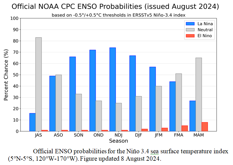
CPC Probability Distribution

Here are the new forecast probabilities. The probabilities are for three-month periods e.g. JAS stands for July/August/September.

Here is the forecast from last month.

The analysis this month and last month are a bit different with again the transition to La Nina being slower than thought last month. This seems to be a trend. The chart is clearer than the discussion in the summary report above.  The La Nina is slower to arrive and is projected to last perhaps one month less than previously forecast. I am not sure that we will actually have a La Nina.

Some will need to click on “Read More” to read the rest of this article.

Is ENSO running a fever, or is it global warming? December 16, 2023

Is there a need to improve how we forecast ENSO?

First I have to describe what ENSO is.  It is going to be a short definition of a very complex topic.

There appears to be a pattern that some incorrectly call a fixed cycle (rather than more of an oscillation) where sometimes the warmest water along the Equator in the Pacific Ocean is found to the west (officially the IndoPacific Warm Pool) and sometimes it is found to the east (leading to the name El Niño). When it is to the west we call that a potential La Nina. When it is to the East we call that a potential El Nino. And when it is not clearly to the west or the east we call it ENSO Neutral.

I am not in this article going to explain why the warm water is sometimes to the east or why it is sometimes to the east. It is very complicated.

Why is it important?

Generally speaking, warmer water evaporates more easily than cooler water. Where ocean water evaporates, clouds form. This rising of moisture to form clouds creates a circulation pattern called the Walker Circulation with rising air forming clouds and due to circulation patterns in other places there is precipitation and the air sinks.

Through other mechanisms that I will not describe in this article, the precipitation also spreads north and south of the Equator to impact weather patterns in the mid-latitudes all around the world.

What is the problem?

One problem is that the rising and subsiding process does not always materialize or match where we detect the warmer than normal water and the cooler than normal water. If it does not materialize, the changing distribution of the warmer and cooler water has little or no impact on the atmosphere and hence on weather. Thus the potential El Nino or La Nina does not become a true El Nino or La Nina. If it does materialize but not where we predict it would, that creates a El Nino or La Nina with different impacts than usual.

How to measure the process.

This is described in this article which is really a two-year-old ENSO Blog Post. I  have included it in its entirety other than comments made to the article.

Short Abstract

The traditional way of measuring the distribution of warm and cool water is to do measurements in certain areas in the Eastern Pacific and consider the surface temperature relative to history. If the temperature of the surface area in the selected area is equal to or more than 0.5C above normal, it is potentially an El Nino.  If it is -0.5C or cooler it is potentially a La Nina.

Where is the problem?

The potential problem is that ocean surface temperatures are warming. So is the threshold of 0.5C above or below normal as meaningful as it has been in the past?

What is the solution?

The traditional solution has been to revise the definition of normal periodically.

What is this ENSO Blog Post about?

Is the traditional approach adequate or would recalculating the temperature anomaly to consider the overall level of ocean warming or the ocean warming nearby improve the ability of the formula to predict weather that is more consistent with the assessment of El Nino and La Nina periods? This means using what is called a Relative Oceanic ENSO Index instead of the Regular Oceanic ENSO Index.

I will now let the ENSO Blog Post explain this. I do not think the described method has been implemented or at least not officially. One reason for that might be that it is an improvement but does not fully address the complications that warming oceans cause to our ability to measure and anticipate the impacts of the ENSO process; a process which may gradually change dramatically. This is the start of a much more complicated discussion but it is a good start.

Is ENSO running a fever, or is it global warming?