Our Report on the JAMSTEC Three-Season Forecast – Posted on January 17, 2024

The Japan Agency for Marine-Earth Science and Technology, or JAMSTEC, is a Japanese national research institute for marine-earth science and technology

From the JAMSTEC Discussion:

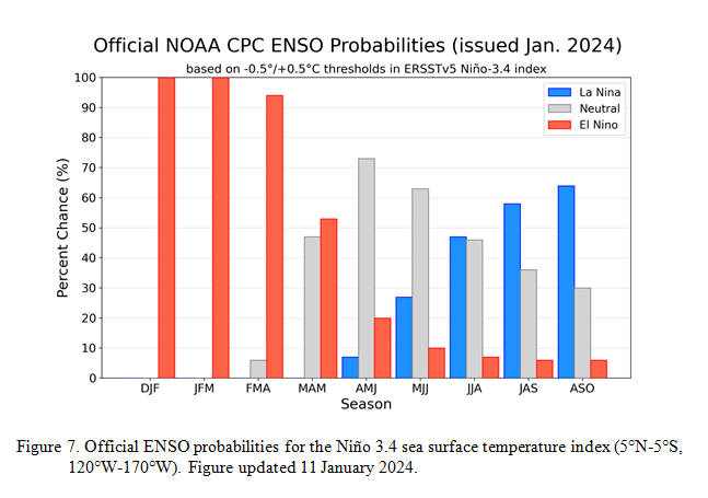
“The recent observation suggests that the El Niño reached its peak. The SINTEX-F ensemble mean predicts that the El Niño will decay and an El Niño Modoki will develop and persist at least until the next boreal spring. The model also predicts that a La Niña Modoki will occur in boreal autumn. However, there is a large uncertainty in the predicted amplitude.”

Although it is a World forecast, it includes a forecast for North America since North America is part of the World.

First, we take a look at the forecasted sea surface temperature anomalies (SSTA). JAMSTEC starts by forecasting the SSTA and Nino 3.4 Index on the first day of the month and from there it usually takes their models about two weeks to produce their seasonal forecast. I received it from JAMSTEC on January 10, 2024 which is a week before when NOAA will issue their Seasonal Update this month but I had so many articles to publish that I did not publish this JAMSTEC forecast immediately.  The JAMSTEC model runs are based on conditions as of January 1, 2024. The NOAA Seasonal Outlook will be based on conditions closer to the time when it is issued.

We have a full three-season forecast from JAMSTEC this month. We also have single-month forecasts for February, March and April 2024.

Let’s take a look.


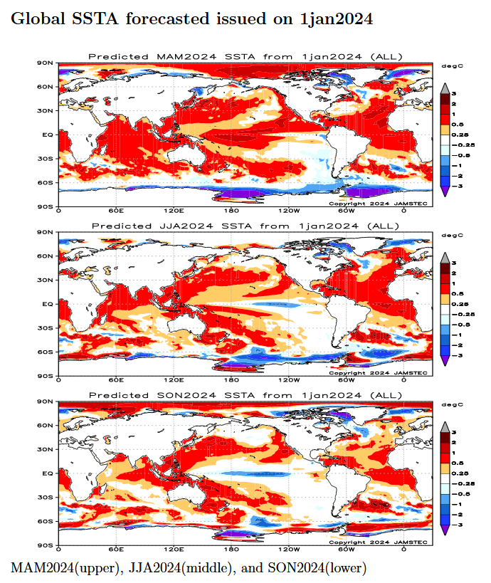
This shows their forecast of sea surface temperature anomalies at three points in time. Red is warm and is associated with El Nino if it occurs in the Nino 3.4 measurement areas.  You can see the El Nino tongue of warm water extending from Peru to the west in the MAM image but look at that blob of warm water to the west i.e. by this point in time this has Modoki characteristics which impact the Walker circulation. JJA and SON show ENSO Neutral or La Nina.

JAMSTEC (and also NOAA) are showing very warm oceans in many parts of the world.  I have written about that before. It raises questions about the reliability of our current approach to thinking about the ENSO Cycle. This is covered in another article that can be accessed HERE. But JAMSTEC is showing a relatively normal ocean off the coast of much of the U.S. which probably explains their strange forecast.

JAMSTEC uses the same definition of Normal (climatology) as NOAA. JAMSTEC does a better job at characterizing La Ninas and El Ninos than NOAA. JAMSTEC provides me with a lot of other information that I do not include in my articles to keep them to a manageable size for readers.

JAMSTEC has been having some computational issues with its model. From the email I received from them: “Because of changes to the library in our computer, this time we could not complete all members”. Last month they were not able to publish at all. I do not know how to assess their message to me. In November they upgraded their model from 12 members to 36. Their goal is to go to 108. On the website, the images indicate that all members were included. It is not possible to accurately estimate the current conditions. So the technique in ensemble models is to perturb the assumptions slightly for multiple model runs (or use different physics models for some runs) and take the average (mean) of the solutions. Each solution is called a member of the group of solutions for which the mean was taken.  I am intrigued by the coincidence of this “change to the library in our computer” with their publication of this article. Based on the Japanese Culture they would not have released this forecast if they did not have confidence in it.

Some Readers will have to click on “Read More” to read the rest of the article which you need to read to see the forecasts. I can only include a certain amount of material in the lede.

NOAA Updates its ENSO Alert on January 11, 2024 – The El Nino Advisory Continues. Disagreement on When it Will End

On the second Thursday of every month, NOAA (really their Climate Prediction Center CPC) issues its analysis of the status of ENSO. This includes determining the Alert System Status.  NOAA again describes their conclusion as “ENSO Alert System Status: El Nino Advisory”

There is not much doubt that we have an El Nino. How long it lasts and its strength remains to be seen.  This El Nino has not become a Historical El Nino. We will try to address the slight confusion of when the El Nino will end in this article.

We have included some very interesting graphics from and a link to an interesting ENSO Blog article by Emily Becker.

CLIMATE PREDICTION CENTER ENSO DISCUSSION

The second paragraph is what is important:

“The most recent IRI plume indicates El Niño will gradually weaken and then transition to ENSO-neutral during spring 2024 .  Some state-of the-art dynamical climate models suggest a transition to ENSO-neutral as soon as March-May 2024.  The forecast team, however, delays this timing and strongly favors a transition to ENSO-neutral in April-June 2024.  There are also increasing odds of La Niña in the seasons following a shift to ENSO-neutral.  It is typical for El Niño to peak in December/early January, but despite weakening, its impacts on the United States could last through April (see CPC seasonal outlooks for probabilities of temperature and precipitation).  In summary, El Niño is expected to continue for the next several seasons, with ENSO-neutral favored during April-June 2024 (73% chance).

Below is the middle paragraph from the discussion last month.

” The most recent IRI plume favors El Niño to continue through the Northern Hemisphere winter 2023-24.  Based on the latest forecasts, there is now a 54% chance of a “historically strong” El Niño during the November-January season (³ 2.0°C in Niño-3.4).  An event of this strength would potentially be in the top 5 of El Niño events since 1950.  While stronger El Niño events increase the likelihood of El Niño-related climate anomalies, it does not imply expected impacts will emerge in all locations or be of strong intensity (see CPC seasonal outlooks for probabilities of temperature and precipitation).  In summary, El Niño is expected to continue through the Northern Hemisphere winter, with a transition to ENSO-neutral favored during April-June 2024 (60% chance;).”

We now provide additional detail.  The level of uncertainty with respect to how this El Nino will play out has increased quite a bit.

CPC Probability Distribution

Here are the new forecast probabilities. The probabilities are for three-month periods e.g. DJF stands for December/January/February.

Here is the current release of the probabilities:

This chart shows the forecasted progression of the evolution of ENSO from the current El Nino State to Neutral and by the summer to La Nina.

Here is the forecast from late last month.

The analysis this month and last month are different.  This month the probability of El Nino in MAM is much less than was expected last month.  That is important.

Our Report on the JAMSTEC Three-Season Forecast – May 15, 2023

The Japan Agency for Marine-Earth Science and Technology, or JAMSTEC, is a Japanese national research institute for marine-earth science and technology

From the JAMSTEC Discussion:

“Observation shows that the La Niña Modoki-like state persists. The SINTEX-F ensemble mean predicts that an El Niño will occur in June. However, there is a large uncertainty in the predictions of the amplitude, and the ensemble mean of the SINTEX-F2-3DVAR version predicts a relatively weak El Niño.” [This puts JAMSTEC in disagreement with NOAA and most other Meteorological Agencies]

Although it is a World forecast, it includes a forecast for North America since North America is part of the World.

JAMSTEC Issues their Three-Season World Forecast based on August 1 ENSO Conditions.

Usually, I compare the JAMSTEC forecast with the NOAA forecast after NOAA Issues its Seasonal Outlook. But this month, JAMSTEC was very early so I thought I would share it with everyone early. But I did not get around to doing it until now. NOAA calls their predictions an outlook but JAMSTEC calls their predictions a forecast. I am going to show the JAMSTEC forecasts by month and by season and some of the indices they use in their model. They make world forecasts and for any readers who do not realize it, the U.S. is part of the world so it is covered by a world forecast.

I like the JAMSTEC forecast because the U.S. is part of the world and our weather is not independent of the worldwide weather pattern. In fact, most of U.S. weather originates in the Pacific Ocean and the Pacific Ocean is where Japan is located. In fact, Japan and the US jointly manage the monitoring system along the Equator that helps predict the phases of ENSO. So one of the reasons I include worldwide forecasts in articles is to encourage the understanding of worldwide weather patterns. It is not that the U.S. does not cooperate with other nations with respect to weather forecasts as it does. But to view weather forecasts on the Internet or TV you would not easily notice that. The U.S. media pays hardly any attention to what other meteorological agencies predict.

JAMSTEC Seasonal Outlook for Spring and Summer of 2022

I should have reported this a couple of weeks ago after NOAA issued their Seasonal Outlook.  JAMSTEC is a well respected Japanese Research Agency for Marine-Earth Science and Technology. They have a proprietary forecast model and every month they normally issue a three-season forecast. This month they only looked out two seasons.  I think it is useful to look at more than one forecast as it provides to some extent an assessment of the variability one might expect in the observed weather compared to the forecasts. This is usually due to slight differences in the strength and timing of the ENSO Cycle. As discussed in this article, both NOAA and JAMSTEC may be working with assumptions about the ENSO cycle that may turn out to be incorrect. So this may limit our ability to forecast even as far out as this summer.