NOAA Updates its Four Season Outlook on August 17, 2023
On the third Thursday of the month right on schedule NOAA issued their updated Seasonal Outlook which I describe as their Four-Season Outlook because it extends a bit more than one year into the future. The information released also included the Mid-Month Outlook for the following month plus the weather and drought outlook for the next three months. I present the information issued by NOAA and try to add context to it. It is quite a challenge for NOAA to address the subsequent month, the subsequent three-month period as well as the twelve successive three-month periods for a year or a bit more. A seasonal drought outlook is also issued.
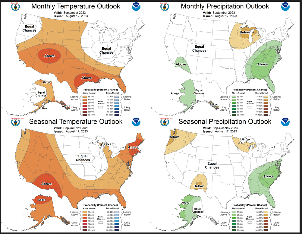
Take a look at September and the three-month period that includes September. The first row in this graphic is the Mid-Month forecast for September. The bottom row shows the outlook for the next three months including September.
The full NOAA Seasonal Outlook extends through August/September/October of 2024. All the maps are in the body of the article.
NOAA provides an excellent discussion to support the maps and the changes (which are minimal) from what was issued a month ago. It is best to read the full discussion but here are some of the highlights:
Re ENSO:
- The median North American Multi-Model Ensemble (NMME) consolidation forecast exceeds +1.5 degrees C at its peak in late autumn and early winter before decreasing at longer leads with greater uncertainty.
- The CPC consensus ENSO outlook indicates greater than a 90 percent chance that El Niño will continue through winter, with greater than a 60 percent chance that the strength of the Niño 3.4 anomaly will exceed +1.5 degrees C at its peak.
[Editor’s Note: How do we define the strength of El Nino? It is very informal but over 1.0 is considered moderate versus weak, over 1.5 is considered strong and over 2.0 is considered very strong.) It is a logical approach since the warmer the temperature anomaly the more we expect the Walker Circulation to be impacted. But it does not work out that way in all cases for all areas and some think the rate of change of the Nino 3.4 reading is also very important]
For September:
- Above normal temperatures are favored for most of the western CONUS, consistent with anomalous ridging.
- The strongest probabilities (greater than 50 percent) of above-normal temperatures are indicated near the Four Corners region.
- However, probabilities of warmer than normal conditions are tempered across much of the northwestern CONUS for the weeks 3-4 period, which includes most of the first half of September. [Editors’ Note: Remember this Outlook was issued on August 17 so three to four weeks from then is early September]
- Farther to the south and east, enhanced above-normal temperature probabilities are indicated across the Southern Plains, Lower Mississippi Valley, and parts of the Southeast.
- Equal chances (EC) of above, near, and below normal temperatures are indicated for the remainder of the eastern CONUS.
- Above-normal temperatures are favored for southern, eastern, and northern Alaska.
- Above-normal precipitation is favored across the Southeast northward to the Mid-Atlantic and westward to parts of the Tennessee and Ohio Valleys
- Conversely, below-normal precipitation is favored farther to the north and west for the western Great Lakes and Upper Mississippi Valley
- Latest weeks 3-4 guidance from the ECMWF and GEFS depict a wet signal across the Baja Peninsula and the Gulf of California, suggestive of potential tropical cyclone (TC) activity. This potential TC activity leads to a slight tilt toward above-normal precipitation for parts of the southwestern CONUS.
- Farther to the north, above-normal precipitation is favored for western Alaska
- A weak tilt toward below-normal precipitation is indicated for Southeast Alaska due to weeks 3-4 guidance
For SON 2023
- Above-normal temperatures are favored across Alaska and the western CONUS in the SON and OND 2024 temperature outlooks.
- The greatest probabilities exceed 50 percent for northern Alaska and parts of the Southwest, due to decadal trends.
- Above-normal temperatures are also favored eastward across the southern Contiguous United States (CONUS) into the Southeast and northward through the eastern CONUS into the eastern Great Lakes region, consistent with the consolidation of tools.
- Decadal trends lead to higher probabilities of above-normal temperatures over the Northeast.
- Potential El Niño impacts for the SON and OND seasons include cooler temperatures over much of the central CONUS, leading to weaker probabilities for above-normal temperatures
- During SON 2023, above-normal precipitation is favored for western and northern Alaska and the southeastern CONUS,
- Below-normal precipitation is favored for the Pacific Northwest, a small area of the Southwest, and the western Great Lakes region.
- Enhanced probabilities of above-normal precipitation for parts of Alaska are supported by dynamical and statistical tools.
- Below-normal precipitation for the Pacific Northwest and Great Lakes and above-normal precipitation for the Southeast are consistent with El Niño impacts, and largely persist through the next several leads.
- Below-normal precipitation for parts of the Southwest in the SON season is consistent with the persistence of a weaker-than-normal Southwest monsoon, while the outlook for the month of September favors above-normal precipitation in areas of southern California, Nevada and Arizona to the west due to shorter-term moisture flow from the East Pacific.
Beyond SON 2023:
- From the NDJ 2023-24 to the FMA 2024 seasons, as the leads extend through autumn into winter, increasing probabilities of above-normal temperatures are forecast from the Pacific Northwest across the northern tier of the CONUS into the Midwest and Northeast, consistent with increasing impacts of a strengthening El Niño.
- Equal chances of above, near, and below normal temperatures (EC) is forecast across the southern tier of the CONUS with a tendency towards cooler temperatures arising from El Niño impacts.
- For MAM 2024 and longer leads through SON 2024, the outlooks relied heavily on the ENSO-OCN tool, and decadal trends provide most of the available climate signals.
- The seasonal temperature outlooks evolve toward a similar pattern at the longest leads (MAM 2024 through SON 2024), and the forecasts generally depict a u-shaped pattern of enhanced probabilities of above-normal temperatures over the CONUS, and EC in the northern central CONUS into the central Mississippi valley.
- Below-normal precipitation is forecast across much of the northern tier of the CONUS from parts of the Pacific Northwest to the Great Lakes region from NDJ 2023-24 to FMA 2024, due to the expected strengthening El Niño.
- The enhanced probabilities of above-normal precipitation for the Southeast increase and extend westward incrementally across the Southern Plains into the Southwest for these leads, also consistent with a strengthening El Niño.
- For the MAM 2024 season and longer leads, areas of above- and below-normal precipitation coincide with signals due to decadal trends, including enhanced probabilities for below-normal precipitation in areas of the northwestern CONUS and enhanced probabilities for above-normal precipitation in the lower Mississippi Valley and Mid-Atlantic region.
