NOAA Updates its Mid-month Outlook for July, 2024 – Did they Get it Right this Time? – Posted on July 1, 2024

At the end of every month, NOAA updates its Outlook for the following month which in this case is July of 2024. We are reporting on that tonight.

There have been some significant changes in the Outlook for July and these are addressed in the NOAA Discussion so it is well worth reading.  We provided the prior Mid-Month Outlook for July for comparison. It is easy to see the substantial changes in the weather outlook by comparing the Mid-Month and Updated Maps.

The article includes the Drought Outlook for July. NOAA also adjusted the previously issued Seasonal (JAS) Drought Outlook to reflect the changes in the July Drought Outlook. We also provide the Week 2/3 Tropical Outlook for the World.

The best way to understand the updated outlook for July is to view the maps and read the NOAA discussion. I have highlighted the key statements in the NOAA Discussion.

I am going to start with graphics that show the updated Outlook for July and the Mid-Month Outlook for July. This is followed by a graphic that shows both the Updated Outlook for July and the previously issued three-month outlook for JAS 2024. So you get the full picture in three graphics.

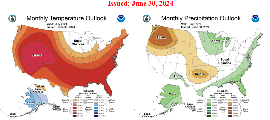
Here is the updated Outlook for July 2024.


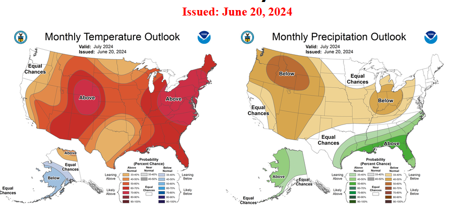
For Comparison Purposes, Here is the earlier Mid-Month Outlook for July.

It is important to remember that the maps show deviations from the current definition of normal which is the period 1991 through 2020.  So this is not a forecast of the absolute value of temperature or precipitation but the change from what is defined as normal or to use the technical term climatology.

It is a substantial change from what was issued on June 20, 2024. Remember, it is the first set of maps that are the current outlook for July.  One expects some changes  10 days later. However, the changes to the updated July Outlook are significant.  This then gives us some reason to question the (June 20, 2024) three-month JAS temperature and precipitation Outlooks which are shown in the following graphic.

NOAA provided a combination of the Updated Outlook for July and the Three-Month Outlook.

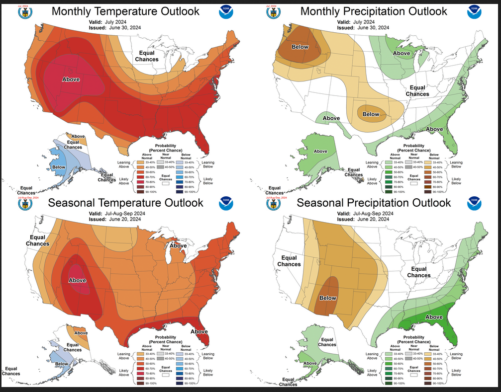
The top pair of maps are again the Updated Outlook for the new month. There is a temperature map and a precipitation map. The bottom row shows the three-month outlooks which includes July the new month. I think the outlook maps are self-explanatory.

To the extent that one can rely on a forecast, we would conclude that August and September will be very different than July, especially for precipitation. You can subtract July from the three-month Outlook and divide by two to get a combined August-September Outlook.

However given the major change in the new July outlook from what was issued on June 20,  2024, we might not trust the Seasonal Outlook issued on June 20, 2024. Something to think about.

Some readers may need to click “Read More” to read the rest of the article.  Some will feel that they have enough information. But there is a lot more information in the rest of this article.

NOAA Updates It’s July 2023 Outlook on June 30, 2023- It is a dramatic change from the Mid-Month Outlook

At the end of every month, NOAA updates its Outlook for the following month which in this case is July of 2023. We are reporting on that tonight.

There have been some significant changes in the Outlook for July and these are addressed in the NOAA Discussion so it is well worth reading. We highlighted some of the important statements within the NOAA Discussion. We also provided the prior Mid-Month Outlook for July for comparison.  From the NOAA Discussion:

  • El Niño is still present in the equatorial Pacific, and likely to remain in place for the entire month.
  • For the temperature outlook, the largest changes from the mid-month outlook to the updated outlook extend from the Northern and Central Rockies to High Plains, and across southern Alaska.
  • The outlook over the Northern and Central Rockies and High Plains now favors below-normal temperatures, largely influenced by the forecast conditions early in the month (Days 1-14).
  • The probabilities for above-normal temperatures are decreased over the Mississippi and Ohio River Valleys, reflective of the latest official outlooks and model guidance.
  • The precipitation outlook for Alaska has changed to favoring above-normal precipitation from the Alaska Peninsula northward across western Alaska to the Brooks Ranges and along the northern coast.
  • Hurricane Beatriz could trigger a monsoon moisture surge during the first half of July across the Southwest, so probabilities are mitigated compared to some model guidance.
  • Stronger signals  for above-normal precipitation are located over the Central Great Plains and Middle Mississippi Valley due to predicted rains in the first week exceeding the threshold for the below normal category on the monthly timescale.
  • Small portions of Texas are also likely to exceed that threshold during the first week of July.
  • During the remainder of the month, an active storm track is forecast from the Northern Rockies to the Ohio Valley and Northeast, which leads to enhanced probabilities of above-normal precipitation in those regions.
  • During July, a pattern change favors widespread above-normal rainfall extending from the central Plains across the Corn Belt and Northeast, with enhanced rainfall possibly extending southward to the southern Appalachians and Piedmont.

It may be easier to just look at the maps than digest the above.

The article includes the Drought Outlook for July. NOAA also adjusted the previously issued Seasonal Drought Outlook to reflect the changes in the July Outlook. We have also included the current fire incidents (dramatically decreased) and four months of Wildland Fire Potential Outlooks and also a map showingthe water-year-to-date precipitation. We also provide the Week 2/3 Tropical Outlook for the World.