Is Global Warming Impacting the ENSO Cycle – August 5, 2023

Is Global Warming impacting the ENSO Cycle? A friend of mine posted an interesting post on this on Climate.Gov and I think it is worth discussing. But we really do not have the ability at this point in time to know if this is happening and if so why.
This introduces the ENSO BLOG post on Climate.gov. Here is the link to the full post.

He provides two pieces of evidence. This is the one that resonated with me.

Presumably, we see higher highs (El Nino) and lower lows (La Nina) since 1960.  We do not seem to see higher highs and higher lows which one might expect with warmer oceans but all the values are anomalies that complicate things a lot. Actually, I am not 100% sure of exactly what this data represents. Presumably, it is the 5-month running mean minus the 1981- 2010 climatology. That is slightly different than the usual calculation of the value of the Nino 3.4 Index but it is challenging to compare current values to historical values as the temperature of the ocean surface increases.  I will copy Mike McPhaden and ask him if I have described the above correctly – stay tuned.  Trying to understand the impact of Global Warming is not simple.

The Footnotes to the post provide useful information

NOAA Updates its ENSO Alert on July 13, 2023 – El Nino is here and 90% Likely to Last through Winter with a 20% Chance of a MegaNino

On the second Thursday of every month, NOAA issues its analysis of the status of ENSO. This includes determining the Alert System Status.  NOAA again describes their Report as “ENSO Alert System Status: El Nino Watch”

There is not much doubt that we have an El Nino. How long it lasts and its strength remains to be seen.

From the NOAA Analysis:

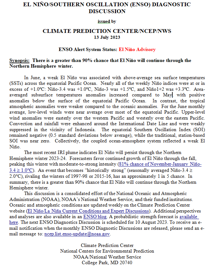
CLIMATE PREDICTION CENTER ENSO DISCUSSION

The second paragraph is what is important:

“The most recent IRI plume indicates El Niño will persist through the Northern Hemisphere winter 2023-24.  Forecasters favor continued growth of El Niño through the fall, peaking this winter with moderate-to-strong intensity (81% chance of November-January Niño-3.4 ≥1.0C).  An event that becomes “historically strong” (seasonally averaged Niño-3.4 ≥ 2.0C), rivaling the winters of 1997-98 or 2015-16, has an approximately 1 in 5 chance.  In summary, there is a greater than 90% chance that El Niño will continue through the Northern Hemisphere winter.

We now provide additional detail.

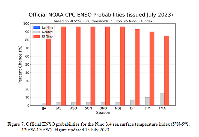
CPC Probability Distribution

Here are the new forecast probabilities. This information in the past has been released twice a month and the first release is based on a survey of Meteorologists, the second is based on model results. The probabilities are for three-month periods e.g. JJA stands for June/July/August. The first forecast forecast is used to develop the Seasonal Outlook which will be issued next Thursday so that is what I am focusing on.

Here is the current release of the probabilities:

You can clearly see The forecast does not extend beyond FMA 2024 but one does see a slight tail-off in the probabilities for El Nino conditions in the Eastern Pacific after the winter season.

NOAA Updates their Seasonal Outlook – June 17, 2023

On the third Thursday of the month right on schedule NOAA issued what I describe as their Four-Season Outlook. The information released also included the Mid-Month Outlook for the single month of July plus the weather and drought outlook for the next three months.  I present the information issued by NOAA and try to add context to it. It is quite a challenge for NOAA to address the subsequent month, the subsequent three-month period as well as successive three-month periods for a year or a bit more. A seasonal drought outlook is also issued.

It is very useful to read the excellent discussion that NOAA issues with this Seasonal Outlook.  The overall level of confidence in the Seasonal Outlook is addressed in the NOAA discussion. It is best to read the full discussion but here are some of the highlights:

Re ENSO:

  • “NOAA’s CPC forecast calls for more than a 90 percent chance of El Niño persisting through JFM 2024 with a 56 percent chance of a strong El Niño (> 1.5 degrees C) during NDJ 2023.”

For July:

  • “Above normal temperatures are favored from the Four Corners region, across the central and southern Great Plains, the Southeast, and the Northeast.”
  • “A weakened monsoon during July across eastern Arizona and New Mexico is predicted”
  • “a strong subtropical ridge, which would favor above-normal precipitation from the southern Great Plains northward and into the Mid-Atlantic”
  • “a storm track across the northern Great Plains and into the Ohio River valley”

For JAS 2023:

  • “The highest probabilities (more than 50 percent) of above-normal temperatures are forecast across parts of California, the Pacific Northwest, Great Basin, Southwest, Gulf Coast, and East.”
  • “elevated probabilities of below-normal precipitation for parts of the Southwest, Pacific Northwest, and Great Lakes, while above-normal precipitation is favored across much of the Great Plains, parts of the Middle to Lower Mississippi Valley, Northern Rockies, and Florida Peninsula.”

Beyond JAS  2023:

  •  “Above-normal temperatures remain the most likely outcome throughout much of the U.S. from ASO to OND 2023.”
  •  “Beginning in NDJ 2023-24 through JFM 2024, predicted El Niño conditions result in enhanced chances for above-normal temperatures across the northern tier of the CONUS”
  •  “During the winter 2023-24, above-normal temperatures are favored across the East”
  •  “Precipitation outlooks during the fall 2023 through the winter 2023-24 relied upon El Niño composites and the consolidation tool with an increased chance of above (below)-normal precipitation across the southern (northern) tier of the CONUS.”
  •  “The largest probabilities (50 percent for above) are forecast across parts of the Southeast from NDJ 2023-24 through JFM 2024 based on a strong, reliable wet signal associated with El Niño.
  •  “During the spring and summer 2023, the precipitation outlooks are based mostly on decadal trends.”

Weekly Crop Report June 15, 2023 – It looks now more like an average crop.

This article is based primarily on the June 13, 2023, USDA Crop Bulletin which covers the June 5 to June 11 period of time. The USDA report usually becomes available on Tuesdays but I am a day late publishing my report.

It now seems more like an average crop.  Soybeans, which are a major crop are doing very well. Corn had a very good start but the quality of the crop has been compromised by drought.

We also include recent reports on the Broiler Hatchery and the Turkey Hatchery.

The article includes a short international review of agricultural conditions.

We also provide a short review of last week’s change in ENSO Status.

Weather: Tonight, Tomorrow, Next Day, Five Days, and Intermediate-Term Outlooks for the U.S. and a Six-Day Forecast for the World: posted June 15, 2023

Here is what we are paying attention to in the next 48 to 72 hours. The article also includes weather maps for longer-term outlooks and a five-day World weather forecast.

We start with the U.S. Information.

Short Range Forecast Discussion
NWS Weather Prediction Center College Park MD
Thu Jun 15 2023

Valid 12Z Thu Jun 15 2023 – 12Z Sat Jun 17 2023

…Numerous severe thunderstorms expected today across parts of the
central and southern Plains…

…Additional chances for flash flooding and severe weather throughout the
central/eastern Gulf Coast and Southeast, as well as into the central High
Plains through Friday…

…Mid-June heat wave underway across much of Texas and the Deep South…

…Poor air quality due to Canadian wildfire smoke forecast over the
northern Plains and Midwest today…

Our Report on the JAMSTEC Three-Season Forecast – May 15, 2023

The Japan Agency for Marine-Earth Science and Technology, or JAMSTEC, is a Japanese national research institute for marine-earth science and technology

From the JAMSTEC Discussion:

“Observation shows that the La Niña Modoki-like state persists. The SINTEX-F ensemble mean predicts that an El Niño will occur in June. However, there is a large uncertainty in the predictions of the amplitude, and the ensemble mean of the SINTEX-F2-3DVAR version predicts a relatively weak El Niño.” [This puts JAMSTEC in disagreement with NOAA and most other Meteorological Agencies]

Although it is a World forecast, it includes a forecast for North America since North America is part of the World.

NOAA Updates its ENSO Alert on May 11, 2023 – El Nino now 90% Likely

Lightly Edited at 9:39 p.m. Saturday, May 12, 2023 to add some details that I was too exhausted to sort out when I published early this morning.

On the second Thursday of every month, NOAA issues its analysis of the status of ENSO. This includes determining the Alert System Status.  NOAA again describes their Report as “ENSO Alert System Status: El Nino Watch”

There is not much doubt that we will have an El Nino.

From the NOAA Analysis:

The combination of a forecasted third westerly wind event in mid-late May, and high levels of above-average oceanic heat content, means that a potentially significant El Niño is on the horizon.  While at least a weak El Niño is likely, the range of possibilities at the end of the year (November-January) include a 80% chance of at least a moderate El Niño (Niño-3.4 greater than or equal to  1.0°C) to a ~55% chance of a strong El Niño (Niño-3.4 greater than or equal to 1.5°C).  It is still possible the tropical atmosphere does not couple with the ocean, and El Niño fails to materialize (5-10% chance).

Two Multi-seasonal Weather Outlooks: NOAA and JAMSTEC April 22, 2023

Some additional light editing at 5:03 p.m  EDT Sunday April 23, 2023 to explain a difference in the way the two agencies present information.

Here we present two multi-season weather outlooks.
NOAA provides such an outlook for the U.S. every month and JAMSTEC does so for the World. Their world outlook of course includes the U.S.  I used to compare the two. The reader can do this themselves.

The JAMSTEC forecast is of interest partly because both Japan and the US.  have weather that is mostly based on the Pacific Ocean.

NOAA Updates it’s Four-Season Outlook on April 20, 2023 – The Southwest Monsoon is expected to be less productive than usual. An El Nino Winter is Expected

On the third Thursday of the month right on schedule NOAA issued what I describe as their Four-Season Outlook. The information released also included the Mid-Month Outlook for the single month of May plus the weather and drought outlook for the next three months.  I present the information issued and try to add context to it. It is quite a challenge for NOAA to address the subsequent month, the subsequent three-month period as well as successive three-month periods for a year or a bit more.

It is very useful to read the excellent discussion that NOAA issues with this Seasonal Outlook. It is best to read the full discussion but here are some of the highlights:

  • ENSO-neutral conditions are expected to continue through the Northern Hemisphere spring, followed by a 62% chance of El Niño developing during May-July 2023. An El Niño Watch has been issued, and the range of possibilities toward the end of the year includes a strong El Niño (4 in 10 chance of Niño-3.4 ≥ 1.5°C) to no El Niño (1 in 10 chance)
  • The combination of elevated snowpack and high soil moisture across much of the West coupled with below normal SSTs currently observed in the Gulf of California and the Pacific off the west Coast of the Baja California Peninsula would favor a slower evolution of monsoonal circulation.
  • El Niño is expected to become more of a factor and the pattern begins to increasingly reflect El Niño conditions during the cold months. As a result, enhanced probabilities of above normal temperatures indicated for the Southern CONUS late summer/early fall are reduced by the winter. Conversely, chances of above normal temperatures increase across the Northern Tier by the winter months.
  • As we enter the fall and winter months, the pattern begins to increasingly reflect an El Niño signature. Increased probabilities for above normal precipitation depicted across the Ohio and Mississippi Valleys during late summer and early fall transitions to the East and Gulf Coasts during the winter months, consistent with El Niño. Conversely, an increasingly dry signal is evident across the northwestern CONUS by the winter with probabilities of below normal precipitation exceeding 40 percent across the Pacific Northwest from November-December-January (NDJ) 2023-24 through JFM 2024. A tilt toward below normal precipitation is also indicated for the Great Lakes Region westward toward the Northern Plains during the cold months, consistent with El Niño.

NOAA Updates its ENSO Alert Status to El Nino Watch on April 13, 2023

Additional editing at 11:01 p.m. EDT April 14, 2023. I noticed that a map had dropped out of the article so I replaced it and I expanded the discussion blocks. I moved some graphics around. It will be easier to read now. While preparing the article I had not realized the extent of the changes. So I have better highlighted those changes now.

On the second Thursday of every month, NOAA issues its analysis of the status of ENSO. This includes determining the Alert System Status.  NOAA describes their Report as “ENSO Alert System Status: El Nino Watch”

If you read the fine print you can see that

“While the lower accuracy of forecasts during the spring can result in surprises, the recent oceanic Kelvin wave plus recurring westerly wind anomalies are anticipated to further warm the tropical Pacific Ocean.  The coastal warming in the eastern Pacific may foreshadow changes across the Pacific basin.  Therefore, an El Niño Watch has been issued, and the range of possibilities toward the end of the year includes a strong El Niño (4 in 10 chance of Niño-3.4 ³ 1.5°C) to no El Niño (1 in 10 chance).  In summary, ENSO-neutral conditions are expected to continue through the Northern Hemisphere spring, followed by a 62% chance of El Niño developing during May-July 2023.”

The article includes two very interesting posts from the ENSO Blog. They are worth reading.