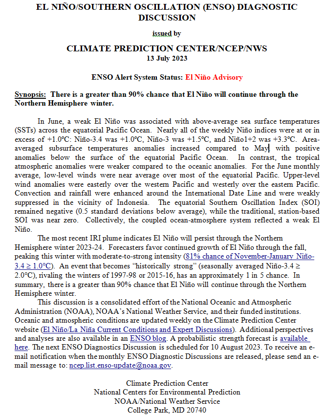
NOAA Updates its ENSO Alert on July 13, 2023 – El Nino is here and 90% Likely to Last through Winter with a 20% Chance of a MegaNino

On the second Thursday of every month, NOAA issues its analysis of the status of ENSO. This includes determining the Alert System Status.  NOAA again describes their Report as “ENSO Alert System Status: El Nino Watch”

There is not much doubt that we have an El Nino. How long it lasts and its strength remains to be seen.

From the NOAA Analysis:

CLIMATE PREDICTION CENTER ENSO DISCUSSION

The second paragraph is what is important:

“The most recent IRI plume indicates El Niño will persist through the Northern Hemisphere winter 2023-24.  Forecasters favor continued growth of El Niño through the fall, peaking this winter with moderate-to-strong intensity (81% chance of November-January Niño-3.4 ≥1.0C).  An event that becomes “historically strong” (seasonally averaged Niño-3.4 ≥ 2.0C), rivaling the winters of 1997-98 or 2015-16, has an approximately 1 in 5 chance.  In summary, there is a greater than 90% chance that El Niño will continue through the Northern Hemisphere winter.

We now provide additional detail.

CPC Probability Distribution

Here are the new forecast probabilities. This information in the past has been released twice a month and the first release is based on a survey of Meteorologists, the second is based on model results. The probabilities are for three-month periods e.g. JJA stands for June/July/August. The first forecast forecast is used to develop the Seasonal Outlook which will be issued next Thursday so that is what I am focusing on.

Here is the current release of the probabilities:
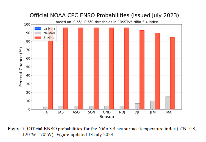
You can clearly see The forecast does not extend beyond FMA 2024 but one does see a slight tail-off in the probabilities for El Nino conditions in the Eastern Pacific after the winter season.

NOAA Updates it’s ENSO Forecast on March 9, 2023 – Leaving La Nina Say Hello to ENSO Neutral – But Maybe Not for Long

On the second Thursday of every month, NOAA issues its analysis of the status of ENSO. This includes determining the Alert System Status.  NOAA describes their Report as “ENSO Alert System Status: Final La Niña Advisory”

If you read the fine print you can see that we are still in the transition. We have left La Niña but are not fully into ENSO Neutral. The rules seem to be that when you no longer meet the criteria for La Nina or El Nino, you are in ENSO Neutral even if the atmosphere has not fully transitioned to ENSO Neutral. This makes a lot of sense since in general, the atmosphere reacts to the ocean conditions rather than the ocean reacting to the atmosphere but it is not as clear cut as what I have just stated. But typically the reaction of the atmosphere lags the change in the ocean condition and the change in the atmosphere confirms that the change in the ocean will impact weather patterns.

Some of the models suggest a rapid change to El Nino during or after the Summer. It seems likely that the ENSO Neutral Phase will at the very least have an El Nino bias.

We have published a shorter version of our usual article since there is little disagreement that we are transitioning away from La Nina. It is also a bit too early to be confident that we will have an El Nino next winter. We need to get past the Spring Prediction Barrier (SPB) to be confident about having an El Nino soon.

The article includes a very interesting post from the ENSO Blog. It is worth reading. Among other things, it discusses the situation off of Peru which might increase the chances for an El Nino but it also is a warning as to some potentially problematic weather conditions for Peru.

NOAA Updates it’s ENSO Outlook on February 9, 2023 – Changes are Coming

Updated at 3:23 p.m. EST Friday, February 10 to include a second interesting ENSO Blog Article. You have to click where shown to read them.

On the second Thursday of every month, NOAA issues its analysis of the status of ENSO. This includes determining the Alert System Status. The best guess remains March.

This may seem like a repeat of our article from last month and in a way it is since the situation has not changed. But no change increases the confidence in the forecast.

And again some of the models suggest a rapid change to El Nino. It seems likely that the ENSO Neutral Phase will at the very least have an El Nino bias.

Because the situation has not changed, we have published a shorter version of our usual article since there is little disagreement that we are transitioning away from La Nina. It is also a bit too early to examine the potential for an El Nino. We need to get past the Spring Prediction Barrier (SPB) to be confident about having an El Nino soon.

The article includes two very interesting posts from the ENSO Blog. They are worth reading.

NOAA Updates it’s November 2022 ENSO Outlook

On the second Thursday of every month, NOAA issues its analysis of the status of ENSO. This includes determining the Alert System Status. Although the current status remains the same i.e.  La Nina Advisory, the forecast has again been adjusted slightly from the prior month. There is some disagreement on when this La Nina will end with the best guess being perhaps March.

But I have actually seen only a few signs of it starting to happen. But all the meteorologists agree that it will.  Could they all be wrong? Probably not.

NOAA Updates it’s October 2022 ENSO Outlook

On the second Thursday of every month, NOAA issues its analysis of the status of ENSO. This includes determining the Alert System Status. Although the current status remains the same i.e.  La Nina Advisory, the forecast has again been adjusted slightly from the prior month. The IRI analysis suggests it could be slightly later than it appeared last month. Also, the probability that it will extend into the winter is much higher. So what I anticipated as being a three-peat now looks to be a certainty. There is some disagreement on when this La Nina will end with the best guess being perhaps February or March.

But I actually see no sign of it starting to happen. But all the meteorologists agree that it will.  Could they all be wrong?

I also include some interesting graphics that show the impact of the combination of La Nina and what NOAA calls “trend” which is a combination of Global Warming and long cycles.  I find them interesting. The IOD is about over so the weather in the  Indian Ocean should return to something more like normal. The three phases of ENSO basically impact the entire world. It does appear that this third La Nina winter may be quite different from last year. But I will address that when NOAA issues their Seasonal Outlook for the U.S. and when I publish the JAMSTEC world outlook which I already have and I will probably publish it very soon.