NOAA Updates its Seasonal Outlook on July 18, 2024 – Substantially Different from the Outlook Issued last Month – Posted on July 19, 2024

On the third Thursday of the month right on schedule NOAA issued their updated Seasonal Outlook which I describe as their Four-Season Outlook because it extends a bit more than one year into the future. The information released also included the Mid-Month Outlook for the following month plus the weather and drought outlook for the next three months.  I present the information issued by NOAA and try to add context to it. It is quite a challenge for NOAA to address the subsequent month, the subsequent three-month period as well as the twelve successive three-month periods for a year or a bit more.

With respect to the long-term part of the Outlook which I call the Four-Season Outlook, the timing of the transition from Neutral to LaNina is challenging to predict.  We are now in ENSO Neutral. La Nina is the likely scenario for this summer almost to the end of the forecast period.

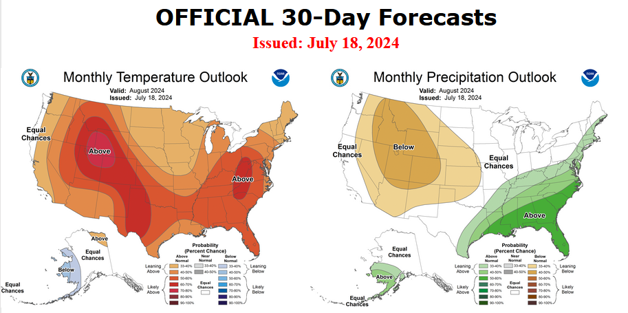
First, Let’s Take a Look at the (mid-month) Outlook for August

It will be updated on the last day of July.

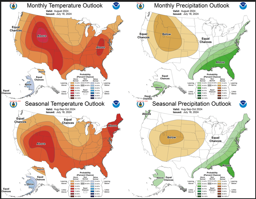
The top row is what is now called the Mid-Month Outlook for next month which will be updated at the end of this month. There is a temperature map and a precipitation map. The second row is a three-month outlook that includes next month.  I think the outlook maps are self-explanatory. What is important to remember is that they show deviations from the current definition of normal which is the period 1991 through 2020.  So this is not a forecast of the absolute value of temperature or precipitation but the change from what is defined as normal or to use the technical term “climatology”.

Notice that the Outlook for next month and the three-month Outlook are fairly similar. This tells us that September and October will be fairly similar to August.

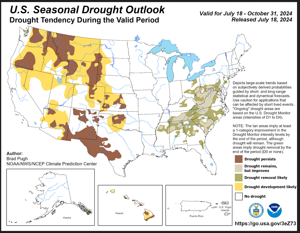
The expansion of the area impacted by drought development is extensive but different than what was predicted last month.  There is also a large area of drought improvement.

The full NOAA Seasonal Outlook extends through August/September/October of 2025 (yes that is more than a year out). All of these maps are in the body of the article. Large maps are provided for August and the three-month period August/September/October.  Small maps are provided beyond that through August/September/October of 2025 with a link to get larger versions of these maps.

NOAA provides a discussion to support the maps. It is included in the body of this article. In some cases, one will need to click on “read more” to read the full article. For those on my email list where I have sent the url of the article, that will not be necessary.

NOAA Updates it’s Four-Season Outlook on April 20, 2023 – The Southwest Monsoon is expected to be less productive than usual. An El Nino Winter is Expected

On the third Thursday of the month right on schedule NOAA issued what I describe as their Four-Season Outlook. The information released also included the Mid-Month Outlook for the single month of May plus the weather and drought outlook for the next three months.  I present the information issued and try to add context to it. It is quite a challenge for NOAA to address the subsequent month, the subsequent three-month period as well as successive three-month periods for a year or a bit more.

It is very useful to read the excellent discussion that NOAA issues with this Seasonal Outlook. It is best to read the full discussion but here are some of the highlights:

  • ENSO-neutral conditions are expected to continue through the Northern Hemisphere spring, followed by a 62% chance of El Niño developing during May-July 2023. An El Niño Watch has been issued, and the range of possibilities toward the end of the year includes a strong El Niño (4 in 10 chance of Niño-3.4 ≥ 1.5°C) to no El Niño (1 in 10 chance)
  • The combination of elevated snowpack and high soil moisture across much of the West coupled with below normal SSTs currently observed in the Gulf of California and the Pacific off the west Coast of the Baja California Peninsula would favor a slower evolution of monsoonal circulation.
  • El Niño is expected to become more of a factor and the pattern begins to increasingly reflect El Niño conditions during the cold months. As a result, enhanced probabilities of above normal temperatures indicated for the Southern CONUS late summer/early fall are reduced by the winter. Conversely, chances of above normal temperatures increase across the Northern Tier by the winter months.
  • As we enter the fall and winter months, the pattern begins to increasingly reflect an El Niño signature. Increased probabilities for above normal precipitation depicted across the Ohio and Mississippi Valleys during late summer and early fall transitions to the East and Gulf Coasts during the winter months, consistent with El Niño. Conversely, an increasingly dry signal is evident across the northwestern CONUS by the winter with probabilities of below normal precipitation exceeding 40 percent across the Pacific Northwest from November-December-January (NDJ) 2023-24 through JFM 2024. A tilt toward below normal precipitation is also indicated for the Great Lakes Region westward toward the Northern Plains during the cold months, consistent with El Niño.

NOAA Updates its Four Season Outlook on December 15, 2022 – La Nina Winter then Big Changes

La Nina Winter, then ENSO Neutral and then maybe something else (this is very little change from last month’s assessment)

Today is the third Thursday of the month so right on schedule NOAA has issued what I describe as their Four-Season Outlook. The information released also includes the MId-Month Outlook for the single month of January plus the weather and drought outlook for the next three months.  I present the information issued and try to add context to it. It is quite a challenge for NOAA to address the subsequent month, the subsequent three-month period as well as successive three-month periods for a year or a bit more.

We will begin to see the impacts of the end of La Nina for precipitation in March/April/May of 2023 and for temperature in May/June/July of 2023.

The maps show a series of changes which I have highlighted in my comments. Next winter will be very different than this winter.

It is very useful to read the excellent discussion that NOAA issues with this Seasonal Outlook. NOAA seems to be more confident about making predictions beyond six months. They even predict a good Southwest Monsoon next summer which they never used to do this far in advance.