Updating the U.S. Summer Monsoon – Posted on August 3, 2024

It was forecast to be a subpar monsoon,  but it is not turning out that way.

But first a digression.

American Monsoons

NOAA/ National Weather Service
NOAA Center for Weather and Climate Prediction
Climate Prediction Center
5830 University Research Court
College Park, Maryland 20740
Page Author: Climate Prediction Center Internet Team

HERE is a link for more information on Monsoons.

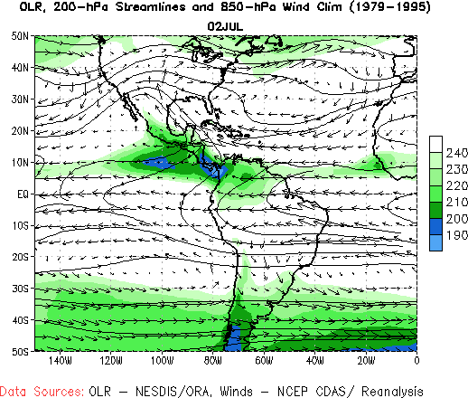
 The above is pretty interesting because it shows that what we call The Monsoon (with the use of different names) is a process that impacts the Northern Hemisphere in the summer and South America in their summer. Very few people are aware of this. The above shows this. For South America, their Monsoon occurs over a period of time first impacting the Amazon Basin and then the La Plata Basin.
I only mention this because the Monsoon is a more significant weather pattern than most realize. I found this graphic to be hard to decipher but did not have time to find a better one. But you can see the change in direction of the wind which is the definition of a monsoon namely a seasonal change in the direction of the prevailing wind.

Now we will focus on the North American Monsoon (NAM)

The organization CLIMAS is an expert in this area and they recently issued an update report.  Most of the rest of this article is taken from their report but they had a couple of three-month forecast slides which I have replaced with what NOAA issued on July 31, 2024, so they are a bit more current.

Where I have comments on their slides my comments are in boxes.

Some will need to click on “Read More” to access the full article.

NOAA Updates its April 2023 Weather Outlook – There are Significant Changes which are mostly Wetter – Posted on April 1, 2024

At the end of every month, NOAA updates its Outlook for the following month which in this case is April of 2024. We are reporting on that tonight.

There have been some significant changes in the Outlook for April and these are addressed in the NOAA Discussion so it is well worth reading.  We provided the prior Mid-Month Outlook for April for comparison. It is easy to see the changes by comparing the Mid-Month and Updated Maps.

The article includes the Drought Outlook for April. NOAA also adjusted the previously issued Seasonal (AMJ) Drought Outlook to reflect the changes in the April Drought Outlook. We have included a map showing the amount of water in the snowpack waiting to be released in the Spring. We also provide the Week 2/3 Tropical Outlook for the World.  We also include a very interesting CLIMAS Discussion.

The best way to understand the updated outlook for April is to view the maps and read the NOAA discussion. I have highlighted the key statements in the NOAA Discussion.

I am going to start with graphics that show the updated Outlook for April and the Mid-Month Outlook for April. This is followed by a graphic that shows both the Updated Outlook for April and the previously issued three-month outlook for AMJ 2024. So you get the full picture in three graphics.

Here is the updated Outlook for April 2024.

For Comparison Purposes, Here is the earlier Mid-Month Outlook for April

There have been some significant changes. Remember, it is the top set of maps that are the current outlook for April.

Combination of the Updated Outlook for April and the Three-Month Outlook

The top row is the Updated Outlook for the new month. There is a temperature map and a precipitation map. The second row is a three-month outlook that includes the new month. I think the outlook maps are self-explanatory. What is important to remember is that they show deviations from the current definition of normal which is the period 1991 through 2020.  So this is not a forecast of the absolute value of temperature or precipitation but the change from what is defined as normal or to use the technical term climatology.
The three-month map was issued on March 21, 2024.  One expects some changes  10 days later. But the changes to both maps are fairly dramatic.  This then gives us some reason to question the three-month AMJ temperature and  precipitation Outlooks.

Some readers may need to click “Read More” to read the rest of the article.  Some will feel that they have enough information. But there is a lot more information in the rest of this article.

Mar 2022 Southwest Climate Podcast – Cold(ish), Windy, and Dry – Winter Recap & Looking Ahead

In the March 2022 edition of the CLIMAS Southwest Climate Podcast, Mike Crimmins and Zack Guido “dive into a recap of winter (so far) in the Southwest. First, recap winter to date, and put it in the context of a double-dip La Niña, including precipitation totals, temperature, and snowpack. Then they take a closer look at the phases of the PNA (Pacific/North American pattern) and how this links to ENSO/La Niña and the weather conditions this winter. Finally, they revisit temperature to consider just how “cold” it has actually been, and preview a closer look at fire outlooks, snowpack, and water supply in upcoming podcasts”.