Weather Outlook for the U.S. for Today Through at Least 22 Days and a Six-Day Forecast for the World: posted September 26, 2024

This article focuses on what we are paying attention to in the next 48 to 72 hours. The article also includes weather maps for longer-term U.S. outlooks (up to four weeks) and a six-day World weather outlook which can be very useful for travelers.

First the NWS Short Range Forecast. The afternoon NWS text update can be found here after about 4 p.m. New York time but it is unlikely to have changed very much from the morning update. The images in this article automatically update.

Short Range Forecast Discussion
NWS Weather Prediction Center College Park MD
Thu Sep 26 2024
Valid 12Z Thu Sep 26 2024 – 12Z Sat Sep 28 2024

…Helene is forecast to rapidly intensify to a major hurricane in the
Gulf today and bring life-threatening impacts to Florida and the Southeast
through Friday…

…Rare High Risks of excessive rainfall are in place for parts of the
Florida Panhandle where Helene will make landfall, and for the southern
Appalachians where catastrophic flash flooding and landslides are
expected...

…Above average temperatures and summer-like warmth forecast to stretch
from the Southwest to northern Plains…

Hurricane Helene is moving northward through the Gulf of Mexico this
morning and is forecast to become a major hurricane before making
landfall. Potentially catastrophic hurricane-force winds are expected
within the eyewall of Helene when it makes landfall in the Florida Big
Bend region this evening. Because Helene is becoming a large system and
will initially move inland quickly, damaging and life-threatening
hurricane-force winds, especially in gusts, will penetrate well inland
over portions of northern Florida and southern Georgia late Thursday and
Thursday night where Hurricane Warnings are in effect. Strong wind gusts
are also likely farther north across portions of northern Georgia and the
Carolinas, particularly over the higher terrain of the southern
Appalachians. Additionally, catastrophic and deadly storm surge is likely
along portions of the Florida Big Bend coast, where inundation could reach
as high as 20 feet above ground level, along with destructive waves. There
is also a danger of life-threatening storm surge along the remainder of
the west coast of the Florida Peninsula. Prepare now and heed instructions
from local officials about evacuations in these areas. Please refer to the
National Hurricane Center for the latest updates on the track and timing
of Helene.

Helene will also cause significant rainfall and flooding threats. Even
ahead of Helene itself, tropical moisture continues to be pulled north
into the Southeast to southern Appalachians ahead of a slow-moving upper
trough/low and surface front, currently causing rainfall and flooding that
will last through the day. Heavy to extreme rainfall from yesterday has
also led to wet antecedent conditions in places where Helene will track. A
rare High Risk (level 4/4) remains in place in WPC’s Excessive Rainfall
Outlook (ERO) across portions of Georgia into the southern Appalachians
where upslope flow should increase rain totals and varying terrain is
likely to lead to landslides. Additionally, a separate area of extreme
rainfall is also likely near the core of the storm as it passes over the
Florida Panhandle, where a separate High Risk is in effect in the Day 1
ERO. A broad Slight Risk (level 2/4) with an embedded Moderate Risk (level
3/4) over the Appalachians is in place for Friday for continued rainfall.
Overall, Helene is forecast to produce total rain accumulations of 6 to 12
inches, with isolated totals around 20 inches, over portions of the
Southeast into southern Appalachians. Catastrophic and life-threatening
flash and urban flooding, including numerous significant landslides, is
expected across portions of the southern Appalachians through Friday.
Considerable to locally catastrophic flash and urban flooding is likely
for northwestern and northern Florida and the Southeast through Friday.
Widespread significant river flooding and isolated major river flooding
are likely. Another weather hazard associated with Helene to monitor is
the tornado threat, especially on the eastern side of the track. The Storm
Prediction Center is indicating a Slight to Enhanced Risk of severe
weather, primarily for tornadoes, today into tonight for parts of Florida
into Georgia and South Carolina/southeastern North Carolina.

Elsewhere, showers and storms are also possible farther north in the
eastern U.S. along the northern part of the frontal system over the next
couple of days. A couple of fronts passing through the Northwest should
lead to some precipitation there and gusty winds. Meanwhile the rest of
the western U.S. stretching into the north-central U.S. can expect dry
conditions with warmer than average temperatures. The Desert Southwest
will see highs well into the 100s and low 110s, which has prompted
Excessive Heat Warnings from south-central Arizona into the high deserts
of southern California. High into the 90s are likely in the northern High
Plains today, with 80s stretching into the Upper Midwest through the end
of the week. Record warm temperatures are possible for both morning lows
and afternoon highs.

cone graphic

https://www.nhc.noaa.gov/storm_graphics/AT09/refresh/AL0924WPCERO+gif/032536WPCERO_sm.gif

To get your local forecast plus active alerts and warnings click HERE and enter your city, state or zip code.


Learn about wave patterns HERE.

Then, looking at the world and of course, the U.S. shows here also. Today we are looking at precipitation.

Please click on “Read More” below to access the full Daily Report issued today.

Weather Outlook for the U.S. for Today Through at Least 22 Days and a Six-Day Forecast for the World: posted September 25, 2024

This article focuses on what we are paying attention to in the next 48 to 72 hours. The article also includes weather maps for longer-term U.S. outlooks (up to four weeks) and a six-day World weather outlook which can be very useful for travelers.

First the NWS Short Range Forecast. The afternoon NWS text update can be found here after about 4 p.m. New York time but it is unlikely to have changed very much from the morning update. The images in this article automatically update.

Short Range Forecast Discussion
NWS Weather Prediction Center College Park MD
Wed Sep 25 2024
Valid 12Z Wed Sep 25 2024 – 12Z Fri Sep 27 2024

…Helene is forecast to rapidly intensify to a major hurricane in the
Gulf and bring life-threatening impacts to Florida and the Southeast late
today through Friday…

…A rare High Risk of excessive rainfall is in place for the southern
Appalachians Thursday-Thursday night where considerable flash/urban/river
flooding and landslides are possible…

Current Tropical Storm Helene is forecast to quickly become a hurricane
today and become a major hurricane before making landfall on Thursday. A
Hurricane Warning is in effect over the Florida Big Bend for damaging
hurricane-force winds. Helene will grow in size as it strengthens,
spreading its impacts to much of Florida and the Southeast. There is a
danger of life-threatening storm surge along the entire west coast of the
Florida Peninsula and Florida Big Bend. The highest inundation levels are
expected along the coast of the Florida Big Bend. Prepare now and heed
instructions from local officials about evacuations in these areas. Please
refer to the National Hurricane Center for the latest updates on the track
and timing of Helene.

Helene will also cause significant rainfall and flooding threats. Even
ahead of Helene itself, tropical moisture will be pulled north into the
Southeast to southern Appalachians today and tonight ahead of a
slow-moving upper trough/low. This moisture will pool along and ahead of a
stalling front at the surface and lead to excessive rainfall. A Moderate
Risk is in place in WPC’s Excessive Rainfall Outlook (ERO) across portions
of Georgia into the southern Appalachians today into tonight within a
broader Slight Risk, in addition to Slight Risks of flash flooding in
parts of the Florida Peninsula and West Coast as Helene approaches.
Today’s rainfall is forecast to create wet antecedent conditions that
should likely overlap heavy rain along Helene’s track Thursday-Friday.
Thus a High Risk of excessive rainfall is delineated across the southern
Appalachians where upslope flow should increase rain totals and varying
terrain could lead to landslides. Overall, 5 to 10 inches of rain with
isolated totals around 15 inches is forecast over the Southeast.
Considerable flash and urban flooding is expected across portions of
Florida, the Southeast, southern Appalachians, and the Tennessee Valley
Wednesday through Friday. This includes the risk of landslides across the
southern Appalachians. Widespread minor to moderate river flooding is
likely, and isolated major river flooding is possible. Additionally, there
is a tornado threat with Helene, especially on the eastern side of the
track. The Storm Prediction center is indicating a Slight to Enhanced Risk
of severe weather, primarily for tornadoes, on Thursday into Thursday
night for parts of Florida into Georgia and South Carolina.

Elsewhere, showers and storms are also possible farther north in the
eastern U.S. along the northern part of the frontal system over the next
couple of days. A couple of fronts passing through the Northwest should
lead to some precipitation there. Meanwhile the rest of the western U.S.
stretching into the north-central U.S. can expect dry conditions with
warmer than average temperatures. The Desert Southwest will see highs well
into the 100s, and 90s are possible in the northern High Plains. Some
record temperatures are possible for lows and highs.

cone graphic

To get your local forecast plus active alerts and warnings click HERE and enter your city, state or zip code.


Learn about wave patterns HERE.

Then, looking at the world and of course, the U.S. shows here also. Today we are looking at precipitation.

Please click on “Read More” below to access the full Daily Report issued today.

Weather Outlook for the U.S. for Today Through at Least 22 Days and a Six-Day Forecast for the World: posted September 24, 2024

This article focuses on what we are paying attention to in the next 48 to 72 hours. The article also includes weather maps for longer-term U.S. outlooks (up to four weeks) and a six-day World weather outlook which can be very useful for travelers.

First the NWS Short Range Forecast. The afternoon NWS text update can be found here after about 4 p.m. New York time but it is unlikely to have changed very much from the morning update. The images in this article automatically update.

Short Range Forecast Discussion
NWS Weather Prediction Center College Park MD
Tue Sep 24 2024
Valid 12Z Tue Sep 24 2024 – 12Z Thu Sep 26 2024

…Potential Tropical Cyclone Nine is forecast to pass not too far from
the Florida Keys Wednesday night as a hurricane before skirting up the
West Coast of Florida by Thursday morning…

…Much needed rainfall from the Ohio Valley into the central to southern
Appalachians, Upper Tennessee Valley and Mid-Atlantic…

…Much above average temperatures continue across the West into the
Northern Plains and across the Gulf Coast into the Southeast…

A relatively benign mid- to upper-level trough that will likely bring
beneficial rainfall for the eastern U.S. is forecast to deepen when
another upper-level trough over the northern Plains drops southeast and
merges with the lead trough. The resulting trough amplification will be
instrumental in pulling the tropical moisture as well as Potential Cyclone
Nine (PTC9) northward into the eastern portion of the Gulf of Mexico by
the end of the short-range forecast period on Thursday morning.

The initial impacts from the lead trough will be in the form of an
expanding area of moderate to heavy rainfall potential from the Midwest
into the lower Great Lakes, Ohio Valley, upper Tennessee Valley, central
to southern Appalachians into the Mid-Atlantic near and ahead of a low
pressure wave. Much of these areas are currently experiencing severe to
exceptional drought conditions, with the expected 1 to 1.5 inch plus
rainfall amount over the next two days bringing some relief to these
drought conditions. With the dry conditions across these areas, river
flooding will be unlikely. However, there is still at least a marginal
risk of isolated flash flooding with the expected heavy rainfall amounts,
especially if they occur over urbanized regions.

As the above-mentioned amplifying pattern develops over the northern
Plains and dips toward the Deep South, PTC9 is forecast to track more
toward the north and intensify rapidly as it moves across the Yucatan
Channel on Wednesday and then pass not too far from the Florida Keys
Wednesday night. The Florida Keys can expect strengthening winds with
more frequent passages of squally downpours Wednesday night as PTC9 is
forecast to pass to the west as a hurricane. Computer models indicate
that the circulation of PTC9 will expand as it interacts with the
deepening upper trough in the Deep South. Given a more robust convective
structure concentrated more on the east side of the storm, the West Coast
of Florida could begin to see more frequent and intense squalls with winds
further strengthening by Thursday morning. Please refer to the National
Hurricane Center for the latest updates on this system.

The amplifying upper ridge across the interior West will be supporting
widespread much above average temperatures over the next few days across
nearly all of the West and into the Northern Plains. High temperatures
across these regions are forecast to be as much as 10 to 20 degrees above
average. Above average temperatures also likely across the Gulf Coast and
into the Southeast. While temperatures are forecast to be much above
across these areas over the next few days, there are not expected to be
many record highs. However, more numerous record high morning
temperatures are possible both today and Wednesday morning along the West
coast and from portions of the southern Mid-Atlantic into the Southeast
and Florida. Across the Pacific Northwest, the cold front associated
with a Pacific cyclone centered over the Gulf of Alaska will only bring
some rainfall into the region by Wednesday.

cone graphic

To get your local forecast plus active alerts and warnings click HERE and enter your city, state or zip code.


Learn about wave patterns HERE.

Then, looking at the world and of course, the U.S. shows here also. Today we are looking at precipitation.

Please click on “Read More” below to access the full Daily Report issued today.

Weather Outlook for the U.S. for Today Through at Least 22 Days and a Six-Day Forecast for the World: posted September 23, 2024

This article focuses on what we are paying attention to in the next 48 to 72 hours. The article also includes weather maps for longer-term U.S. outlooks (up to four weeks) and a six-day World weather outlook which can be very useful for travelers.

First the NWS Short Range Forecast. The afternoon NWS text update can be found here after about 4 p.m. New York time but it is unlikely to have changed very much from the morning update. The images in this article automatically update.

Short Range Forecast Discussion
NWS Weather Prediction Center College Park MD
Mon Sep 23 2024
Valid 12Z Mon Sep 23 2024 – 12Z Wed Sep 25 2024

…Threat of heavy rain and locally strong to severe thunderstorms will
slowly shift from the southern Plains this morning to the Ohio Valley,
central Appalachians and lower Great Lakes on Tuesday into early
Wednesday…

…Watching the western Caribbean Sea for tropical cyclone formation that
could bring strengthening winds and passing squally downpours into the
Florida Keys Tuesday night into Wednesday morning…

A low pressure consolidating over the southern Plains along a slow-moving
front is forecast to move northeastward through the Mid-Mississippi Valley
by tonight, then across the Midwest and Ohio Valley on Tuesday. Heavy
showers and some severe thunderstorms this morning across the southern
Plains are expected to taper off as today progresses but the threat of
heavy rain and locally strong to severe thunderstorms will increase from
the Mid-Mississippi Valley into the Midwest in the mean time. By Tuesday,
the center of the low will pass through the Midwest toward the lower Great
Lakes, the threat of heavy rain and embedded strong thunderstorms will
then develop well ahead of the low across the Ohio Valley, mainly from
Tuesday afternoon into Tuesday night. By early Wednesday, many areas
across the lower Great Lakes and the interior East Coast will be
enshrouded by showers and embedded thunderstorms. These showers and
storms will extend farther southwest near/along the trailing front across
the interior Gulf Coast states. Showers and periods of rain will also
move across the lower Great Lakes into the central Appalachians and
upstate New York in association with another wave of low pressure near the
front.

The upper-level low behind the slow-moving front will slide across the
central Plains, allowing much of the western U.S. to remain dry along with
a warming trend for the next couple of days. Meanwhile, colder air will
remain entrenched across the Plains behind the front but 90s will be
common in the afternoon across the South and into the interior Southeast
today and Tuesday ahead of the front. The outer edge of a Pacific cyclone
centered over the Gulf of Alaska will only bring some light rain into
northwestern Washington State this morning.

Farther south into the tropics, the National Hurricane Center continues to
watch the western Caribbean Sea for potential tropical cyclone formation.
Computer models now appear to be in good agreement for the system to move
northwestward and reach the Yucatan Channel by the time the short-range
forecast period ends Wednesday morning. This means that the Florida Keys
could experience strengthening winds along with passing squally downpours
from Tuesday night into Wednesday morning. Please refer to the National
Hurricane Center for the latest updates on this system.

To get your local forecast plus active alerts and warnings click HERE and enter your city, state or zip code.


Learn about wave patterns HERE.

Then, looking at the world and of course, the U.S. shows here also. Today we are looking at precipitation.

Please click on “Read More” below to access the full Daily Report issued today.

Weather Outlook for the U.S. for Today Through at Least 22 Days and a Six-Day Forecast for the World: posted September 22, 2024

This article focuses on what we are paying attention to in the next 48 to 72 hours. The article also includes weather maps for longer-term U.S. outlooks (up to four weeks) and a six-day World weather outlook which can be very useful for travelers.

First the NWS Short Range Forecast. The afternoon NWS text update can be found here after about 4 p.m. New York time but it is unlikely to have changed very much from the morning update. The images in this article automatically update.

Short Range Forecast Discussion
NWS Weather Prediction Center College Park MD
Sun Sep 22 2024
Valid 12Z Sun Sep 22 2024 – 12Z Tue Sep 24 2024

…A low pressure wave will bring showers and possible severe weather
across the central High Plains this morning…

…Rounds of heavy rain and embedded thunderstorms are expected to stretch
from the south-central Plains through the mid-Mississippi Valley, Midwest,
and into the Ohio Valley for the next couple of days…

…Locally heavy rain and strong thunderstorms moving across the interior
Mid-Atlantic this morning…

Much of the active weather for the next couple of days will continue to be
focused in the vicinity of a slow-moving frontal boundary stretching from
the south-central Plains through the mid-Mississippi Valley, Midwest, and
into the Ohio Valley. The strongest thunderstorms are expected to
traverse the Texas and Oklahoma Panhandles early this morning, and then
weaken during the day as they move farther east. Rounds of heavy rain and
embedded thunderstorms can also be found this morning across the central
Plains into the Midwest, followed by addition showers and thunderstorms
forming and moving across Lower Michigan during the day today.

By Monday, a low pressure wave is forecast to organize along the front and
move northeast across the south-central Plains. Showers and embedded
thunderstorms can be expected to accompany the low as well as the frontal
boundary. By Tuesday morning, showers and embedded strong thunderstorms
are expected to move across the Midwest toward the Ohio Valley as the low
pressure center tracks across the region.

Across the interior Mid-Atlantic, a subtle upper-level disturbance is
delivering a round of heavy rain with strong to locally severe
thunderstorms moving from north to south this morning. Meanwhile, recent
wet weather in the vicinity of Cape Cod is lingering into this morning.
As the slow-moving coastal cyclone begins to slide further out into the
Atlantic, the rain is forecast to end during the day today.

The high-elevation of central Colorado is waking up to some wet snow due
to an influx of colder air associated with the upper low. The upper low
will lift into the southern Plains, allowing much of the western U.S. to
remain dry for the next couple of days with near normal temperatures.
Colder air will surge down the Plains behind the front but 90s will be
common in the afternoon across the South into the interior eastern U.S.
ahead of the front.

To get your local forecast plus active alerts and warnings click HERE and enter your city, state or zip code.


Learn about wave patterns HERE.

Then, looking at the world and of course, the U.S. shows here also. Today we are looking at precipitation.

Please click on “Read More” below to access the full Daily Report issued today.

Midwest Drought Update – Published on September 21, 2024

Before we get started on this,  I want to include the key graphic from the Updated Four Season  Outlook that we discussed  HERE  yesterday.

The top row is what is now called the Mid-Month Outlook for next month which will be updated at the end of this month. There is a temperature map and a precipitation map. The second row is a three-month outlook that includes next month.

Some will need to click on “Read More” to read the full article.

Weather Outlook for the U.S. for Today Through at Least 22 Days and a Six-Day Forecast for the World: posted September 21, 2024

This article focuses on what we are paying attention to in the next 48 to 72 hours. The article also includes weather maps for longer-term U.S. outlooks (up to four weeks) and a six-day World weather outlook which can be very useful for travelers.

First the NWS Short Range Forecast. The afternoon NWS text update can be found here after about 4 p.m. New York time but it is unlikely to have changed very much from the morning update. The images in this article automatically update.

Short Range Forecast Discussion
NWS Weather Prediction Center College Park MD
Sat Sep 21 2024
Valid 12Z Sat Sep 21 2024 – 12Z Mon Sep 23 2024

…Threat of heavy rainfall and severe weather will be focused across the
central U.S. and into Midwest for the next couple of days…

…A slow-moving coastal storm will bring another rainy day today across
southeastern New England and coastal flooding during high tides for the
northern Mid-Atlantic coast…

…Much below normal temperatures surge into the central High Plains on
Sunday as above average temperatures shift east from the Plains into the
Ohio and Mississippi Valley…

Most of the active weather for the next couple of days will be focused
across the central U.S. and will slowly shift east into the Midwest by
Monday morning. This is in response to a vigorous upper-level low
pressure system that will swing across the Southwest today and then
interact with a surge of cool air down from western Canada. Thunderstorms
are expected to develop quickly later today across the southern High
Plains where severe weather will be possible as a cold front surges south
and clashes with warm and moist air lifted northward by the upper low. By
Saturday night into Sunday, the main activities will then gradually shift
east across the central Plains toward the mid-Mississippi Valley as low
pressure waves form along the front. Sunday into Monday morning will see
the potential of heavy rain shifting farther east into the Midwest and
toward the Ohio Valley. Meanwhile, colder air behind the system will
change the rain into wet snow across the higher elevations of Colorado
Rockies Saturday night into Sunday morning. Showers and embedded
thunderstorms can also be expected farther north near/behind the cold
front across the northern Plains today, into the upper Midwest tonight,
followed by the upper Midwest and the Great Lakes Sunday into Monday
morning.

Temperatures will fall precipitously on the backside of the cold front
over portions of the southern High Plains and central Plains beginning
Saturday. High temperatures in the 50s will represent 15 to 30 degree
departures from average for the aforementioned areas. Above average
temperatures will be in place across the Midwest and Southeast this
weekend as upper-level ridging extending from Mexico into Texas remains in
place. Elsewhere, a slow-moving coastal storm will bring another rainy
day across southeastern New England with coastal flooding during high
tides for the northern Mid-Atlantic coast for today before the storm
slowly moves out into the Atlantic on Sunday.

To get your local forecast plus active alerts and warnings click HERE and enter your city, state or zip code.


Learn about wave patterns HERE.

Then, looking at the world and of course, the U.S. shows here also. Today we are looking at precipitation.

Please click on “Read More” below to access the full Daily Report issued today.

NOAA Updates its Seasonal Outlook on September 19, 2024 – Similar to the Outlook Issued last Month but the potential La Nina is Downgraded – Posted on September 20, 2024

On the third Thursday of the month right on schedule NOAA issued their updated Seasonal Outlook which I describe as their Four-Season Outlook because it extends a bit more than one year into the future. The information released also included the Mid-Month Outlook for the following month plus the weather and drought outlook for the next three months.  I present the information issued by NOAA and try to add context to it. It is quite a challenge for NOAA to address the subsequent month, the subsequent three-month period as well as the twelve successive three-month periods for a year or a bit more.

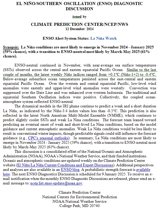
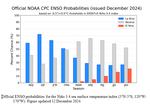
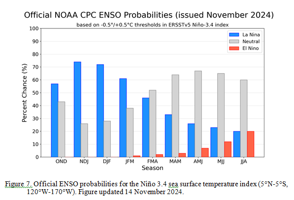
With respect to the long-term part of the Outlook which I call the Four-Season Outlook, the timing of the transition from Neutral to LaNina is challenging to predict.  We are now in ENSO Neutral. La Nina is the likely scenario soon, but the strength of the La Nina may be fairly  weak..

From the NOAA discussion:

“The most recent International Research Institute (IRI) for Climate and Society plume forecast of the Niño-3.4 SST index predicts a weak and a short duration La Niña, as indicated by the Niño-3.4 index values less than -0.5°C. This month, the latest North American Multi-Model Ensemble (NMME) guidance was relied upon, which predicts La Niña to emerge in the next couple of months and continue through the Northern Hemisphere winter. The continuation of negative subsurface temperatures and enhanced low-level easterly wind anomalies supports the formation of a weak La Nina. In summary, La Niña is favored to emerge in SON (71% chance) and is expected to persist through JFM 2025.”

“However, chances of a moderate to strong La Niña are currently less than 50% through the Fall and Winter. ENSO-neutral conditions are favored to re-emerge by the February-April (FMA) 2025 season.”

I personally would not have total confidence in this outlook given the uncertainty about there actually being a La Nina and its strength if it does happen.  I  do not have the JAMSTEC outlook yet but for sure they will lean towards a weak La Nina with Modoki characteristics. I do not have a lot of confidence that NOAA knows how to deal with a La Nina Modoki. But they may have it exactly correct.

Let’s Take a Look at the (mid-month) Outlook for October

It will be updated on the last day of August.

Then we look at a graphic that shows both the next month and the next three months.

The top row is what is now called the Mid-Month Outlook for next month which will be updated at the end of this month. There is a temperature map and a precipitation map. The second row is a three-month outlook that includes next month.  I think the outlook maps are self-explanatory. What is important to remember is that they show deviations from the current definition of normal which is the period 1991 through 2020.  So this is not a forecast of the absolute value of temperature or precipitation but the change from what is defined as normal or to use the technical term “climatology”.

Notice that the Outlook for next month and the three-month Outlook are dissimilar. This tells us that November and December will be substantially different than October.

The full NOAA Seasonal Outlook extends through October/November/December of 2025 (yes that is more than a year out). All of these maps are in the body of the article. Large maps are provided for October and the three-month period October/November/December  Small maps are provided beyond that through October/November/December of 2025 with a link to get larger versions of these maps.

NOAA provides a discussion to support the maps. It is included in the body of this article. In some cases, one will need to click on “read more” to read the full article. For those on my email list where I have sent the url of the article, that will not be necessary.

Weather Outlook for the U.S. for Today Through at Least 22 Days and a Six-Day Forecast for the World: posted September 20, 2024

This article focuses on what we are paying attention to in the next 48 to 72 hours. The article also includes weather maps for longer-term U.S. outlooks (up to four weeks) and a six-day World weather outlook which can be very useful for travelers.

First the NWS Short Range Forecast. The afternoon NWS text update can be found here after about 4 p.m. New York time but it is unlikely to have changed very much from the morning update. The images in this article automatically update.

Short Range Forecast Discussion
NWS Weather Prediction Center College Park MD
Fri Sep 20 2024
Valid 12Z Fri Sep 20 2024 – 12Z Sun Sep 22 2024

…Severe thunderstorm threat will shift from the upper Midwest this
morning to the southern High Plains by Saturday night/early Sunday…

…Rainy weather lingers over southeastern New England…

…A moderate to heavy rain event developing this weekend from the central
High Plains eastward toward the Mid-Mississippi Valley…

…Much above average temperatures through the mid-section of the country
and into Ohio Valley and Great Lakes…

A cold/occluded frontal system clashing with a weak warm front will
continue to support formation of strong to severe thunderstorms across the
upper Midwest early this morning. These thunderstorms will generally lose
intensity as they move into the Great Lakes through the rest of today.
The relatively fast motion of the front will limit rainfall amounts.
However, there is still the potential for isolated heavy totals, that
could result in localized flooding, especially over urbanized regions.

The deep low pressure system associated with the fronts are moving farther
away into central Canada. There will not be much temperature relief in
the wake of the fronts from the much above average temperatures currently
stretching across the Plains into the mid- to upper Mississippi Valley and
Great Lakes. These regions will continue to see some late summer heat
over the next two days. An Alberta clipper will take shape and will then
usher in a fresh dose of cool air from western Canada through the northern
Rockies followed by northern Plains this weekend.

There is not expected to be large areas of heavy rains across the lower 48
over the next two days. Exceptions will be across southeastern New
England where a slow-moving low off the southeast New England coast will
keep conditions wet Friday and Saturday. Showery weather will also likely
to persist across South Florida where tropical moisture will bring the
potential for localized heavy rains and isolated urban flash flooding from
daily thunderstorms.

A strong mid to upper level low moving onshore into the central to
southern California coast will be pressing eastward for the next couple of
days across the Southwest and into the Four Corners region. There is not
expected to be any large areas of precipiation associated with this strong
mid to upper level low across central to southern California into the
Southwest. However, during Saturday, higher levels of moisture are
expected to be transported northward ahead of the mid to upper level low
into the central to southern Rockies and southern High Plains as the
moisture begins to interact with a surge of cool air from the north. This
interaction will initiate an increasingly large precipitation event, first
across portions of the central to Southern Rockies on Saturday, then
expanding eastward Saturday evening/night into the central Plains and
lower Missouri Valley, and then toward the Mid-Mississippi Valley early on
Sunday. In addition, the potential of severe thunderstorms will increase
later on Saturday into early Sunday over the southern High Plains ahead of
a cold front and a dry line. In addition, cold air behind the front will
change the rain to wet snow over the Colorado Rockies early on Sunday.

To get your local forecast plus active alerts and warnings click HERE and enter your city, state or zip code.

Learn about wave patterns HERE.

Then, looking at the world and of course, the U.S. shows here also. Today we are looking at precipitation.

Please click on “Read More” below to access the full Daily Report issued today.

Weather Outlook for the U.S. for Today Through at Least 22 Days and a Six-Day Forecast for the World: posted September 19, 2024

This article focuses on what we are paying attention to in the next 48 to 72 hours. The article also includes weather maps for longer-term U.S. outlooks (up to four weeks) and a six-day World weather outlook which can be very useful for travelers.

First the NWS Short Range Forecast. The afternoon NWS text update can be found here after about 4 p.m. New York time but it is unlikely to have changed very much from the morning update. The images in this article automatically update.

Short Range Forecast Discussion
NWS Weather Prediction Center College Park MD
Thu Sep 19 2024
Valid 12Z Thu Sep 19 2024 – 12Z Sat Sep 21 2024

…Severe thunderstorms possible in the eastern Plains and Upper Midwest
today…

…Late-summer heat forecast from the southern/central Plains to the Upper
Midwest…

The main weather story for the next couple of days will be a strong
occluded low and frontal system bringing impactful weather to the Plains
and Midwest. The central low will gradually lift north into southern
Canada today while it pushes a strong cold front across the eastern Plains
and Upper Midwest. Precipitation will taper off in Montana and the
northern Plains by this afternoon as the low moves farther away, and the
focus for precipitation will shift to areas ahead of the cold front. A
line of showers and thunderstorms is forecast to develop ahead of the cold
front today, and a wave of upper level energy moving over the Upper
Midwest will provide support for scattered severe thunderstorm development
this afternoon into tonight. The Storm Prediction Center has highlighted
portions of the Upper Midwest and eastern portions of the central and
southern Plains with a Slight Risk of Severe Thunderstorms (level 2/4).
Potential storm hazards will include a couple of tornadoes, large hail,
and damaging wind gusts. Additionally, locally heavy rain in stronger
storms may result in isolated instances of flash flooding in the Upper
Midwest.

Showers and storms ahead of the cold front will push east into the Great
Lakes region on Friday, but the front will weaken as it becomes separated
from its parent low in Canada. Shower and storm chances will also linger
along the eastern seaboard as a low pressure system strengthens offshore
in the western Atlantic. The main low will remain parked southeast of Cape
Cod over the next few days while a slow-moving cold front extends
southwest to the Florida Peninsula. Strong gusty winds will be possible
over the coastal waters in the vicinity of the central low, which has
prompted the issuance of Small Craft and Coastal Flood Advisories along
portions of the Mid-Atlantic and Northeast Coasts and Gale Warnings for
the offshore waters south of Cape Cod and Long Island. This system will
finally pull away from the East Coast by Sunday, which will result in
decreasing winds and precipitation chances.

Calmer weather is expected for the West today, with some lingering showers
and storms under an upper low in the Great Basin and California, then the
next round of unsettled weather will arrive with a southward moving
frontal system Friday and Saturday. Precipitation will spread from the
Northwest and northern Rockies south to the Four Corners Region by
Saturday, and some wintry precipitation will be possible in the higher
elevations of the Intermountain West. Precipitation chances will also
expand again across the Plains and portions of the Midwest late Friday
into Saturday as the frontal system pushes east of the Rockies.

Temperature-wise, late-summer heat will stick around in the Central U.S.
through the end of this week. Warm southerly flow will keep high
temperatures in the 80s and 90s from the southern/central Plains to the
Upper Midwest. Some areas in the southern Plains could see near record
highs today and Friday as highs approach 100 degrees. Above average
temperatures are also forecast for the Great Lakes and interior Northeast
underneath an upper level ridge. Temperatures in the West will remain
below normal over the next few days in the wake of the Plains system and
the upcoming late week frontal system. Temperatures in the East and
Southeast will be near normal with highs generally in the 70s and 80s.

To get your local forecast plus active alerts and warnings click HERE and enter your city, state or zip code.

Learn about wave patterns HERE.

Then, looking at the world and of course, the U.S. shows here also. Today we are looking at precipitation.

Please click on “Read More” below to access the full Daily Report issued today.