Short Term and Intermediate-Term Weather Outlooks for the U.S. and a Six-Day Forecast for the World: posted December 25, 2023
Click HERE for the 10-Day Forecast for North Pole Alaska.
This article focuses on what we are paying attention to in the next 48 to 72 hours. The article also includes weather maps for longer-term outlooks and a six-day World weather outlook which can be very useful for travelers.
We start with the U.S. Information. That is the longest part of the article. Then we have a short section on World Weather and then we address the Tropics. When there are tropical storms that might impact the U.S. we provide more detailed information which updates frequently on those storms.
Please click on “Read More” below to access the full report as I have moved the highlights into the body of the report where it is followed by the Today, Tomorrow and the Next Day maps and a lot more. I will try to feature the most important graphic in the lede paragraph on the home page. But there are often multiple maps that are very important so it is best to read the full article. We now have a snow report and it is possible to get a ten-day NWS forecast for the zip code of your choice.
Short Term and Intermediate-Term Weather Outlooks for the U.S. and a Six-Day Forecast for the World: posted December 24, 2023
This article focuses on what we are paying attention to in the next 48 to 72 hours. The article also includes weather maps for longer-term outlooks and a six-day World weather outlook which can be very useful for travelers.
We start with the U.S. Information. That is the longest part of the article. Then we have a short section on World Weather and then we address the Tropics. When there are tropical storms that might impact the U.S. we provide more detailed information which updates frequently on those storms.
Please click on “Read More” below to access the full report as I have moved the highlights into the body of the report where it is followed by the Today, Tomorrow and the Next Day maps and a lot more. I will try to feature the most important graphic in the lede paragraph on the home page. But there are often multiple maps that are very important so it is best to read the full article. We now have a snow report and it is possible to get a ten-day NWS forecast for the zip code of your choice.
Let’s Take a Look at What is Considered Normal Precipitation, December 23, 2023
When articles discuss “normal” or “climatology”, what does it mean? Right now it means what the weather was like on average from 1991 through 2020. To me, this is pretty arbitrary and faulty in many respects but that is how NOAA does it. At the end of every decade, the definition is updated with the most recent decade of data added and the most distant decade removed. If there was no long-term trend or long-period cycles this definition would be fine but there is a trend most noticeable in temperature and there are long cycles like the Atlantic Multidecadal Oscillation and Pacific Decadal Oscillation. If these cycles last approximately 60 years a 30-year average IMO is not a good approach but quite frankly I have not thought of a better way.
In this Climate.Gov article, (which you can access HERE), we are just looking at precipitation. We are not looking at anomalies but the actual values. We start with Precipitation over the 30-year period that defines “Normal” or “Climatology”. Outlooks issues by NOAA often will be in terms of the predicted deviation from the below when precipitation is being considered.

If you are planning to move, the above information may help you decide where you want to live.

In the body of the article and some will have to click the “read more” button to access it, we take the above and show it by month so that there are twelve maps. There is one for each month averaged over the period 1991 – 2020. We are entering into 2024 so there is some time before the climatology will be updated. That update has a big impact on the historical outlook maps to the extent they are revised to show anomalies based on the new normal or climatology.
Short Term and Intermediate-Term Weather Outlooks for the U.S. and a Six-Day Forecast for the World: posted December 23, 2023
This article focuses on what we are paying attention to in the next 48 to 72 hours. The article also includes weather maps for longer-term outlooks and a six-day World weather outlook which can be very useful for travelers.
We start with the U.S. Information. That is the longest part of the article. Then we have a short section on World Weather and then we address the Tropics. When there are tropical storms that might impact the U.S. we provide more detailed information which updates frequently on those storms.
Please click on “Read More” below to access the full report as I have moved the highlights into the body of the report where it is followed by the Today, Tomorrow and the Next Day maps and a lot more. I will try to feature the most important graphic in the lede paragraph on the home page. But there are often multiple maps that are very important so it is best to read the full article. We now have a snow report and it is possible to get a ten-day NWS forecast for the zip code of your choice.
NOAA Updates Its Seasonal Outlook on December 21, 2023 – Sudden Stratospheric Warming (SSW) Watch
On the third Thursday of the month right on schedule NOAA issued their updated Seasonal Outlook which I describe as their Four-Season Outlook because it extends a bit more than one year into the future. The information released also included the Mid-Month Outlook for the following month plus the weather and drought outlook for the next three months. I present the information issued by NOAA and try to add context to it. It is quite a challenge for NOAA to address the subsequent month, the subsequent three-month period as well as the twelve successive three-month periods for a year or a bit more.
First, Let’s Take a Look at the (mid-month) Outlook for January.
It will be updated on the last day of December which is soon because the third Thursday of this month occurred at the latest time possible because December 1 the first day of the month was a Monday.
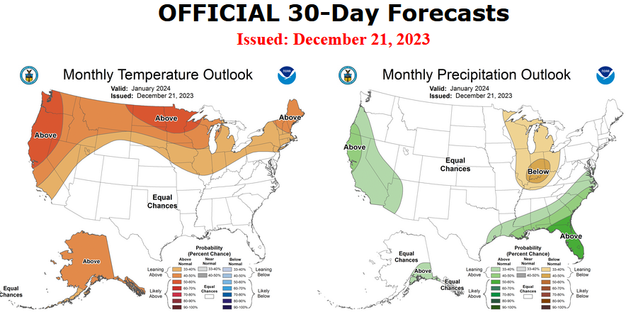
Then I present a graphic that shows both the preliminary Outlook for December and the three-month outlook for DJF 2023-2024. So you get the full picture in one graphic. For some, that may be all they are interested in. Others will be interested in the longer-term predictions and also the rationale supporting the predictions which is mostly provided by the NOAA discussion.
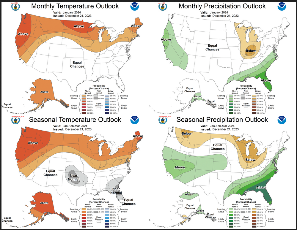
The top row is what is now called the Mid-Month Outlook for next month which will be updated at the end of this month. There is a temperature map and a precipitation map. The second row is a three-month outlook that includes next month. I think the outlook maps are self-explanatory. What is important to remember is that they show deviations from the current definition of normal which is the period 1991 through 2020. So this is not a forecast of the absolute value of temperature or precipitation but the change from what is defined as normal or to use the technical term “climatology”.
| Notice that the outlook for next month and the three-month outlooks are somewhat different, particularly with respect to precipitation. This tells us that February and March will be different than January to some extent. |
The full NOAA Seasonal Outlook extends through January/February/March of 2025. All of these maps are in the body of the article. Large maps are there for January and the three-month period Jan/Feb/Mar. Small maps are provided beyond that through March of 2025 with a link to get larger versions of these maps.
NOAA provides an excellent discussion to support the maps. It is included in the body of this report. In some cases, one will need to click on “read more” to read the full article. For those on my email list where I have sent the url of the article, that will not be necessary.
Short Term and Intermediate-Term Weather Outlooks for the U.S. and a Six-Day Forecast for the World: posted December 22, 2023
This article focuses on what we are paying attention to in the next 48 to 72 hours. The article also includes weather maps for longer-term outlooks and a six-day World weather outlook which can be very useful for travelers.
We start with the U.S. Information. That is the longest part of the article. Then we have a short section on World Weather and then we address the Tropics. When there are tropical storms that might impact the U.S. we provide more detailed information which updates frequently on those storms.
Please click on “Read More” below to access the full report as I have moved the highlights into the body of the report where it is followed by the Today, Tomorrow and the Next Day maps and a lot more. I will try to feature the most important graphic in the lede paragraph on the home page. But there are often multiple maps that are very important so it is best to read the full article. We now have a snow report and it is possible to get a ten-day NWS forecast for the zip code of your choice.
Short Term and Intermediate-Term Weather Outlooks for the U.S. and a Six-Day Forecast for the World: posted December 21, 2023
This article focuses on what we are paying attention to in the next 48 to 72 hours. The article also includes weather maps for longer-term outlooks and a six-day World weather outlook which can be very useful for travelers.
We start with the U.S. Information. That is the longest part of the article. Then we have a short section on World Weather and then we address the Tropics. When there are tropical storms that might impact the U.S. we provide more detailed information which updates frequently on those storms.
Please click on “Read More” below to access the full report as I have moved the highlights into the body of the report where it is followed by the Today, Tomorrow and the Next Day maps and a lot more. I will try to feature the most important graphic in the lede paragraph on the home page. But there are often multiple maps that are very important so it is best to read the full article. We now have a snow report and it is possible to get a ten-day NWS forecast for the zip code of your choice.
Short Term and Intermediate-Term Weather Outlooks for the U.S. and a Six-Day Forecast for the World: posted December 20, 2023
This article focuses on what we are paying attention to in the next 48 to 72 hours. The article also includes weather maps for longer-term outlooks and a six-day World weather outlook which can be very useful for travelers.
We start with the U.S. Information. That is the longest part of the article. Then we have a short section on World Weather and then we address the Tropics. When there are tropical storms that might impact the U.S. we provide more detailed information which updates frequently on those storms.
Please click on “Read More” below to access the full report as I have moved the highlights into the body of the report where it is followed by the Today, Tomorrow and the Next Day maps and a lot more. I will try to feature the most important graphic in the lede paragraph on the home page. But there are often multiple maps that are very important so it is best to read the full article. We now have a snow report and it is possible to get a ten-day NWS forecast for the zip code of your choice.
Looking back at November for the World December 19, 2023 – Earth had its Warmest November Ever Since Reliable Data has been Available.
Most of the information in this report comes from the monthly email I receive from John Bateman. He does public outreach for NOAA and in particular NCEI. I could find the same information and more on the NCEI website but John produces a good summary so I use it or most of it. I also sometimes add additional information from NCEI or other NOAA websites. The full NCEI report for November can be accessed HERE.

I added the below to what John Bateman provided.
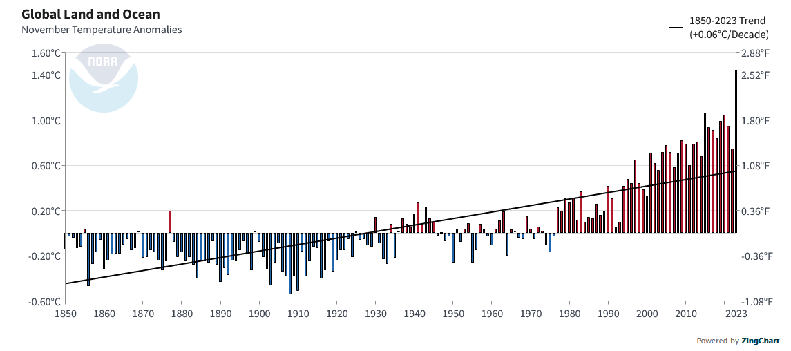
| This November saw a huge jump. Remember this is the data for both land and water. |
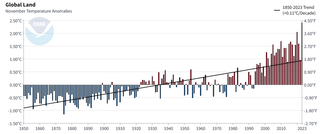
| This looks just at land but the trend is similar. In fact the regression line is even steeper. |
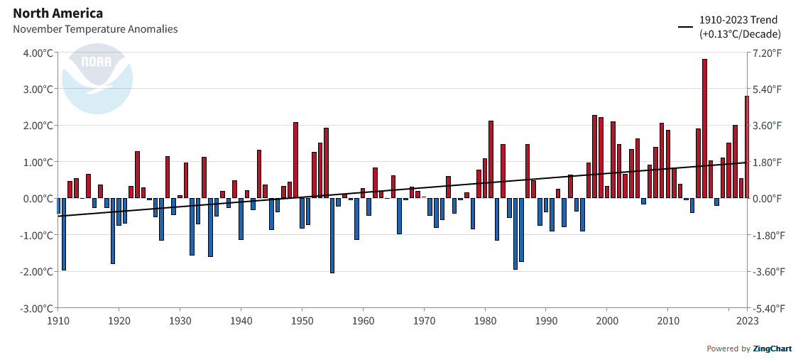
| This is just North America. It is more than just the U.S. and the slope of the regression line is even steeper. But for North America, unlike the world, November did not set a new record. |
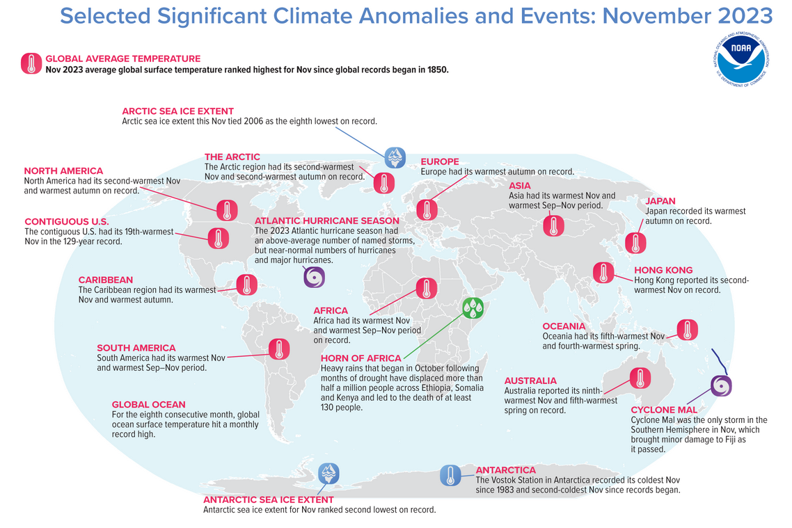
| This shows selected anomalies but it mostly covers temperature around the world. |


