Today Through the Fourth Friday (22 to 28 days) Weather Outlook for the U.S. and a Six-Day Forecast for the World: posted August 2, 2024

This article focuses on what we are paying attention to in the next 48 to 72 hours. The article also includes weather maps for longer-term U.S. outlooks and a six-day World weather outlook which can be very useful for travelers.

First the NWS Short Range Forecast. The afternoon NWS text update can be found here after about 4 p.m. New York time but it is unlikely to have changed very much from the morning update. The images in this article automatically update.

Short Range Forecast Discussion
NWS Weather Prediction Center College Park MD
Fri Aug 02 2024
Valid 12Z Fri Aug 02 2024 – 12Z Sun Aug 04 2024

…A dangerous heat wave will impact much of the East Coast, Southeast and
Northwest through tonight…

…Excessive Rainfall concerns across portions of the Eastern U.S. this
weekend…

…Monsoonal storms continue across the Southwest/Four Corners through the
weekend…

A familiar upper-level pattern over the lower 48, with ridging in the West
and troughing over the Great Lakes and Ohio/Tennessee Valley, will support
heat waves and excessive rainfall concerns this weekend. High temperatures
in the 100s will represent a 10-15 degree positive anomaly across the
Northwest today. Some of these temperatures will tie or break records.
Overnight temperatures in the upper 60s to upper 70s will tie or break
widespread temperature records across the West tonight as well. The
combination of very hot daytime conditions and a lack of overnight relief
could harm those without adequate shelter or hydration. Cloudy conditions
will support near record breaking warmth over portions of the coastal
Northeast and Florida peninsula tonight.

Showers and thunderstorms will develop along a cold front moving through
the Midwest today and spread eastward toward the East Coast. Slight Risks
of Excessive Rainfall leading to Flash Flooding are in effect for portions
of the Lower Great Lakes, Ohio Valley and Northeast today due to the
higher rates within some of the storms that move through those areas.
Orographic lift over portions of the Central/Southern Appalachians will
promote additional Flash Flooding concerns, hence another Slight Risk area
for parts of eastern Tennessee, southeastern Kentucky, southwestern
Virginia, western North Carolina and northern Alabama/Georgia. The cold
front slows down across the Mid-Atlantic/Southeast on Saturday and becomes
the focus for additional Excessive Rainfall concerns, due in part to a
significant moisture plume from the Tropics. A Slight Risk of Excessive
Rainfall is in effect for portions of southeastern Virginia down into the
Carolina/Georgia Piedmont.

A tropical disturbance is forecast to impact the Florida Peninsula
beginning late tonight when heavy rainfall and thunderstorms are supposed
to spread across southern Florida and eventually work their way up the
peninsula on Saturday. A Slight Risk of Excessive Rainfall is in effect
for portions of southern Florida on Saturday as a result. Monsoonal
moisture is expected to continue flowing into the Southwest/Four Corners
region this weekend. Scattered showers and thunderstorms may lead to
isolated Flash Flooding across portions of the aforementioned areas,
particularly burn scars and slot canyons.

To get your local forecast plus active alerts and warnings click HERE and enter your city, state or zip code.

Learn about wave patterns HERE.

Then, looking at the world and of course, the U.S. shows here also. Today we are looking at precipitation.

Please click on “Read More” below to access the full Daily Report issued today.

NOAA Updates its Mid-month Outlook for August, 2024 – There are Some Changes – Posted on August 1, 2024

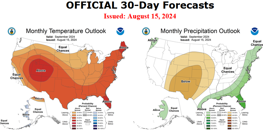
At the end of every month, NOAA updates its Outlook for the following month which in this case is August of 2024. We are reporting on that tonight.

There have been some significant changes in the Outlook for August and these are addressed in the NOAA Discussion so it is well worth reading.  We provided the prior Mid-Month Outlook for August for comparison. It is easy to see the substantial changes in the weather outlook by comparing the Mid-Month and Updated Maps.

The article includes the Drought Outlook for August. NOAA also adjusted the previously issued Seasonal (ASO) Drought Outlook to reflect the changes in the August Drought Outlook. We also provide the Week 2/3 Tropical Outlook for the World.

The best way to understand the updated outlook for August is to view the maps and read the NOAA discussion. I have highlighted the key statements in the NOAA Discussion.

I am going to start with graphics that show the updated Outlook for August and the Mid-Month Outlook for August. This is followed by a graphic that shows both the Updated Outlook for August and the previously issued three-month outlook for ASO 2024. So you get the full picture in three graphics.

Here is the updated Outlook for August 2024.


For Comparison Purposes, Here is the earlier Mid-Month Outlook for August.


It is important to remember that the maps show deviations from the current definition of normal which is the period 1991 through 2020.  So this is not a forecast of the absolute value of temperature or precipitation but the change from what is defined as normal or to use the technical term climatology.

It is a substantial change from what was issued on July 18, 2024. Remember, it is the first set of maps that are the current outlook for August.  One expects some changes  13 days later. However, the changes to the updated August Outlook are significant, particularly with respect to precipitation.  This then gives us some reason to question the (July 18, 2024) three-month ASO temperature and precipitation Outlooks which are shown in the following graphic.

NOAA provided a combination of the Updated Outlook for August and the Three-Month Outlook.

The top pair of maps are again the Updated Outlook for the new month. There is a temperature map and a precipitation map. The bottom row shows the three-month outlooks which includes August the new month. I think the outlook maps are self-explanatory.

To the extent that one can rely on a forecast, we would conclude that September and October will be very different than August, especially for precipitation. You can subtract Augusts from the three-month Outlook and divide by two to get a combined September-October Outlook.

However given the major change in the new August outlook from what was issued on July 18,  2024, we might not trust the Seasonal Outlook issued on July 18, 2024. Something to think about. But the major factor is the projected slower onset of La Nina. Thus this change is consistent with the pattern the NOAA has been predicting although they have been playing catch-up.

Some readers may need to click “Read More” to read the rest of the article.  Some will feel that they have enough information. But there is a lot more information in the rest of this article.

Today Through the Fourth Friday (22 to 28 days) Weather Outlook for the U.S. and a Six-Day Forecast for the World: posted August 1, 2024

This article focuses on what we are paying attention to in the next 48 to 72 hours. The article also includes weather maps for longer-term U.S. outlooks and a six-day World weather outlook which can be very useful for travelers.

First the NWS Short Range Forecast. The afternoon NWS text update can be found here after about 4 p.m. New York time but it is unlikely to have changed very much from the morning update. The images in this article automatically update.

Short Range Forecast Discussion
NWS Weather Prediction Center College Park MD
Thu Aug 01 2024
Valid 12Z Thu Aug 01 2024 – 12Z Sat Aug 03 2024

…Dangerous heat engulfs much of the country as one heatwave continues
from the Southern Plains to the Southeast/Mid-Atlantic and another begins
in the West…

…Severe weather and flash flooding expected for portions of the Midwest
Thursday…

… Locally heavy monsoonal shower and thunderstorm chances continue for
the Southwest…

Widespread, dangerous heat will unfortunately be the main weather story
for much of the country this week as one heatwave continues for the
Plains, Middle/Lower Mississippi Valley, Southeast, and Mid-Atlantic, and
another heatwave begins over portions of the West. A strong upper-level
ridge will remain in place over the southern-tier of the U.S. the next
couple days, allowing for high temperatures to reach into the low 100s
over portions of the Southern Plains/High Plains, the upper 90s to low
100s for the Lower Mississippi Valley, and the upper 90s for the Southeast
into the southern Mid-Atlantic. High humidity values for areas east of the
High Plains will bring heat indices into the 105 to 110 degree range,
potentially as high as 115 for parts of the Lower Mississippi Valley, with
many areas under heat-related advisories or warnings. The combination of
hot temperatures/high heat indices, as well as very warm morning lows only
dropping into the mid- to upper 70s, will be dangerous to anyone without
access to adequate air conditioning. Temperatures warming into the upper
80s/low 90s with periods of higher humidity will lead to some muggy,
potentially dangerous conditions for portions of New England as well,
particularly on Friday. An approaching cold front will bring relief to
northern portions of the Southern Plains and Middle Mississippi Valley on
Friday, with the expectation the heat wave will begin to wane for most
locations through the weekend.

In the West, an upper-level ridge will also begin to build northward,
sending high temperatures across much of the northern tier of the West
10-20 degrees above mid-Summer averages. Forecast highs Thursday are into
the upper 90s/low 100s for the inland Pacific Northwest/northern Great
Basin and mid- to upper 90s for the northern Rockies/High Plains.
Temperatures will get even hotter on Friday, with highs into the low to
mid-100s for most locations. Many near record-tying/breaking highs are
possible. Similar to areas further east, many heat-related advisories and
warnings have been issued as this heat will also reach dangerous levels
for the general public. Smoke from area wildfires will also continue to
plague parts of the region, resulting in hazy conditions and poor air
quality, and the risk for more wildfires will increase as the hot, dry
conditions settle in.

An upper-level low/accompanying surface frontal system traversing the
northern side of the ridge over the southern tier of the U.S. will bring
another round of showers and thunderstorms to the Midwest Thursday. High
surface moisture leading to very strong instability will support intense
thunderstorm development through the afternoon across the warm sector
ahead of an approaching cold front, with lingering outflow boundaries from
overnight convection helping to trigger individual and clusters of storms.
Sufficient shear with the passing upper-level wave will lead to the threat
of severe weather, with a Slight Risk (level 2/5) from the Storm
Prediction Center covering Illinois, Indiana, Kentucky, and southwestern
Ohio, mainly for the threat of some damaging winds. The threat for some
intense downpours given the high moisture/strong storms, and potential for
some more widespread, organized clusters of storms, will lead to some
heavier rainfall totals and the risk for flash flooding. Many of these
locations have seen recent heavy rainfall given repeated rounds of
organized storms passing through, leading to wetter antecedent conditions
more sensitive to any additional rainfall. A Slight Risk of Excessive
Rainfall (level 2/4) covers much of same region from northeastern Illinois
southeast through Indiana/western Ohio and into eastern Kentucky. Some
slow moving storms producing heavy rainfall under the passing upper-low
may also lead to some flash flooding, with the Slight Risk extending
northwest into southern Wisconsin. Some more isolated storms will be
possible further east into the Appalachians and Mid-Atlantic Thursday.
Additional storms will be possible across the region Friday as the system
shifts eastward, with a greater chance of storms spreading into the
Appalachians and the Mid-Atlantic. Some isolated severe storms and
instances of flash flooding will be possible. A lingering upper-level
weakness will lead to scattered showers and thunderstorms over Florida and
portions of the Southeast Thursday, with moderate to locally heavy
rainfall possible, especially over the Florida Peninsula. More widely
scattered storms will remain possible Friday.

Persistent Monsoonal conditions over the Southwest will continue to bring
daily shower and thunderstorm chances. Sufficient moisture across the
region will lead to the threat for some locally heavy downpours and an
isolated flash flooding, particularly over terrain sensitive areas such as
burn scars. A lingering frontal boundary will lead to some storms over
portions of the southern High Plains as well on Thursday, and a subtle
upper-level wave along the edge of the upper-ridging will bring storm
chances northwestward into portions of California Friday, particularly in
vicinity of the Sierra Nevada. Similar to areas further north, forecast
high temperatures more broadly in the region will be trending hotter and
above average, with 90s and low 100s for most locations outside of the
California Coast, and mid-100s to low 110s for the Desert Southwest.

To get your local forecast plus active alerts and warnings click HERE and enter your city, state or zip code.

Learn about wave patterns HERE.

Then, looking at the world and of course, the U.S. shows here also. Today we are looking at precipitation.

Please click on “Read More” below to access the full Daily Report issued today.

Today Through the Fourth Friday (22 to 28 days) Weather Outlook for the U.S. and a Six-Day Forecast for the World: posted July 31, 2024

This article focuses on what we are paying attention to in the next 48 to 72 hours. The article also includes weather maps for longer-term U.S. outlooks and a six-day World weather outlook which can be very useful for travelers.

First the NWS Short Range Forecast. The afternoon NWS text update can be found here after about 4 p.m. New York time but it is unlikely to have changed very much from the morning update. The images in this article automatically update.

Short Range Forecast Discussion
NWS Weather Prediction Center College Park MD
428 PM EDT Tue Jul 30 2024
Valid 00Z Wed Jul 31 2024 – 00Z Fri Aug 02 2024

…There is an Enhanced Risk of severe thunderstorms over parts of the
Central Plains and Middle Mississippi Valley on Tuesday evening and
Wednesday with a Slight Risk of severe thunderstorms over parts of the
Ohio Valley on Thursday…

…There is a Slight Risk of excessive rainfall over parts of the Middle
Mississippi Valley and Ohio/Tennessee Valleys on Tuesday evening and
Wednesday…

…There is a Slight Risk of excessive rainfall over parts of Northern New
England and Southwest on Wednesday and over parts of the Ohio Valley on
Thursday…

…There are Excessive Heat Watches over parts of the Pacific Northwest
and Excessive Heat Warnings/Advisories over parts of the Central/Southern
Plains, Middle/Lower Mississippi Valley, Ohio/Tennessee Valleys, and the
Southeast.

A front with a wave of low pressure over the Northern High Plains will
move slowly eastward to the Ohio Valley/Great Lakes by Thursday. The
associated boundary will aid in triggering showers and severe
thunderstorms over parts of the Central Plains, Middle Mississippi Valley,
and parts of the Ohio/Tennessee Valleys. Therefore, the SPC has issued an
Enhanced Risk (level 3/5) of severe thunderstorms over the Central Plains
and Middle Mississippi Valley through Wednesday morning. The hazards
associated with these thunderstorms are frequent lightning, severe
thunderstorm wind gusts, hail, and a few tornadoes. Also, there is a
threat of severe thunderstorm wind gust of 65 knots, or greater over parts
of the Central Plains, Middle Mississippi Valley and hail two inches, or
greater over parts of the Central Plains.

In addition, showers and thunderstorms will create heavy rain over parts
of the Middle Mississippi Valley and Ohio/Tennessee Valleys. Therefore,
the WPC has issued a Slight Risk (level 2/4) of excessive rainfall over
parts of the Middle Mississippi Valley and Ohio/Tennessee Valleys through
Wednesday morning. The associated heavy rain will create mainly localized
areas of flash flooding, with urban areas, roads, small streams, and
low-lying areas the most vulnerable.

A second area of severe thunderstorms is forecast over parts of the
Northern Plains. Therefore, the SPC has issued a Slight Risk (level 2/5)
of severe thunderstorms over parts of the Northern Plains through
Wednesday morning. The hazards associated with these thunderstorms are
frequent lightning, severe thunderstorm wind gusts, hail, and a few
tornadoes.

As the wave of low-pressure moves eastward overnight Tuesday into
Wednesday, the system will create showers and severe thunderstorms over
parts of the Middle Mississippi Valley. Therefore, the SPC has issued an
Enhanced Risk (level 3/5) of severe thunderstorms over the Middle
Mississippi Valley from Wednesday through Thursday morning. The hazards
associated with these thunderstorms are frequent lightning, severe
thunderstorm wind gusts, hail, and a few tornadoes. Moreover, there is an
increased threat of severe thunderstorms wind gust of 65 knots or greater
over parts of the Central/Southern Plains and Upper/Middle Mississippi
Valley. Additionally, there is a threat of hail two inches or greater over
parts of the Northern/Central Plains and Upper Mississippi Valley.

Furthermore, showers and thunderstorms will produce heavy rain over parts
of the Northern Plains, Upper/Middle Mississippi Valley, and Ohio Valley.
Therefore, the WPC has issued a Slight Risk (level 2/4) of excessive
rainfall over parts of these areas from Wednesday through Thursday
morning. The associated heavy rain will create mainly localized areas of
flash flooding, with urban areas, roads, small streams, and low-lying
areas the most vulnerable.

Moreover, upper-level energy and a plume of moisture moving over New
England will produce areas of heavy rain. Therefore, the WPC has issued a
Slight Risk (level 2/4) of excessive rainfall over parts of Northern New
England from Wednesday through Thursday morning. The associated heavy
rain will create mainly localized areas of flash flooding, with urban
areas, roads, small streams, and low-lying areas the most vulnerable.

Similarly, upper-level energy and a plume of moisture will create areas of
heavy rain over parts of the Southwest. Therefore, the WPC has issued a
Slight Risk (level 2/4) of excessive rainfall over parts of the Southwest
from Wednesday through Thursday morning. The associated heavy rain will
create mainly localized areas of flash flooding, with urban areas, roads,
small streams, and low-lying areas the most vulnerable.

On Thursday, the wave of low pressure continues to move eastward,
producing showers and severe thunderstorms over parts of the Ohio Valley.
Therefore, on Thursday, the SPC issued a Slight Risk (level 2/5) of severe
thunderstorms over parts of the Ohio Valley. The hazards associated with
these thunderstorms are frequent lightning, severe thunderstorm wind
gusts, hail, and a few tornadoes.

Likewise, the showers and thunderstorms will create heavy rain over parts
of the Ohio Valley/Great Lakes. Therefore, the WPC has issued a Slight
Risk (level 2/4) of excessive rainfall over parts of the Ohio Valley/Great
Lakes on Thursday. The associated heavy rain will create mainly localized
areas of flash flooding, with urban areas, roads, small streams, and
low-lying areas the most vulnerable.

Meanwhile, upper-level ridging will build over the Pacific Northwest,
spawning Excessive Heat Watches over parts of the region. The upper-level
ridging will aid in creating intense and widespread heat across portions
of the West late this week. High temperatures 10-15 degrees above normal
are expected across the Northwest and Northern High Plains later this
week, where several daily record high temperatures are forecast.

Moreover, the upper-level high will develop over the central portion of
the country, which will foster Excessive Heat Warnings/ Heat Advisories
over parts of the Central/Southern Plains, Middle/Lower Mississippi
Valley, Ohio/Tennessee Valleys, and the Southeast. The associated
dangerous heat, with high temperatures exceeding 100F and heat indices
near 110F, persists over the South-Central Plains and Mid-South through
Thursday. Multiple days of Major to Extreme HeatRisk are forecast for
portions of the southern Plains to the Southeast. These levels of heat
mean health impacts become more likely in general, and may occur in ANYONE
without adequate hydration or cooling

To get your local forecast plus active alerts and warnings click HERE and enter your city, state or zip code.

Learn about wave patterns HERE.

Then, looking at the world and of course, the U.S. shows here also. Today we are looking at precipitation.

Please click on “Read More” below to access the full Daily Report issued today.

Today Through the Fourth Friday (22 to 28 days) Weather Outlook for the U.S. and a Six-Day Forecast for the World: posted July 30, 2024

This article focuses on what we are paying attention to in the next 48 to 72 hours. The article also includes weather maps for longer-term U.S. outlooks and a six-day World weather outlook which can be very useful for travelers.

First the NWS Short Range Forecast. The afternoon NWS text update can be found here after about 4 p.m. New York time but it is unlikely to have changed very much from the morning update. The images in this article automatically update.

Short Range Forecast Discussion
NWS Weather Prediction Center College Park MD
Tue Jul 30 2024
Valid 12Z Tue Jul 30 2024 – 12Z Thu Aug 01 2024

…Daily scattered flash flooding and severe weather from the Mid-Atlantic
into the Northern Plains/Midwest…

…Dangerous mid-summer heat wave to expand across the Central U.S. and
Southeast; more hot weather across the West…

An active, unsettled pattern will continue across the eastern half of the
Lower 48 as an elongated frontal system with access to abundant moisture
and instability leads to repeat bouts of thunderstorms through midweek.
This will maintain a daily threat of scattered (level 2/5) flash flooding
and severe weather from the Mid-Atlantic, Ohio/Tennessee Valley, Midwest,
and Northern Plains through Thursday. Daily isolated flash flooding
chances should also continue across the Southwest tied to the monsoon.

Thunderstorms aside, heat will become the big story over the Central and
Southeast U.S. this week as an upper-level high strengthens. Forecast high
temperatures Monday and Tuesday are expected to soar into the triple
digits over the Central Plains, with upper-90s to low 100s to the west
over much of the High Plains, and mid-to upper 90s for the Middle and
Lower Mississippi Valley. High humidity values over the Mississippi Valley
and eastern portions of the plains will lead to heat indices in the
105-110 degree range, potentially as high as 115 for some locations, with
widespread Excessive Heat Warnings and Advisories in place. Warm morning
lows only dropping into the mid- to upper 70s will provide little relief
from the heat overnight. This combination of hotter temperatures to the
west, higher heat indices to the east, and the multi-day duration of this
heat wave will increase the danger not only to more sensitive groups, but
also the general public, particularly those without adequate air
conditioning.

West of the Continental Divide, a troughing pattern and associated cool
weather over the West will give way to widespread warm weather by Thursday
as a stationary Pacific front washes away beneath widespread height rises
across the region. By Friday, we can expect high temperatures in the 90’s
and triple digits across much of the West which could challenge numerous
records across the region. Unfortunately, smoke from area wildfires will
also continue to plague parts of the West, particularly over portions of
the northern Great Basin, resulting in poor air quality and areas of
reduced visibility.

To get your local forecast plus active alerts and warnings click HERE and enter your city, state or zip code.

Learn about wave patterns HERE.

Then, looking at the world and of course, the U.S. shows here also. Today we are looking at precipitation.

Please click on “Read More” below to access the full Daily Report issued today.

Today Through the Fourth Friday (22 to 28 days) Weather Outlook for the U.S. and a Six-Day Forecast for the World: posted July 29, 2024

This article focuses on what we are paying attention to in the next 48 to 72 hours. The article also includes weather maps for longer-term U.S. outlooks and a six-day World weather outlook which can be very useful for travelers.

First the NWS Short Range Forecast. The afternoon NWS text update can be found here after about 4 p.m. New York time but it is unlikely to have changed very much from the morning update. The images in this article automatically update.

Short Range Forecast Discussion
NWS Weather Prediction Center College Park MD
Mon Jul 29 2024
Valid 12Z Mon Jul 29 2024 – 12Z Wed Jul 31 2024

…Flash flooding possible in the Ohio/Tennessee Valleys and
central/southern Appalachians through early this week…

…Scattered severe thunderstorms forecast across portions of the Northern
Plains Monday and Upper Midwest Tuesday…

…Dangerous mid-summer heat wave to begin expanding across the central
U.S. on Monday…

Bouts of thunderstorms are expected to continue over portions of the
Ohio/Tennessee Valleys and spread further into the central/southern
Appalachians to start off the work week. An active upper-level pattern
featuring at least a couple shortwaves and an approaching surface frontal
system from the west will help to focus storm development over the
Ohio/Tennessee Valleys and eventually into the southern Appalachians
Monday. Plentiful moisture in place will also continue to lead to the
threat of heavier rain rates, with increasing storm coverage into the
evening and potential back building/repeated rounds of storms raising the
chance for locally heavy rainfall totals. As such, a Slight Risk of
Excessive Rainfall (level 2/4) is in place for the threat of some
scattered flash flooding. In addition, sufficient instability/shear will
be in place over the Ohio Valley for a couple more intense storms, as well
as the threat for a more organized storm complex later Monday evening. The
Storm Prediction Center has included a Slight Risk (level 2/5) for severe
weather as well mainly for the threat of damaging winds. A similar pattern
will be in place on Tuesday, with the focus shifting further into the
southern and central Appalachians as the upper-level energy and surface
frontal system move eastward. Another Slight Risk of Exessive Rainfall is
in effect here for additional instances of flash flooding. Outside of the
flash flooding threat, scattered thunderstorms with moderate to locally
heavy rainfall are expected more broadly over the Midwest/Southeast
Monday, and also over portions of New England as a coastal low approaches.
Rain chances will expand over the Mid-Atlantic/Northeast as the system
approaches from the west on Tuesday. Forecast high temperatures across the
East will vary depending on cloud/storm coverage, with mostly mid-80s to
low 90s expected.

Some additional storms will be possible further west along the frontal
boundary into the Upper Midwest and Northern Plains. Embedded upper-level
energy will help to trigger one round of storms over the Northern Plains
on Monday. Stronger upper-level flow will lead to more deep-layer shear
here than further east, with another Slight Risk of severe weather for the
threat of some very large hail as well as significant damaging winds if
storms consolidate/grow upscale into an organized system later in the
evening. Another round of severe weather is possible downstream over the
Upper Midwest Tuesday as yet another upper-level impulse helps to trigger
storms along the frontal boundary. Very high moisture will lead to strong
to extreme instability, with a Slight Risk in place for the chance of more
damaging winds.

Outside of the severe weather threat, heat will become the big story more
broadly over the central U.S. over the next few days as an upper-level
high strengthens/expands over the region. Forecast high temperatures
Monday and Tuesday are expected to soar into the low to mid-100s over the
Central Plains, with upper-90s to low 100s to the west over much of the
High Plains, and mid- to upper 90s for the Middle and Lower Mississippi
Valley. High humidity values over the Mississippi Valley and eastern
portions of the plains will lead to heat indices in the 105-110 degree
range, potentially as high as 115 for some locations, with widespread
heat-related warnings/advisories in place. Warm morning lows only dropping
into the mid- to upper 70s will provide little relief from the heat
overnight. This combination of hotter temperatures to the west, higher
heat indices to the east, and the multi-day duration of this heat wave
will increase the danger not only to more sensitive groups, but also the
general public, particularly those without adequate air conditioning.

A stagnant troughing pattern over the West will keep temperatures mostly
below average across the region, especially over portions of the Pacific
Northwest and northern Great Basin/Rockies. Forecast highs Monday-Tuesday
range between the 60s and 70s along the Pacific Coast, the 70s and 80s in
the Pacific Northwest and northern Great Basin/Rockies, the 80s and 90s
for interior California and the central Great Basin/Four Corners Region,
and 100s in the Desert Southwest. A cold front passing through the Pacific
Northwest will bring some rain chances on Monday, spreading into the
northern Rockies Tuesday. Smoke from area wildfires will also continue to
plague parts of the West, particularly over portions of the northern Great
Basin, resulting in poor air quality and areas of reduced visibility.

To get your local forecast plus active alerts and warnings click HERE and enter your city, state or zip code.

Learn about wave patterns HERE.

Then, looking at the world and of course, the U.S. shows here also. Today we are looking at precipitation.

Please click on “Read More” below to access the full Daily Report issued today.

Today Through the Fourth Friday (22 to 28 days) Weather Outlook for the U.S. and a Six-Day Forecast for the World: posted July 28, 2024

This article focuses on what we are paying attention to in the next 48 to 72 hours. The article also includes weather maps for longer-term U.S. outlooks and a six-day World weather outlook which can be very useful for travelers.

First the NWS Short Range Forecast. The afternoon NWS text update can be found here after about 4 p.m. New York time but it is unlikely to have changed very much from the morning update. The images in this article automatically update.

Short Range Forecast Discussion
NWS Weather Prediction Center College Park MD
Sun Jul 28 2024
Valid 12Z Sun Jul 28 2024 – 12Z Tue Jul 30 2024

…Flash flooding possible in the Ohio/Tennessee Valleys Sunday, spreading
into the central/southern Appalachians by Monday…

…Severe thunderstorms expected across portions of the Northern/Central
Plains with flash flooding into the Upper Midwest Sunday…

…Cooler than normal for much of the West with monsoonal thunderstorms
for portions of the Southwest…

A lingering frontal boundary snaking through the Ohio/Tennessee Valleys
deeper into the Southeast and off the Atlantic coast will continue to help
trigger scattered showers and thunderstorms over the next couple of days.
An upper-level wave passing over the Ohio/Tennessee Valleys will provide a
focus for more numerous storms on Sunday, possibly into the
central/southern Appalachians as well, with very moist, southerly Gulf
flow leading to some locally heavy downpours. A Slight Risk of Excessive
Rainfall (level 2/4) is in effect for the threat of some scattered
instances of flash flooding, particularly where storms may have the
tendency to backbuild/repeat over areas in vicinity of the frontal
boundary. Then, as the upper-level wave continues east on Monday, the
focus for storms will spread further into the central/southern
Appalachians, with another Slight Risk of Excessive Rainfall in effect for
additional instances of flash flooding. High temperatures broadly across
the Ohio Valley into the Southeast and along the Gulf Coast will remain at
or a bit below average given widespread clouds and storms, with highs
generally in the mid-80s to low 90s.

A frontal system passing slowly through the Northern/Central Plains and
the Upper Midwest will bring storm chances to these regions Sunday.
Plentiful moisture, instability, and strong upper-level flow overhead
leading to sufficient deep-layer shear is expected to result in some more
intense, organized storms. Initially isolated storms/supercells over
portions of South Dakota, central Nebraska, and northwestern Kansas may
produce some large hail and damaging winds. Eventual upscale growth into
an organized convective system Sunday evening may bring a damaging wind
threat downstream into southwestern Minnesota and northwestern Iowa. The
Storm Prediction Center has highlighted these areas with a Slight Risk
(level 2/5) of severe weather. The expanding coverage of storms heading
eastward, as well as plentiful moisture to lead to heavy rainfall rates,
will also bring the threat of flash flooding into Iowa. Additional storms
will continue ahead of the front over Minnesota through early morning
Sunday, with another round of storms expected Sunday night. Repeated
storms bringing heavy rainfall on top of already wet antecedent conditions
will lead to the risk of some scattered flash flooding here as well. A
Slight Risk of Excessive Rainfall extends from portions of Minnesota
southward into Iowa to cover these threats. The system will continue into
the Great Lakes region Monday, bringing showers and storms with moderate
to locally heavy rainfall. High temperatures ahead of the front will be
rather hot, running 10-15 degrees above average for some locations, with
80s to near 90 in the Upper Midwest and 90s to low 100s southwestward into
the Central Plains and southern High Plains. A few near
record-tying/breaking highs will be possible in the southern High Plains
Monday.

An upper-trough over the West will keep temperatures below average for
most of the region. Forecast highs Sunday-Monday range between the 60s and
70s along the Pacific Coast; 70s and 80s in the Pacific Northwest; 80s and
90s in the Great Basin, Four Corners Region, and interior California; and
the 100s into the Desert Southwest. Some Monsoonal storms will continue
over parts of the Southwest, particularly southeastern
Arizona/southwestern New Mexico, with an isolated threat of flash
flooding. A storm system approaching the Pacific Northwest will bring some
shower chances here as well. Smoke from wildfires will also continue to
plague parts of the West, particularly over the northern Great
Basin/Rockies, resulting in poor air quality and areas of reduced
visibility. Elsewhere, conditions will be trending hotter across most of
the Northeast, with 80s and low 90s forecast. A coastal low approaching
southern New England is looking more likely to bring cooler temperatures
and some rain chances over the next couple of days.

To get your local forecast plus active alerts and warnings click HERE and enter your city, state or zip code.

Learn about wave patterns HERE.

Then, looking at the world and of course, the U.S. shows here also. Today we are looking at precipitation.

Please click on “Read More” below to access the full Daily Report issued today.

Today Through the Fourth Friday (22 to 28 days) Weather Outlook for the U.S. and a Six-Day Forecast for the World: posted July 27, 2024

This article focuses on what we are paying attention to in the next 48 to 72 hours. The article also includes weather maps for longer-term U.S. outlooks and a six-day World weather outlook which can be very useful for travelers.

First the NWS Short Range Forecast. The afternoon NWS text update can be found here after about 4 p.m. New York time but it is unlikely to have changed very much from the morning update. The images in this article automatically update.

Short Range Forecast Discussion
NWS Weather Prediction Center College Park MD
Sat Jul 27 2024
Valid 12Z Sat Jul 27 2024 – 12Z Mon Jul 29 2024

…Scattered showers and thunderstorms continue across portions of the
South and Mississippi Valley this weekend with the risk for some flash
flooding…

…Hot weather is in store across portions of the Northern Plains and
Upper Midwest ahead of a cold front bringing the threat of severe
thunderstorms on Saturday and heavy downpours on Sunday…

…Monsoonal thunderstorms continue for portions of the Intermountain West
with isolated flash flooding possible…

Scattered showers and thunderstorms will continue across portions of the
South and Mississippi Valley this weekend in the presence of very moist,
southerly Gulf flow. An upper-level wave over the Plains on Saturday will
encourage storms over the Middle and Lower Mississippi Valley and along
the Gulf Coast. A Slight Risk of Excessive Rainfall (level 2/4) is in
effect for portions of the Gulf Coast of Texas where recent heavy rainfall
over the past few days has left wetter antecedent conditions more
susceptible to scattered instances of flash flooding, though an isolated
flash flood risk will exist elsewhere. The wave will move eastward on
Sunday, helping to focus storm development over portions of the Middle
Mississippi/Lower Ohio Valley southeastward into the Tennessee Valley and
south to the Gulf Coast. The greatest concentration of storms/storm
clusters is expected along the leading edge of the wave over the Tennessee
Valley, where a Slight Risk of Excessive rainfall is in place for another
threat of some scattered flash flooding. The unsettled weather will help
keep temperatures down across the region this weekend, with temperatures
at or below Summer-time averages, especially for portions of central and
eastern Texas. Forecast highs are generally in the mid- to upper 80s, with
low 90s possible closer to the central Gulf/Atlantic coasts and into
Florida.

To the north, a slow moving frontal system will bring shower and storm
chances to the Northern Plains/Upper Midwest Saturday. Plentiful moisture
with sufficient instability, as well as stronger upper-level flow arriving
over the region helping to strengthen deep-layer shear, will promote some
more intense thunderstorms. The Storm Prediction Center has issued a
Slight Risk of severe weather (level 2/5) over portions of eastern North
Dakota into northwestern Minnesota for the threat of large hail and
damaging winds. Some isolated flash flooding will also be possible. Then,
on Sunday, the front is expected to slow as it approaches Minnesota.
Increasing storm coverage along the front will lead to a greater chance of
heavier rain totals and flash flooding, with a Slight Risk of Excessive
rainfall over northern Minnesota. Further to the southwest, more isolated
storms ahead of the front over central South Dakota will continue to pose
a threat of severe weather, with a Slight Risk in place for some large
hail and damaging winds. Forecast highs ahead of the front will continue
to remain well above average, with highs in the mid-80s to low 90s for the
Northern Plains/Upper Midwest and mid- to upper 90s into the Central
Plains.

More Monsoonal storms are expected on Saturday across portions of the
Great Basin, Rockies, and Southwest. Lingering moisture across the region
may lead to some locally heavy downpours, with isolated flash flooding
possible, particularly for terrain sensitive areas such as burn scars.
Storm chances will come down as upper-level heights begin to rise over the
region on Sunday, with a lingering chance over southeastern
Arizona/southwestern New Mexico. Forecast highs broadly across the West
will be at or a bit below average with an upper-level trough in place.
Highs will be in the 60s and 70s along the Pacific Coast, the 70s and 80s
for the Pacific Northwest, the 80s and 90s for interior California and the
Great Basin/Rockies, and 100s in the Desert Southwest.

Elsewhere, conditions will be rather tranquil from the Great Lakes east to
the East Coast between weather systems. Some showers may begin to spread
into the Great Lakes region later Sunday as the Plains system approaches
from the west, while a coastal low could bring some showers to southern
New England. Forecast highs will generally be at or above average, with
highs in the mid- to upper 80s.

To get your local forecast plus active alerts and warnings click HERE and enter your city, state or zip code.

Learn about wave patterns HERE.

Then, looking at the world and of course, the U.S. shows here also. Today we are looking at precipitation.

Please click on “Read More” below to access the full Daily Report issued today.

Today Through the Fourth Friday (22 to 28 days) Weather Outlook for the U.S. and a Six-Day Forecast for the World: posted July 26, 2024

This article focuses on what we are paying attention to in the next 48 to 72 hours. The article also includes weather maps for longer-term U.S. outlooks and a six-day World weather outlook which can be very useful for travelers.

First the NWS Short Range Forecast. The afternoon NWS text update can be found here after about 4 p.m. New York time but it is unlikely to have changed very much from the morning update. The images in this article automatically update.

Short Range Forecast Discussion
NWS Weather Prediction Center College Park MD
Fri Jul 26 2024
Valid 12Z Fri Jul 26 2024 – 12Z Sun Jul 28 2024

…Scattered showers and thunderstorms continue across much of the South
with a risk for flash flooding Friday in the coastal Carolinas and
southeastern Texas…

…Storm chances for portions of the Upper Midwest and Northern Plains
heading into the weekend with severe weather possible Saturday…

…Monsoonal thunderstorms continue for portions of the Intermountain West
with isolated flash flooding possible…

Scattered showers and thunderstorms will continue across much of the South
along and ahead of a cold front slowly pushing southward through the
region. Plentiful moisture will bring the threat of some locally heavy
downpours. A couple upper-level waves, one over the Carolinas and another
to the west over the Southern Plains, will help to provide a focus for
some locally more widespread, intense downpours along the coastal
Carolinas and southeastern Texas. Wet antecedent conditions from rainfall
the past few days will increase the risk for some scattered flash
flooding, with Slight Risks of Excessive Rainfall (level 2/4) in place. An
isolated threat for flash flooding will exist more broadly across the
region both Friday and Saturday. The presence of storms and general
cloudiness will help to keep temperatures near or below Summer-time
averages, especially over portions of eastern and central Texas, with
highs generally in the 80s.

A frontal boundary draped across the Upper Midwest/Northern Plains will be
the focus for daily thunderstorm chances heading into the weekend. More
widely scattered storms are expected Friday before a passing upper-level
shortwave helps to encourage more widespread storms on Saturday.
Sufficient instability along with the arrival of stronger winds aloft
bringing increasing deep-layer shear is expected to result in at least a
few more intense thunderstorms. The Storm Prediction Center has issued a
Slight Risk of severe weather (level 2/5) for portions of northwestern
Minnesota and eastern North Dakota for the threat of some large hail as
well as damaging winds, particularly if storms can organize into a
convective system into the evening hours. High temperatures will remain
rather hot across the Northern/Central Plains and Upper Midwest, with
highs in the 90s upwards of 10-15 degrees above average.

Monsoonal showers will continue across portions of the Intermountain West
Friday and Saturday, particularly from the Southwest north through the
Rockies and central Great Basin. Deep moisture lingering through the area
will bring the threat for some locally intense downpours. Isolated
instances of flash flooding will remain possible, particularly for terrain
sensitive areas such as burn scars. Forecast highs across the West will
generally be below average with an upper-level trough overhead, with highs
in the 80s and 90s across the Pacific Northwest, Great Basin, Rockies, and
interior California, and 60s and 70s along the Pacific Coast. The Desert
Southwest will be much hotter, with highs in the low to mid-110s.
Elsewhere, conditions will be mostly dry from the Midwest to the Northeast
under the presence of high pressure. Forecast high temperatures Friday
will be a bit below average, with low to mid-80s forecast. Highs will warm
up a bit on Saturday, reaching into the mid- to upper 80s.

To get your local forecast plus active alerts and warnings click HERE and enter your city, state or zip code.

Learn about wave patterns HERE.

Then, looking at the world and of course, the U.S. shows here also. Today we are looking at precipitation.

Please click on “Read More” below to access the full Daily Report issued today.

Today Through the Fourth Friday (22 to 28 days) Weather Outlook for the U.S. and a Six-Day Forecast for the World: posted July 25, 2024

This article focuses on what we are paying attention to in the next 48 to 72 hours. The article also includes weather maps for longer-term U.S. outlooks and a six-day World weather outlook which can be very useful for travelers.

First the NWS Short Range Forecast. The afternoon NWS text update can be found here after about 4 p.m. New York time but it is unlikely to have changed very much from the morning update. The images in this article automatically update.

Short Range Forecast Discussion
NWS Weather Prediction Center College Park MD
Thu Jul 25 2024
Valid 12Z Thu Jul 25 2024 – 12Z Sat Jul 27 2024

…Another day of major to locally extreme Heat Risk across the northern
High Plains before cooler air arrives behind a cold front…

…Excessive Rainfall is forecast for the Texas coast through tonight with
more scattered showers and thunderstorms across the southern tier states
to the East Coast…

…Monsoonal thunderstorms continue across the Great Basin and into the
Four Corners region with threats of localized flash flooding while fire
weather danger emerges over the interior Northwest…

A slow-to-evolve summertime weather pattern will continue across much of
the U.S. mainland while a more progressive Pacific cold front sweeps
across the northwestern part of the country through the next couple of
days. Under this weather pattern, unsettled weather and relatively cool
temperatures for July will continue across the South as well as the Great
Lakes. The stronger forcing associated with the Pacific front will push
the heat dome into the northern High Plains today behind a warm front,
resulting in another day of major to locally extreme Heat Risk for the
region. High temperatures will once again reach well up into the 100s with
little to no rainfall expected. Meanwhile, the heat will continue to
become less intense over the Central Valley of California and the Desert
Southwest. Some of the hot air over the northern Plains will be pushed
into the upper Midwest by the weekend with highs reaching into the 80s and
90s. Please continue to practice heat safety before cooler air arrives
behind the cold front.

The Pacific cold front currently making its way through the northern
Rockies into the High Plains will gradually become nearly stationary
through the next couple of days. Lightning associated with dry
thunderstorms triggered by the passage of the cold front will raise fire
danger concerns over the interior northwestern U.S. into the northern High
Plains. Farther south, monsoonal thunderstorms across the Great Basin
today will shift farther eastward into the Four Corners and as far north
as Wyoming through the next couple of days.

In contrast to the heat in the West, cooler than normal temperatures will
prevail across the mid-section of the country and portions of the eastern
U.S. where a stalled front will keep plenty of clouds along with scattered
thunderstorms. It appears that coastal sections of Texas will see the
highest chance of receiving heavy rainfall today into tonight as some
influx of tropical moisture from the Gulf of Mexico could interact with
the weak front under a broad upper-level southwesterly flow ahead of a
trough. A moderate risk of excessive rainfall remains in place from the
mid and upper Texas coast to southwestern Louisiana through tonight.
Thunderstorms across other areas of the southern tier states are not
expected to be severe, but they could result in localized flooding issues
from time to time. The same is true along the East Coast with a slight
risk of excessive rainfall over portions of the Carolinas through Friday
night where storms are expected to be more numerous. Meanwhile, showers
and a few embedded thunderstorms today across New England will clear out
by Friday as a low pressure wave moves away into eastern Canada.

To get your local forecast plus active alerts and warnings click HERE and enter your city, state or zip code.

Learn about wave patterns HERE.

Then, looking at the world and of course, the U.S. shows here also. Today we are looking at precipitation.

Please click on “Read More” below to access the full Daily Report issued today.