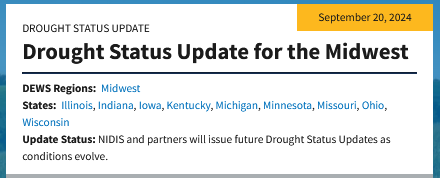
Short Range Forecast Discussion
NWS Weather Prediction Center College Park MD
Fri Sep 27 2024
Valid 12Z Fri Sep 27 2024 - 12Z Sun Sep 29 2024

...HELENE is forecast to continue to move inland to the northwestward to
the Ohio Valley by Saturday while slowly weakening...

...There is a High Risk of excessive rainfall over parts of the Southern
Appalachians on Friday and a Slight Risk over parts of the Ohio Valley on
Saturday...

...There is an Enhanced Risk of severe thunderstorms over parts of the
southern Mid-Atlantic on Friday...

...There are Excessive Heat Warnings over parts of Southeastern California
and the Southwest...

HELENE is forecast to move inland, heading northwestward to the Ohio
Valley, and slowly weaken by Saturday. Showers and thunderstorms with
heavy rain will develop over parts of the Southern Appalachians and
southern Mid-Atlantic. Therefore, the WPC has issued a High Risk (level
4/4) of excessive rainfall over the Southern Appalachians through Saturday
morning.  Severe, widespread flash flooding is expected. In addition,
areas that normally do not experience flash flooding will flood. Lives and
property are in great danger.

Moreover, showers and severe thunderstorms will develop over parts of the
southern Mid-Atlantic. Therefore, the SPC has issued an Enhanced Risk
(level 3/5) of severe thunderstorms over the southern Mid-Atlantic through
Saturday morning.  The hazards associated with these thunderstorms are
frequent lightning, a few tornadoes, and a minimal threat of severe
thunderstorm wind gusts and hail. Also, rain will develop over parts of
the Ohio/Tennessee Valleys on Friday.

On Saturday, the excessive rainfall threat from HELENE lessens. However,
heavy rain will develop over parts of the Ohio Valley. Therefore, the WPC
has issued a Slight Risk (level 2/4) of excessive rainfall over parts of
the Ohio Valley from Saturday through Sunday morning. The associated heavy
rain will create mainly localized areas of flash flooding, with urban
areas, roads, small streams, and low-lying areas the most vulnerable.

Further, the threat of severe thunderstorms ends on Saturday. Yet showers
and thunderstorms will develop over the Florida Peninsula. Additionally,
rain will continue over the Ohio/Tennessee Valleys and parts of the
Mid-Atlantic through Sunday morning.

Meanwhile, a front will move onshore over the Pacific Northwest and inland
to the Northern Plains. The system will produce rain over parts of the
Northwest ending by late Friday afternoon.

In addition, an upper-level high will remain over the Southwest through
Sunday. High temperatures will range from the upper 90s to 110s, and low
temperatures in the mid to upper 80s will provide little relief from the
heat overnight. The temperatures have prompted Excessive Heat Warnings
over parts of Southeastern California and the Southwest.
alid 12Z Fri Sep 27 2024 - 12Z Sun Sep 29 2024 ...HELENE is forecast to continue to move inland to the northwestward to the Ohio Valley by Saturday while slowly weakening... ...There is a High Risk of excessive rainfall over parts of the Southern Appalachians on Friday and a Slight Risk over parts of the Ohio Valley on Saturday... ...There is an Enhanced Risk of severe thunderstorms over parts of the southern Mid-Atlantic on Friday... �There are Excessive Heat Warnings over parts of Southeastern California and the Southwest� HELENE is forecast to move inland, heading northwestward to the Ohio Valley, and slowly weaken by Saturday. Showers and thunderstorms with heavy rain will develop over parts of the Southern Appalachians and southern Mid-Atlantic. Therefore, the WPC has issued a High Risk (level 4/4) of excessive rainfall over the Southern Appalachians through Saturday morning. Severe, widespread flash flooding is expected. In addition, areas that normally do not experience flash flooding will flood. Lives and property are in great danger. Moreover, showers and severe thunderstorms will develop over parts of the southern Mid-Atlantic. Therefore, the SPC has issued an Enhanced Risk (level 3/5) of severe thunderstorms over the southern Mid-Atlantic through Saturday morning. The hazards associated with these thunderstorms are frequent lightning, a few tornadoes, and a minimal threat of severe thunderstorm wind gusts and hail. Also, rain will develop over parts of the Ohio/Tennessee Valleys on Friday. On Saturday, the excessive rainfall threat from HELENE lessens. However, heavy rain will develop over parts of the Ohio Valley. Therefore, the WPC has issued a Slight Risk (level 2/4) of excessive rainfall over parts of the Ohio Valley from Saturday through Sunday morning. The associated heavy rain will create mainly localized areas of flash flooding, with urban areas, roads, small streams, and low-lying areas the most vulnerable. Further, the threat of severe thunderstorms ends on Saturday. Yet showers and thunderstorms will develop over the Florida Peninsula. Additionally, rain will continue over the Ohio/Tennessee Valleys and parts of the Mid-Atlantic through Sunday morning. Meanwhile, a front will move onshore over the Pacific Northwest and inland to the Northern Plains. The system will produce rain over parts of the Northwest ending by late Friday afternoon. In addition, an upper-level high will remain over the Southwest through Sunday. High temperatures will range from the upper 90s to 110s, and low temperatures in the mid to upper 80s will provide little relief from the heat overnight. The temperatures have prompted Excessive Heat Warnings over parts of Southeastern California and the Southwest.