NOAA Updates its ENSO Alert on September 12, 2024 – We Remain in ENSO Neutral – Published September 14, 2024

“Synopsis: ” A weaker La Niña implies that it would be less likely to result in conventional winter impacts, though predictable signals could still influence the forecast guidance”  

So we are really in ENSO Neutral but NOAA may not want to admit their forecast was wrong so they present it as waiting for La Nina. It is correct that we are in La Nina Watch but it is also correct that we currently remain in ENSO Neutral.

On the second Thursday of every month, NOAA (really their Climate Prediction Center CPC) issues its analysis of the status of ENSO. This includes determining the Alert System Status.  NOAA now describes their conclusion as “ENSO Alert System Status: La Nino Watch”

The exact timing of the transition is now perhaps more clear which should increase the reliability of the Seasonal Outlook to be issued next Thursday.

We have included an ENSO Blog article by Emily  Becker.

CLIMATE PREDICTION CENTER ENSO DISCUSSION (LINK)


The second paragraph is what is important:

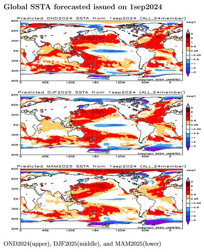
“The IRI plume predicts a weak and a short duration La Niña, as indicated by the Niño-3.4 index values less than -0.5°C (Fig. 6).  This month, the team relies more on the latest North American Multi-Model Ensemble (NMME) guidance, which predicts La Niña to emerge in the next couple of months and continue through the Northern Hemisphere winter.  The continuation of negative subsurface temperatures and enhanced low-level easterly wind anomalies supports the formation of a weak La Niña.  A weaker La Niña implies that it would be less likely to result in conventional winter impacts, though predictable signals could still influence the forecast guidance (e.g., CPC’s seasonal outlooks).  In summary, La Niña is favored to emerge in September-November (71% chance) and is expected to persist through January-March 2025 (Fig. 7).”

Below is the middle paragraph from the discussion last month.

“The IRI plume indicates that Niño-3.4 is most likely to be below La Niña thresholds for four overlapping seasons, from September-November 2024 through December 2024 – February 2025.  Based on updated guidance and recent observations, the forecast team predicts nearly equal chances for ENSO-neutral and La Niña in August-October 2024, with higher odds for La Niña in September-November. Although the rate of SST cooling has been slower than previously anticipated, below-average subsurface temperatures and low-level easterly wind anomalies remain conducive to La Niña development in the coming months.  In summary, ENSO-neutral is expected to continue for the next several months, with La Niña favored to emerge during September-November (66% chance) and persist through the Northern Hemisphere winter 2024-25 (74% chance during November-January). “

We now provide additional details.

CPC Probability Distribution

Here are the new forecast probabilities. The probabilities are for three-month periods e.g. ASO  stands for August/September/October.

Here is the forecast from last month.

The analysis this month and last month are a bit different with again the transition to La Nina being slightly slower than thought last month. This seems to be a trend. The chart is clearer than the discussion in the summary report above.  The La Nina is aa bit slower to arrive. I am not sure that we will actually have a La Nina.

Some will need to click on “Read More” to read the rest of this article.

Today Through the Fourth Friday (22 to 28 days) Weather Outlook for the U.S. and a Six-Day Forecast for the World: posted September 14, 2024

This article focuses on what we are paying attention to in the next 48 to 72 hours. The article also includes weather maps for longer-term U.S. outlooks and a six-day World weather outlook which can be very useful for travelers.

First the NWS Short Range Forecast. The afternoon NWS text update can be found here after about 4 p.m. New York time but it is unlikely to have changed very much from the morning update. The images in this article automatically update.

Short Range Forecast Discussion
NWS Weather Prediction Center College Park MD
Sat Sep 14 2024
Valid 12Z Sat Sep 14 2024 – 12Z Mon Sep 16 2024

…Heavy rain and flash flood threat will continue for portions of the
Southeast this weekend, then the flash flood threat will shift to the
Carolinas/Mid-Atlantic early next week…

…A strong low pressure system will bring unsettled weather to the West
late this weekend/early next week, with wintry precipitation expected at
high elevations…

…Well above average temperatures for the Central U.S. and Northeast;
well below average temperatures for the West…

Though it is now post-tropical, Francine will continue to bring a threat
for heavy rain and flash flooding to portions of the Southeast through
Sunday. The central area of low pressure will gradually sink south towards
the Gulf Coast with a stationary boundary extending to the Southeast Coast
and a cold front extending back towards the Southern Plains. The
stationary boundary will be the main focus for convection this weekend,
and training showers and thunderstorms with locally heavy rainfall will
create a threat for scattered instances of flash flooding. There is a
Slight Risk of Excessive Rainfall (level 2/4) for portions of Arkansas,
Tennessee, Mississippi, Alabama, and Georgia today and Sunday. Flash Flood
Watches are in effect for much of this area, and urban/poor drainage areas
and areas that already received heavy rainfall over the past few days will
be most at risk for flash flooding.

A separate area of low pressure will strengthen along the stationary
boundary extending from the Southeast Coast, which will maintain shower
and thunderstorm chances from Florida to the Carolinas and southern
Mid-Atlantic through early next week. This low pressure system is forecast
to gradually track north along the East Coast early next week and will
bring a heavy rain and flash flood threat to portions of the Carolinas and
Mid-Atlantic. There is a Slight Risk of Excessive Rainfall (level 2/4) for
eastern North Carolina on Monday where scattered instances of flash
flooding will be possible.

In the West, an unsettled pattern is forecast to develop this weekend as a
strong upper low pushes a frontal system across the region. The system
will nudge into the Pacific Northwest today, then move across northern
California, the Great Basin, and the northern Rockies Sunday and Monday.
Widespread showers and thunderstorms will accompany this system, and there
is a broad Marginal Risk of Excessive Rainfall (level 1/4) in effect for
portions of the Northern Rockies and Great Basin on Monday. This system
will also usher in well below normal temperatures, which will allow for
wintry precipitation to fall at higher elevations. A Winter Weather
Advisory is already in effect for portions of the Sierra Nevada where up
to 4 inches of snow may fall Sunday night and Monday. Precipitation
chances will also increase across the Southwest/Four Corners region late
this weekend into early next week as tropical moisture streams north ahead
of Tropical Cyclone Ileana.

Temperatures this weekend will have a large range across the United States
with well above average temperatures in the Central U.S. and Northeast and
well below average temperatures under the strong upper low in the West.
High temperatures will be in the 80s and 90s for the Central U.S. and
Northeast through Monday, which is more than 15 degrees above average for
some areas in the Upper Midwest/Great Lakes. High temperatures in the West
will be near to slightly below average today, then drop to 15 to 25
degrees below average in Oregon, California, and Nevada by Monday. Highs
in the 50s will be common in the Great Basin, and highs will likely only
reach the 30s and 40s in the Sierra Nevada.

To get your local forecast plus active alerts and warnings click HERE and enter your city, state or zip code.

Learn about wave patterns HERE.

Then, looking at the world and of course, the U.S. shows here also. Today we are looking at precipitation.

Please click on “Read More” below to access the full Daily Report issued today.

Today Through the Fourth Friday (22 to 28 days) Weather Outlook for the U.S. and a Six-Day Forecast for the World: posted September 13, 2024

This article focuses on what we are paying attention to in the next 48 to 72 hours. The article also includes weather maps for longer-term U.S. outlooks and a six-day World weather outlook which can be very useful for travelers.

First the NWS Short Range Forecast. The afternoon NWS text update can be found here after about 4 p.m. New York time but it is unlikely to have changed very much from the morning update. The images in this article automatically update.

Short Range Forecast Discussion
NWS Weather Prediction Center College Park MD
Fri Sep 13 2024
Valid 12Z Fri Sep 13 2024 – 12Z Sun Sep 15 2024

…Francine will continue to weaken while bringing a heavy rain and flash
flood threat to the Southeast over the next couple days…

…Above average temperatures will develop across the Central U.S. and
Northeast while below normal temperatures persist in the Southeast and
West…

Francine will continue to weaken today as its low pressure center meanders
east across northern Arkansas. A stationary boundary extending from the
occluded system will remain parked across the Southeast and provide a
focus for showers and thunderstorms through Saturday. The storm’s slow
motion will result in multiple days of heavy rain for the Southeast, which
will create a flash flooding risk. There is a Slight Risk of Excessive
Rainfall (level 2/4) today from western Tennessee through northern and
central Alabama to central/southern Georgia, with an embedded Moderate
Risk (level 3/4) for portions of northern and central Alabama. Flooding
will be most likely in urban and poor drainage areas and areas that
receive training/repeat convection, and locally considerable flash
flooding may be possible, especially where soils are already saturated
from previous rainfall. The flash flood threat will continue for these
areas on Saturday with another Slight Risk (level 2/4). Flood Watches are
in effect for much of the risk area. If you encounter flooding, turn
around, don’t drown. It is never safe to walk or drive into flood waters,
and most flood fatalities occur in vehicles. Isolated severe thunderstorms
will also be possible for parts of the Southeast today where the Storm
Prediction Center has issues a Marginal Risk of Severe Thunderstorms
(level 1/5). Severe storm hazards may include a few tornadoes or severe
wind gusts.

The flash flood and severe weather threats associated with Francine will
gradually decease through the weekend, and the remnants will begin moving
south Saturday night and stall along the Gulf Coast on Sunday. Another
area of low pressure is forecast to form along the stalled frontal
boundary off the Southeast Coast, which will create stormy weather from
Florida through the eastern Carolinas through this weekend into early next
week.

In the north, an occluded low pressure system north of Montana will push
further into Canada today and Saturday and will bring a weak cold front
across the northern and central Plains. Precipitation will linger on the
backside of the low in the northern Rockies and northern High Plains this
morning, and cold air will allow for snow and mixed wintry precipitation
at higher elevations. Shower and thunderstorm chances will accompany the
weak cold front through Saturday. Strong high pressure over the Northeast
will prevent the front from making significant eastward progress, and the
front will weaken and dissipate on Sunday.

In the West, a stronger Pacific frontal system will approach the coast
later today and move inland over the weekend. Precipitation chances will
begin in the Northwest late tonight/early Saturday and spread across the
Great Basin and northern California Sunday into Monday. Precipitation
chances will also increase across portions of the Southwest on Sunday as
tropical moisture from Ileana spreads north.

Temperatures will be on the rise this weekend across the Central U.S. and
Northeast, with high temperatures forecast to reach values as high as
10-15 degrees above normal for this time of year. Highs in the 80s and 90s
will be common for the Plains, Upper Midwest/Great Lakes, and Northeast.
Precipitation and cloud cover from Francine will keep temperatures below
average for much of the Southeast. Temperatures across much of the West
will be near to slightly below average through Saturday. On Sunday, the
Pacific frontal system will usher in cooler, unsettled weather, and
temperatures will drop to well below normal along the West Coast.

To get your local forecast plus active alerts and warnings click HERE and enter your city, state or zip code.

Learn about wave patterns HERE.

Then, looking at the world and of course, the U.S. shows here also. Today we are looking at precipitation.

Please click on “Read More” below to access the full Daily Report issued today.

Today Through the Fourth Friday (22 to 28 days) Weather Outlook for the U.S. and a Six-Day Forecast for the World: posted September 12, 2024

This article focuses on what we are paying attention to in the next 48 to 72 hours. The article also includes weather maps for longer-term U.S. outlooks and a six-day World weather outlook which can be very useful for travelers.

First the NWS Short Range Forecast. The afternoon NWS text update can be found here after about 4 p.m. New York time but it is unlikely to have changed very much from the morning update. The images in this article automatically update.

Short Range Forecast Discussion
NWS Weather Prediction Center College Park MD
Thu Sep 12 2024
Valid 12Z Thu Sep 12 2024 – 12Z Sat Sep 14 2024

…Heavy rainfall from Francine will spread into the Mid-South, Tennessee
Valley, and Southeast today while the severe weather threat shifts east
into Alabama and the Florida Panhandle…

…A round of moderate to heavy rain and strong thunderstorms with move
across the northern High Plains with high-elevation snow in the northern
Rockies…

…Elevated to critical fire weather concerns extend across much of the
High Plains and into portions of the central Great Basin…

Tropical Storm Francine continues to weaken and lift north early this
morning into southern Mississippi at the same time spreading gusty winds
and heavy rain across the region. The system is forecast to lose remaining
tropical characteristics later today as it pushes northward into the
Mid-South and connects with nearby frontal boundaries, while still
producing areas of locally heavy rain and chances for severe
thunderstorms. Tornadoes will be the main severe weather hazard through
tonight, potentially impacting parts of Alabama and the Florida Panhandle
along a slow-moving warm front. The Storm Prediction Center has issued a
Slight Risk (level 2/5) of severe weather for this region. The greatest
threat for considerable flash flooding exists across parts of northern and
central Alabama, where a slow-moving line of showers and thunderstorms
capable of containing intense rainfall rates could linger for several
hours and produce localized totals up to 10 inches. Heavy rain is also
possible from northeast Arkansas through the Tennessee Valley and into the
Florida Panhandle today. Looking ahead to the start of the weekend,
showers and localized torrential downpours will remain possible throughout
much of the Southeast as lingering tropical moisture and stationary
frontal boundaries stay draped across the region. Residents are advised to
have multiple ways of receiving warnings and never drive across flooded
roadways.

A potent storm system is also impacting parts of the West and High Plains
as an area of low pressure organizes in eastern Montana today. Areas of
heavy rain and severe weather are possible across the state. Gusty winds
and large hail associated with thunderstorms are most likely to impact
eastern Montana and far western North Dakota through tonight, with heavy
rain a potential weather hazard in central/western Montana. Additionally,
cool temperatures in the high elevations of the northern Rockies could
lead to early-season mountain snowfall for western Montana and the greater
Yellowstone National Park area. The other aspect of this system will
correspond with strong southerly winds throughout the High Plains. Wind
gusts up to 50 mph are possible, which could result in a few power
outages. These strong winds will also increase the fire weather threat
across the region as dry vegetation and low relative humidity create a
ripe environment for erratic fire behavior. Red Flag Warnings and/or Wind
Advisories span from southern Utah to North Dakota.

Elsewhere, high pressure will keep much of the Great Lakes and Northeast
dry as high temperatures increased into the 80s through the beginning of
this weekend. Warm and dry weather will also be found throughout the
Desert Southwest and southern Plains, with high temperatures into the
mid-to-upper 90s. Conversely, below average temperatures in the wake of a
cold front will be felt across much of the West to end the week.

cone graphic

To get your local forecast plus active alerts and warnings click HERE and enter your city, state or zip code.

Learn about wave patterns HERE.

Then, looking at the world and of course, the U.S. shows here also. Today we are looking at precipitation.

Please click on “Read More” below to access the full Daily Report issued today.

Today Through the Fourth Friday (22 to 28 days) Weather Outlook for the U.S. and a Six-Day Forecast for the World: posted September 11, 2024

This article focuses on what we are paying attention to in the next 48 to 72 hours. The article also includes weather maps for longer-term U.S. outlooks and a six-day World weather outlook which can be very useful for travelers.

First the NWS Short Range Forecast. The afternoon NWS text update can be found here after about 4 p.m. New York time but it is unlikely to have changed very much from the morning update. The images in this article automatically update.

Short Range Forecast Discussion
NWS Weather Prediction Center College Park MD
Wed Sep 11 2024
Valid 12Z Wed Sep 11 2024 – 12Z Fri Sep 13 2024

…Hurricane Francine is forecast to make landfall in Louisiana later this
evening with damaging winds, life-threatening storm surge, and torrential
rainfall…

…A round of moderate to heavy rain with high-elevation snow forecast
throughout the northern Rockies…

…Elevated to critical fire weather concerns across much of the Great
Basin and portions of the High Plains…

Ample attention is on the central Gulf Coast today as Hurricane Francine
is anticipated to make landfall in Louisiana this evening before spreading
impacts north to the Mid-South through the end of the week. Once the storm
pushes onshore south-central Louisiana tonight, life-threatening weather
conditions are expected to impact parts of the state, including the cites
of Lafayette, Baton Rouge, and New Orleans. Hazardous weather conditions
include storm surge, strong winds, torrential rainfall, and a few
tornadoes. While the strongest winds and peak storm surge are expected to
occur closer to the center of Francine in south-central portions of
Louisiana, the heavy rain and tornado threats are forecast to span much
farther east along the central and eastern Gulf Coast, including southern
Mississippi, Alabama, and the Florida Panhandle. In total, Francine is
expected to produce rainfall amounts of 4 to 8 inches, with local amounts
to 12 inches for the central/eastern Gulf Coast through Thursday night.
This rainfall could lead to considerable flash and urban flooding. As
Francine pushes northward into the Mid-South and weakens by the end of the
week, additional heavy rain is possible and could lead to scattered
instances of flash flooding. Additionally, a lingering frontal boundary
draped across the Florida Peninsula could lead to localized flash flooding
concerns over the next few days. Residents under hurricane-related
warnings should follow advice of local officials, including evacuation
orders, and never drive across flooded roadways.

A separate weather system will also impact the Nation through the end of
this week, with moderate to heavy rain and gusty winds impacting parts of
the Intermountain West and northern Rockies. This autumn storm will be
driven by a deep upper low crossing from the Northwest today before
closing-off and churning over the northern Rockies on Thursday. Most of
the impactful precipitation will be confined to the northern Rockies and
the High Plains on Montana. A few inches of rainfall could produce
flooding concerns throughout northwest Montana, prompting a Slight Risk
(level 2/4) of Excessive Rainfall both today and Thursday. Snow levels
dropping to around 7,000-8000 feet may also create hazardous winter-like
conditions for the high elevations of Montana Idaho, and northwest
Wyoming. The other aspect of this system will be associated with gusty
winds and increased fire weather concerns throughout the Great Basin and
High Plains. Strong winds combined with dry vegetation and low relative
humidity are forecast to be more pronounced over the Great Basin today and
increase the chances for erratic fire behavior. Additionally, elevated to
critical fire weather also exists across the High Plains and is most
apparent on Thursday as southerly winds increase in speed. Red Flag
Warnings and Fire Weather Watches have been issued throughout 10 states
between California and Nebraska. Outdoor burning is not recommended
throughout these regions and residents are reminded to not go near any
wildfires as they can spread quickly.

Otherwise, a large high pressure system over the Northeast will aid in
producing tranquil weather from the Great Lakes to much of the East. Well
above average temperatures are expected to overspread the north-central
U.S. before a warming trend is also noticeable across the southern Plains
by Friday. Highs across the northern Plains, Upper Midwest, and Great
Lakes are forecast to reach into the upper 80s and low 90s, while upper
90s eventually return to the western half of Texas and eastern New Mexico.

cone graphic

To get your local forecast plus active alerts and warnings click HERE and enter your city, state or zip code.

Learn about wave patterns HERE.

Then, looking at the world and of course, the U.S. shows here also. Today we are looking at precipitation.

Please click on “Read More” below to access the full Daily Report issued today.

Today Through the Fourth Friday (22 to 28 days) Weather Outlook for the U.S. and a Six-Day Forecast for the World: posted September 10, 2024

This article focuses on what we are paying attention to in the next 48 to 72 hours. The article also includes weather maps for longer-term U.S. outlooks and a six-day World weather outlook which can be very useful for travelers.

First the NWS Short Range Forecast. The afternoon NWS text update can be found here after about 4 p.m. New York time but it is unlikely to have changed very much from the morning update. The images in this article automatically update.

Short Range Forecast Discussion
NWS Weather Prediction Center College Park MD
Tue Sep 10 2024
Valid 12Z Tue Sep 10 2024 – 12Z Thu Sep 12 2024

…Life-threatening storm surge and hurricane-force winds, as well as the
risk of considerable flash flooding are forecast across southern Louisiana
on Wednesday as Francine approaches…

…Heavy rain expected to impact parts of the northern Rockies by
midweek…

…Elevated to critical fire weather concerns across much of the
Intermountain West…

As of early this morning Tropical Storm Francine continues churning in the
western Gulf of Mexico just to the southeast of Brownsville, Texas and
moving on a gradual northward motion. Francine is forecast to strengthen
into a hurricane before an expected landfall in southern Louisiana on
Wednesday. As the system approaches the central Gulf Coast and eventually
pushes inland across Louisiana, an increased threat of life-threatening
storm surge, hurricane-fore winds, and considerable flash flooding is
anticipated. Rainfall amounts of 4 to 8 inches, with local amounts up to
12 inches are forecast across much of central/eastern Louisiana and
Mississippi through Thursday night. Francine is then forecast to continue
its trek northward into the Mid-South on Thursday, while quickly
weakening. However, additional heavy rainfall and flash flooding concerns
are possible into western Tennessee neighboring regions. A stationary
front extending eastward from the center of the storm over the next few
days will also focus areas of numerous, slow-moving thunderstorms capable
of containing intense rainfall rates between the Florida Peninsula and
central Gulf Coast. Residents are reminded to remain weather-ready and
never drive across flooded roadways.

The only other section of the Lower 48 expecting chances for heavy rain
through midweek are parts the northern Rockies as a deep upper-level low
crosses over the region. A few inches of rainfall throughout northwest
Montana could lead to an increased risk of flash flooding on Wednesday,
which has prompted a Slight Risk (level 2/4) of Excessive Rainfall. This
storm system will also produce gusty winds throughout the Intermountain
West and lead to fire weather concerns. Specifically, the Storm Prediction
Center has issued a Critical Fire Weather area for much of Nevada and
western Utah. Current and continued wildfire activity over the Great Basin
will further add to the smokey skies noticeable throughout the northern
Plains, Midwest, and parts of the Ohio/Tennessee valleys.

High temperatures will remain above average average and into potentially
dangerous levels across parts of southern California and the Southwest
today before a quick cooldown commences by midweek. Meanwhile, upper
ridging in the north-central U.S. is expected to produce more summer-like
afternoon temperatures into the upper 80s and low 90s as far north as the
northern Plains and Upper Midwest by Thursday. These temperatures equate
to around 10 to 20 degrees above average, but are not expected to break
many daily records.

cone graphic

To get your local forecast plus active alerts and warnings click HERE and enter your city, state or zip code.

Learn about wave patterns HERE.

Then, looking at the world and of course, the U.S. shows here also. Today we are looking at precipitation.

Please click on “Read More” below to access the full Daily Report issued today.

Today Through the Fourth Friday (22 to 28 days) Weather Outlook for the U.S. and a Six-Day Forecast for the World: posted September 9, 2024

This article focuses on what we are paying attention to in the next 48 to 72 hours. The article also includes weather maps for longer-term U.S. outlooks and a six-day World weather outlook which can be very useful for travelers.

First the NWS Short Range Forecast. The afternoon NWS text update can be found here after about 4 p.m. New York time but it is unlikely to have changed very much from the morning update. The images in this article automatically update.

Short Range Forecast Discussion
NWS Weather Prediction Center College Park MD
Mon Sep 09 2024
Valid 12Z Mon Sep 09 2024 – 12Z Wed Sep 11 2024

…Heavy rain and a risk of flash flooding expected throughout much of the
Gulf Coast and Florida Peninsula into midweek…

…Potentially dangerous heat forecast across southern California and the
Southwest today…

…Elevated to critical fire weather concerns as well as Air Quality
Alerts remain across much of the Great Basin…

A stationary front extending from the Florida Peninsula through the
northern Gulf of Mexico along with a gradually organizing area of low
pressure in the southwest Gulf of Mexico (labeled Potential Tropical
Cyclone Six by the National Hurricane Center) will continue to produce
areas of heavy rain and the risk of flash flooding through midweek. For
today, the heaviest rainfall is anticipated over portions of southern
Texas, the central Gulf Coast, and much of the Florida Peninsula, mainly
associated with scattered showers and thunderstorms near the stationary
boundary. This may lead to isolated flash flooding concerns mainly
concentrated to urban locations. By Tuesday and more pronounced on
Wednesday, increased moisture content and organized bands of thunderstorms
associated with Potential Tropical Cyclone Six are forecast to reach the
western and central Gulf Coast. This will increase the risk of heavy
rainfall and considerable flash flooding. At the moment, the greatest risk
for rainfall amounts up to 12 inches and numerous flash floods are
forecast throughout southern Louisiana. Life-threatening storm surge and
damaging winds are also possible from the Upper Texas Coast to the
Louisiana coastline as the system is forecast to reach hurricane strength
in the northwest Gulf of Mexico by midweek. Residents should ensure they
have their hurricane plan in place and check www.nhc.noaa.gov for the
latest forecast.

Dangerous heat is in the forecast for at least one additional day for
southern California and parts of the Southwest. Highs into the upper 90s
and triple digits have prompted Excessive Heat Warnings and Heat
Advisories to be issued, with a cooling trend set to commence by midweek.
The combination of above average temperatures, dry vegetation, and gusty
winds have resulted in elevated to critical fire weather concerns
throughout much of the Intermountain West through the next couple of days.
Additionally, current wildfires continue to pump smoke into the atmosphere
of the northern Great Basin, leading to poor air quality. This smoke is
also forecast to extend eastward in the mid-to-upper levels of the
atmosphere through the northern Plains and Ohio Valley, creating
noticeably hazy skies.

Elsewhere, well above average temperatures are expected across the
north-central U.S. as highs return to the upper 80s and low 90s, which
equates to around 10-15 degrees above average. Cooler, fall-like
temperatures will kickoff the new workweek throughout the Ohio Valley and
East until temperatures return to near normal by Wednesday as the dominant
high pressure system in place slowly slides eastward to the western
Atlantic.

While notable precipiation should be mostly sparse across the Lower 48
outside of the Gulf Coast, a few areas of locally heavy rain are possible
across the Northeast and Northwest through Wednesday. Isolated severe
thunderstorms are possible throughout Upstate New York today as a weak
cold front dives across the region, with some storms potentially
containing damaging wind gusts. Increasing precipitation chances are also
forecast to spread into the Northwest and Northern Rockies as a deep upper
low swings eastward from the northeast Pacific.

cone graphic

To get your local forecast plus active alerts and warnings click HERE and enter your city, state or zip code.

Learn about wave patterns HERE.

Then, looking at the world and of course, the U.S. shows here also. Today we are looking at precipitation.

Please click on “Read More” below to access the full Daily Report issued today.

Today Through the Fourth Friday (22 to 28 days) Weather Outlook for the U.S. and a Six-Day Forecast for the World: posted September 8, 2024

This article focuses on what we are paying attention to in the next 48 to 72 hours. The article also includes weather maps for longer-term U.S. outlooks and a six-day World weather outlook which can be very useful for travelers.

First the NWS Short Range Forecast. The afternoon NWS text update can be found here after about 4 p.m. New York time but it is unlikely to have changed very much from the morning update. The images in this article automatically update.

Short Range Forecast Discussion
NWS Weather Prediction Center College Park MD
Sun Sep 08 2024
Valid 12Z Sun Sep 08 2024 – 12Z Tue Sep 10 2024

…Dangerous heat continues to impact portions of southern California and
the Southwest through Monday…

…Heavy rain and scattered instances of flash flooding remain possible
along the Gulf Coast and parts of the Southeast over the next several
days…

…Below average temperatures forecast across much of the Midwest and East
through the beginning of the week…

Potentially dangerous and record-breaking heat is forecast to continue
across southern California as highs soar into the upper 90s and triple
digits away from the immediate coastline. Excessive Heat Warnings remain
in effect through Monday as a gradual cooldown commences on Tuesday. Highs
into the triple digits are also forecast throughout the remainder of the
Desert Southwest, but not considered as anomalous as values forecast
across southern California. Elsewhere, above average temperatures are
anticipated across the northern Great Basin and northern Plains as
upper-level ridging slides eastward. Heat will wane across eastern
Washington and neighboring states by Tuesday as the core of the
late-summer temperatures concentrate over the northern Plains. Highs in
the north-central U.S. are forecast to reach into the low-to-mid 90s early
this week, which equates to around 10 to 20 degrees above average for this
time of year. Additionally, sultry heat and humidity will impact southern
Florida once again today, where Heat Advisories have been issued due to
maximum heat indices forecast to near 110 degrees. Remember to follow
proper heat safety by staying hydrated, limiting strenuous outdoor
activity during peak daytime heating, and checking on vulnerable
individuals.

Much of the Nation is anticipated to be void of notable precipitation over
the next few days, with the Gulf Coast and parts of the Southeast being
the lone exception. A lingering stationary front and developing area of
low pressure in the western Gulf of Mexico will focus heavy rainfall
potential from the coastal Carolinas to the Florida Peninsula and entire
Gulf Coast region. Scattered flash flooding is possible where the heaviest
rainfall occurs, with urban and low-lying areas most at risk to flooding
impacts. Otherwise, isolated flash flooding is also possible in parts of
the Intermountain West through early this week due to widely scattered
thunderstorms developing in tandem with daytime heating.

Large surface high pressure extending from the southern Plains to the
Midwest and East throughout Tuesday will not only supply sunny and dry
conditions for much of the Lower 48, but well below average temperatures
as well. In fact, daily record lows are possible between the Midwest and
Mid-Atlantic this morning as temperatures dip into the 40s for most
locations. Patchy frost is possible in low lying protected areas. As this
autumnal airmass moderates somewhat early this week, afternoon
temperatures will gradually warm back into the mid-80s by Tuesday.

To get your local forecast plus active alerts and warnings click HERE and enter your city, state or zip code.

Learn about wave patterns HERE.

Then, looking at the world and of course, the U.S. shows here also. Today we are looking at precipitation.

Please click on “Read More” below to access the full Daily Report issued today.

Today Through the Fourth Friday (22 to 28 days) Weather Outlook for the U.S. and a Six-Day Forecast for the World: posted September 7, 2024

This article focuses on what we are paying attention to in the next 48 to 72 hours. The article also includes weather maps for longer-term U.S. outlooks and a six-day World weather outlook which can be very useful for travelers.

First the NWS Short Range Forecast. The afternoon NWS text update can be found here after about 4 p.m. New York time but it is unlikely to have changed very much from the morning update. The images in this article automatically update.

Short Range Forecast Discussion
NWS Weather Prediction Center College Park MD
Sat Sep 07 2024
Valid 12Z Sat Sep 07 2024 – 12Z Mon Sep 09 2024

…Dangerous heat continues to impact portions of the West this weekend…

…Heavy rain and scattered instances of flash flooding are possible along
the Gulf Coast and parts of the Southeast…

…Below average temperatures to settle in across much of the Midwest and
East through the beginning of next week…

A few more days of record-breaking and dangerous heat are in store for
parts of the West as well above average temperatures linger underneath a
weakening upper-level high pressure system. Areas most likely to
experience major to extreme HeatRisk (levels of heat that affect anyone
without effective cooling or adequate hydration) through Sunday include
southern California, the Desert Southwest, and the northern Great Basin.
These regions are also where Excessive Heat Warnings and Heat Advisories
remain in effect. High temperatures in the Southwest are expected to soar
into the upper 90s and triple digits, with 110s in the typically hottest
desert locations through at least Monday. Highs into the upper 90s are
forecast to simmer the northern Great Basin before a gradual cooling trend
commences by early next week, with the anomalously warm temperatures
forecast to shift eastward into the northern Plains. Residents and
visitors are advised to continue following proper heat safety. This
includes staying hydrated and avoiding extended periods of time outdoors
during the hottest parts of the day. Poor air quality will also remain a
concern for parts of the Great Basin as wildfire smoke continues to
overspread the region.

A stationary front extending from off the Southeast coastline to the
northern Gulf of Mexico will continue to provide a focus for numerous
showers and thunderstorms over the next few days as its moisture gradient
gets reinforced by a separate approaching cold front sinking southward
across the Deep South today. Areas of locally heavy rain and scattered
flash floods are possible from the coastal Carolinas to the central Gulf
Coast, including northern and central Florida. Greater concentration of
tropical downpours are anticipated to reorient to southern Texas by Monday
as an area of low pressure develops in the Bay of Campeche and ushers
elevated atmospheric moisture westward to the western Gulf Coast.

Elsewhere, a cold front sweeping across the East Coast today will produce
scattered showers and thunderstorms throughout the Northeast. Behind this
frontal boundary and underneath potent high pressure, below average and
crisp temperatures are expected to overspread much of the Great Lakes,
Midwest, and East this weekend. Widespread lows into the 40s will lead to
a few chilly mornings, with several daily record lows possible between
Missouri and New Jersey on Sunday. Patchy frost cannot be ruled out for
some locations. Conversely, southern Florida will remain hot and humid
this weekend as high temperatures rise into the low-to-mid 90s, while heat
indices approach 110 degrees.

To get your local forecast plus active alerts and warnings click HERE and enter your city, state or zip code.

Learn about wave patterns HERE.

Then, looking at the world and of course, the U.S. shows here also. Today we are looking at precipitation.

Please click on “Read More” below to access the full Daily Report issued today.

Today Through the Fourth Friday (22 to 28 days) Weather Outlook for the U.S. and a Six-Day Forecast for the World: posted September 6, 2024

This article focuses on what we are paying attention to in the next 48 to 72 hours. The article also includes weather maps for longer-term U.S. outlooks and a six-day World weather outlook which can be very useful for travelers.

First the NWS Short Range Forecast. The afternoon NWS text update can be found here after about 4 p.m. New York time but it is unlikely to have changed very much from the morning update. The images in this article automatically update.

Short Range Forecast Discussion
NWS Weather Prediction Center College Park MD
Fri Sep 06 2024
Valid 12Z Fri Sep 06 2024 – 12Z Sun Sep 08 2024

…Dangerous heat continues to impact large sections of the West into this
weekend…

…Heavy rain and instances of flash flooding are likely throughout the
central Gulf Coast and Southeast over the next few days…

…Showers and isolated severe thunderstorms possible from the Ohio Valley
to the Lower Great Lakes today…

An upper level high pressure system is expected to continue aiding well
above average and potentially dangerous temperatures throughout the West
into the first full weekend of September. Highs today are forecast to soar
into the triple digits for much of the Southwest and interior California,
with 110s in the typically hottest locations of the Desert Southwest.
Meanwhile, daily high temperature records are possible in the Northwest
where mid-to-upper 90s are in the forecast. A minimal relaxing of the
extreme heat should be felt throughout much of the West and Southwest on
Saturday, but with temperatures remaining above average. The core of the
anomalous heat will shift to the northern Great Basin and northern Rockies
as parts of eastern Oregon and Washington experience another day with
highs well into the 90s. Poor air quality will also remain an issue
throughout parts of the northern Great Basin as wildfire smoke continues
to plague the region. Residents and visors are advised to follow proper
heat safety, which includes checking on vulnerable individuals.

Not much heavy precipitation to speak of throughout the Nation over the
next few days besides along the Gulf Coast and parts of the Southeast. A
lingering stationary front and a couple waves of low pressure will provide
a focus for tropical downpours over already saturated soils. The greatest
threat for heavy rainfall turning into flash flooding impacts are forecast
across southeast Louisiana today, where a Moderate Risk (level 3/4) of
Excessive Rainfall has been issued. Several inches of rain occurring
within a very short period of time could lead to numerous flash floods
here. A scattered flash flood threat also extends eastward along and just
north of the stationary front into northern Florida and southern Georgia.
This frontal boundary is expected to gradually sink southward by Saturday
as an area of low pressure exits off the Southeast coastline, with a
persisting isolated flash flood potential extending from the central Gulf
Coast and northern Florida to the coastal Carolinas. Remember, most flood
fatalities occur within vehicles… turn around, don’t drown.

Elsewhere, a cold front sweeping across the Ohio Valley and Lower Great
Lakes will usher in below average temperatures throughout the Great Lakes,
Midwest, before reaching the East Coast by this weekend, while also
producing areas of showers and thunderstorms. A few storms could produce
locally gusty winds and hail today in the Ohio Valley and nearby Lake Erie
region. Scattered showers are expected to progress eastward along the cold
front on Saturday and dampen weekend plans throughout the Interior
Northeast and sections of New England by Saturday evening.

To get your local forecast plus active alerts and warnings click HERE and enter your city, state or zip code.

Learn about wave patterns HERE.

Then, looking at the world and of course, the U.S. shows here also. Today we are looking at precipitation.

Please click on “Read More” below to access the full Daily Report issued today.