Weather Outlook for the U.S. for Today Through at Least 22 Days and a Six-Day Forecast for the World: posted September 22, 2024

This article focuses on what we are paying attention to in the next 48 to 72 hours. The article also includes weather maps for longer-term U.S. outlooks (up to four weeks) and a six-day World weather outlook which can be very useful for travelers.

First the NWS Short Range Forecast. The afternoon NWS text update can be found here after about 4 p.m. New York time but it is unlikely to have changed very much from the morning update. The images in this article automatically update.

Short Range Forecast Discussion
NWS Weather Prediction Center College Park MD
Sun Sep 22 2024
Valid 12Z Sun Sep 22 2024 – 12Z Tue Sep 24 2024

…A low pressure wave will bring showers and possible severe weather
across the central High Plains this morning…

…Rounds of heavy rain and embedded thunderstorms are expected to stretch
from the south-central Plains through the mid-Mississippi Valley, Midwest,
and into the Ohio Valley for the next couple of days…

…Locally heavy rain and strong thunderstorms moving across the interior
Mid-Atlantic this morning…

Much of the active weather for the next couple of days will continue to be
focused in the vicinity of a slow-moving frontal boundary stretching from
the south-central Plains through the mid-Mississippi Valley, Midwest, and
into the Ohio Valley. The strongest thunderstorms are expected to
traverse the Texas and Oklahoma Panhandles early this morning, and then
weaken during the day as they move farther east. Rounds of heavy rain and
embedded thunderstorms can also be found this morning across the central
Plains into the Midwest, followed by addition showers and thunderstorms
forming and moving across Lower Michigan during the day today.

By Monday, a low pressure wave is forecast to organize along the front and
move northeast across the south-central Plains. Showers and embedded
thunderstorms can be expected to accompany the low as well as the frontal
boundary. By Tuesday morning, showers and embedded strong thunderstorms
are expected to move across the Midwest toward the Ohio Valley as the low
pressure center tracks across the region.

Across the interior Mid-Atlantic, a subtle upper-level disturbance is
delivering a round of heavy rain with strong to locally severe
thunderstorms moving from north to south this morning. Meanwhile, recent
wet weather in the vicinity of Cape Cod is lingering into this morning.
As the slow-moving coastal cyclone begins to slide further out into the
Atlantic, the rain is forecast to end during the day today.

The high-elevation of central Colorado is waking up to some wet snow due
to an influx of colder air associated with the upper low. The upper low
will lift into the southern Plains, allowing much of the western U.S. to
remain dry for the next couple of days with near normal temperatures.
Colder air will surge down the Plains behind the front but 90s will be
common in the afternoon across the South into the interior eastern U.S.
ahead of the front.

To get your local forecast plus active alerts and warnings click HERE and enter your city, state or zip code.


Learn about wave patterns HERE.

Then, looking at the world and of course, the U.S. shows here also. Today we are looking at precipitation.

Please click on “Read More” below to access the full Daily Report issued today.

Midwest Drought Update – Published on September 21, 2024

Before we get started on this,  I want to include the key graphic from the Updated Four Season  Outlook that we discussed  HERE  yesterday.

The top row is what is now called the Mid-Month Outlook for next month which will be updated at the end of this month. There is a temperature map and a precipitation map. The second row is a three-month outlook that includes next month.

Some will need to click on “Read More” to read the full article.

Weather Outlook for the U.S. for Today Through at Least 22 Days and a Six-Day Forecast for the World: posted September 21, 2024

This article focuses on what we are paying attention to in the next 48 to 72 hours. The article also includes weather maps for longer-term U.S. outlooks (up to four weeks) and a six-day World weather outlook which can be very useful for travelers.

First the NWS Short Range Forecast. The afternoon NWS text update can be found here after about 4 p.m. New York time but it is unlikely to have changed very much from the morning update. The images in this article automatically update.

Short Range Forecast Discussion
NWS Weather Prediction Center College Park MD
Sat Sep 21 2024
Valid 12Z Sat Sep 21 2024 – 12Z Mon Sep 23 2024

…Threat of heavy rainfall and severe weather will be focused across the
central U.S. and into Midwest for the next couple of days…

…A slow-moving coastal storm will bring another rainy day today across
southeastern New England and coastal flooding during high tides for the
northern Mid-Atlantic coast…

…Much below normal temperatures surge into the central High Plains on
Sunday as above average temperatures shift east from the Plains into the
Ohio and Mississippi Valley…

Most of the active weather for the next couple of days will be focused
across the central U.S. and will slowly shift east into the Midwest by
Monday morning. This is in response to a vigorous upper-level low
pressure system that will swing across the Southwest today and then
interact with a surge of cool air down from western Canada. Thunderstorms
are expected to develop quickly later today across the southern High
Plains where severe weather will be possible as a cold front surges south
and clashes with warm and moist air lifted northward by the upper low. By
Saturday night into Sunday, the main activities will then gradually shift
east across the central Plains toward the mid-Mississippi Valley as low
pressure waves form along the front. Sunday into Monday morning will see
the potential of heavy rain shifting farther east into the Midwest and
toward the Ohio Valley. Meanwhile, colder air behind the system will
change the rain into wet snow across the higher elevations of Colorado
Rockies Saturday night into Sunday morning. Showers and embedded
thunderstorms can also be expected farther north near/behind the cold
front across the northern Plains today, into the upper Midwest tonight,
followed by the upper Midwest and the Great Lakes Sunday into Monday
morning.

Temperatures will fall precipitously on the backside of the cold front
over portions of the southern High Plains and central Plains beginning
Saturday. High temperatures in the 50s will represent 15 to 30 degree
departures from average for the aforementioned areas. Above average
temperatures will be in place across the Midwest and Southeast this
weekend as upper-level ridging extending from Mexico into Texas remains in
place. Elsewhere, a slow-moving coastal storm will bring another rainy
day across southeastern New England with coastal flooding during high
tides for the northern Mid-Atlantic coast for today before the storm
slowly moves out into the Atlantic on Sunday.

To get your local forecast plus active alerts and warnings click HERE and enter your city, state or zip code.


Learn about wave patterns HERE.

Then, looking at the world and of course, the U.S. shows here also. Today we are looking at precipitation.

Please click on “Read More” below to access the full Daily Report issued today.

NOAA Updates its Seasonal Outlook on September 19, 2024 – Similar to the Outlook Issued last Month but the potential La Nina is Downgraded – Posted on September 20, 2024

On the third Thursday of the month right on schedule NOAA issued their updated Seasonal Outlook which I describe as their Four-Season Outlook because it extends a bit more than one year into the future. The information released also included the Mid-Month Outlook for the following month plus the weather and drought outlook for the next three months.  I present the information issued by NOAA and try to add context to it. It is quite a challenge for NOAA to address the subsequent month, the subsequent three-month period as well as the twelve successive three-month periods for a year or a bit more.

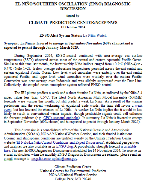
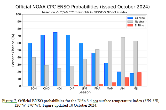
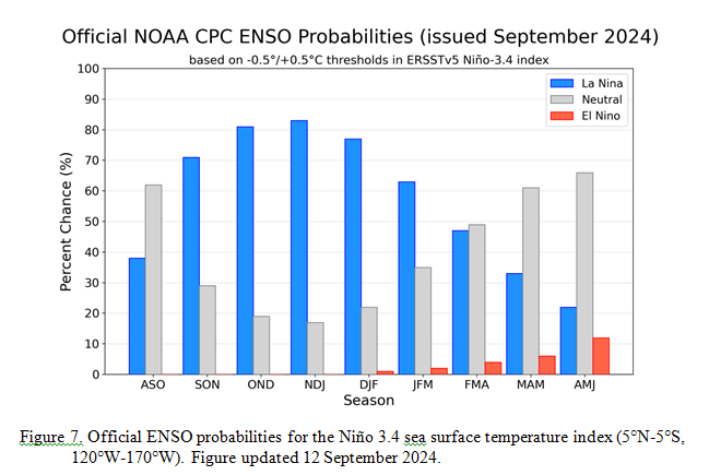
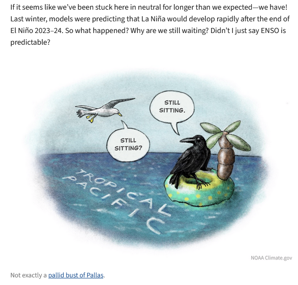
With respect to the long-term part of the Outlook which I call the Four-Season Outlook, the timing of the transition from Neutral to LaNina is challenging to predict.  We are now in ENSO Neutral. La Nina is the likely scenario soon, but the strength of the La Nina may be fairly  weak..

From the NOAA discussion:

“The most recent International Research Institute (IRI) for Climate and Society plume forecast of the Niño-3.4 SST index predicts a weak and a short duration La Niña, as indicated by the Niño-3.4 index values less than -0.5°C. This month, the latest North American Multi-Model Ensemble (NMME) guidance was relied upon, which predicts La Niña to emerge in the next couple of months and continue through the Northern Hemisphere winter. The continuation of negative subsurface temperatures and enhanced low-level easterly wind anomalies supports the formation of a weak La Nina. In summary, La Niña is favored to emerge in SON (71% chance) and is expected to persist through JFM 2025.”

“However, chances of a moderate to strong La Niña are currently less than 50% through the Fall and Winter. ENSO-neutral conditions are favored to re-emerge by the February-April (FMA) 2025 season.”

I personally would not have total confidence in this outlook given the uncertainty about there actually being a La Nina and its strength if it does happen.  I  do not have the JAMSTEC outlook yet but for sure they will lean towards a weak La Nina with Modoki characteristics. I do not have a lot of confidence that NOAA knows how to deal with a La Nina Modoki. But they may have it exactly correct.

Let’s Take a Look at the (mid-month) Outlook for October

It will be updated on the last day of August.

Then we look at a graphic that shows both the next month and the next three months.

The top row is what is now called the Mid-Month Outlook for next month which will be updated at the end of this month. There is a temperature map and a precipitation map. The second row is a three-month outlook that includes next month.  I think the outlook maps are self-explanatory. What is important to remember is that they show deviations from the current definition of normal which is the period 1991 through 2020.  So this is not a forecast of the absolute value of temperature or precipitation but the change from what is defined as normal or to use the technical term “climatology”.

Notice that the Outlook for next month and the three-month Outlook are dissimilar. This tells us that November and December will be substantially different than October.

The full NOAA Seasonal Outlook extends through October/November/December of 2025 (yes that is more than a year out). All of these maps are in the body of the article. Large maps are provided for October and the three-month period October/November/December  Small maps are provided beyond that through October/November/December of 2025 with a link to get larger versions of these maps.

NOAA provides a discussion to support the maps. It is included in the body of this article. In some cases, one will need to click on “read more” to read the full article. For those on my email list where I have sent the url of the article, that will not be necessary.

Weather Outlook for the U.S. for Today Through at Least 22 Days and a Six-Day Forecast for the World: posted September 20, 2024

This article focuses on what we are paying attention to in the next 48 to 72 hours. The article also includes weather maps for longer-term U.S. outlooks (up to four weeks) and a six-day World weather outlook which can be very useful for travelers.

First the NWS Short Range Forecast. The afternoon NWS text update can be found here after about 4 p.m. New York time but it is unlikely to have changed very much from the morning update. The images in this article automatically update.

Short Range Forecast Discussion
NWS Weather Prediction Center College Park MD
Fri Sep 20 2024
Valid 12Z Fri Sep 20 2024 – 12Z Sun Sep 22 2024

…Severe thunderstorm threat will shift from the upper Midwest this
morning to the southern High Plains by Saturday night/early Sunday…

…Rainy weather lingers over southeastern New England…

…A moderate to heavy rain event developing this weekend from the central
High Plains eastward toward the Mid-Mississippi Valley…

…Much above average temperatures through the mid-section of the country
and into Ohio Valley and Great Lakes…

A cold/occluded frontal system clashing with a weak warm front will
continue to support formation of strong to severe thunderstorms across the
upper Midwest early this morning. These thunderstorms will generally lose
intensity as they move into the Great Lakes through the rest of today.
The relatively fast motion of the front will limit rainfall amounts.
However, there is still the potential for isolated heavy totals, that
could result in localized flooding, especially over urbanized regions.

The deep low pressure system associated with the fronts are moving farther
away into central Canada. There will not be much temperature relief in
the wake of the fronts from the much above average temperatures currently
stretching across the Plains into the mid- to upper Mississippi Valley and
Great Lakes. These regions will continue to see some late summer heat
over the next two days. An Alberta clipper will take shape and will then
usher in a fresh dose of cool air from western Canada through the northern
Rockies followed by northern Plains this weekend.

There is not expected to be large areas of heavy rains across the lower 48
over the next two days. Exceptions will be across southeastern New
England where a slow-moving low off the southeast New England coast will
keep conditions wet Friday and Saturday. Showery weather will also likely
to persist across South Florida where tropical moisture will bring the
potential for localized heavy rains and isolated urban flash flooding from
daily thunderstorms.

A strong mid to upper level low moving onshore into the central to
southern California coast will be pressing eastward for the next couple of
days across the Southwest and into the Four Corners region. There is not
expected to be any large areas of precipiation associated with this strong
mid to upper level low across central to southern California into the
Southwest. However, during Saturday, higher levels of moisture are
expected to be transported northward ahead of the mid to upper level low
into the central to southern Rockies and southern High Plains as the
moisture begins to interact with a surge of cool air from the north. This
interaction will initiate an increasingly large precipitation event, first
across portions of the central to Southern Rockies on Saturday, then
expanding eastward Saturday evening/night into the central Plains and
lower Missouri Valley, and then toward the Mid-Mississippi Valley early on
Sunday. In addition, the potential of severe thunderstorms will increase
later on Saturday into early Sunday over the southern High Plains ahead of
a cold front and a dry line. In addition, cold air behind the front will
change the rain to wet snow over the Colorado Rockies early on Sunday.

To get your local forecast plus active alerts and warnings click HERE and enter your city, state or zip code.

Learn about wave patterns HERE.

Then, looking at the world and of course, the U.S. shows here also. Today we are looking at precipitation.

Please click on “Read More” below to access the full Daily Report issued today.

Weather Outlook for the U.S. for Today Through at Least 22 Days and a Six-Day Forecast for the World: posted September 19, 2024

This article focuses on what we are paying attention to in the next 48 to 72 hours. The article also includes weather maps for longer-term U.S. outlooks (up to four weeks) and a six-day World weather outlook which can be very useful for travelers.

First the NWS Short Range Forecast. The afternoon NWS text update can be found here after about 4 p.m. New York time but it is unlikely to have changed very much from the morning update. The images in this article automatically update.

Short Range Forecast Discussion
NWS Weather Prediction Center College Park MD
Thu Sep 19 2024
Valid 12Z Thu Sep 19 2024 – 12Z Sat Sep 21 2024

…Severe thunderstorms possible in the eastern Plains and Upper Midwest
today…

…Late-summer heat forecast from the southern/central Plains to the Upper
Midwest…

The main weather story for the next couple of days will be a strong
occluded low and frontal system bringing impactful weather to the Plains
and Midwest. The central low will gradually lift north into southern
Canada today while it pushes a strong cold front across the eastern Plains
and Upper Midwest. Precipitation will taper off in Montana and the
northern Plains by this afternoon as the low moves farther away, and the
focus for precipitation will shift to areas ahead of the cold front. A
line of showers and thunderstorms is forecast to develop ahead of the cold
front today, and a wave of upper level energy moving over the Upper
Midwest will provide support for scattered severe thunderstorm development
this afternoon into tonight. The Storm Prediction Center has highlighted
portions of the Upper Midwest and eastern portions of the central and
southern Plains with a Slight Risk of Severe Thunderstorms (level 2/4).
Potential storm hazards will include a couple of tornadoes, large hail,
and damaging wind gusts. Additionally, locally heavy rain in stronger
storms may result in isolated instances of flash flooding in the Upper
Midwest.

Showers and storms ahead of the cold front will push east into the Great
Lakes region on Friday, but the front will weaken as it becomes separated
from its parent low in Canada. Shower and storm chances will also linger
along the eastern seaboard as a low pressure system strengthens offshore
in the western Atlantic. The main low will remain parked southeast of Cape
Cod over the next few days while a slow-moving cold front extends
southwest to the Florida Peninsula. Strong gusty winds will be possible
over the coastal waters in the vicinity of the central low, which has
prompted the issuance of Small Craft and Coastal Flood Advisories along
portions of the Mid-Atlantic and Northeast Coasts and Gale Warnings for
the offshore waters south of Cape Cod and Long Island. This system will
finally pull away from the East Coast by Sunday, which will result in
decreasing winds and precipitation chances.

Calmer weather is expected for the West today, with some lingering showers
and storms under an upper low in the Great Basin and California, then the
next round of unsettled weather will arrive with a southward moving
frontal system Friday and Saturday. Precipitation will spread from the
Northwest and northern Rockies south to the Four Corners Region by
Saturday, and some wintry precipitation will be possible in the higher
elevations of the Intermountain West. Precipitation chances will also
expand again across the Plains and portions of the Midwest late Friday
into Saturday as the frontal system pushes east of the Rockies.

Temperature-wise, late-summer heat will stick around in the Central U.S.
through the end of this week. Warm southerly flow will keep high
temperatures in the 80s and 90s from the southern/central Plains to the
Upper Midwest. Some areas in the southern Plains could see near record
highs today and Friday as highs approach 100 degrees. Above average
temperatures are also forecast for the Great Lakes and interior Northeast
underneath an upper level ridge. Temperatures in the West will remain
below normal over the next few days in the wake of the Plains system and
the upcoming late week frontal system. Temperatures in the East and
Southeast will be near normal with highs generally in the 70s and 80s.

To get your local forecast plus active alerts and warnings click HERE and enter your city, state or zip code.

Learn about wave patterns HERE.

Then, looking at the world and of course, the U.S. shows here also. Today we are looking at precipitation.

Please click on “Read More” below to access the full Daily Report issued today.

Today Through the Fourth Friday (22 to 28 days) Weather Outlook for the U.S. and a Six-Day Forecast for the World: posted September 18, 2024

This article focuses on what we are paying attention to in the next 48 to 72 hours. The article also includes weather maps for longer-term U.S. outlooks and a six-day World weather outlook which can be very useful for travelers.

First the NWS Short Range Forecast. The afternoon NWS text update can be found here after about 4 p.m. New York time but it is unlikely to have changed very much from the morning update. The images in this article automatically update.

Short Range Forecast Discussion
NWS Weather Prediction Center College Park MD
Wed Sep 18 2024
Valid 12Z Wed Sep 18 2024 – 12Z Fri Sep 20 2024

…Very heavy rainfall and flash flooding possible in Montana today…

…Severe thunderstorms possible in the northern and central Plains and
Upper Midwest today and Thursday…

A strong occluded low will bring hazardous weather to Montana today as it
lingers over the state. Strong upslope flow along the northern Rockies on
the backside of the low will result in showers and thunderstorms with very
heavy rainfall totals. A Slight Risk of Excessive Rainfall (level 2/4) is
in effect for portions of Montana where scattered flash flooding will be
possible. Wintry precipitation will also be possible in the high
elevations of the northern Rockies. In addition to precipitation hazards,
a strong pressure gradient in the vicinity of the central low will result
in strong, gusty winds across the region. High Wind Watches and Warnings
are in effect for portions of Montana and Wyoming where winds are forecast
to be 30-40 mph with gusts up 60 mph. The low will gradually lift north
into southern Canada Thursday and Friday, and rain and winds will begin to
relax.

The strong low pressure system will also push a cold front across the
Plains and Upper Midwest through Friday. A line of showers and
thunderstorms will move east ahead of the cold front, and the environment
will support the development of scattered severe thunderstorms. The Storm
Prediction Center has highlighted portions of the Plains and Upper Midwest
with a Slight Risk of Severe Thunderstorms (level 2/5) today and again on
Thursday. Potential severe storm hazards will include damaging wind gusts,
large hail, and a few tornadoes. Shower and thunderstorm coverage will
expand into the Great Lakes and Mid-Mississippi and Ohio Valleys on Friday
as the cold front continues to trek east.

Elsewhere, two coastal lows will sandwich the continental United States,
one moving south along the West Coast and one moving north along the East
Coast. The West Coast low will bring precipitation to the Northwest this
morning, then to the Great Basin and California later today into Thursday.
Precipitation will fall mainly in the form of showers and thunderstorms,
but some wintry precipitation will be possible in the Sierra Nevada. The
low will weaken on Friday, and precipitation will taper off. The East
Coast low will gradually deepen offshore of the Mid-Atlantic over the next
few days with a slow-moving frontal boundary extending southwest from the
low. Showers and storms will be possible for the Mid-Atlantic, coastal
Northeast, Southeast, and Florida. This system will also produce gusty
winds over the coastal waters, which has prompted Small Craft and Coastal
Flood Advisories along the Mid-Atlantic Coast.

Temperature-wise, the West will experience well below average temperatures
in the wake of the strong frontal system in the Plains, while the Central
U.S. experiences well above average temperatures with southerly flow ahead
of the Plains system. Highs over the next few days will only be in the 60s
and 70s for much of the West, while highs in the Plains and Midwest reach
the 80s and 90s. A few near-record high temperatures will be possible in
the southern Plains where highs will approach 100 degrees. Above average
temperatures will also be observed in the Northeast under an upper level
ridge, and near to slightly below normal temperatures will be observed in
the Mid-Atlantic and Southeast.

To get your local forecast plus active alerts and warnings click HERE and enter your city, state or zip code.

Learn about wave patterns HERE.

Then, looking at the world and of course, the U.S. shows here also. Today we are looking at precipitation.

Please click on “Read More” below to access the full Daily Report issued today.

Today Through the Fourth Friday (22 to 28 days) Weather Outlook for the U.S. and a Six-Day Forecast for the World: posted September 17, 2024

This article focuses on what we are paying attention to in the next 48 to 72 hours. The article also includes weather maps for longer-term U.S. outlooks and a six-day World weather outlook which can be very useful for travelers.

First the NWS Short Range Forecast. The afternoon NWS text update can be found here after about 4 p.m. New York time but it is unlikely to have changed very much from the morning update. The images in this article automatically update.

Short Range Forecast Discussion
NWS Weather Prediction Center College Park MD
Tue Sep 17 2024
Valid 12Z Tue Sep 17 2024 – 12Z Thu Sep 19 2024

…A coastal low will bring a threat of flash flooding to the Mid-Atlantic
today…

…A strong low pressure system will bring unsettled weather to the
Rockies and Plains with severe thunderstorms in the northern and central
High Plains…

A coastal low, previously labeled as Potential Tropical Cyclone Eight,
will continue to slowly move north across the Carolinas towards the
Mid-Atlantic over the next day or so. Moist, onshore flow will support
persistent showers and thunderstorms across portions of North Carolina and
the southern Mid-Atlantic today, and locally heavy rainfall could result
in isolated to scattered instances of flash flooding. Flood Watches are in
effect today for portions of southeastern Virginia and North Carolina.
Precipitation coverage and intensity should decrease on Wednesday,
resulting in a lower threat for flash flooding. Coastal flooding will also
be a concern with a prolonged period of onshore winds along the
Mid-Atlantic coast. By Thursday, this system will begin to shift offshore
into the Atlantic and high pressure will build behind it.

Meanwhile, a strong low pressure system will move across the Intermountain
West this morning and is expected to emerge in the northern Plains,
strengthening in the lee of the Rockies later today. Strong, gusty winds
and widespread showers and thunderstorms are forecast with this system in
the vicinity of the low pressure center and along and ahead of the
trailing cold front. Some thunderstorms may become severe this afternoon
and evening in the northern and central High Plains, and the Storm
Prediction Center has highlighted this area with a Slight Risk of severe
thunderstorms (level 2/5) with an embedded Enhanced Risk (level 3/5) over
the central High Plains. Severe storm hazards will include damaging winds
and isolated large hail.

The low pressure center of this system will be nearly stationary over
Montana through Wednesday as it’s forward motion is blocked by high
pressure to the east. This will likely result in heavy rainfall totals
that could cause scattered instances of flash flooding in portions of
Montana. The trailing cold front will slowly push east across the Plains
on Wednesday and Thursday, gradually losing steam, and the threat for
severe weather will decrease.

Another low pressure system will move south along the West Coast Wednesday
and Thursday, which will bring another round of unsettled weather.
Precipitation will spread from the Northwest to the Great Basin and
Southwest by Thursday, mainly falling as rain, but some wintry
precipitation will be possible in the higher elevations.

Initially, temperatures will be well below normal in the West and
Mid-Atlantic and well above normal in the Central U.S. and Northeast, but
temperature anomalies will gradually moderate as we move through the rest
of the week.

To get your local forecast plus active alerts and warnings click HERE and enter your city, state or zip code.

Learn about wave patterns HERE.

Then, looking at the world and of course, the U.S. shows here also. Today we are looking at precipitation.

Please click on “Read More” below to access the full Daily Report issued today.

Today Through the Fourth Friday (22 to 28 days) Weather Outlook for the U.S. and a Six-Day Forecast for the World: posted September 16, 2024

This article focuses on what we are paying attention to in the next 48 to 72 hours. The article also includes weather maps for longer-term U.S. outlooks and a six-day World weather outlook which can be very useful for travelers.

First the NWS Short Range Forecast. The afternoon NWS text update can be found here after about 4 p.m. New York time but it is unlikely to have changed very much from the morning update. The images in this article automatically update.

Short Range Forecast Discussion
NWS Weather Prediction Center College Park MD
Mon Sep 16 2024
Valid 12Z Mon Sep 16 2024 – 12Z Wed Sep 18 2024

…Potential Tropical Cyclone Eight will bring wind and heavy rain to the
Carolinas and Mid-Atlantic…

…A strong upper low will bring unsettled weather and well below normal
temperatures to the West with high elevation snow in the Sierra Nevada and
Intermountain West…

…Severe thunderstorms possible for the Northern and Central High Plains
Tuesday…

While Francine’s remnants have been dissipating over the Southeast,
Potential Tropical Cyclone Eight has been strengthening off the Southeast
Coast. This disturbance is forecast to bring gusty winds and heavy rain to
portions of the Carolinas and Mid-Atlantic and dangerous coastal and beach
conditions to much of the Southeast and Mid-Atlantic coasts. The forward
motion of Potential Tropical Cyclone Eight will be slowed down by strong
high pressure over the Northeast, which will increase the chance of heavy
rainfall totals in the Carolinas today. Flash flooding will be a concern,
especially in the eastern Carolinas where the highest rainfall totals are
forecast, and flooding could have locally significant impacts. This
disturbance is forecast to gradually move north across the Carolinas into
the Mid-Atlantic, bringing a threat of locally heavy rainfall to the
region mid-week.

In the West, a deep upper low will bring unsettled weather and well below
normal temperatures to the region this week. The upper low is accompanied
by a strong surface frontal system that will push east across the
Intermountain West today and into the Plains Tuesday afternoon. This
system will bring widespread precipitation chances and gusty winds to much
of the West. Precipitation will fall mainly in the form of showers and
thunderstorms, but temperatures will be cold enough for the high
elevations of the Sierra Nevada and Intermountain West to see some early
season snow. Winter Weather Advisories are in effect through this evening
for the Sierra Nevada above 8000 feet where up to 4 inches of snow may
fall, and Wind Advisories are in effect through this evening for portions
of the Southwest where wind gusts could exceed 45 mph.

The surface low pressure system is forecast to strengthen in the lee of
the Rockies over Wyoming and Montana, and will bring a threat of scattered
severe thunderstorms to the northern and central High Plains Tuesday
afternoon and evening. The Storm Prediction Center has highlighted these
areas with a Slight Risk of Severe Thunderstorms (level 2/5), and the main
storm hazards will be severe wind gusts and hail. Showers and
thunderstorms will push east across the Plains Tuesday night and move
towards the Mississippi Valley on Wednesday.

Temperatures will have a broad range across the United States over the
next few days. The deep upper low will result in well below normal
temperatures in the West through at least mid-week, with the coldest
anomalies over the Great Basin and California where high temperatures will
be as low as 15-25 degrees below normal. On the flip side, temperatures
will be well above normal in the Central U.S. and Northeast. High
temperatures will generally be in the 80s and 90s for these regions. Below
normal temperatures are also forecast for the Southeast and Mid-Atlantic
today and Tuesday due to expected precipitation and cloud cover, but
temperatures should return to near normal for these regions by Wednesday.

To get your local forecast plus active alerts and warnings click HERE and enter your city, state or zip code.

Learn about wave patterns HERE.

Then, looking at the world and of course, the U.S. shows here also. Today we are looking at precipitation.

Please click on “Read More” below to access the full Daily Report issued today.

Today Through the Fourth Friday (22 to 28 days) Weather Outlook for the U.S. and a Six-Day Forecast for the World: posted September 15, 2024

This article focuses on what we are paying attention to in the next 48 to 72 hours. The article also includes weather maps for longer-term U.S. outlooks and a six-day World weather outlook which can be very useful for travelers.

First the NWS Short Range Forecast. The afternoon NWS text update can be found here after about 4 p.m. New York time but it is unlikely to have changed very much from the morning update. The images in this article automatically update.

Short Range Forecast Discussion
NWS Weather Prediction Center College Park MD
Sun Sep 15 2024
Valid 12Z Sun Sep 15 2024 – 12Z Tue Sep 17 2024

…Heavy rain/flash flood threat continues today for portions of the Lower
Mississippi Valley and Southeast…

…A coastal storm will bring wind and rain to the Carolinas and
Mid-Atlantic over the next few days…

…A strong low pressure system will bring unsettled weather and well
below normal temperatures to the West with high-elevation snow in the
Sierra Nevada…

Francine’s remnants will linger over the southeastern U.S. early this week
as a nearly stationary frontal boundary sags south to the Gulf Coast.
Chances for locally heavy rain and isolated to scattered instances of
flash flooding will continue today for portions of the Lower Mississippi
Valley and Southeast. There is a Slight Risk of Excessive Rainfall (level
2/4) for parts of Mississippi, Alabama, and the Florida panhandle where
flooding will be most likely. Chances for showers and storms will persist
across this region over the next few days, but the risk of flooding will
gradually decrease, with only isolated flooding concerns expected Monday
and Tuesday.

Meanwhile, a separate area of low pressure will strengthen off the
Southeast Coast and gradually move north towards the Carolinas. This
system is likely to bring gusty winds, heavy rain, coastal flooding, and
dangerous beach conditions to the Carolinas and portions of the
Mid-Atlantic through mid-week. Strong high pressure over the Northeast
will slow the forward motion of this system, increasing the chance of
heavy rainfall totals and flash flooding. There is a Slight Risk of
Excessive Rainfall (level 2/4) for portions of the eastern Carolinas and
far southeastern Virginia with an embedded Moderate Risk (level 3/4) over
southeastern North Carolina where the risk of flash flooding will be
highest. The National Hurricane Center is also monitoring this system for
potential subtropical or tropical development, and has marked this area
with a 50% chance of tropical formation over the next 48 hours. There is
still quite a bit of uncertainty on the timing, intensity, and track of
this system, so regularly check for forecast updates over the next couple
of days.

In the West, an unsettled pattern is beginning to take root as upper level
troughing moves into the region. A deep upper low will move over the West
Coast today and Monday and push across the Intermountain West to the
Rockies on Tuesday. This will push a strong frontal system across the West
that will bring widespread precipitation chances and much cooler
temperatures to the region over the next few days. Precipitation will
mainly fall as rain, but temperatures will be cold enough in the high
elevations of the Sierra Nevada for some early season snow. A Winter
Weather Advisory is in effect for portions of the Sierra Nevada above 8000
feet where up to 4 inches of snow may fall tonight and Monday.
Precipitation chances will also increase across the Southwest/Four Corners
region today as tropical moisture streams north from Tropical Cyclone
Ileana, which will support monsoon-like showers and thunderstorms through
Tuesday.

Temperatures will have a large range across the United States over the
next few days. Forecast precipitation and cloud cover will keep
temperatures slightly below normal across the Southeast and Mid-Atlantic,
with highs from the mid 70s to the mid 80s. Well above average
temperatures are forecast for the Central U.S. and Northeast, with the
highest anomalies forecast to develop under high pressure in the Upper
Midwest/Great Lakes region. High temperatures will reach the 80s and 90s,
which will be 10-20 degrees above normal for some areas. Well below
average temperatures are forecast to spread across the West through
Tuesday under the deep upper low/trough, and high temperatures will be as
low as 15-25 degrees below normal. The coldest anomalies will be in
Oregon, Nevada, and California on Monday. Highs in the 50s will be common
in the Great Basin, and highs will likely only reach the 30s and 40s in
the Sierra Nevada.

To get your local forecast plus active alerts and warnings click HERE and enter your city, state or zip code.

Learn about wave patterns HERE.

Then, looking at the world and of course, the U.S. shows here also. Today we are looking at precipitation.

Please click on “Read More” below to access the full Daily Report issued today.