Weather Outlook for the U.S. for Today Through at Least 22 Days and a Six-Day Forecast for the World: posted November 24, 2024

This article focuses on what we are paying attention to in the next 48 to 72 hours. The article also includes weather maps for longer-term U.S. outlooks (up to four weeks) and a six-day World weather outlook which can be very useful for travelers.

First the NWS Short Range Forecast. The afternoon NWS text update can be found here after about 4 p.m. New York time but it is unlikely to have changed very much from the morning update. The images in this article automatically update.

Short Range Forecast Discussion
NWS Weather Prediction Center College Park MD
Sun Nov 24 2024
Valid 12Z Sun Nov 24 2024 – 12Z Tue Nov 26 2024

…Heavy Snowfall for parts of the Sierra Nevada…

…Above average temperatures spread from the central U.S. into the East
while cold airmass descends into the Great Plains…

A weak low pressure system will continue directing a plume of moisture at
the West Coast over the next few days. This will likely result in coastal
and low elevation rain, while moderate to heavy snow proliferates across
the coastal ranges of Washington, Oregon and California. The heaviest
snowfall is likely to occur over portions of the Sierra Nevada, with the
southern Sierra poised to accumulate 2-3 feet with isolated higher
amounts. Snow showers will also impact the Colorado Rockies over the next
few days. Heavy rain and snow chances increase on Tuesday as another
atmospheric river event arrives across parts of central California.

Relatively zonal flow across the southern tier of the country will support
another day of above average temperatures for the Central/Southern U.S.
today. An upper trough will pickup steam over the northern tier and send a
strong cold front diving south through the Great Plains over the next 48
hours. Highs in the teens will represent 20-30 degree departures from
normal over the Northern High Plains through Monday. Temperatures will
drop precipitously, from highs in 60s and 70s today to 40s and 50s on
Monday over parts of the Southern Plains as the cold front propagates
through. The associated warm front will spread mild air across the Eastern
U.S. on Monday before the cold front arrives and drops temperatures for
the rest of the week.

To get your local forecast plus active alerts and warnings click HERE and enter your city, state or zip code.

Learn about wave patterns HERE.

Then, looking at the world and of course, the U.S. shows here also. Today we are looking at precipitation.

Please click on “Read More” below to access the full Daily Report issued today.

Weather Outlook for the U.S. for Today Through at Least 22 Days and a Six-Day Forecast for the World: posted November 23, 2024

This article focuses on what we are paying attention to in the next 48 to 72 hours. The article also includes weather maps for longer-term U.S. outlooks (up to four weeks) and a six-day World weather outlook which can be very useful for travelers.

First the NWS Short Range Forecast. The afternoon NWS text update can be found here after about 4 p.m. New York time but it is unlikely to have changed very much from the morning update. The images in this article automatically update.

Short Range Forecast Discussion
NWS Weather Prediction Center College Park MD
Sat Nov 23 2024
Valid 12Z Sat Nov 23 2024 – 12Z Mon Nov 25 2024

…Very strong Atmospheric River to produce heavy snow across the Sierra
Nevada before winding down over north/central California today…

…Above average temperatures expand across the Central U.S. this
weekend…

Moisture associated with a highly impactful and dangerous atmospheric
river event will diminish as it sags south and east through central
California today. Heavy snow is likely over much of the Sierra Nevada this
morning where anywhere between 1-2 feet are expected to accumulate when
all said and done. Upslope portions of the Sierra below 7000 feet may
experience isolated instances of flash flooding this morning before snow
levels drop on the backside of the cold front pushing through the West
this afternoon. Snow showers spread into Northern/Central Rockies this
afternoon and the Intermountain West on Sunday. Snowfall totals of 6-12
inches are probable for the aforementioned areas by the end of the weekend.

Surface high pressure extending from central Canada down to the Gulf Coast
will support below average temperatures for those regions through tonight.
Parts of the Southeast will experience low temperatures in the mid to
upper 30s which may lead to some frost/freezes. A deepening upper trough
over the north-central U.S.and Ridge over Mexico will promote above
average temperatures across the Great Plains today and Sunday before
expanding into the East by Monday. Elsewhere, mixed precipitation can be
expected to continue across portions of upstate New York and New England
today.

To get your local forecast plus active alerts and warnings click HERE and enter your city, state or zip code.

Learn about wave patterns HERE.

Then, looking at the world and of course, the U.S. shows here also. Today we are looking at precipitation.

Please click on “Read More” below to access the full Daily Report issued today.

NOAA Updates its Seasonal Outlook on November 21, 2024 – Still based on a weak La Nina starting very soon – Posted on November 22, 2024

On the third Thursday of the month right on schedule NOAA issued their updated Seasonal Outlook which I describe as their Four-Season Outlook because it extends a bit more than one year into the future. The information released also included the Mid-Month Outlook for the following month plus the weather and drought outlook for the next three months.  I present the information issued by NOAA and try to add context to it. It is quite a challenge for NOAA to address the subsequent month, the subsequent three-month period as well as the twelve successive three-month periods for a year or a bit more.

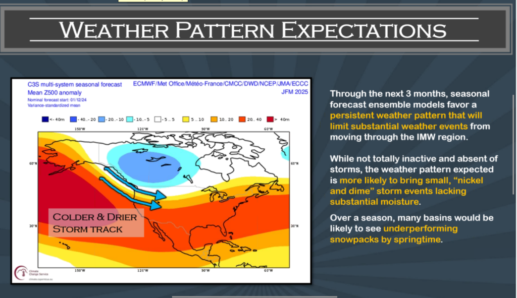
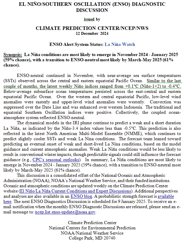
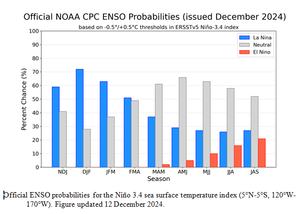
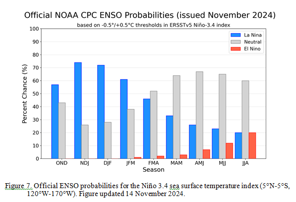
With respect to the long-term part of the Outlook which I call the Four-Season Outlook, the timing of the transition from Neutral to LaNina has been challenging to predict.  We are still in ENSO Neutral. La Nina is the likely scenario soon, but the strength of the La Nina may be fairly weak.

From the NOAA discussion:

“Taken collectively, statistical and dynamical model forecast guidance of the Niño3.4 index favor the development of a weak and most likely short duration La Niña event. Some statistical model forecasts do favor a continuation of ENSO-neutral into and through winter 2024-2025. Dynamical model guidance predictions tend to support weak La Niña conditions to develop, including the majority of participant models from the NMME and C3S forecast suites. Most recent observations and the forecast guidance noted above favor La Niña to emerge during OND 2024 (57% chance) and it is expected to persist through JFM 2025. After JFM 2025, ENSO-neutral is the most likely category into the northern hemisphere summer of 2025.”

“Based on a weak La Nina and models overdoing trends, observed trends become more of the signal. Furthermore, higher frequency patterns (AO, MJO, and stratospheric variability) that result in increased uncertainty can also play a larger role. Those modes are largely not predictable on seasonal timescales,”

I personally would not have total confidence in this outlook given the uncertainty about there actually being a La Nina and its strength if it does happen.  I forecasted the JAMSTEC three-season forecast last Saturday LINK. I do not have a lot of confidence that NOAA knows how to deal with a La Nina Modoki. The number of El Nino and La Nina events since 1950 is a fairly small number. When you further segment them by strength you end up with a very small number of events in each category (El Nino v La Nina and three or four categories of strength within each of perhaps 8  to 10 subcategories. This makes both statistical methods and dynamical models have a large error range.  We are pretty confident now that we will have either a weak La Nina or Neutral with a La Nina bias meaning it will be in the Neutral Range but closer to a La Nina than an El Nino. This suggests that there is value in this forecast. The maps show the level of confidence that NOAA (really the NOAA Climate Prediction Center) has for the outlook shown when they show a part of the U.S. or Alaska differing from normal.

Let’s Take a Look at the (mid-month) Outlook for December.

It will be updated on the last day of November.

Then we look at a graphic that shows both the next month and the next three months.

The top row is what is now called the Mid-Month Outlook for next month which will be updated at the end of this month. There is a temperature map and a precipitation map. The second row is a three-month outlook that includes next month.  I think the outlook maps are self-explanatory. What is important to remember is that they show deviations from the current definition of normal which is the period 1991 through 2020.  So this is not a forecast of the absolute value of temperature or precipitation but the change from what is defined as normal or to use the technical term “climatology”.

Notice that the Outlook for next month and the three-month Outlook are fairly similar except in two places.  This tells us that January and February will be substantially the same as December for most of CONUS and Alaska. Part of the explanation for this is that NOAA expects La Nina to impact all three months.

The full NOAA Seasonal Outlook extends through December/January/February of 2026 (yes that is more than a year out). All of these maps are in the body of the article. Large maps are provided for December and the three-month period December/January/February  Small maps are provided beyond that through December/January/February of 2026 with a link to get larger versions of these maps. NOAA provides a discussion to support the maps. It is included in the body of this article.

In some cases, one will need to click on “read more” to read the full article. For those on my email list where I have sent the url of the article, that will not be necessary.

Weather Outlook for the U.S. for Today Through at Least 22 Days and a Six-Day Forecast for the World: posted November 22, 2024

This article focuses on what we are paying attention to in the next 48 to 72 hours. The article also includes weather maps for longer-term U.S. outlooks (up to four weeks) and a six-day World weather outlook which can be very useful for travelers.

First the NWS Short Range Forecast. The afternoon NWS text update can be found here after about 4 p.m. New York time but it is unlikely to have changed very much from the morning update. The images in this article automatically update.

Short Range Forecast Discussion
NWS Weather Prediction Center College Park MD
Fri Nov 22 2024
Valid 12Z Fri Nov 22 2024 – 12Z Sun Nov 24 2024

…Atmospheric river will produce one last round of heavy rain/mountain
snow and strong wind gusts across the Pacific Northwest today…

…Moderate to heavy snow for portions of the Central Appalachians today...

…Above average temperatures expand across the Central U.S. this
weekend…

Anomalous moisture supported by a deep low pressure system will continue
impacting the Pacific Northwest today. Life threatening flooding is likely
across portions of northern California, where additional amounts of 3-5″
are expected, mainly over coastal areas. As much as 4-10″ of rain are
possible for the northern Sierra Nevada. Dangerous flooding, rock slides
and debris flows remain likely today. A Moderate Risk of Flash Flooding is
in effect for upslope portions of the northern Sierra below 5000′. The
flooding risk will decrease from north to south by later today and into
tonight. Heavy mountain snow is expected over the Washington Cascades and
Northern Rockies through Saturday. Multiple feet of snow are likely to
accumulate over portions of the northern Sierra (above 7000′) by Saturday
evening. Strong winds will continue across coastal areas of northwest
California into western Washington, and over south-central Oregon. These
winds may blow down trees and power lines, and additional power outages
are possible.

A deep upper low will pivot over the Northeast and reinforce a cooler
airmass along with a relatively shallow bit of moisture into the region
today. Some rain and snow showers are expected across much of the
Northeast/northern Mid-Atlantic as a result. Heavier snow will likely
remain confined to the higher terrain of the Central Appalachians, where
between 6-12 inches are expected with locally higher amounts possible.
Snow chances diminish as the day progresses and temperatures rise. Upper
ridging over the Intermountain West and Rockies will shift eastward into
the Central U.S. this weekend where above average temperatures are likely
to follow.

To get your local forecast plus active alerts and warnings click HERE and enter your city, state or zip code.

Learn about wave patterns HERE.

Then, looking at the world and of course, the U.S. shows here also. Today we are looking at precipitation.

Please click on “Read More” below to access the full Daily Report issued today.

Weather Outlook for the U.S. for Today Through at Least 22 Days and a Six-Day Forecast for the World: posted November 21, 2024

This article focuses on what we are paying attention to in the next 48 to 72 hours. The article also includes weather maps for longer-term U.S. outlooks (up to four weeks) and a six-day World weather outlook which can be very useful for travelers.

First the NWS Short Range Forecast. The afternoon NWS text update can be found here after about 4 p.m. New York time but it is unlikely to have changed very much from the morning update. The images in this article automatically update.

Short Range Forecast Discussion
NWS Weather Prediction Center College Park MD
Thu Nov 21 2024
Valid 12Z Thu Nov 21 2024 – 12Z Sat Nov 23 2024

…Strong atmospheric river continues to impact northern California with
heavy rain and life-threatening flooding through Friday…

…Developing storm system forecast to bring another round of gusty winds
to the Pacific Northwest on Friday with heavy mountain snow spreading
toward the northern Rockies this weekend...

…Unsettled weather expected across much of the Northeast and Great Lakes
over the next few days, including the likelihood of heavy snow in the
central Appalachians and higher elevations of northeastern Pennsylvania
and southern New York…

Impactful and for some place dangerous weather conditions will continue
through early this weekend as two separate storm systems impact the Lower
48. Starting in the West, a strong atmospheric river currently impacting
northern California is forecast to remain relatively stationary over the
next few days and produce an additional 6-12 inches of rainfall over
regions with already saturated terrain. The atmospheric river is expected
to peak in intensity today, but with moderate bouts of rain lingering
through much of Friday and snow levels finally lowering somewhat on
Saturday. In the meantime, dangerous flooding, rock slides, and debris
flows are likely, which has prompted a High Risk (level 4/4) of Excessive
Rainfall to be issued across the northern California coastline today. Be
sure to check conditions before traveling and never drive across flooded
roadways.

Aiding the surge of atmospheric moisture into northern California and the
Northwest through the end of the week is a developing storm system
forecast to swing off the Oregon and Washington coastline on Friday. A
punch of gusty winds are expected, mainly along coastal regions, could
produce rough surf and additional isolated power outages. As precipitation
lifts northward and inland along a draped stationary boundary stretching
from the northern Rockies to British Columbia, heavy snow is possible from
the Washington Cascades to the western Montana, Idaho, and northwestern
Wyoming mountain ranges through early Sunday.

November snowfall is also in the forecast for parts of the Northeast and
Great Lakes thanks to a potent upper-level low swinging over the region.
At the surface, a compact area of low pressure is currently looping around
the Great Lakes with an eventual southward trajectory over Lake Michigan
later today. Parts of eastern Wisconsin could see precipitation fall as
snow along with wind gusts up to 40 mph. Winter Weather Advisories have
been issued for snowfall amounts up to 3-4 inches. Meanwhile, a separate
area of low pressure developing near Long Island tonight is also expected
to track in a looping orientation across the Northeast through Friday,
while also producing periods of heavy snow. The greatest chances for at
least 6 inches of snowfall is found across northeast Pennsylvania and
southern New York, including the Pocono and Catskill mountains.
Additionally, a long-duration upslope snow event is underway across the
central Appalachians and anticipated to linger through at least early
Saturday. Up to a foot of snow is possible across the higher terrain of
West Virginia, Maryland, and southwest Pennsylvania. Light snow is also
expected to reach as far south as the higher ranges of North Carolina.

The central and southern U.S. can expect much more tranquil conditions as
high pressure creates a void in the unsettled weather impacting both the
East and West coasts. However, below average temperatures are forecast
from the Mississippi Valley to the Southeast as breezy northwest flow
ushers in a colder airmass. This may lead to early morning frost and/or
freeze potential across the Southeast and Lower Mississippi Valley.

To get your local forecast plus active alerts and warnings click HERE and enter your city, state or zip code.

Learn about wave patterns HERE.

Then, looking at the world and of course, the U.S. shows here also. Today we are looking at precipitation.

Please click on “Read More” below to access the full Daily Report issued today.

Weather Outlook for the U.S. for Today Through at Least 22 Days and a Six-Day Forecast for the World: posted November 20, 2024

This article focuses on what we are paying attention to in the next 48 to 72 hours. The article also includes weather maps for longer-term U.S. outlooks (up to four weeks) and a six-day World weather outlook which can be very useful for travelers.

First the NWS Short Range Forecast. The afternoon NWS text update can be found here after about 4 p.m. New York time but it is unlikely to have changed very much from the morning update. The images in this article automatically update.

Short Range Forecast Discussion
NWS Weather Prediction Center College Park MD
Wed Nov 20 2024
Valid 12Z Wed Nov 20 2024 – 12Z Fri Nov 22 2024

…Back-to-back powerful Pacific storm systems to impact the West Coast
through the end of this week with heavy rain, life-threatening flooding,
strong winds, and higher elevation mountain snow…

…Near blizzard conditions are possible through this evening across the
northern Plains…

…Heavy snow is likely throughout parts of the central Appalachians
beginning on Thursday, with a separate burst of snowfall possible across
northeast Pennsylvania and neighboring regions of the Northeast Thursday
night into Friday...

The active November weather pattern impacting CONUS is forecast to
continue through the end of this week and bring hazardous rain, wind, and
snow for several regions. A significant Pacific storm system and strong
atmospheric river have already started pummeling the West Coast and
Northwest this morning. The very deep low pressure system churning about
300 miles off the coast of Washington is responsible for high winds
impacting much of northern California, Oregon, and Washington. These winds
have already produced numerous power outages, reports of tree damage, and
are expected to create blizzard conditions throughout the Cascades.
Fortunately these winds are expected to gradually subside by midday as the
low pressure system swings away from the region. However, a continuous
plume of ample atmospheric moisture content entering northern California
this morning is forecast to linger through the end of the week and lead to
extreme rainfall totals. Over 10 inches of rainfall across the northern
California coast and inland mountain ranges are likely to increase the
threat of life-threatening flash flooding, rock slides, and debris flows.
As this corridor of heavy rainfall lingers along a stationary boundary
extending into the Pacific Ocean, a separate area of low pressure is
forecast to develop and rapidly strengthen off the Northwest coast on
Friday. This storm will help amplify the atmospheric river streaming into
northern California through Friday morning, exacerbating the flooding
threat. WPC has issued a High Risk (level 4/4) of Excessive Rainfall on
Thursday in order to further highlight this concern. Additionally, another
round of strong winds are anticipated from this second low pressure system
throughout the Northwest to end the week. Residents and visitors residing
or traveling between northern California and Washington are advised to
check road conditions before venturing out, listen to advice from local
officials, review emergency plans, and have multiple ways of receiving
warnings.

For the central U.S. the main weather story will be found throughout the
northern Plains as heavy snow and gusty winds create near blizzard
conditions today. These hazardous weather conditions are resulting from a
slow-moving and gradually weakening low pressure system just north of the
Minnesota-North Dakota border. The greatest snowfall amounts are forecast
across North Dakota, eastern South Dakota, and northwest Minnesota, but
with additional totals today generally under 4 inches. Wind impacts should
be more widespread and extend into eastern Montana and Nebraska as maximum
gusts could exceed 60 mph through tonight. This area of low pressure is
anticipated to rapidly weaken tonight and lead to calmer conditions on
Thursday.

After an extended period of dry and tranquil weather across the Northeast,
the upper level system exiting the northern Plains today will slide
eastward and produce a chance for heavy precipitation in the form of both
rain and snow. The evolution of surface features over the next few days
are forecast to begin with a developing strong and compact low pressure
system over the Great Lakes today, while a cold front quickly pushes
eastward to the Mid-Atlantic by tonight. Showers and maybe a rumble of
thunder may accompany this cold front as rain possibly mixes with snow
spreading across the Great Lakes. By Thursday, a separate area of low
pressure forming along the aforementioned cold front is expected to deepen
and lift northward into the Northeast, while also leading to a blossoming
precipitation shield. Rain is most likely across New England where warmer
air surges from the Atlantic Ocean, but the higher elevations and area
directly underneath the cold upper low pressure system may see
precipitation fall as heavy snow. Probabilities for at least 4 inches of
snow by Friday night are high (70-90%) across northeast Pennsylvania and
the southern Catskill mountains of New York. Impactful snowfall is also
likely to be experienced throughout the Allegheny mountains of West
Virginia, Maryland, and Pennsylvania through the end of the week due to a
longer duration favorable upslope snow setup. Total snowfall amounts in
these higher elevations could add up to a foot.

Elsewhere, high pressure building into the south-central U.S. will create
dry conditions from the lower Mississippi Valley to much of the Plains,
Rockies, and Southwest. The temperature outlook features one final day of
widespread 60s and 70s along the East Coast before a strong cold front
knocks afternoon highs below average through the start of the weekend. The
coldest temperatures when compared to climatology over the next few days
are forecast across the northern Plains (highs in the 20s) and Ohio Valley
(highs in the 30s and 40s).

To get your local forecast plus active alerts and warnings click HERE and enter your city, state or zip code.

Learn about wave patterns HERE.

Then, looking at the world and of course, the U.S. shows here also. Today we are looking at precipitation.

Please click on “Read More” below to access the full Daily Report issued today.

Looking Back at October 2024 Weather for the U.S. and the World – Posted on November 19, 2024

Much of the information in this report comes from the monthly emails I receive from John Bateman. He does public outreach for NOAA and in particular NCEI. I could find the same information and more on the NCEI website but John Bateman produces a good summary so I use it or most of it. I also add additional information from NCEI or other NOAA websites. At the end of the article, I provide links that will get you to the full reports and much additional information.

 My comments if any are in boxes like this one.

I start with the trends of October 2024 Temperature looking at North America and then the World both land and water and land only. There is a graphic for just CONUS but the format is different and it is not as easy to read.

This is the temperature trend for the month of October in North America. It covers a larger geographical area than just CONUS but I find it easier to read. It looks like the October temperature was a record for the month of October.

The temperature for the world, land and ocean did not hit a new record. But the temperature for October this year and last was a lot higher than the trend.

The temperature for the world, (land only) may have hit a new record but was mostly tied with October of last year. Notice that land temperatures increase faster than land and ocean as water takes more energy.

To read the rest of this article some will have to click on “Read More”.

Weather Outlook for the U.S. for Today Through at Least 22 Days and a Six-Day Forecast for the World: posted November 19, 2024

This article focuses on what we are paying attention to in the next 48 to 72 hours. The article also includes weather maps for longer-term U.S. outlooks (up to four weeks) and a six-day World weather outlook which can be very useful for travelers.

First the NWS Short Range Forecast. The afternoon NWS text update can be found here after about 4 p.m. New York time but it is unlikely to have changed very much from the morning update. The images in this article automatically update.

Short Range Forecast Discussion
NWS Weather Prediction Center College Park MD
Tue Nov 19 2024
Valid 12Z Tue Nov 19 2024 – 12Z Thu Nov 21 2024

…Powerful Pacific low pressure system to produce significant high wind
impacts and heavy mountain snow across the Northwest, while a strong
atmospheric river takes aim at northern California by Wednesday…

…Potent storm system over the northern Plains to produce gusty winds and
locally heavy snow throughout the region before a redeveloping area of low
pressure brings unsettled weather to the Great Lakes, central
Appalachians, and Northeast from midweek onward…

…Heavy rain and flash flooding potential continues throughout portions
of the central and eastern Gulf Coast today…

No shortage of active weather across the Nation this week as two separate
strong low pressure systems produce hazardous conditions in the form of
high winds, heavy rain, and snowfall. Starting with the Pacific Northwest,
a rapidly strengthening and extremely powerful low pressure system
forecast to pass roughly 300 miles west of the Olympic Peninsula tonight
is anticipated to begin impacting the region today. Damaging winds with
gusts up to 70 mph are possible across northern California, as well as
parts of Oregon and Washington, with the highest winds expected along the
coast and high terrain. These winds are likely to produce numerous power
outages and tree damage in the most impacted regions. When combined with
heavy snowfall at the higher elevations, blizzard conditions are in the
forecast throughout the Washington Cascades. As an associated frontal
boundary slides southeastward and stalls near northern California on
Wednesday, a deep and continuous plume of anomalous atmospheric moisture
content will flow into the Redwood Coast of California and northern
mountain ranges of the Golden State. Heavy rain and rising snow levels
will increase the threat of numerous floods and potential mudslides,
exacerbated by the duration of heavy rainfall through the end of the week.
In fact, WPC has issued a High Risk (level 4/4) of Excessive Rainfall
across parts of northwest California on Thursday in order to further
highlight this flooding threat. Residents and visitors throughout the
Northwest are urged to have multiple ways to receive warnings, listen to
advice from local officials, and avoid traveling through hazardous weather
conditions if possible.

In the north-central U.S. another potent low pressure system is lifting
northward and producing unsettled weather of its own across the Upper
Midwest and northern Plains today. A tight pressure gradient being
produced by the storm is forecast to create strong winds across much of
Nebraska, eastern Montana, and the Dakotas through Wednesday with maximum
wind gusts up to 65 mph possible. Strong winds may also overlap with
moderate to locally heavy snow throughout North Dakota and northwest
Minnesota as the storm system stalls tonight over south-central Canada.
Probabilities for at least 6 inches of total snowfall are high (>70%)
across northern North Dakota. Meanwhile, scattered showers are forecast to
spread eastward into the Midwest, Great Lakes, and eventually the
Mid-Atlantic ahead of an advancing cold front today. By Wednesday night, a
redeveloping low pressure system rapidly strengthening over the Great
Lakes will help produce another round of precipitation over the Great
Lakes, central Appalachians and Northeast through the end of the week. The
greatest impacts from this precipitation is expected throughout the higher
elevations of West Virginia and western Maryland, where up to a foot of
snowfall is possible through Friday.

Elsewhere, heavy rain and a risk for scattered flash floods remains a
concern across the central and eastern Gulf Coast as a cold front, weak
area of low pressure, and ample atmospheric moisture content spark
numerous showers and thunderstorms capable of containing intense rainfall
rates through tonight. The greatest risk for flash flooding specifically
exists from far eastern Louisiana to the western Florida Panhandle, with
urban and poor drainage regions most susceptible to rapid water rises.

Temperatures will be on a roller coaster ride this week as well above
average temperatures are found in the East before an advancing cold front
knocks readings down below average by Thursday. Meanwhile, cooler
temperatures over much of the West are forecast to return to near normal
as upper ridging builds into place.

To get your local forecast plus active alerts and warnings click HERE and enter your city, state or zip code.

Learn about wave patterns HERE.

Then, looking at the world and of course, the U.S. shows here also. Today we are looking at precipitation.

Please click on “Read More” below to access the full Daily Report issued today.

Weather Outlook for the U.S. for Today Through at Least 22 Days and a Six-Day Forecast for the World: posted November 18, 2024

This article focuses on what we are paying attention to in the next 48 to 72 hours. The article also includes weather maps for longer-term U.S. outlooks (up to four weeks) and a six-day World weather outlook which can be very useful for travelers.

First the NWS Short Range Forecast. The afternoon NWS text update can be found here after about 4 p.m. New York time but it is unlikely to have changed very much from the morning update. The images in this article automatically update.

Short Range Forecast Discussion
NWS Weather Prediction Center College Park MD
Mon Nov 18 2024
Valid 12Z Mon Nov 18 2024 – 12Z Wed Nov 20 2024

…A potent storm system over the central U.S. today will create chances
for heavy rainfall, severe thunderstorms, and gusty winds, while moderate
snowfall is possible across the northern Plains by Tuesday…

…Heavy rain and flash flooding potential exists throughout the central
and eastern Gulf Coast over the next few days…

…Powerful Pacific low pressure system to impact the Northwest with high
winds and heavy mountain snow, while an atmospheric river takes aim at
northern California by Wednesday…

An amplified weather pattern and two separate strong storm systems are set
to impact the Nation during the first half of this week. First, a deep low
pressure system ejecting out of West Texas early this morning is
anticipated to further organize over the central U.S. today and produce
areas of heavy rain, severe weather, and gusty winds to the
southern/central Plains. Thunderstorms forming along an attached cold
front may contain damaging winds and perhaps a few tornadoes between
central Oklahoma and North Texas today. This region is where the Storm
Prediction Center has hoisted a Slight Risk (level 2/5) of severe
thunderstorms. As the system progresses northward into the Upper Midwest
on Tuesday, showers are also forecast to spread north throughout parts of
the Midwest and Great Lakes. Meanwhile, cold air working into the western
side of the storm will likely allow for precipitation to fall as snow
across parts of North Dakota and northern Minnesota into Wednesday.
Snowfall may also be accompanied by gusty winds, leading to lower
visibility on roadways. Current snowfall probabilities for at least 4
inches of snow are greatest (70-90%) across north-central North Dakota.

As the associated cold front pushes eastward through Tuesday, numerous
showers and thunderstorms interacting with a surge of moisture being
lifted northward from the Gulf of Mexico could contain intense rainfall
rates capable of producing flash flooding. Heavy rainfall is most likely
tonight across eastern Louisiana and southern Mississippi, with the threat
expanding east to the Florida Panhandle on Tuesday. Scattered flash floods
are most likely throughout low-lying and urban regions. Residents and
visitors are reminded to have multiple ways to receive warnings and never
drive across flooded roadways.

For much of the Northwest, northern Great Basin, and northern Rockies, a
cold front pushing across the region today and enhanced onshore flow will
allow for unsettled weather to continue ahead of a powerful storm system
forecast to develop off the coast of the Northwest on Tuesday. This
appetizer of precipitation to start the workweek will mainly include the
potential for moderate to heavy snowfall across the Cascades and northern
Rockies. However, by Tuesday night the rapidly strengthening Pacific low
pressure system will aid in producing high winds across the Pacific
Northwest and increasing precipitation intensity. Wind gusts up to 70 mph
are possible across parts of northern California and Oregon, with strong
winds also expected over parts of western Washington. These winds will
have the potential to knock down trees and produce power outages. Heavy
snowfall with amounts potentially exceeding two feet are possible over the
northern California ranges and Cascades. By Wednesday, an associated
atmospheric rive event is expected to take shape and direct continuous
Pacific moisture towards northern California and southwest Oregon.
Widespread rainfall amounts of 4 to 7 inches are expected through
Wednesday across this region, which could produce areas of river flooding
and increase the risk of mudslides. Heavy rain and the associated weather
hazards from this atmospheric river event are also expected to continue
beyond midweek.

Below average temperatures are forecast to remain over much of the western
U.S. over the next few days while gradually spreading eastward into the
Great Plains. Meanwhile, high pressure over the East will continue to
create mild and dry conditions through Tuesday as rainfall chances enter
the Mid-Atlantic and Northeast on Wednesday.

To get your local forecast plus active alerts and warnings click HERE and enter your city, state or zip code.

Learn about wave patterns HERE.

Then, looking at the world and of course, the U.S. shows here also. Today we are looking at precipitation.

Please click on “Read More” below to access the full Daily Report issued today.