Drought Update – January 27, 2024

Every week on Thursday, the Drought Monitor LINK is updated for every state in the U.S. plus most territories.


And there is another source of information on drought from certain groupings of states that operate what is called a Drought Early Warming System (DEWS). They sometimes have webinars and may issue reports without having a webinar. Not all parts of the U.S. are covered. These groups of states seem to issue reports every two months. I am only showing the recent reports since a month-old report at this time of the year can be misleading.

To get to that part of this article where I provide these reports you may have to click on “Read More”. I provide maps for all of the existing DEWS.  And other groups of states report on precipitation, streamflow, and reservoir status which overlaps a lot with what is covered by the DEWS. So I plan to write about the activity of both kinds of groups. Today I am focusing on the DEWS.

Short Term and Intermediate-Term Weather Outlooks for the U.S. and a Six-Day Forecast for the World: posted January 27, 2024

This article focuses on what we are paying attention to in the next 48 to 72 hours. The article also includes weather maps for longer-term U.S. outlooks and a six-day World weather outlook which can be very useful for travelers.

First the highlights from the NWS.

Short Range Forecast Discussion
NWS Weather Prediction Center College Park MD
Sat Jan 27 2024
Valid 12Z Sat Jan 27 2024 – 12Z Mon Jan 29 2024

…Heavy snow and rain/freezing rain over parts of Northern New England
and snow over parts of the Appalachians on Sunday…

…There is a Slight Risk of excessive rainfall over parts of the
Central/Southern Appalachians and Mid-Atlantic on Saturday…

…There is a Slight Risk of severe thunderstorms over parts of the
Southeast on Saturday…

Looking out a bit farther and focusing on the more series events:


Looking at the world and of course, the U.S. shows here also. This evening we are looking at precipitation and the baseline here is such that it will tend to show warmer than baseline-normal precipitation due to the trend in temperatures.

Please click on “Read More” below to access the full report issued today.

Short Term and Intermediate-Term Weather Outlooks for the U.S. and a Six-Day Forecast for the World: posted January 26, 2024

This article focuses on what we are paying attention to in the next 48 to 72 hours. The article also includes weather maps for longer-term U.S. outlooks and a six-day World weather outlook which can be very useful for travelers.

First the highlights from the NWS.

Short Range Forecast Discussion
NWS Weather Prediction Center College Park MD
Fri Jan 26 2024
Valid 12Z Fri Jan 26 2024 – 12Z Sun Jan 28 2024

..Heavy rain/freezing rain over parts of Northern New England; light
Rain/Freezing Rain over parts of the Pacific Northwest…

…Light snow for the Cascades and higher elevation snow across the
Central/Southern Rockies and Southwest; Moderate snow over Northern New
England…

…There is a Slight Risk of excessive rainfall over parts of the Pacific
Northwest Coast on Friday and the Central Gulf Coast into the
Central/Southern Appalachians and Mid-Atlantic on Friday and Saturday…

Looking out a bit farther and focusing on the more series events:


Looking at the world and of course, the U.S. shows here also. This evening we are looking at precipitation and the baseline here is such that it will tend to show warmer than baseline-normal precipitation due to the trend in temperatures.

Please click on “Read More” below to access the full report issued today.

Short Term and Intermediate-Term Weather Outlooks for the U.S. and a Six-Day Forecast for the World: posted January 25, 2024

This article focuses on what we are paying attention to in the next 48 to 72 hours. The article also includes weather maps for longer-term U.S. outlooks and a six-day World weather outlook which can be very useful for travelers.

First the highlights from the NWS.

Short Range Forecast Discussion
NWS Weather Prediction Center College Park MD
Thu Jan 25 2024
Valid 12Z Thu Jan 25 2024 – 12Z Sat Jan 27 2024

…Flash Flooding and Severe Weather concerns continue for portions of the
Southern Plains, Gulf Coast, Lower Mississippi Valley and Southeast…

…Freezing rain impacts possible over parts of southern Maine/central New
England…

…Unseasonably warm air surges into the eastern third of the country
leading to widespread record low temperatures Thursday night…[Editor’s Note: not clear. It should say the low of the day will be warm enough to break records]

Looking out a bit farther


Looking at the world and of course, the U.S. shows here also. This evening we are looking at temperatures and the baseline here is such that it will tend to show warmer than baseline-normal temperatures due to the trend in temperatures.

Please click on “Read More” below to access the full report issued today.

The polar vortex is acting up – January 24, 2024

Last month there was some concern that we were having a Sudden Stratospheric Warming Event. It seems that it did happen but in a fairly minor way and the resulting cold intrusions of Arctic air seem to have not lasted for very long. I came across this posted article on Climate.Gov attributed to Laura Cisto and Amy Butler. I am reproducing their article here except for the comments it received. You can access the article with the comments HERE. The comments are always quite interesting and the authors typically reply to those comments. And that process can continue for some time which is why I have provided the link to the Post by Laura Cisto and Amy Butler.

It is difficult reading and not everyone will want to dig into it but it is here for those with a deep interest in weather. Where I have comments, I have put them in boxes within the article. For those with an insatiable curiosity, THIS explanation of Sudden Stratospheric Warming Events will probably quench your thirst.  The blog post that I have in this article describes a recent mini-SSW event that was somewhat unusual.


To read the full article you may need to click on “Read More”.

Short Term and Intermediate-Term Weather Outlooks for the U.S. and a Six-Day Forecast for the World: posted January 24, 2024

This article focuses on what we are paying attention to in the next 48 to 72 hours. The article also includes weather maps for longer-term U.S. outlooks and a six-day World weather outlook which can be very useful for travelers.

First the highlights from the NWS.

…Heavy rainfall and concerns for flash flooding for portions of the
Lower Mississippi Valley, Tennessee Valley and Gulf states through Friday
morning…

…A swath of freezing rain and some accumulating snowfall will impact
portions of the Midwest, Lower Great Lakes, and the Northeast…

…Much milder air with temperatures surging well above normal can be
expected through the middle of the week for much of the eastern half of
the country..

Looking out a bit farther


Looking at the world and of course, the U.S. shows here also.

Please click on “Read More” below to access the full report issued today.

Short Term and Intermediate-Term Weather Outlooks for the U.S. and a Six-Day Forecast for the World: posted January 23, 2024

This article focuses on what we are paying attention to in the next 48 to 72 hours. The article also includes weather maps for longer-term U.S. outlooks and a six-day World weather outlook which can be very useful for travelers.

First the highlights from the NWS.

Short Range Forecast Discussion
NWS Weather Prediction Center College Park MD
Tue Jan 23 2024
Valid 12Z Tue Jan 23 2024 – 12Z Thu Jan 25 2024

…Heavy rainfall and concerns for flash flooding will exist through
Thursday morning across the Lower Mississippi Valley…

…A swath of freezing rain and some accumulating snowfall will impact
portions of the Midwest, Lower Great Lakes, and the Northeast…

…Much milder air with temperatures surging well above normal can be
expected by the middle of the week for much of the eastern half of the
country…

Please click on “Read More” below to access the full report issued today.

Short Term and Intermediate-Term Weather Outlooks for the U.S. and a Six-Day Forecast for the World: posted January 22, 2024

This article focuses on what we are paying attention to in the next 48 to 72 hours. The article also includes weather maps for longer-term U.S. outlooks and a six-day World weather outlook which can be very useful for travelers.

First the highlights from the NWS.

Short Range Forecast Discussion
NWS Weather Prediction Center College Park MD
Mon Jan 22 2024
Valid 12Z Mon Jan 22 2024 – 12Z Wed Jan 24 2024

…More unsettled weather expected to impact the West Coast with heavy
rain impacting California today…

…Freezing rain across the central Plains this morning is expected to
rapidly spread northeastward into the Midwest today followed by another
round of freezing rain tonight from the Midwest to the lower Great Lakes…

…Accumulating snowfall across the lower Great Lakes on Tuesday…

…A couple rounds of heavy rain will raise flooding potential across
eastern Texas today, expanding east into the lower Mississippi Valley
Tuesday into early Wednesday…
 

Please click on “Read More” below to access the full report issued today.

Short Term and Intermediate-Term Weather Outlooks for the U.S. and a Six-Day Forecast for the World: posted January 21, 2024

This article focuses on what we are paying attention to in the next 48 to 72 hours. The article also includes weather maps for longer-term U.S. outlooks and a six-day World weather outlook which can be very useful for travelers.

First the highlights from the NWS.

Short Range Forecast Discussion
NWS Weather Prediction Center College Park MD
Sun Jan 21 2024
Valid 12Z Sun Jan 21 2024 – 12Z Tue Jan 23 2024

…Heavy precipitation moving across California today and again on
Monday…

…Heavy rain expected to develop over southern Texas later today,
shifting east into eastern Texas and Louisiana on Monday…

…Freezing rain and sleet to impact Oklahoma and Kansas this evening,
spreading into the Midwest on Monday, following by wet snow across the
upper Midwest and into the Great Lakes by Tuesday morning…
 

Please click on “Read More” below to access the full report issued today.

Colorado River Basin January 17, 2024 Water Supply Forecast Discussion – Posted January 20, 2024

The mission of the National Weather Service Colorado Basin River Forecast Center (CBRFC) is to produce river, flood, and water supply forecasts for the Colorado Basin and the Great Basin in support of saving lives and property and to enhance the region’s environment and economy.

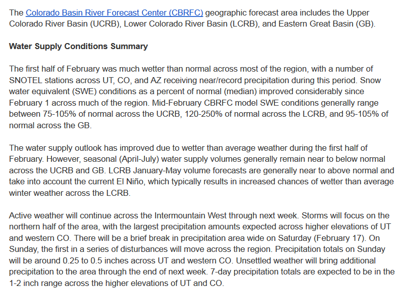
In this article, I am providing a summary of their Water Supply Forecast Discussion released on January 17, 2024.  The situation is not very good. However due to a wet winter last winter, the reservoirs are mostly in good shape. 


I have also included information on the current reservoir storage levels including a few that are outside of the Colorado River Basin.

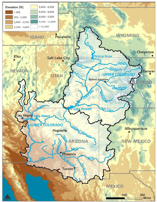
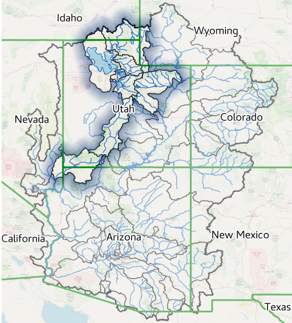
The image below shows part of the area covered in the CBRFC Report.  The map shown here is only the Colorado Basin. The Eastern Great Basin is to the west of this map. The maps shown in the article cover both basins but are not as scenic as this map.

Map showing both the Colorado Basin and Eastern Great Basin.

Most of the information presented in this part of the article is from a summary report (Link) issued by the Colorado River Basin Forecast Center. January 17, 2023, Water Supply Forecast Discussion
The Colorado Basin River Forecast Center (CBRFC) geographic forecast area includes the Upper Colorado River Basin (UCRB), Lower Colorado River Basin (LCRB), and Eastern Great Basin (GB). It is one of many similar organizations within the National Weather Service. They are all different. In the future, I will try to pay more attention to some of the other River Forecasting Centers but they do not all go out of their way to provide reports to the Media. But the Colorado River is a special situation in a way due to the problems complying with the Colorado River Compact. But all our rivers are important.

At this time of the year,  we are hopefully adding to the snowpack for future snowmelt. Additional information is available on the Center website (click HERE), there are certain graphics that update daily. And now I provide the main part of their new forecast discussion summary. I am copying directly from their document. My comments are in boxes.


The CBRFC weather forecast is for a changing weather pattern.  For updated weather forecasts go to econcurrents.com 

and look for the most recent Short-Term and Intermediate-Term Weather Outlooks article in the list of Recent Posts.

Please click on “Read More” to read the rest of this article.