Today Through the Fourth Friday (22 to 28 days) Weather Outlook for the U.S. and a Six-Day Forecast for the World: posted February 23, 2024

It is difficult to find a more comprehensive Weather Outlook anywhere else with the ability to get a local 10-day Forecast also.

This article focuses on what we are paying attention to in the next 48 to 72 hours. The article also includes weather maps for longer-term U.S. outlooks and a six-day World weather outlook which can be very useful for travelers.

First the NWS Short Range Forecast. The afternoon NWS text update can be found here but it is unlikely to have changed very much. The images in this article automatically update.

Short Range Forecast Discussion
NWS Weather Prediction Center College Park MD
Fri Feb 23 2024
Valid 12Z Fri Feb 23 2024 – 12Z Sun Feb 25 2024

…Light snow over parts of Northern New England on Saturday…

…Light snow over parts of the Upper Midwest to the Central
Appalachians…

…Rain along the East Coast from the Mid-Atlantic to the Southeast on
Saturday…

A front along the East Coast will move eastward off the East Coast by
Friday evening. The system will create snow over parts of Northern New
England and rain over Southern New England through Friday evening. In
addition, showers and thunderstorms will develop over parts of the
Southeast through late Friday night.

Meanwhile, a second front extending from the Upper Great Lakes to the
Northern Plains will move southward to the Gulf Coast States by Sunday and
eastward off the Northeast Coast by Saturday morning. A wave of low
pressure over southern Wisconsin will move southeastward to the Central
Appalachians by Saturday. On Friday, the system will produce light snow
over parts of the Northern Plains, Upper Mississippi Valley, and Upper
Great Lakes. Overnight Friday, the slight snow will move into parts of the
Ohio Valley and the Lower Great Lakes into parts of the Northeast. On
Saturday light snow will develop over parts of the Central Appalachians
and Southern Appalachians overnight Saturday. Light rain will develop over
parts of the southern Mid-Atlantic overnight Saturday, ending by Sunday.

Furthermore, upper-level energy moving over the Pacific Northwest to the
Northern Plains will create light snow over parts of the Northern
Intermountain Region/Northern Rockies through Saturday evening. A third
front will also move southward out of South-Central Canada into the
northern Plains/Upper Mississippi Valley by Sunday morning. Scattered
light snow will develop over parts of the Northern High Plains overnight
Saturday.

To get your local forecast plus active alerts and warnings click HERE and enter your city, state or zip code.

Above is a 72 hour animation of the forecast. Learn about wave patterns HERE.

Then, looking at the world and of course, the U.S. shows here also. Today we are looking at precipitation.

Please click on “Read More” below to access the full report issued today.

Colorado River Basin Mid-February, 2024 Water Supply Forecast Discussion – Posted February 22, 2024

The mission of the National Weather Service Colorado Basin River Forecast Center (CBRFC) is to produce river, flood, and water supply forecasts for the Colorado Basin and the Great Basin in support of saving lives and property and to enhance the region’s environment and economy.

In this article, I am providing a summary of their Water Supply Forecast Discussion released on January 17, 2024.  The situation is not very good. However, due to a wet winter last winter, the reservoirs are mostly in good shape.

I have also included information on the current BOR reservoir storage levels including some that are outside of the Colorado River Basin.

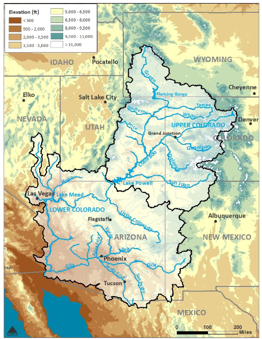
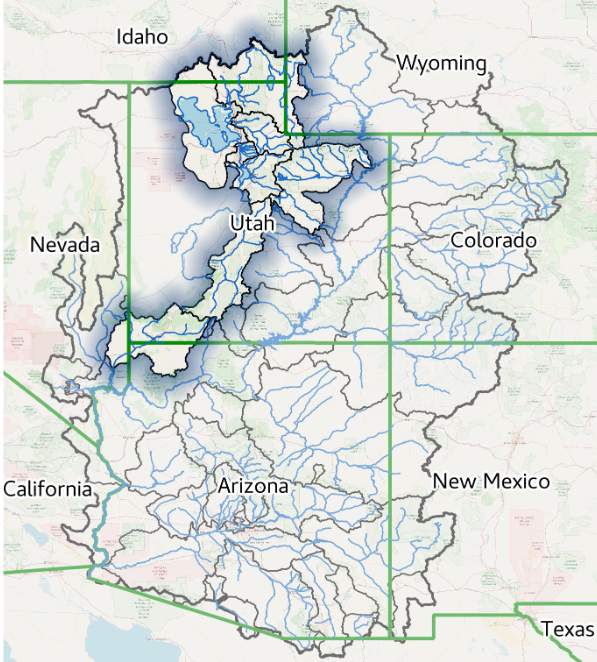
The image below shows part of the area covered in the CBRFC Report.  The map shown here is only the Colorado Basin. The Eastern Great Basin is to the west of this map. The maps shown in the article cover both basins but are not as scenic as this map.

Map showing both the Colorado Basin and Eastern Great Basin.

Most of the information presented in this part of the article is from a summary report (Link) issued by the Colorado River Basin Forecast Center. February 16, 2024, Water Supply Forecast Discussion
The Colorado Basin River Forecast Center (CBRFC) geographic forecast area includes the Upper Colorado River Basin (UCRB), Lower Colorado River Basin (LCRB), and Eastern Great Basin (GB). It is one of many similar organizations within the National Weather Service. They are all different. In the future, I will try to pay more attention to some of the other River Forecasting Centers but they do not all go out of their way to provide reports to the Media. But the Colorado River is a special situation in a way due to the problems complying with the Colorado River Compact. But all our rivers are important.

At this time of the year,  we are still hopefully adding to the snowpack for future snowmelt. Additional information is available on the Center website (click HERE), there are certain graphics that update daily. And now I provide the main part of their new forecast discussion summary. I am copying directly from their document. My comments are in boxes. At the end of the report I provide addition “Tea Cup” diagrams of many USBOR Reservoirs. I also provide two very interesting forecasts for two of the most import reservoirs Lake Powell and Lake Mead.


The CBRFC weather forecast is for a changing weather pattern.  For updated weather forecasts go to econcurrents.com 

and look for the most recent “Today Through the Fourth Friday (22 to 28 days) Weather Outlook for the U.S.” in the list of Recent Posts.

Please click on “Read More” to read the rest of this article.

Today Through the Fourth Friday (22 to 28 days) Weather Outlook for the U.S. and a Six-Day Forecast for the World: posted February 22, 2024

It is difficult to find a more comprehensive Weather Outlook anywhere else with the ability to get a local 10-day Forecast also.

This article focuses on what we are paying attention to in the next 48 to 72 hours. The article also includes weather maps for longer-term U.S. outlooks and a six-day World weather outlook which can be very useful for travelers.

First the NWS Short Range Forecast. The afternoon NWS text update can be found here but it is unlikely to have changed very much. The images in this article automatically update.

Short Range Forecast Discussion
NWS Weather Prediction Center College Park MD
230 AM EST Thu Feb 22 2024

Valid 12Z Thu Feb 22 2024 – 12Z Sat Feb 24 2024

…Pleasantly mild across most of the country through the end of the
week…

…Showers and thunderstorms from the Gulf Coast to the Ohio Valley on
Thursday…

Showers and thunderstorms are forecast to develop across the Ohio Valley
and the Mid-South during the day on Thursday ahead of an approaching cold
front. The greatest rainfall totals with this event are expected roughly
from northern Kentucky to western Pennsylvania, where the combination of
moisture and atmospheric forcing will be the greatest. Isolated to
scattered coverage is expected across much of the Southeast U.S. and into
the Mid-Atlantic region, and possibly some mixed precipitation across
interior portions of the Northeast U.S. and snow for northern New England
going into Thursday night and Friday. Improving weather conditions are
likely by late Friday for most of the East Coast as the cold front moves
offshore.

It will feel more like March and early April across much of the nation to
close out the week, especially across the Plains and Midwest where highs
could easily be 10-20 degrees above late February averages. Widespread
60s and 70s will be common from Texas to the Deep South both Thursday and
Friday, and 50 degree highs could reach as far north as southern Minnesota
and southern Wisconsin on Thursday. A return to reality arrives in time
for the weekend as a cold front from central Canada brings more
January-like readings for the northeastern quadrant of the nation, while
the Great Plains continue to remain mild.

Elsewhere across the continental U.S., a mainly dry weather pattern can be
expected through Saturday with perhaps a few snow showers across portions
of the central and northern Rockies, and rain showers for portions of
western Oregon and Washington on Thursday. There may also be a few light
snow showers with the cold front crossing the Ohio Valley region Friday
night and the central Appalachians on Saturday, but nothing major
expected. Elevated fire weather conditions are forecast by the Storm
Prediction Center across portions of southwestern Texas owing to increased
winds and low humidity in the vicinity of a cold front passing though the
region.

To get your local forecast plus active alerts and warnings click HERE and enter your city, state or zip code.

Above is a 72 hour animation of the forecast. Learn about wave patterns HERE.

Then, looking at the world and of course, the U.S. shows here also. Today we are looking at precipitation.

Please click on “Read More” below to access the full report issued today.

Today Through the Fourth Friday (22 to 28 days) Weather Outlook for the U.S. and a Six-Day Forecast for the World: posted February 21, 2024

It is difficult to find a more comprehensive Weather Outlook anywhere else with the ability to get a local 10-day Forecast also.

This article focuses on what we are paying attention to in the next 48 to 72 hours. The article also includes weather maps for longer-term U.S. outlooks and a six-day World weather outlook which can be very useful for travelers.

First the NWS Short Range Forecast. The afternoon update can be found here if I have not updated it.

Short Range Forecast Discussion
NWS Weather Prediction Center College Park MD
Wed Feb 21 2024
Valid 12Z Wed Feb 21 2024 – 12Z Fri Feb 23 2024

…Rain and snow impacts across California come to an end today…

…Above average temperatures across the lower 48 into late week…

…Critical Fire Weather day over portions of the Southern High Plains on
Wednesday…

Rain and snow showers will gradually weaken across the state of California
today before coming to an end tonight. In the meantime, snow showers will
produce 6-12 inches of new snow for the Intermountain West and Central
Rockies. Surface cyclogenesis over the lee of the Rockies will support
strong west/southwesterly winds carrying dry air out of the Southwest and
into the Southern High Plains this afternoon. Thus, the Storm Prediction
Center issued a Critical Risk of Fire Weather over portions of
southeastern New Mexico into far western Texas.

The upper-level trough responsible for the unsettled weather in the West
will quickly move across the Rockies today and into the Plains by
Thursday. This will spawn a low pressure system over the Central/Southern
Plains which will tap some moisture from the Gulf of Mexico as it moves
across the Mississippi Valley. This interaction will produce rain showers
and scattered thunderstorms across the Midwest/Ohio Valley on Thursday.

Meanwhile, an upper ridge will generate temperatures that are well above
average across the Plains and Mississippi Valley today. Temperatures will
be anywhere from 20-30 degrees above average in these areas. Southerly
flow will send mild temperatures streaming into the East Coast on Thursday
ahead of the approaching low pressures system. The Florida peninsula will
remain below average temperature-wise through the end of the week.

To get your local forecast plus active alerts and warnings click HERE and enter your city, state or zip code.

Above is a 72 hour animation of the forecast. Learn about wave patterns HERE.

Then, looking at the world and of course, the U.S. shows here also. Today we are looking at precipitation.

Please click on “Read More” below to access the full report issued today.

Looking Back at Weather for the U.S. and World in January 2024 Posted on February 20, 2024

Much of the information in this report comes from the monthly emails I receive from John Bateman. He does public outreach for NOAA and in particular NCEI. I could find the same information and more on the NCEI website but John Bateman produces a good summary so I use it or most of it. I also usually add additional information from NCEI or other NOAA websites. The full NCEI report can be accessed HERE.

Arctic air mass brought bitter cold and snow to much of the nation in mid-January
Powerful storms brought heavy rainfall and flooding to parts of the southern Plains

                                                                                           Contact
                                                                                                John Bateman, john.jones-bateman@noaa.gov, 202-424-0929

                                                                                           February 8, 2024


                                                                                          Earth had another record-warm month
                                                                                         It was also the second-wettest January on record Contact
                                                                                              John Bateman, john.jones-bateman@noaa.gov, 202-424-0929

                                                                                         February 14, 2024


I start with the U.S. Key Points

  • The arctic air mass from January 14–18 broke nearly 2,500 daily minimum temperatures county records from the Northwest to the Lower Mississippi Valley.

  • On January 22–25, heavy rainfall brought more than a month’s worth of rain and life-threatening flooding to parts of Texas and Louisiana.

  • January 2024 was the 10th-wettest January on record for the nation, and temperature ranked in the middle third of the historical record for the month.

And then the Global Key Points

  • Temperatures were above average over much of the globe, but the eastern United States, most of Europe and a few other areas were cooler than average.

  • There is a 22% chance that 2024 will be the warmest year in NOAA’s 175-year record and a 79% chance that El Niño will transition to neutral conditions by mid-year.

  • Northern Hemisphere snow cover was near average, but Antarctic sea ice extent was fifth lowest on record for January.

  • Global precipitation was nearly record-high in January, following on the heels of a record-wet December.

I added the below to what John Bateman provided.


January 2024 was a busy month


This is the temperature trend for CONUS. There was a decrease for January in 2024


The temperature for the world, land and water hit a new record, but when looking at land alone it was not a new record.

To read the rest of this article some will have to click on “Read More”.

Today Through the Fourth Friday (22 to 28 days) Weather Outlook for the U.S. and a Six-Day Forecast for the World: posted February 20, 2024

It is difficult to find a more comprehensive Weather Outlook anywhere else with the ability to get a local 10-day Forecast also.

This article focuses on what we are paying attention to in the next 48 to 72 hours. The article also includes weather maps for longer-term U.S. outlooks and a six-day World weather outlook which can be very useful for travelers.

First the NWS Short Range Forecast. The afternoon update can be found here if I have not updated it.

Short Range Forecast Discussion
NWS Weather Prediction Center College Park MD
Tue Feb 20 2024
Valid 12Z Tue Feb 20 2024 – 12Z Thu Feb 22 2024

…Heavy rain and heavy mountain snow in California are expected to become
less intense…

…A Moderate Risk of Excessive Rainfall remains in effect along portions
of coastal southern California today…

…Warming trend expected to expand from the Great Plains into the Midwest
through midweek…

Heavy rain, snow, high winds and thunderstorm impacts will gradually
diminish across California today, as the upper trough supporting them
pushes farther inland. A quasi-stationary front will be the focus for
additional heavy rainfall over southern California today. A Moderate Risk
of Excessive Rainfall leading to Flash Flooding (level 3/4) is in effect
for portions of Los Angeles and Orange Counties where between 1-3 inches
of rain are possible. Higher totals are expected along the immediate coast
and favored terrain of the Transverse Ranges. A broader Slight Risk area
(level 2/4) is in effect from Humboldt County down to San Diego, as well
as the Sacramento Valley and adjacent upslope areas of the Sierra.
Additional accumulations of 6-12 inches of snow are expected for the
Sierra, while 1-2 feet are likely over the Shasta Siskiyous today.
Persistent troughing and upsloping will support moderate to heavy snow
over the Intermountain West where generally between 6-12 inches of snow
can be expected. This snowfall is likely to continue into Wednesday and
expand in coverage into the Central Rockies.

Elsewhere, the ongoing warming trend is expected to continue across the
Great Plains and Mississippi Valley through Wednesday before moderating a
bit and resurging once again heading into the weekend. High temperatures
will be 15-25 degrees above average today and Wednesday over the Great
Plains and Mississippi Valley while mild air shift slowly into the Midwest
and East Coast. The Florida Peninsula will remain below average
temperature-wise due to a deepening upper trough in the western Atlantic.
A developing low pressure system will bring showers and thunderstorms to
the Midwest on Thursday.

To get your local forecast plus active alerts and warnings click HERE and enter your city, state or zip code.

Above is a 72 hour animation of the forecast. Learn about wave patterns HERE.

Then, looking at the world and of course, the U.S. shows here also. Today we are looking at precipitation.

Please click on “Read More” below to access the full report issued today.

Today Through the Fourth Friday (22 to 28 days) Weather Outlook for the U.S. and a Six-Day Forecast for the World: posted February 19, 2024

It is difficult to find a more comprehensive Weather Outlook anywhere else with the ability to get a local 10-day Forecast also.

This article focuses on what we are paying attention to in the next 48 to 72 hours. The article also includes weather maps for longer-term U.S. outlooks and a six-day World weather outlook which can be very useful for travelers.

First the NWS Short Range Forecast. The afternoon update can be found here if I have not updated it.

Short Range Forecast Discussion
NWS Weather Prediction Center College Park MD
251 AM EST Mon Feb 19 2024

Valid 12Z Mon Feb 19 2024 – 12Z Wed Feb 21 2024

…There’s a Moderate risk of excessive rainfall along coastal southern
California today…

…Heavy Snow likely over Sierra Nevada and Shasta Siskiyous in
California…

…Warming trend expected to expand across the Great Plains through
midweek…

A potent upper-level low will continue directing subtropical moisture over
much of California today. Heavy coastal and low elevation rain,
thunderstorms, heavy mountain snow and high winds are all expected from
this Atmospheric River event. Excessive Rainfall leading to Flash Flooding
is possible for much of the state today. A Slight Risk of Excessive
Rainfall (level 2/4) is in effect from Humboldt to Orange County as well
as over parts of the Sacramento Valley and along upslope portions of the
Sierra. A Slight Risk of Severe Thunderstorms is in effect for parts of
the Sacramento Valley where an isolated tornado will be possible. A
targeted Moderate Risk of Excessive Rainfall is in effect for Santa
Barbara and Ventura where heavy rainfall will focus, especially over
elevated terrain. Heavy Snow will blanket the Sierra Nevada and Shasta
Siskiyous today as well, with those mountains forecast to receive 1-3 feet
(isolated higher) of snow by Tuesday morning.

The moisture feed into California will weaken considerably and sag south
on Tuesday, but the threat of Flash Flooding will persist across southern
California, in particular. Upslope flow into the Transverse ranges will
support a renewed threat of Flash Flooding. A Slight Risk of Excessive
Rainfall is in effect from Humboldt down through San Diego County on
Tuesday mainly due to sensitive soils from today’s heavy rain. Up to a
foot of additional snow accumulations with locally higher amounts are
possible over the Sierra and Shasta Siskiyous on Tuesday. Damaging wind
gusts should continue into Wednesday morning before gradually weakening.

Elsewhere, lake effect snow will come to an end this afternoon across the
Lower Great Lakes. Upper level ridging with embedded shortwave energy will
support a warming trend acrosss the Great Plains and Mississippi Valley
through midweek when anomalous temperatures are expected to reach their
peak for the week. High temperatures will be between 15-25 degrees above
average by Wednesday over much of the central U.S..

To get your local forecast plus active alerts and warnings click HERE and enter your city, state or zip code.

Above is a 72 hour animation of the forecast. Learn about wave patterns HERE.

Then, looking at the world and of course, the U.S. shows here also. Today we are looking at precipitation.

Please click on “Read More” below to access the full report issued today.

Today Through the Fourth Friday (22 to 28 days) Weather Outlook for the U.S. and a Six-Day Forecast for the World: posted February 18, 2024

It is difficult to find a more comprehensive Weather Outlook anywhere else with the ability to get a local 10-day Forecast also.

This article focuses on what we are paying attention to in the next 48 to 72 hours. The article also includes weather maps for longer-term U.S. outlooks and a six-day World weather outlook which can be very useful for travelers.

First the NWS Short Range Forecast. The afternoon update can be found here if I have not updated it.

Short Range Forecast Discussion
NWS Weather Prediction Center College Park MD
Sun Feb 18 2024
Valid 12Z Sun Feb 18 2024 – 12Z Tue Feb 20 2024

…There’s a Moderate Risk of Excessive Rainfall leading to Flash Flooding
over portions of Southern California…

…Heavy Snow likely over Sierra Nevada and Shasta Siskiyous…

…Warming trend continues across Central U.S. through midweek…

A closed upper-level low will direct a plume of subtropical moisture into
California over the next few days. A low pressure system at the surface
will focus the moisture along its attendant surface fronts as it makes
it’s way into the state. Heavy Rainfall is expected for the coastal areas
as well as much of the inland valleys of northern/central California and
into the windward foothills of the Sierra beginning this evening. Some
instability will work it’s way into portions of southern California
tonight and continue into Monday morning, which will lead to the chance
for thunderstorms and increased rain rates. Thus, a Moderate Risk of
Excessive Rainfall leading to Flash Flooding (level 3/4) is in effect for
portions of Santa Barbara County tonight and expanding into Ventura on
Monday as the heavy rain drifts southward along a cold front. Slight Risks
(level 2/4) are in effect for Humboldt down to Ventura today and then
expanding down to Orange through Tuesday.

Meanwhile, heavy snow will develop over the Sierra and Shasta Siskiyous
tonight. This snowfall is expected to continue into Tuesday when the
Pacific moisture feed is likely to end. Between 2-4 feet of snow are
forecast for the Sierra and Shasta by Tuesday morning with locally higher
amounts possible. Elsewhere, a stalled out surface front will focus
showers and thunderstorms across the Florida Peninsula today. A stripe of
1-2 inches of rain is probable across central/southern portions of the
peninsula. Lake effect snow showers continue downwind of the Great Lakes
through Sunday night. An upper ridge with embedded shortwave energy will
support a warming trend across the Great Plains, Mississippi Valley and
Midwest over the next several days.

To get your local forecast plus active alerts and warnings click HERE and enter your city, state or zip code.

Above is a 72 hour animation of the forecast. Learn about wave patterns HERE.

Then, looking at the world and of course, the U.S. shows here also. Today we are looking at precipitation.

Please click on “Read More” below to access the full report issued today.

Our Report on the JAMSTEC Three-Season Forecast – Posted on February 17, 2024

The Japan Agency for Marine-Earth Science and Technology, or JAMSTEC, is a Japanese national research institute for marine-earth science and technology

From the JAMSTEC Discussion:

“The recent observation suggests that the El Niño started to decay. The SINTEX-F ensemble mean predicts that the El Niño will decay and an El Niño Modoki will develop and persist at least until the next boreal spring. The model also predicts that a La Niña Modoki will occur in the boreal summer. However, there is a large uncertainty in the predicted amplitude.”

Although it is a World forecast, it includes a forecast for North America since North America is part of the World. One might try to compare it to the NOAA Outlook we published yesterday which can be accessed HERE.

First, we take a look at the forecasted sea surface temperature anomalies (SSTA). JAMSTEC starts by forecasting the SSTA and Nino 3.4 Index on the first day of the month and from there it usually takes their models about two weeks to produce their seasonal forecast. I received it from JAMSTEC on February 15 the same day as NOAA issued their Seasonal Update this month.  The JAMSTEC model runs are based on conditions as of February 1, 2024. The NOAA Seasonal Outlook is based on conditions closer to the time when it is issued.

We have a full three-season forecast from JAMSTEC this month. We also have single-month forecasts for March, April and May 2024.

Let’s take a look.

This shows their forecast of sea surface temperature anomalies at three points in time. Red is warm and is associated with El Nino if it occurs in the Nino 3.4 measurement areas.  You can see the El Nino tongue of warm water extending from Peru to the west in the MAM image but look at that blob of warm water to the west i.e. by this point in time this has Modoki characteristics which impact the Walker circulation. JJA and SON show ENSO Neutral or La Nina.

JAMSTEC (and also NOAA) are showing very warm oceans in many parts of the world.  I have written about that before. It raises questions about the reliability of our current approach to thinking about the ENSO Cycle. This is covered in another article that can be accessed HERE. But JAMSTEC is showing a relatively normal ocean off the coast of much of the U.S. which probably explains their strange forecast.

JAMSTEC uses the same definition of Normal (climatology) as NOAA. JAMSTEC does a better job at characterizing La Ninas and El Ninos than NOAA. JAMSTEC provides me with a lot of other information that I do not include in my articles to keep them to a manageable size for readers.

JAMSTEC has been having some computational issues with its model. From the email I received from them: “Because of changes to the library in our computer, this time we could not complete all members”. Two months ago they were not able to publish at all. I do not know how to assess their message to me. In November they upgraded their model from 12 members to 36. Their goal is to go to 108. On the website, the images indicate that all members were included. It is not possible to accurately estimate the current conditions. So the technique in ensemble models is to perturb the assumptions slightly for multiple model runs (or use different physics models for some runs) and take the average (mean) of the solutions. Each solution is called a member of the group of solutions for which the mean was taken.  I am intrigued by the coincidence of this “change to the library in our computer” with their publication of this article. Based on the Japanese Culture they would not have released this forecast if they did not have confidence in it.

Some Readers will have to click on “Read More” to read the rest of the article which you need to read to see the forecasts. I can only include a certain amount of material in the lede.

Today Through the Fourth Friday (22 to 28 days) Weather Outlook for the U.S. and a Six-Day Forecast for the World: posted February 17, 2024

It is difficult to find a more comprehensive Weather Outlook anywhere else with the ability to get a local 10-day Forecast also.

This article focuses on what we are paying attention to in the next 48 to 72 hours. The article also includes weather maps for longer-term U.S. outlooks and a six-day World weather outlook which can be very useful for travelers.

First the highlights from the NWS.

Short Range Forecast Discussion
NWS Weather Prediction Center College Park MD
Sat Feb 17 2024
Valid 12Z Sat Feb 17 2024 – 12Z Mon Feb 19 2024

…Heavy to Excessive Rainfall leading to Flash Flooding possible across
much of coastal California…

…Heavy Rainfall likely over much of the Florida Peninsula this weekend…

…Warming trend ensues across midsection of the country…

To get your local forecast plus active alerts and warnings click HERE and enter your city, state or zip code.

Above is a 72 hour animation of the forecast.

Then, looking at the world and of course, the U.S. shows here also. Today we are looking at precipitation.

Please click on “Read More” below to access the full report issued today.