Weather Outlook for the U.S. for Today Through at Least 22 Days and a Six-Day Forecast for the World: posted December 27, 2024

This article focuses on what we are paying attention to in the next 48 to 72 hours. The article also includes weather maps for longer-term U.S. outlooks (up to four weeks) and a six-day World weather outlook which can be very useful for travelers.

First the NWS Short Range Forecast. The afternoon NWS text update can be found here after about 4 p.m. New York time but it is unlikely to have changed very much from the morning update. The images in this article automatically update.

Short Range Forecast Discussion
NWS Weather Prediction Center College Park MD
Fri Dec 27 2024
Valid 12Z Fri Dec 27 2024 – 12Z Sun Dec 29 2024

…Stormy weather pattern to continue across the Northwestern U.S. into
this weekend with heavy lower elevation rain and higher elevation heavy
snow…

…Increasingly wet pattern developing from the Lower Mississippi Valley,
spreading northeast into the Tennessee Valley, Appalachians, Mid-Atlantic
and Northeast…

…Arctic air remains absent from the Lower 48 with much above average
temperatures across nearly all of the country…

The recent stormy weather pattern across the northwestern U.S. will
continue over the next few days while a sequence of storm systems move
onshore from the Pacific. The widespread precipitation that has occurred
across the Northern Rockies and Pacific Northwest over the past 24 hours
will be followed by another heavy precipitation producer across Northern
California into the Pacific Northwest and then inland across the Northern
Rockies today. This will be followed by another heavy precipitation
producer moving inland tonight across the Pacific Northwest and into the
Northern Rockies during Saturday. Yet another Pacific storm will spread
another round of heavy precipitation into the Northwestern U.S. Sunday
into Monday. By the end of the weekend, rainfall totals of 3-5″+ likely
through the Washington and Oregon Cascades, northwest California coastal
mountains into the northern Sierra, while snowfall totals of 1 to 3 feet
are likely in the highest elevations of the Northwest. The recent wet
weather pattern across the Northwest and likelihood of additional
widespread heavy precipitation amounts into this weekend will result in
increasing stream flows and soil saturation levels, leading to an
increasing threat of river flooding, rock and mudslides.

Wet weather will also be increasing over the next few days from Lower
Mississippi Valley, northeastward into the Tennessee Valley, Southern
Appalachians and Mid-Atlantic. Precipitation will spread northward into
the Upper Mississippi Valley today and eastward into the Southern
Appalachians on Saturday then the Mid-Atlantic and Northeast Saturday
night into Sunday. While drought conditions have improved over the past
few weeks across portions of the South and East, many areas still remain
below average with precipitation, with the upcoming rain much welcomed
hydrologically.

While it will be stormy over the next few days across large portions of
the Lower 48, arctic air will remain absent as the overall flow across the
nation is from west to east, keeping arctic air well north of the
U.S./Canadian border. Much of the Lower 48 will see much above average
temperatures over the next few days. This will be a continuation to the
above average pattern for areas to the west of the Mississippi River, but
a reversal of the overall below average pattern that has dominated areas
east of the Mississippi during December. This much above average pattern
will support the potential for record high morning low temperatures across
the Central Plains into the Mid to Upper Mississippi Valley on today,
across the Upper Mississippi Valley and Great Lakes region on Saturday,
and the Mid-Atlantic and Northeast on Sunday.

To get your local forecast plus active alerts and warnings click HERE and enter your city, state or zip code.

Learn about wave patterns HERE.

Then, looking at the world and of course, the U.S. shows here also. Today we are looking at precipitation.

Please click on “Read More” below to access the full Daily Report issued today.

Weather Outlook for the U.S. for Today Through at Least 22 Days and a Six-Day Forecast for the World: posted December 26, 2024

This article focuses on what we are paying attention to in the next 48 to 72 hours. The article also includes weather maps for longer-term U.S. outlooks (up to four weeks) and a six-day World weather outlook which can be very useful for travelers.

First the NWS Short Range Forecast. The afternoon NWS text update can be found here after about 4 p.m. New York time but it is unlikely to have changed very much from the morning update. The images in this article automatically update.

Short Range Forecast Discussion
NWS Weather Prediction Center College Park MD
Thu Dec 26 2024
Valid 12Z Thu Dec 26 2024 – 12Z Sat Dec 28 2024

…Continued rounds of heavy rain and mountain snow for the Pacific
Northwest…

…Heavy rain and strong thunderstorms return for eastern Texas into
Louisiana on Thursday…

…Relatively mild conditions across the majority of the country through
Friday…

The very active storm track across the eastern Pacific and into the
Pacific Northwest will continue to make weather headlines through the end
of the week. The next in a series of atmospheric river events is now
ongoing across the Pacific Northwest, with moderate to heavy rainfall and
a few thunderstorms continuing into Thursday morning. This round will
likely result in widespread 1 to 3 inch rainfall totals, and there may be
some instances of flooding where rainfall rates are highest. Once this
first system moves inland, there will be a short-lived break Thursday
afternoon before the next round arrives Thursday night for many of the
same areas, bringing an additional 1-2 inches of rain by Friday morning.
Strong and potentially damaging winds are also expected near the coast and
the coastal waters given a strong low level jet with these storm systems.
The Cascades and the Olympic Mountains will get hammered with heavy snow
on the order of 1-3 feet, where winter storm warnings are in effect, and
lighter snows heading south into northern California with winter weather
advisories. The higher terrain of the northern Intermountain West and the
Northern Rockies will also get noteworthy snowfall as moisture from this
storm system moves inland.

Unsettled weather conditions are also expected for portions of the
south-central U.S. going into Thursday, with an amplifying upper trough
developing a new surface low and moisture plume from the western Gulf,
heralding the development of scattered to widespread showers and
thunderstorms. Both wind shear and instability parameters appear to
become increasingly favorable for some severe weather on Thursday, and
therefore the Storm Prediction Center has portions of the ArkLaTex region
in a Slight Risk for severe storms. Heavy rainfall could also be an issue
where these storms train over the same areas, and there is a Slight Risk
of flash flooding from eastern Texas to central Arkansas. An axis of
heavy rain is likely across portions of the Mid-South going into Friday as
the storm system slowly moves eastward.

Elsewhere across the country, mainly dry conditions are forecast across
the Desert Southwest, Northern Plains, and the Northeast U.S. to close out
the week. Foggy conditions are once again likely across portions of the
Midwest and the Central Plains Thursday and Fridays mornings with
warm/moist air advection over cold ground. In terms of temperatures,
forecast highs Thursday and Friday generally range from the 30s and 40s
for the northern Rockies/Plains eastward to the Great Lakes and New
England/Mid-Atlantic; the 40s and 50s for the Pacific Northwest and
northern California eastward across much of the Intermountain West,
central Rockies/Plains, and extending eastward to the Ohio Valley; the 50s
and 60s for the Mid-South and the Southeast U.S. states; and the middle
60s to near 80 degrees for southern California, the Desert Southwest, much
of Texas, and Florida.

To get your local forecast plus active alerts and warnings click HERE and enter your city, state or zip code.

Learn about wave patterns HERE.

Then, looking at the world and of course, the U.S. shows here also. Today we are looking at precipitation.

Please click on “Read More” below to access the full Daily Report issued today.

Weather Outlook for the U.S. for Today Through at Least 22 Days and a Six-Day Forecast for the World: posted December 25, 2024

This article focuses on what we are paying attention to in the next 48 to 72 hours. The article also includes weather maps for longer-term U.S. outlooks (up to four weeks) and a six-day World weather outlook which can be very useful for travelers.

First the NWS Short Range Forecast. The afternoon NWS text update can be found here after about 4 p.m. New York time but it is unlikely to have changed very much from the morning update. The images in this article automatically update.

Short Range Forecast Discussion
NWS Weather Prediction Center College Park MD
Wed Dec 25 2024
Valid 12Z Wed Dec 25 2024 – 12Z Fri Dec 27 2024

…Continued rounds of heavy rain and mountain snow for the Pacific
Northwest…

…Heavy rain and strong thunderstorms return for eastern Texas into
Louisiana on Thursday…

…Relatively mild conditions across the majority of the country through
Thursday…

The very active storm track across the eastern Pacific and into the
Pacific Northwest will continue to make weather headlines through
Thursday. After a brief break in the action, steady rainfall reaches the
Washington and Oregon coasts by midday Christmas, and then reaches
northern California by evening. Periods of heavy rainfall are likely
Wednesday night as the atmospheric river intersects the coastal terrain,
with perhaps a few thunderstorms. This round will likely result in
widespread 1 to 2 inch rainfall totals, and potentially more on the west
facing slopes, and there may be some instances of flooding where rainfall
rates are highest. Once this first system moves inland, there will be a
short-lived break Thursday afternoon before the next round arrives
Thursday night for many of the same areas, bringing an additional 1-2
inches of rain by Friday morning. Strong winds are also expected near the
coast and the coastal waters given a strong low level jet with these storm
systems. Snow levels are likely to be lower with the second round, with
the Cascades getting hammered with heavy snow on the order of 1-3 feet,
and lighter snows heading south into northern California. The higher
terrain of the northern Intermountain West and the Northern Rockies will
also get noteworthy snowfall, particularly across eastern Oregon and into
Idaho.

Unsettled weather conditions are also expected for portions of the
south-central U.S. with a loitering surface low over Texas and a
meandering stationary front over eastern Texas and into Louisiana. There
will likely be a decrease in the shower and thunderstorm coverage on
Christmas Day, but an amplifying upper trough will develop a new surface
low and moisture plume from the western Gulf, heralding the development of
scattered to widespread showers and thunderstorms. Both wind shear and
instability parameters appear to become increasingly favorable for some
severe weather on Thursday, and therefore the Storm Prediction Center has
portions of the ArkLaTex region in a Slight Risk for severe storms. Heavy
rainfall could also be an issue where these storms train over the same
areas, and there is a Slight Risk of flash flooding from eastern Texas to
central Arkansas.

Elsewhere across the country, mainly dry conditions are forecast across
the Desert Southwest, Northern Plains, and most of the East Coast states
with the exception of some showers near the Florida East Coast. Foggy
conditions are likely across portions of the Midwest and the Central
Plains both Christmas morning and Thursday morning with warm air advection
over cold ground. In terms of temperatures, forecast highs on Christmas
Day and Thursday generally range from the 30s and 40s for the northern
Rockies/Plains eastward to the Great Lakes and New England/Mid-Atlantic;
the 40s and 50s for the Pacific Northwest and northern California eastward
across much of the Intermountain West, central Rockies/Plains, and
extending eastward to the Ohio Valley; the 50s and 60s for the Mid-South
and the Southeast U.S. states; and the 60s and 70s for southern
California, the Desert Southwest, Texas, and Florida.

To get your local forecast plus active alerts and warnings click HERE and enter your city, state or zip code.

Learn about wave patterns HERE.

Then, looking at the world and of course, the U.S. shows here also. Today we are looking at precipitation.

Please click on “Read More” below to access the full Daily Report issued today.

Weather Outlook for the U.S. for Today Through at Least 22 Days and a Six-Day Forecast for the World: posted December 24, 2024

This article focuses on what we are paying attention to in the next 48 to 72 hours. The article also includes weather maps for longer-term U.S. outlooks (up to four weeks) and a six-day World weather outlook which can be very useful for travelers.

First the NWS Short Range Forecast. The afternoon NWS text update can be found here after about 4 p.m. New York time but it is unlikely to have changed very much from the morning update. The images in this article automatically update.

Short Range Forecast Discussion
NWS Weather Prediction Center College Park MD
Tue Dec 24 2024
Valid 12Z Tue Dec 24 2024 – 12Z Thu Dec 26 2024

…Heavy rain and mountain snow returns to the West Coast region Wednesday
night…

…Showers and thunderstorms developing over portions of the south-central
states…

…Relatively mild conditions across the majority of the country leading
up to Christmas…

An active weather pattern is expected to continue across the West Coast
region as an energetic storm track across the eastern Pacific brings in
multiple rounds of precipitation. The next in a series of atmospheric
river events is arriving across northern California and western Oregon
late tonight and continuing into Tuesday afternoon. Although the storm
system will be progressive overall, there will be a deep surge of moisture
ahead of the cold front that will intersect the coastal terrain and the
western slopes of the northern Sierra Nevada. Rainfall totals on the
order of 2-4 inches, and locally higher, are likely across this region
through Tuesday evening. Snow levels will be initially high, but should
fall some once the front passes. The heaviest snow from this event should
affect the highest terrain of the central Sierra Nevada, with up to a foot
of accumulation possible, affecting travel through the mountain passes.
Winter weather advisories and winter storm warnings are currently in
effect for this event. After a brief break on Christmas Day, the next
round of moisture moves in towards the West Coast and brings another
substantial round of rain and mountain snow, along with windy conditions
as the pressure gradient tightens in response to a very intense surface
low off the coast of British Columbia.

A relatively weak low pressure system crossing the Northeast U.S. region
on Tuesday will produce light to occasionally moderate snow from the
central Appalachians to New England, increasing the odds of a White
Christmas across this region, especially when combined with existing snow
cover from recent snowfall. This system quickly exits offshore by Tuesday
evening. Farther to the south across Texas, a separate surface low
develops, and increasing southerly flow from the western Gulf of Mexico
ahead of that system will fuel the development of scattered to numerous
showers and some thunderstorms, mainly from eastern Texas northward across
much of Arkansas and into southern Missouri through Christmas morning.
Some locations may get over an inch of rainfall with this event, and thus
a Marginal Risk of excessive rainfall is valid for these areas.

Much of the East Coast region will have a moderation trend in the cold
temperatures going into Christmas Eve, as the arctic surface high moves
offshore and milder air from the Ohio Valley advects eastward across the
region. The remainder of the country should enjoy generally above average
temperatures by late December standards, particularly across the central
and southern Plains where daytime highs could be 15-20 degrees above
average. This would equate to highs well into the 60s and 70s for much of
Texas.

To get your local forecast plus active alerts and warnings click HERE and enter your city, state or zip code.

Learn about wave patterns HERE.

Then, looking at the world and of course, the U.S. shows here also. Today we are looking at precipitation.

Please click on “Read More” below to access the full Daily Report issued today.

Weather Outlook for the U.S. for Today Through at Least 22 Days and a Six-Day Forecast for the World: posted December 23, 2024

This article focuses on what we are paying attention to in the next 48 to 72 hours. The article also includes weather maps for longer-term U.S. outlooks (up to four weeks) and a six-day World weather outlook which can be very useful for travelers.

First the NWS Short Range Forecast. The afternoon NWS text update can be found here after about 4 p.m. New York time but it is unlikely to have changed very much from the morning update. The images in this article automatically update.

Short Range Forecast Discussion
NWS Weather Prediction Center College Park MD
Mon Dec 23 2024
Valid 12Z Mon Dec 23 2024 – 12Z Wed Dec 25 2024

…Heavy rain and mountain snow returns to the West Coast region Monday
night…

…Showers and thunderstorms developing over portions of the south-central
states…

…Relatively mild conditions across the majority of the country leading
up to Christmas…

An active weather pattern is expected to continue across the West Coast
region as an energetic storm track across the eastern Pacific brings in
multiple rounds of precipitation. After a brief respite Monday, the next
atmospheric river event arrives across northern California and western
Oregon late Monday night and into Tuesday. Although the storm system will
be progressive overall, there will be a deep surge of moisture ahead of
the cold front that will intersect the coastal terrain and the western
slopes of the northern Sierra Nevada. Rainfall totals on the order of 2-4
inches, and locally higher, are likely across this region through Tuesday
evening. Snow levels will be initially high, but should fall some once
the front passes. The heaviest snow from this event should affect the
highest terrain of the central and northern Sierra Nevada, with up to a
foot of accumulation possible.

A low pressure system crossing the Great Lakes region on Monday will
produce a corridor of mixed wintry precipitation from southern Minnesota
to southern Lower Michigan, and mainly light to moderate snow to the north
across northern Wisconsin and into northern Michigan. Winter weather
advisories are currently in effect for those areas. This low reaches the
Northeast U.S. Christmas Eve, with light snow mainly for interior
portions. Farther to the south across Texas, a separate surface low
develops, and increasing southerly flow from the western Gulf of Mexico
ahead of that system will fuel the development of scattered to numerous
showers and some thunderstorms from eastern Texas northward across much of
Arkansas and into southern Missouri through Tuesday.

Much of the East Coast region will have a very cold start to the holiday
week on Monday, with an arctic surface high slowly moving east across the
region. The coldest morning of the season thus far is expected for most
of the Mid-Atlantic and Northeast states, followed by another chilly day
on Monday, albeit slightly milder compared to what was observed on Sunday.
A further moderation trend is expected going into Christmas Eve as the
surface high moves offshore and milder air from the Ohio Valley advects
eastward across the region. The remainder of the country should enjoy
generally above average temperatures by late December standards,
particularly across the central and southern Plains where daytime highs
could be 15-20 degrees above average. This would equate to highs well
into the 60s and 70s for much of Texas.

To get your local forecast plus active alerts and warnings click HERE and enter your city, state or zip code.

Learn about wave patterns HERE.

Then, looking at the world and of course, the U.S. shows here also. Today we are looking at precipitation.

Please click on “Read More” below to access the full Daily Report issued today.

Weather Outlook for the U.S. for Today Through at Least 22 Days and a Six-Day Forecast for the World: posted December 22, 2024

This article focuses on what we are paying attention to in the next 48 to 72 hours. The article also includes weather maps for longer-term U.S. outlooks (up to four weeks) and a six-day World weather outlook which can be very useful for travelers.

First the NWS Short Range Forecast. The afternoon NWS text update can be found here after about 4 p.m. New York time but it is unlikely to have changed very much from the morning update. The images in this article automatically update.

Short Range Forecast Discussion
NWS Weather Prediction Center College Park MD
Sun Dec 22 2024
Valid 12Z Sun Dec 22 2024 – 12Z Tue Dec 24 2024

…Periods of moderate to heavy rainfall for the Pacific Northwest and
northern California as systems move in from the North Pacific…

…Record warmth possible across parts of the Southwest on Sunday…

…More winter weather from the northern Plains through the Great Lakes
and the Northeast from Sunday into Tuesday morning…

The general flow pattern becomes more zonal with time, with systems of
Pacific origin moving eastward and reforming downstream across the
Plains/Midwest. The consequence of this pattern will be rainfall/elevation
snows near the Pacific Northwest & northern California, decreasing warmth
across the West, and by Monday decreasing cold across portions of the
East. Starting out West, weakening fronts move eastward out of the
Pacific into the Great Basin, pushing batches of rainfall into and through
the Pacific Northwest, northern Intermountain West, and northern
California, with snowfall expected at higher elevations through Tuesday
morning. The heaviest precipitation is expected in and near northern
California Monday night and Tuesday, which carries some risk of excessive
rainfall/flash flooding, particularly in burn scars. Some periods of high
winds are expected on Sunday — wind advisories are in effect for areas of
northern California and southern Oregon. Across the Southwest, high
temperatures should rise 60s to 70s on Sunday, threatening daily record
high temperatures in and near southern Arizona and southern California.
As one of the Pacific disturbances aloft moves east of the Rockies, a low
pressure system develops across the Upper Midwest and Great Lakes Sunday
into early Monday, which is expected to bring freezing rain to portions of
northeast Montana and northwest North Dakota — winter weather advisories
are in effect — then snowfall which increases in coverage and intensity
with time from North Dakota eastward through Michigan into the Northeast.
This system should weaken as it moves through the Northeast.

A seasonably strong and cold high pressure system migrates through the
East into the Western Atlantic on Sunday and Monday, continuing the cold
in the eastern United States. Cold Weather Advisories are in effect
across portions of eastern Upstate New York and northeast Pennsylvania,
while freeze warnings and frost advisories are out for portions of
southeast Georgia and North Florida for Sunday morning. As the flow over
the Great Lakes becomes more anticyclonic with time, Lake Effect Snows
should continue to fade on Sunday. For some areas of the East, Sunday
should be the coldest day thus far this winter. Once the high moves
offshore on Monday, temperatures should begin to moderate closer to late
December averages.

To get your local forecast plus active alerts and warnings click HERE and enter your city, state or zip code.

Learn about wave patterns HERE.

Then, looking at the world and of course, the U.S. shows here also. Today we are looking at precipitation.

Please click on “Read More” below to access the full Daily Report issued today.

Seasonal Peak Snow Predictability Derived from Early-Season Snow in North America – Published on December 21, 2024.

This is an article about the ability to predict peak snow and snow water content (SWE) accumulation early in the season. This can be helpful to water planners. I came across this in a webinar that had four excellent presentations and one was related to this article.  Here is the link to the recording of that presentation. You may want to watch and listen to the recording of that webinar. The overall conclusion is that predictability from early-season snowfall is greatest where it is coldest which usually means high latitudes. That is not surprising but some may find the methodology of quantifying the degree of predictability to be interesting. A lot of detail is provided for the U.S. West but Figure 2 shows it is true across North America.

Abstract

SNOwpack TELemetry observations and model simulations both demonstrate that the fractional contribution of October through December (early season) snowfall to peak snow accumulation in North America increases with latitude due to both colder temperatures and Pacific storm tracks focusing further north earlier in the season. Early season snowfall also makes up greater than 60 percent of peak accumulation in interior low-precipitation locations leeward of mountains, particularly those that are subject to strong, warm winds and midwinter snow loss. Early season snow observations show promise in predicting peak snow water equivalent in locations where large-scale ocean-atmosphere patterns similarly influence fall and winter conditions, and in northern maritime locations where winter temperatures are warm enough that rain on snow and midwinter melt occur. Because climate change is likely to increase the extent of midwinter melt, the latter relationship is expected to become important over more locations in the future.

Key Points

  • Fall snow contributes more to peak snow at colder and more northerly locations
  • Fall snow can be used to predict peak snow where large scale ocean and atmosphere patterns influence annual snowfall variations
  • Fall snow regulates cold content, which in warm regions may tip a snowpack between lasting or ablating midwinter, influencing peak snow

Plain Language Summary

Across North America, snow accumulates from October until the following spring. Early season snow, defined as the snow that accumulates by the end of December, is a greater fraction of total snow accumulation at higher latitudes and at colder locations. Early season snow accumulation can be used to predict peak snow accumulation. Predictions are more skillful at locations where fall precipitation is correlated with winter precipitation because more snow at the end of December indicates that weather patterns are favorable for greater than average snowfall to continue. Predictions also have skill at warmer northern locations where more snow on the ground early season increases the likelihood that mixed rain-snow events add water to the snowpack rather than melting the snow. Predictions at warm southern locations do not have skill because winter and spring snowfall is highly variable, and frequently little to no snow has accumulated by the end of December.

Some may need to click  on “Read  Here”  to access the rest of this article.

Weather Outlook for the U.S. for Today Through at Least 22 Days and a Six-Day Forecast for the World: posted December 21, 2024

This article focuses on what we are paying attention to in the next 48 to 72 hours. The article also includes weather maps for longer-term U.S. outlooks (up to four weeks) and a six-day World weather outlook which can be very useful for travelers.

First the NWS Short Range Forecast. The afternoon NWS text update can be found here after about 4 p.m. New York time but it is unlikely to have changed very much from the morning update. The images in this article automatically update.

Short Range Forecast Discussion
NWS Weather Prediction Center College Park MD
Sat Dec 21 2024
Valid 12Z Sat Dec 21 2024 – 12Z Mon Dec 23 2024

…Periods of moderate to heavy rainfall near the Pacific Northwest and
northern California…

…Record warmth possible across parts of the West Saturday and Sunday…

The general flow pattern favors an upper level trough across the eastern
Pacific ocean, ridging aloft in the West, and troughing aloft in the
eastern United States. The consequence of this pattern will be some
rainfall along the West Coast, warmth across the Intermountain West, and
cold across portions of the East. Starting out West, skirmishes of rain
along the West Coast are expected Saturday as low pressure systems move
northward offshore the West Coast. On Saturday and Sunday, weakening
fronts move eastward, pushing a couple batches of rainfall into the
through the Pacific Northwest, northern Intermountain West, and northern
California, with snowfall expected at higher elevations. Some periods of
high winds are expected — high wind warnings are in effect for areas of
northern California and southern Oregon. High temperatures across
northern portions of the West will rise into the 40s and 50s, high enough
to threaten record high temperatures on Saturday. Across the Southwest,
high temperatures should rise into the 70s to 80s Saturday and 60s to 70s
on Sunday, threatening daily record high temperatures in and near southern
Arizona and southern California.

Mid-continent, a seasonably strong and cold high pressure system migrates
from the Great Lakes into the East, bringing below average temperatures
near and to its east. For some areas of the East, it should be the
coldest temperatures thus far this winter. Freeze Watches and Cold
Advisories have been posted for sections of northern Florida and southeast
Georgia for the incoming cold. When combined with cyclonic flow around a
low moving offshore the East Coast, lake effect snowfall is expected near
the Great Lakes, portions of the Appalachians, northern Mid-Atlantic
States, and New England which slowly fades Saturday and Sunday. Winter
weather advisories are in effect in patches across the eastern Great
Lakes, Central/Southern Appalachians, northern Mid-Atlantic States, and
coastal New England with a very localized Winter Storm Warning is in place
for portions of Downeast Maine through midday Saturday to help advise on
the moderate to heavy snowfall expected. A low pressure system developing
across the Upper Midwest and Great Lakes Sunday into early Monday is
expected to lead to snowfall which increases in coverage and intensity
with time from North Dakota eastward into Michigan.

To get your local forecast plus active alerts and warnings click HERE and enter your city, state or zip code.

Learn about wave patterns HERE.

Then, looking at the world and of course, the U.S. shows here also. Today we are looking at precipitation.

Please click on “Read More” below to access the full Daily Report issued today.

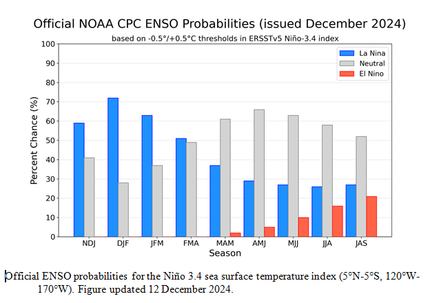
NOAA Updates its Seasonal Outlook on December 19, 2024 – Emerging Weak, Short La Nina Conditions – Posted on December 20, 2024

On the third Thursday of the month right on schedule NOAA issued their updated Seasonal Outlook which I describe as their Four-Season Outlook because it extends a bit more than one year into the future. The information released also included the Mid-Month Outlook for the following month plus the weather and drought outlook for the next three months.  I present the information issued by NOAA and try to add context to it. It is quite a challenge for NOAA to address the subsequent month, the subsequent three-month period as well as the twelve successive three-month periods for a year or a bit more.

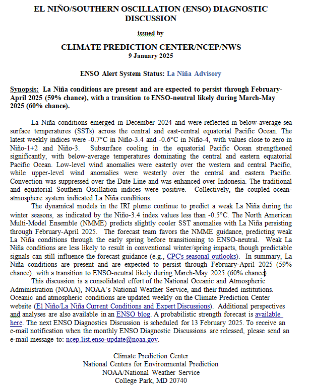
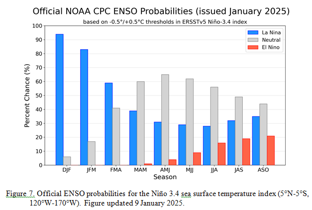
With respect to the long-term part of the Outlook which I call the Four-Season Outlook, the timing of the transition from Neutral to LaNina has been challenging to predict.  But there is more confidence in the situation for the moment. We are still in ENSO Neutral. La Nina is the likely scenario very soon, but the strength of the La Nina may be fairly weak. The transition from ENSO Neutral to La Nina is complicated as is the transition from La Nino back to ENSO Neutral. We may have both of these transitions in the three-month period January through March which is a rapid sequence of transitions. So even if we have La Nina conditions for two or three months this period of time will probably not be recorded as a La Nina event because of the short duration. Every ten years the definition of climate normals are changed (it may be every five years for oceans). Some ENSO events are canceled and others are promoted to El Nino or La Nina status when the definition of climate normals (also called climatology) is updated.  This applies to the ONI status only as they do not reexamine the connection with the atmosphere. The warming of the oceans may very well make our definition of the states of ENSO incorrect. NOAA is looking at that.

From the NOAA discussion:

“El Niño Southern Oscillation (ENSO)-neutral conditions are present, as equatorial sea surface temperatures (SSTs) are near-to-below average in the central and eastern Pacific Ocean. During the last four weeks, mostly negative SST anomaly changes were evident across the equatorial Pacific Ocean. As such, a La Niña Watch is in effect, with La Niña conditions most likely to emerge in November 2024 – January 2025 (NDJ) (59% chance) and is expected to persist through February-April (FMA) 2025. In fact, the latest weekly Nino 3.4 SST departure was -0.6 degrees Celsius, which technically crosses the La Niña threshold. However, chances of a strong La Niña are exceedingly small, with a near zero percent chance of occurrence through the Winter. ENSO-neutral conditions are favored to re-emerge by the March-May (MAM) 2025 season.”

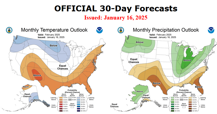
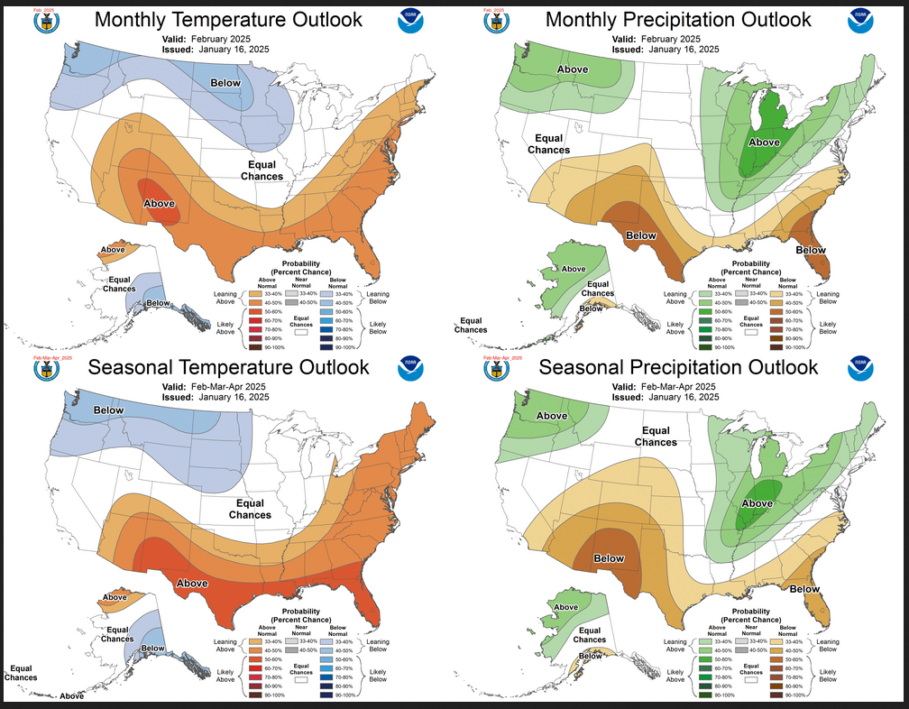
I personally would not have total confidence in this outlook given the uncertainty about there actually being a La Nina and its strength and duration if it does happen.  The number of El Nino and La Nina events since 1950 is a fairly small number. When you further segment them by strength (LINK) you end up with a very small number of events in each category (El Nino v La Nina and three or four categories of strength within each (thus 7 subcategories). This makes both statistical methods and dynamical models have a large error range.  We are pretty confident now that we will have either a weak La Nina or Neutral with a La Nina bias meaning it will be in the Neutral Range but closer to a La Nina than the midpoint of ENSO Neutral. This suggests that there is value in this forecast. The maps show the level of confidence that NOAA (really the NOAA Climate Prediction Center – CPC) has for the outlook shown when they show a part of the U.S. or Alaska differing from normal.

Let’s Take a Look at the (mid-month) Outlook for January.

It will be updated on the last day of November.

Then we look at a graphic that shows both the next month and the next three months.

The top row is what is now called the Mid-Month Outlook for next month which will be updated at the end of this month. There is a temperature map and a precipitation map. The second row is a three-month outlook that includes next month.  I think the outlook maps are self-explanatory. What is important to remember is that they show deviations from the current definition of normal which is the period 1991 through 2020.  So this is not a forecast of the absolute value of temperature or precipitation but the change from what is defined as normal or to use the technical term “climatology”.

Notice that the Outlook for next month and the three-month Outlook are fairly similar except for temperatures in the Northwest and Alaska.  This tells us that February and March will be substantially the same as January for most of CONUS. Part of the explanation for this is that NOAA expects La Nina to impact all three months.

The full NOAA Seasonal Outlook extends through January/February/March of 2026 (yes that is more than a year out). All of these maps are in the body of the article. Large maps are provided for January and the three-month period January/February/March.  Small maps are provided beyond that through January/February/March of 2026 with a link to get larger versions of these maps. NOAA provides a discussion to support the maps. It is included in the body of this article.

In some cases, one will need to click on “read more” to read the full article. For those on my email list where I have sent the url of the article, that will not be necessary.

Weather Outlook for the U.S. for Today Through at Least 22 Days and a Six-Day Forecast for the World: posted December 20, 2024

This article focuses on what we are paying attention to in the next 48 to 72 hours. The article also includes weather maps for longer-term U.S. outlooks (up to four weeks) and a six-day World weather outlook which can be very useful for travelers.

First the NWS Short Range Forecast. The afternoon NWS text update can be found here after about 4 p.m. New York time but it is unlikely to have changed very much from the morning update. The images in this article automatically update.

Short Range Forecast Discussion
NWS Weather Prediction Center College Park MD
Thu Dec 19 2024
Valid 12Z Fri Dec 20 2024 – 12Z Sun Dec 22 2024

…Snow will fall over parts of the Great Lakes, Central Appalachians, and
Northeast…

…Record warmth possible across the West Friday and Saturday,,,

The general flow pattern favors an upper level trough across the eastern
Pacific ocean, ridging aloft in the West, and troughing aloft in the
eastern United States. The consequence of this pattern will be some
rainfall along the West Coast, warmth across the Intermountain West, and
cold across portions of the East. Starting out West, skirmishes of rain
along the West Coast are expected both Friday and Saturday as low pressure
systems move from the eastern Pacific first into Alaska then into western
Canada. By Saturday, the second low moving into western Canada will push
rainfall into the northern Intermountain West, and snowfall at higher
elevations by Saturday afternoon and evening. High temperatures across
northern portions of the West will rise into the 40s and 50s, high enough
to threaten record high temperatures Friday into Saturday. Across the
Southwest, high temperatures should rise into the 70s and 80s, also
threatening record high temperatures in and near southern Arizona.

Mid-continent, a seasonably strong and cold high pressure system migrates
from the Great Plains into the Great Lakes, bringing below average
temperatures near and to its east. For some areas of the East, it should
be the coldest temperatures thus far this winter. When combined with
cyclonic flow around a pair of lows moving through the Midwest and
offshore the East Coast, lake effect and lake enhanced snowfall is
expected near the Ohio Valley, Great Lakes, portions of the Appalachians,
northern Mid-Atlantic States, and New England Friday and Saturday. Winter
weather advisories are in effect for portions of Michigan and the southern
Appalachians to advise further on the snow threat. Across lower
elevations of the Carolinas and southern Mid-Atlantic coast, rain will be
possible on Friday before the lows move out to sea.

To get your local forecast plus active alerts and warnings click HERE and enter your city, state or zip code.

Learn about wave patterns HERE.

Then, looking at the world and of course, the U.S. shows here also. Today we are looking at precipitation.

Please click on “Read More” below to access the full Daily Report issued today.