Updated at 4:06 p.m. December 13, 2022. Thursday afternoon and evening map is now included.
Here is what we are paying attention to Today and the next 48 hours from Tuesday Afternoon’s NWS Forecast. During the week we publish each morning. On Weekends, we will publish late Friday night and do updates during the weekend. Either way, you will have current forecasts with a longer forecast on the weekends. This is a combination of a U.S. plus World Weather Article.
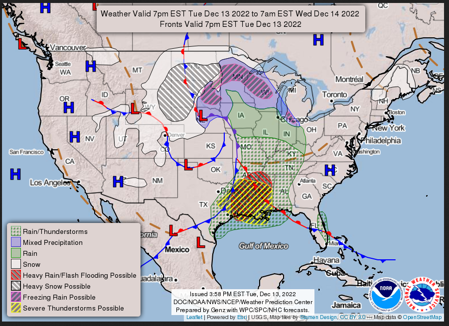
Short Range Forecast Discussion
NWS Weather Prediction Center College Park MD
336 PM EST Tue Dec 13 2022

Valid 00Z Wed Dec 14 2022 - 00Z Fri Dec 16 2022

...There is an Enhanced Risk of severe thunderstorms and a Slight to
Moderate Risk of excessive rainfall over the Lower Mississippi
Valley/Central Gulf Coast through Thursday...

...Heavy snow over the Upper Midwest on Wednesday and over parts of the
Lower Great Lakes, Central Appalachians, and the northern Mid-Atlantic on
Thursday...

...Rain/freezing rain over parts of the Upper Midwest on Wednesday and
Mid-Atlantic/Central Appalachians on Thursday...
Continuation of the NWS Short Range Forecast (It is updated by NWS twice a day and these updates can be found here. We post at least one of those updates daily, sometimes both.
A deep storm over the Central Plains will move northeastward to the Upper
Great Lakes by Thursday evening as a secondary storm develops over parts
of the Mid-Atlantic by Thursday. The impacts from the storm are multiple
days of heavy snow, strong winds, and periods of freezing rain will create
major to extreme impacts across the north-central U.S. from Tuesday into
Thursday evening. Blizzard conditions are expected for the Northern and
Central High Plains, where 1-2 inches per hour snow rates and winds
gusting 50-60 mph will create near zero visibility and snow-covered roads.
Difficult to impossible travel, scattered power outages, and harsh
livestock conditions are expected. Heavy snow and gusty winds will likely
spread across the Northern Plains into the Upper Midwest Wednesday and
Thursday. Blowing and drifting snow will create difficult travel due to
low visibility and snow-covered roads.

A wintry mix, including freezing rain and sleet, will continue across the
Plains and shift into the Upper Midwest through Wednesday. In some areas,
freezing rain accretions may exceed 0.25 inches, creating dangerous travel
conditions and isolated power outages. Strong winds and cold temperatures
will continue even after this storm ends, creating bitterly cold wind
chills. In addition, as the secondary storm develops over the Southern
Appalachians and moves to Mid-Atlantic on Thursday, heavy snow will
develop over parts of the Lower Great Lakes, Central Appalachians, and the
northern Mid-Atlantic. Furthermore, rain/freezing rain will develop over
parts of the region with ice accumulation of up to 0.25 inches.

Meanwhile, as the associated front moves across the Middle/Lower
Mississippi Valley, showers and severe thunderstorms will develop over the
Lower Mississippi Valley. Therefore, the SPC has issued an Enhanced Risk
of severe thunderstorms over the Lower Mississippi Valley through
Wednesday morning. The hazards associated with these thunderstorms are
frequent lightning, severe thunderstorm wind gusts, hail, and a few
tornadoes. In addition, there is an increased risk of EF2- EF5 tornados
over parts of the region.

Moreover, the heavy rain associated with the thunderstorms will produce
excessive rainfall over parts of the Lower Mississippi Valley. Therefore,
the WPC has issued a Slight Risk of excessive rainfall for parts of the
Lower Mississippi and Tennessee Valleys through Wednesday morning. The
associated heavy rain will create mainly localized areas of flash
flooding, with urban areas, roads, and small streams the most vulnerable.

The threat of severe thunderstorms and excessive rainfall continues on
Wednesday as the front moves eastward. Therefore, the SPC has issued an
Enhanced Risk of severe thunderstorms over the Lower Mississippi
Valley/Central Gulf Coast for Wednesday into Thursday morning. The hazards
associated with these thunderstorms are frequent lightning, severe
thunderstorm wind gusts, hail, and a few tornadoes. In addition, there is
an increased risk of EF2- EF5 tornados over parts of the region.

The threat of excessive rainfall increased on Wednesday with the heavy
rain. Therefore, the WPC has issued a Moderate Risk of excessive rainfall
with these thunderstorms over parts of Lower Mississippi Valley, Central
Gulf Coast, and the Southeast for Wednesday into Thursday morning. The
associated heavy rain will create numerous areas of flash flooding.
Furthermore, many streams may flood, potentially affecting larger rivers.

However, the threat of severe thunderstorms and excessive rainfall
decreases on Thursday. Therefore, the SPC has issued a Slight Risk of
severe thunderstorms over parts of the Southeast on Thursday. The hazards
associated with these thunderstorms are frequent lightning, severe
thunderstorm wind gusts, hail, and a few tornadoes.

The excessive rainfall threat ends on Thursday for now. Still, heavy rain
may occur over parts of the Mid-Atlantic near the coast. Also, snow will
linger on Thursday over parts of the Northern/Central Rockies.
Day 1 and Day 2 Maps can be found by clicking Here for Day 1 and Here for Day 2. This Link works also.
Tuesday Evening and Overnight
Wednesday

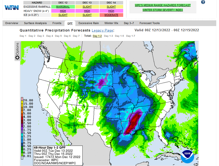
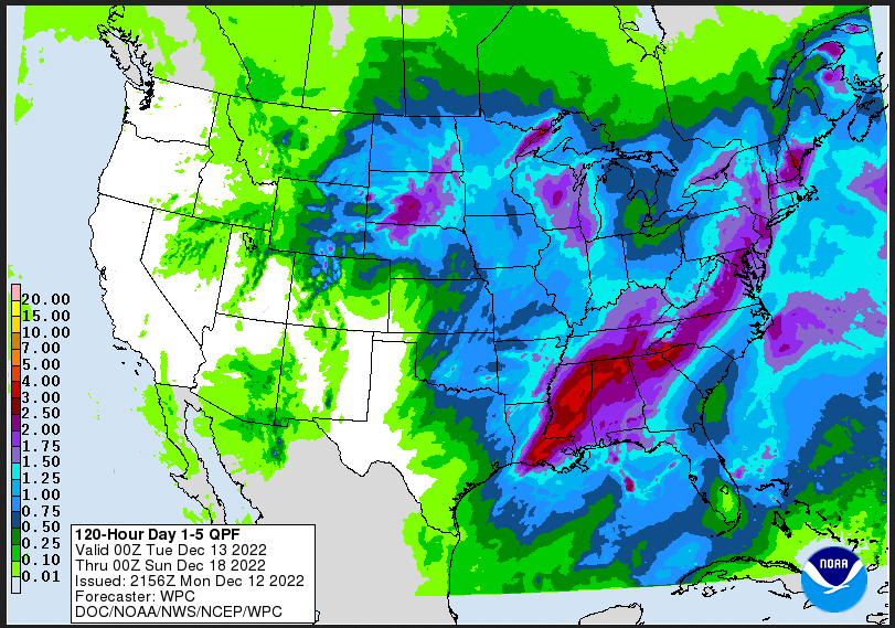
Current Two-day forecast of heavy precipitation (Updates can be found HERE)
Here is a 60-hour animated forecast map that shows how the short-term forecast is expected to play out
If it needs to be updated click here.
ATMOSPHERIC RIVERS
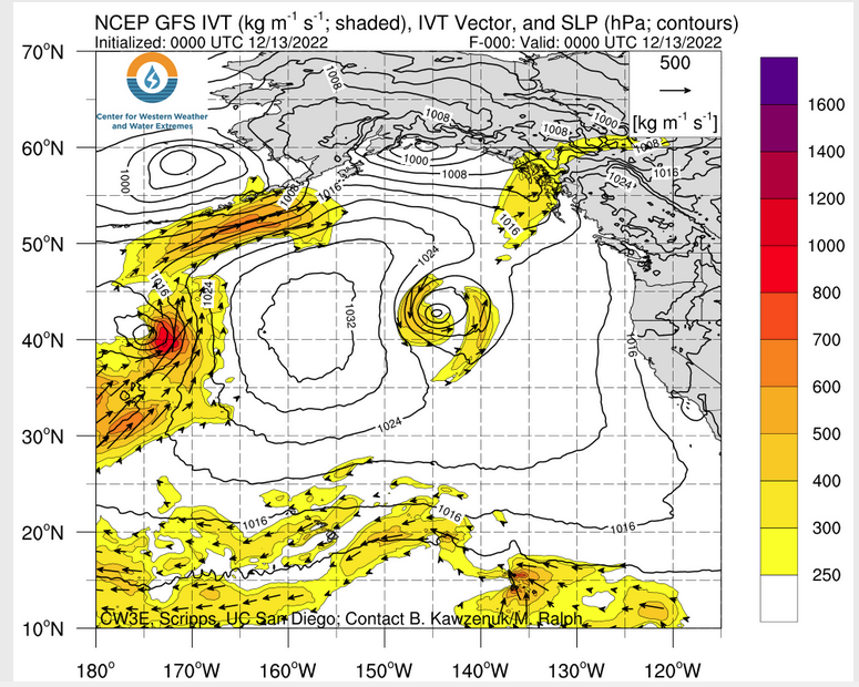
Click HERE to update. Here is some useful information about Atmospheric Rivers.
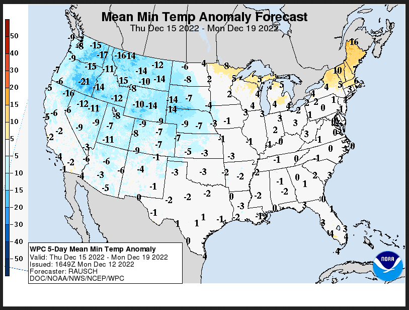
Days 1 Through 5 and 6 – 10 (I update these graphics every two days – but the reader can get an update if they want but the situation usually does not change that quickly)
| Days 1 – 5 (3 – 7 for Temperature) | Days 6 – 10 |
| https://www.wpc.ncep.noaa.gov/medr/medr_mean.shtml | https://www.cpc.ncep.noaa.gov/products/predictions/610day/ |
| These graphics update and can be clicked on to enlarge. You can see where the weather will be. An alternate website is https://www.wpc.ncep.noaa.gov/qpf/day1-7.shtml | |
–
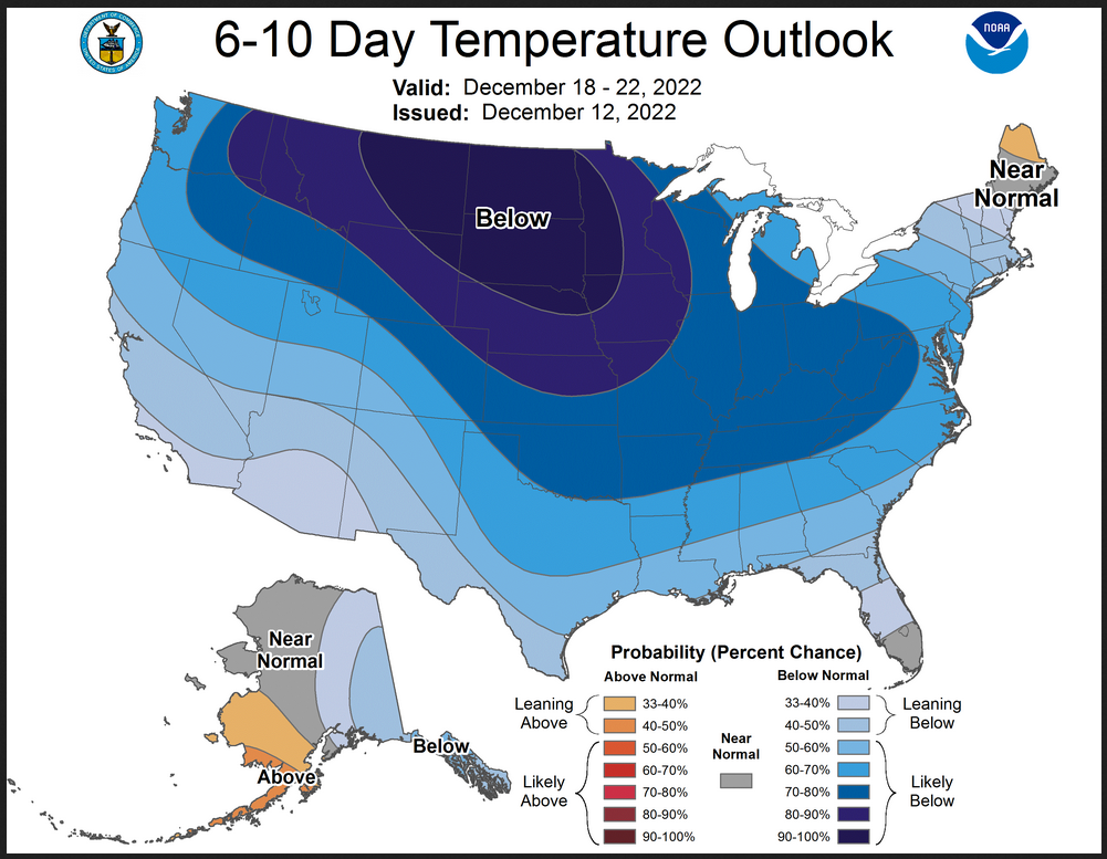
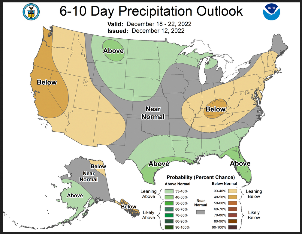
Days 6 – 10 Outlook
An outlook differs from a forecast based on how NOAA uses these terms in that an “outlook” presents information from deviation from normal and the likelihood of these deviations.
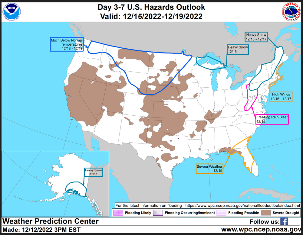
HAZARDS OUTLOOKS (I update these graphics every two days – but the reader can get an update if they want but the situation usually does not change that quickly)
Click h ere for the latest complete Day 3 -7 Hazards forecast which updates only on weekdays. Once a week probably Monday or Tuesday I will update the images. I provided the link for readers to get daily updates on weekdays. Use your own judgment to decide if you need to update these images.
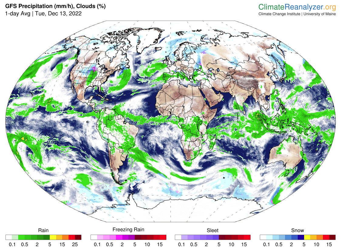
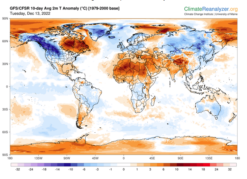
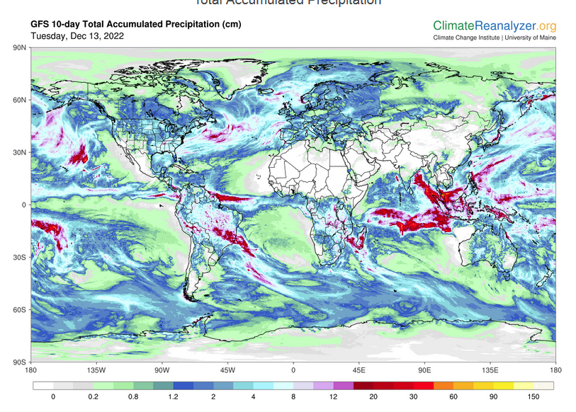
Worldwide Weather (The U.S. is part of the World so the U.S. forecast is included in these maps)
Below maps are the short-term forecast for precipitation and 10-day forecast for temperature and precipitation. I update the Day 1 Forecast daily and the ten-day forecasts every two days. A ten-day forecast is not likely to change much in 24 hours. But if you are looking at an out-of-date version of this article the current forecast maps can be obtained HERE.
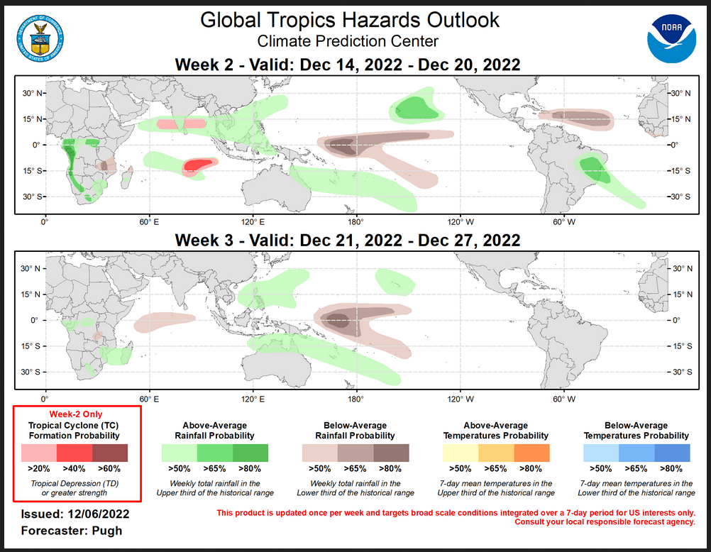
 Worldwide Tropical Forecast
(This graphic updates on Tuesdays) If it has not been updated, you can get the update by clicking here This is a new approach and covers weeks 2 and 3 not weeks 1 and 2. It has more information but I am having trouble getting used to it. As usual, it comes with a discussion which is below
Detailed Maps and Reports for the Western Atlantic and the Pacific Oceans
Below are four maps that summarize the situation for the Atlantic, Eastern, Central Pacific, and Western Pacific. Additional information can be accessed by clicking HERE
First the Atlantic
Click to view the forecast map and have access to additional information https://www.nhc .noaa.gov/gtwo.php?basin= atlc&fdays=5
Then Eastern Pacific
Click to view the forecast map and have access to additional information https://www.nhc.noaa.gov/gtwo.php?basin=epac&fdays=5
Then Central Pacific
Click to view the forecast map and have access to additional information https://www.nhc.noaa.gov/gtwo.php?basin=cpac&fdays=5
And the Western Pacific
Click to view the forecast map and have access to additional information https://www.metoc.navy.mil/jtwc/jtwc.html
Some Longer U.S. Intermediate-Term Outlooks
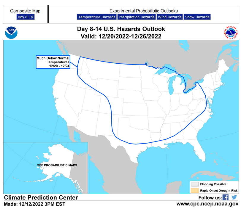
Links to “Outlook” maps and discussions for Two time periods. Days 8 – 14, and Weeks 3 and 4.
You have to click on the links because they do not update automatically and I do not want to have stale images in the article. But it is not difficult to click on a link and you get a large image plus a discussion. On Fridays in a separate article, we will show the images and provide a link in this article that article. But remember what you will see is the images as of Friday. But here you can get the current images simply by clicking on them. Then hit the return arrow at the upper left of your screen to return to the article. You will not find this information easily anywhere else.
| Days 8 – 14 | Weeks 3 and 4 |
| https://www.cpc.ncep.noaa.gov/products/predictions/814day/ | https://www.cpc.ncep.noaa.gov/products/predictions/WK34/ |
| These graphics update and can be clicked on to enlarge. You can see where the weather will e | |
–
Month to Date Information
Month to date Temperature can be found at https://hprcc.unl.edu/products/maps/acis/MonthTDeptUS.png
Month to date Precipitation can be found at https://hprcc.unl.edu/products/maps/acis/MonthPNormUS.png