Updated at 6:05 p.m. December 8, 2022 to include the afternoon NWS 48 hour forecast. We will publish again tonight but also we will also publish the ENSO Update.
Here is what we are paying attention to this afternoon and the next 48 hours from Thursday Afternoon’s NWS Forecast. During the week we will publish each evening. On Weekends, we will publish Friday night and do updates during the weekend. Either way, you will have current forecasts with a longer forecast on the weekends. This is a combination of a U.S. plus World Weather Article.
Short Range Forecast Discussion
NWS Weather Prediction Center College Park MD
309 PM EST Thu Dec 08 2022

Valid 00Z Fri Dec 09 2022 - 00Z Sun Dec 11 2022

...Episodes of moderate to heavy rain expected to track across the
Southern Plains to the Mid-Mississippi Valley the next couple of days...

...Wintry weather spreading into the Central/Northern Plains today and
into the Upper Midwest on Friday...

...Heavy precipitation expected for the Pacific Northwest and northern
California today before significant mountain snowfall arrives tomorrow...
Continuation of the NWS Short Range Forecast (It is updated by NWS twice a day and these updates can be found here. We post at least one of those updates daily, sometimes both.
As has been the story the last few days, a meandering cold front
interacting with an energetic subtropical jet will continue to trigger
episodes of active weather across the south-central portion of the
mainland U.S. A complex of moderate to locally heavy rain persists along
said front this afternoon over the mid-Mississippi/Tennessee Valley,
piling onto the 2-3 inches of rainfall over the region this past week.
Fortunately, no flash flood issues are expected from this activity as the
rainfall is expected to gradually wane in intensity as it migrates toward
the Mid-Atlantic tonight. Behind this moisture stream, low pressure is
forecast to develop along the front and move across the Central Plains
tonight and into Friday with a renewed round of moderate rainfall tracking
through the Mid-Mississippi and Tennessee Valleys tonight into Friday. No
excessive rainfall threat is anticipated from this additional rainfall.

North of the track of the low pressure wave, cold temperatures are
supporting mixed precipitation (including freezing rain and drizzle) and
snow over the Central/Northern Plains, which should reach the Upper
Midwest by Friday morning. A few inches of snow and a glazing of ice is
expected roughly along I-90 over eastern South Dakota through southern
Wisconsin beginning later today. Accordingly, a swath of Winter Weather
Advisories extend through Friday morning over portions of the I-90
corridor. This system is forecast to quickly dissipate on Friday as it
reaches the Great Lakes.  However, another low pressure wave is forecast
to form once again over the Central High Plains Friday night and then
track quickly to the east, bringing another around of moderate to locally
heavy rain to the same general region from the Southern Plains eastward to
the Mid-Mississippi Valley by Saturday morning.

Meanwhile, unsettled weather is in store for the West Coast as a couple of
broad and energetic systems from the Pacific are in the forecast.  Low
elevation rainfall, heavy high elevation snows, and gusty winds from the
first system continue this afternoon  over portions the Pacific Northwest
and California. By tonight, the occluded low pressure is forecast to
weaken as it spreads into the Great Basin. However, remnant Eastern
Pacific moisture streaming inland should yield inland mountain snows over
much of the Intermountain Region that spreads east through tomorrow. The
more robust, moisture laden storm system is forecast approach offshore
portions of the Pacific Northwest by tomorrow afternoon/evening, ushering
in another round of heavy low elevation rainfall and mountain snows along
the West Coast through the weekend. Hourly rainfall rates possibly in
excess of 0.5 inches per hour could cause isolated flash flooding issues
over coastal areas of Northern/Central California tomorrow and Saturday,
particularly atop any burn scar areas. In the mountains, significant high
elevation snowfall is looking increasingly likely over the Cascades and
Sierra Nevadas through the weekend. The latest WPC WSSI now highlights
Major to locally Extreme potential winter storm impacts over the Cascades
and Sierra Nevadas this weekend, where several feet of snow could fall
through Sunday. A slew of Winter Storm Warnings and Watches have been
hoisted this afternoon over parts of the Cascades and Sierra Nevadas
through Sunday morning.
Day 1 and Day 2 Maps can be found by clicking Here for Day 1 and Here for Day 2.
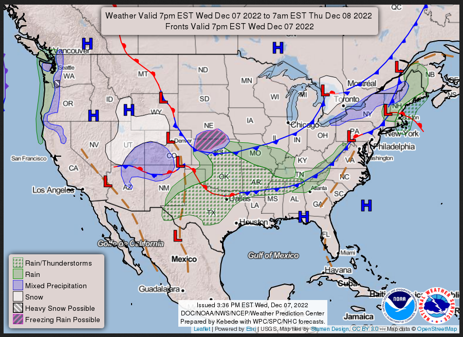
Wednesday Night
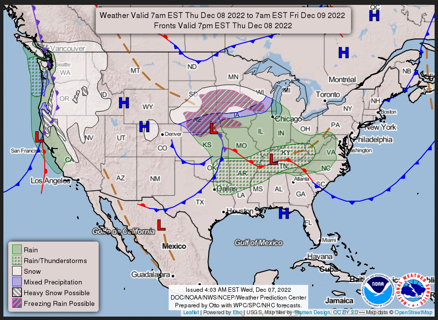
Thursday
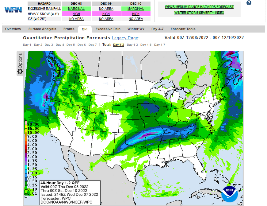
Current Two-day forecast of heavy precipitation (Updates can be found HERE)
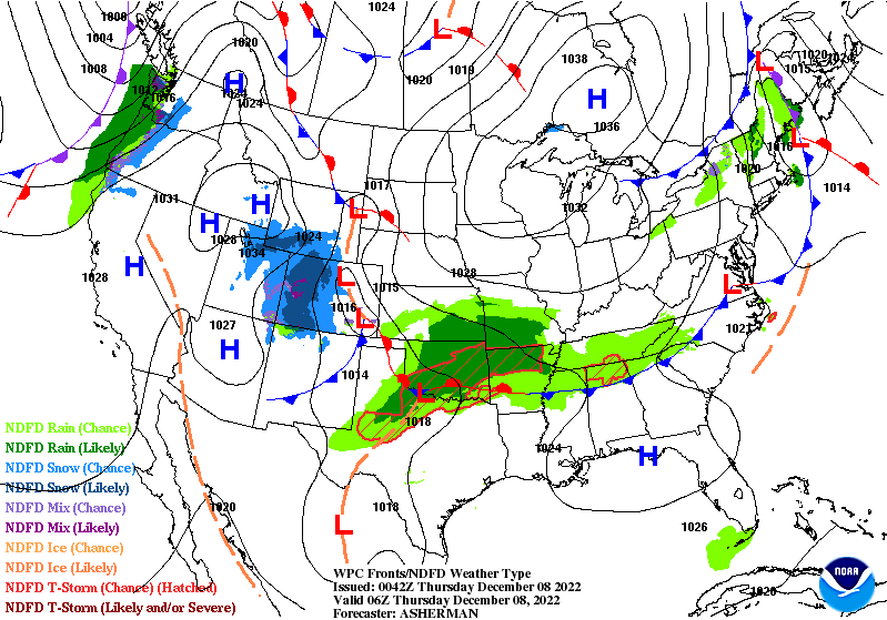
Here is a 60-hour animated forecast map that shows how the short-term forecast is expected to play out
If it needs to be updated click here.
ATMOSPHERIC RIVERS
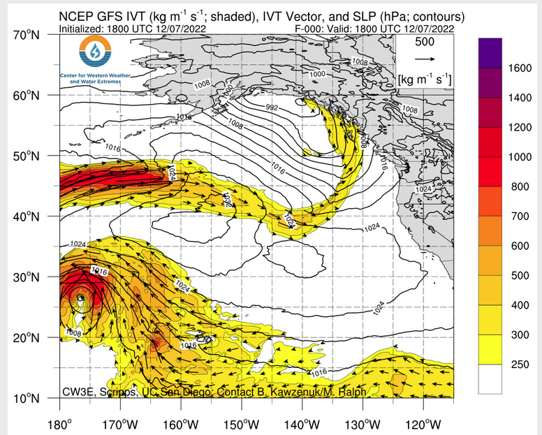
Click HERE to update. Here is some useful information about Atmospheric Rivers.
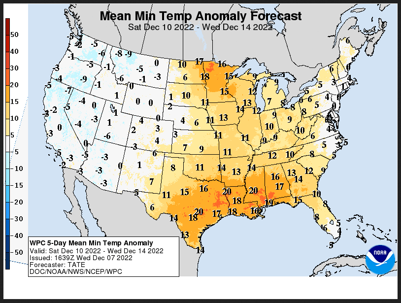
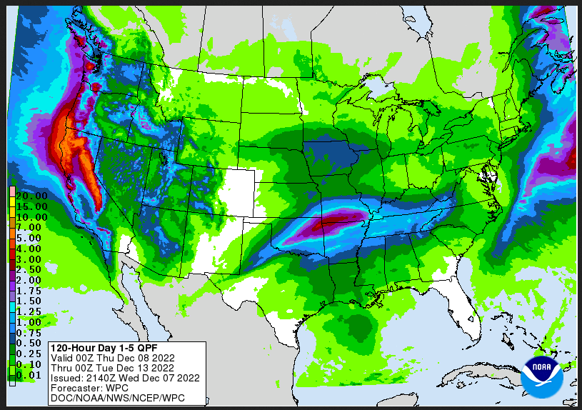
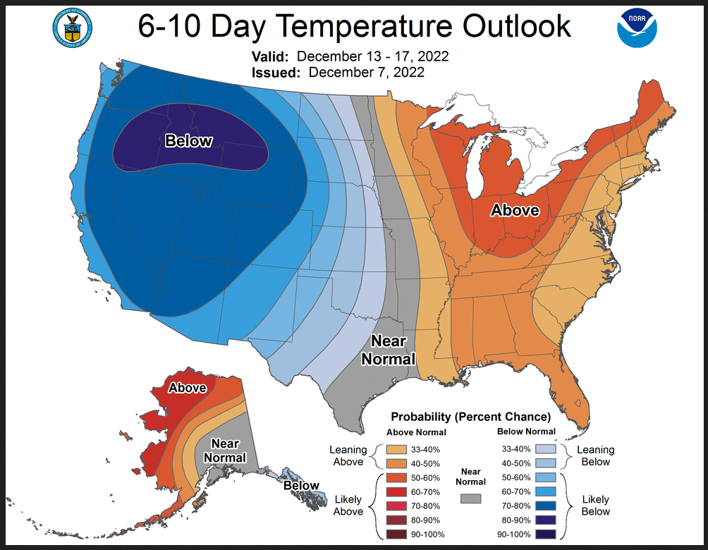
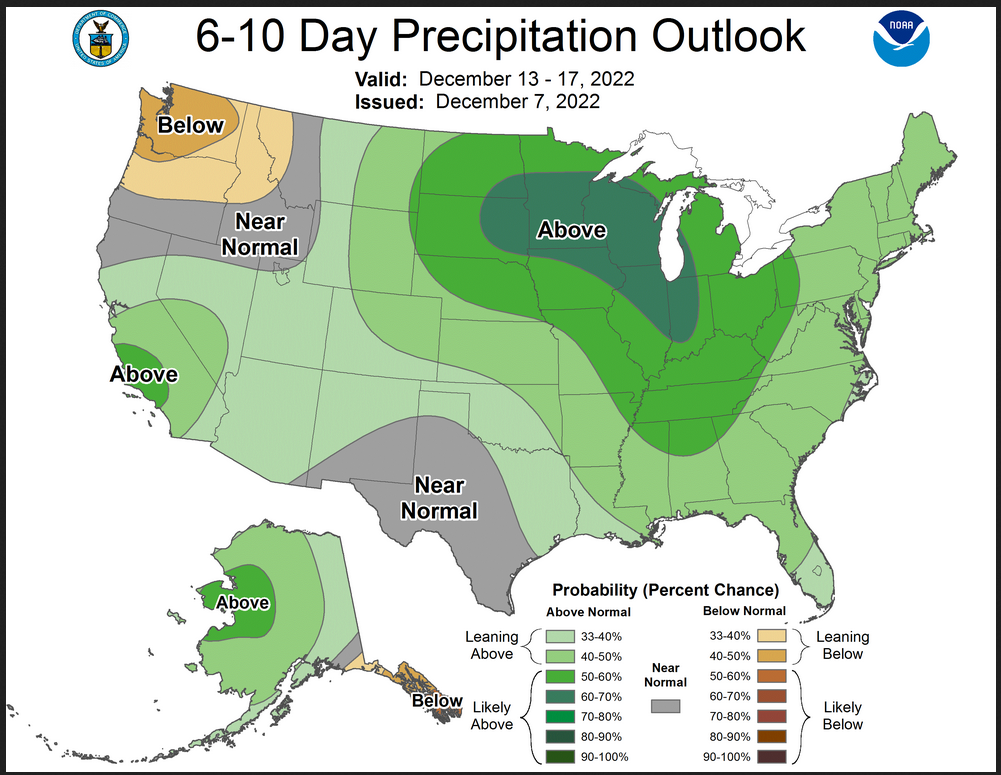
Days 1 Through 5 and 6 – 10 (I update these graphics every two days – but the reader can get an update if they want but the situation usually does not change that quickly)
| Days 1 – 5 | Days 6 – 10 |
| https://www.wpc.ncep.noaa.gov/medr/medr_mean.shtml | https://www.cpc.ncep.noaa.gov/products/predictions/610day/ |
| These graphics update and can be clicked on to enlarge. You can see where the weather will be. An alternate website is https://www.wpc.ncep.noaa.gov/qpf/day1-7.shtml | |
–
Days 6 – 10 Outlook
An outlook differs from a forecast based on how NOAA uses these terms in that an “outlook” presents information from deviation from normal and the likelihood of these deviations.
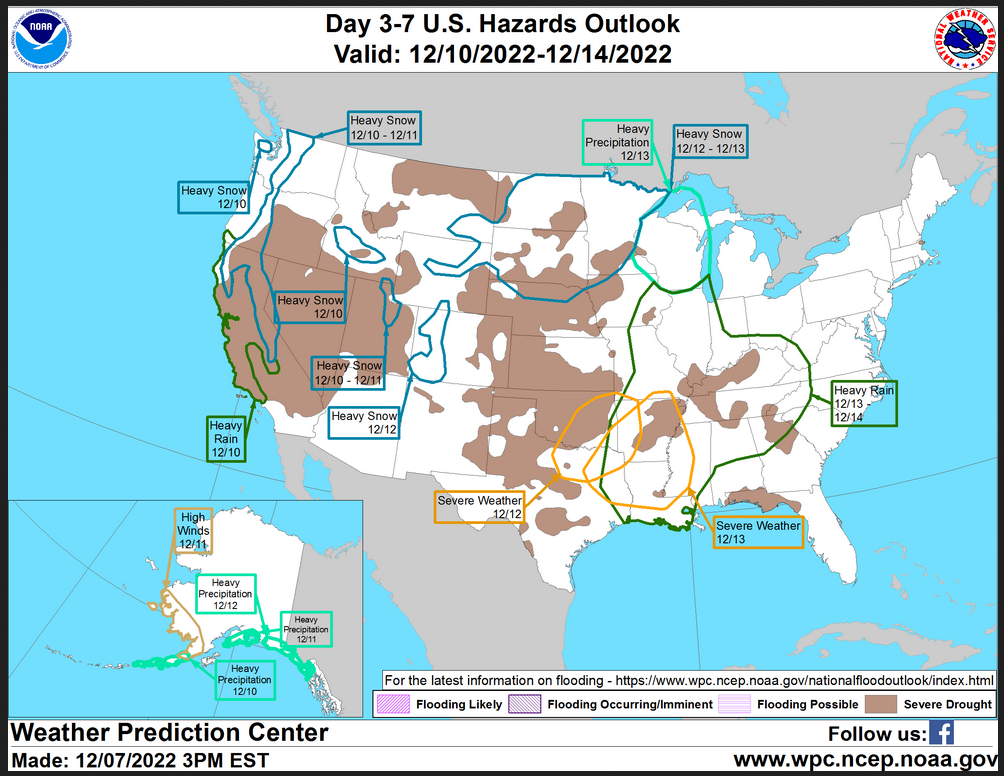
HAZARDS OUTLOOKS (I update these graphics every two days – but the reader can get an update if they want but the situation usually does not change that quickly)
Click here for the latest complete Day 3 -7 Hazards forecast which updates only on weekdays. Once a week probably Monday or Tuesday I will update the images. I provided the link for readers to get daily updates on weekdays. Use your own judgment to decide if you need to update these images.
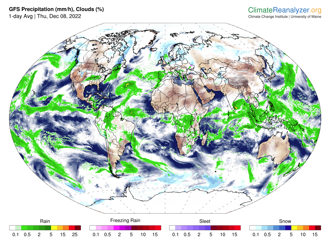
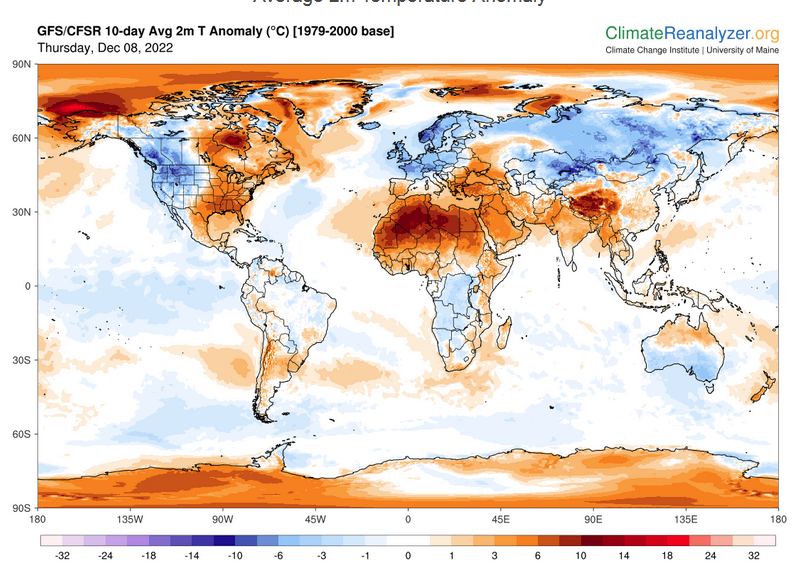
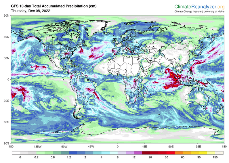
Worldwide Weather (The U.S. is part of the World so the U.S. forecast is included in these maps)
Below maps are the short-term forecast for precipitation and 10-day forecast for temperature and precipitation. I update the Day 1 Forecast daily and the ten-day forecasts every two days. A ten-day forecast is not likely to change much in 24 hours. But if you are looking at an out-of-date version of this article the current forecast maps can be obtained H ERE.
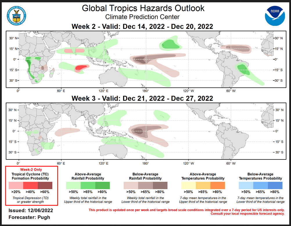
Worldwide Tropical Forecast
(This graphic updates on Tuesdays) If it has not been updated, you can get the update by clicking here This is a new approach and covers weeks 2 and 3 not weeks 1 and 2. It has more information but I am having trouble getting used to it. As usual, it comes with a discussion which is below
Detailed Maps and Reports for the Western Atlantic and the Pacific Oceans
Below are four maps that summarize the situation for the Atlantic, Eastern, Central Pacific, and Western Pacific. Additional information can be accessed by clicking HERE
First the Atlantic
Click to view the forecast map and have access to additional information https://www.nhc .noaa.gov/gtwo.php?basin= atlc&fdays=5
Then Eastern Pacific
Click to view the forecast map and have access to additional information https://www.nhc.noaa.gov/gtwo.php?basin=epac&fdays=5
Then Central Pacific
Click to view the forecast map and have access to additional information https://www.nhc.noaa.gov/gtwo.php?basin=cpac&fdays=5
And the Western Pacific
Click to view the forecast map and have access to additional information https://www.metoc.navy.mil/jtwc/jtwc.html
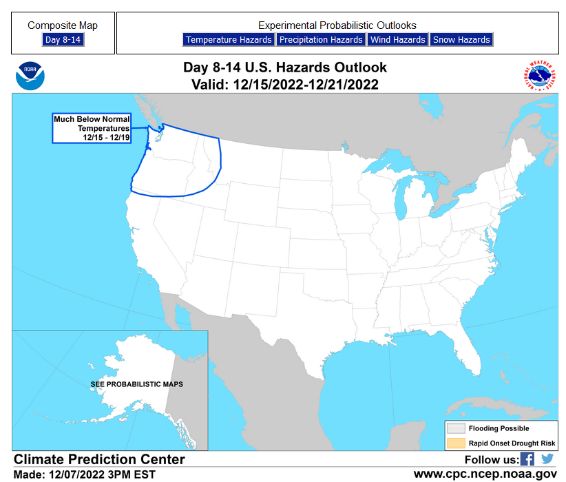
Some Longer U.S. Intermediate-Term Outlooks
Links to “Outlook” maps and discussions for Two time periods. Days 8 – 14, and Weeks 3 and 4.
You have to click on the links because they do not update automatically and I do not want to have stale images in the article. But it is not difficult to click on a link and you get a large image plus a discussion. On Fridays in a separate article, we will show the images and provide a link in this article that article. But remember what you will see is the images as of Friday. But here you can get the current images simply by clicking on them. Then hit the return arrow at the upper left of your screen to return to the article. You will not find this information easily anywhere else.
| Days 8 – 14 | Weeks 3 and 4 |
| https://www.cpc.ncep.noaa.gov/products/predictions/814day/ | https://www.cpc.ncep.noaa.gov/products/predictions/WK34/ |
| These graphics update and can be clicked on to enlarge. You can see where the weather will be | |
–
Month to Date Information
Month to date Temperature can be found at https://hprcc.unl.edu/products/maps/acis/MonthTDeptUS.png
Month to date Precipitation can be found at https://hprcc.unl.edu/products/maps/acis/MonthPNormUS.png