Here is what we are paying attention to this evening and the next two days from this afternoon’s NWS Forecast.
...Dangerous heat and humidity continues across parts of the southern
Plains to the lower Mississippi and Tennessee Valleys through Monday...

...Areas of heavy rainfall over parts of the Mid-Atlantic expected to push
southward into the Southeast on Sunday...

...Severe thunderstorms possible tonight and Sunday over parts of the
northern Rockies to northern Plains, as well as  parts of the Deep South
tonight...
Continuation of the NWS Short Range Forecast (It is updated twice a day and these updates can be found here.
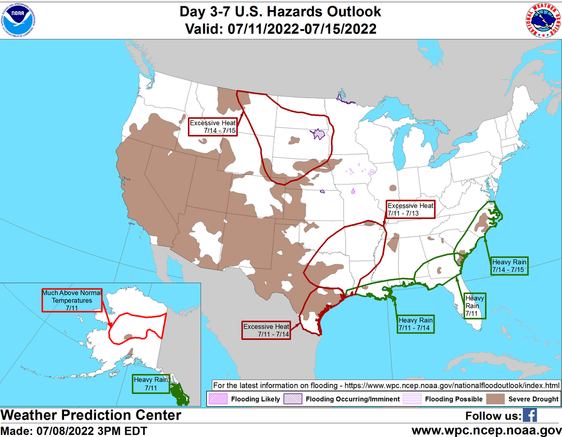
Under the influence of a persistent upper-level high, a heat wave is
forecast to extend through the weekend and into early next week for much
of the mid-South.  In fact, afternoon temperatures are expected to soar
into the upper 90s and well over 100 degrees over Texas through Monday.
Farther east, the effect of high humidity will make the heat more
oppressive over the lower Mississippi Valley even though the temperatures
there are not expected to climb as high.  Heat indices are forecast to
peak above 110 degrees in the above-mentioned areas, where Excessive Heat
Warnings and Heat Advisories continue to be in effect.  Little relief in
the heat is expected during the night either as many locations will have
record high low temperatures.  Slightly cooler air behind a cold front
will work its way down the central Plains during the next couple of days,
making the heat less extreme there.

Meanwhile, tropical moisture lifted behind a wavy front will result in
areas of heavy rain over parts of the Mid-Atlantic through tonight.  The
rainfall threat is forecast to move southward into the Carolinas on
Sunday.  The associated heavy rain will create mainly localized areas of
flash flooding, with urban areas, roads, and small streams the most
vulnerable.  By Monday, the front is forecast to become nearly stationary
just inland from the Gulf Coast and just north of Florida.  The heavy rain
threat is forecast to shift toward the central Gulf Coast with an influx
of tropical moisture.

In the meantime, upper-level energy and weak fronts will aid in
destabilizing the atmosphere over the Northern Rockies to Northern Plains.
Therefore, the SPC has issued a Slight Risk of severe thunderstorms over
parts of Montana into North Dakota and parts of Minnesota through Sunday
morning. The hazards associated with these thunderstorms are frequent
lightning, severe thunderstorm wind gusts, hail, and a few tornadoes.
There will also be an increased risk of severe thunderstorm wind gusts 65
knots or greater and hail two inches or greater over parts of the region.

Furthermore, the severe thunderstorm threat moves eastward over parts of
Minnesota and North/South Dakota on Sunday into Monday morning. Therefore,
the SPC has issued a Slight Risk of severe thunderstorms over parts of the
Upper Mississippi Valley/Northern Plains from Sunday into Monday morning.
The hazards associated with these thunderstorms are frequent lightning,
severe thunderstorm wind gusts, hail, and a few tornadoes.

Moreover, weak monsoonal moisture will trigger diurnal showers and
thunderstorms over parts of the Southwest and Southern Rockies into parts
of the Central Rockies on Saturday into Sunday. In addition, there is an
area of Critical Risk of fire weather over parts of the Great Basin on
Saturday, prompting Red Flag Warnings over the area. The fire weather
threat decreases to an Elevated Risk of fire weather over parts of the
Northern Rockies on Sunday.
21 to 28 Day Forecast/Outlook (On Thursday it is a 22 day forecast and when the Week 3 – 4 Forecast Updates on Friday it becomes a 28 day forecast)

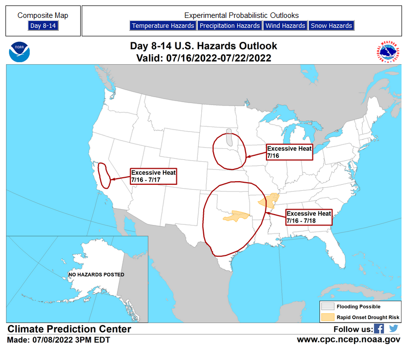
Links to “Outlook” maps and discussions for three time periods. Days 6 – 10, Days 8 – 14, and Weeks 3 and 4. An outlook differs from a forecast based on how NOAA uses these terms in that an “outlook” presents information from deviation from normal and the likelihood of these deviations.
HAZARDS OUTLOOKS
Click here for the latest complete Day 3 -7 Hazards forecast which updates only on weekdays. Once a week probably Monday or Tuesday I will update the images. I provided the link for reads to get daily updates on weekdays. Use your own judgment to decide if you need to update these images.
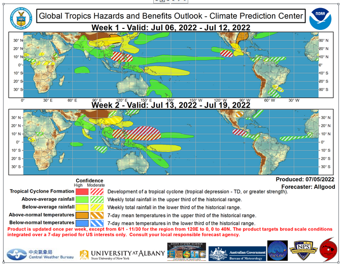
Worldwide Tropical Forecast
(This graphic updates on Tuesdays) If it has not updated you can get the update by clicking here https://www.cpc.ncep.noaa.gov/products/precip/CWlink/ghazards/images/gth_small.png
–
Detailed Maps and Reports for the Western Atlantic and the Pacific Oceans
Below are three maps that summarize the situation for the Atlantic, Eastern and Central Pacific. Additional information can be accessed by clicking HERE
First the Eastern Pacific
Click to view the forecast map and have access to additional information https://www.nhc.noaa.gov/gtwo.php?basin=atlc&fdays=5
Then Eastern Pacific
Click to view the forecast map and have access to additional information https://www.nhc.noaa.gov/gtwo.php?basin=epac&fdays=5
Then Central Pacific
Click to view the forecast map and have access to additional information https://www.nhc.noaa.gov/gtwo.php?basin=cpac&fdays=5
And the Western Pacific
Click to view the forecast map and have access to additional information https://www.metoc.navy.mil/jtwc/jtwc.html
