On the second Thursday of every month, NOAA (really their Climate Prediction Center CPC) issues its analysis of the status of ENSO. This includes determining the Alert System Status. NOAA now describes their conclusion as “ENSO Alert System Status: Final El Nino Advisory/ La Nino Watch”
The exact timing of the transition is now fairly clear which should increase the reliability of the Seasonal Outlook to be issued next Thursday.
We have included an ENSO Blog article by
 >
>
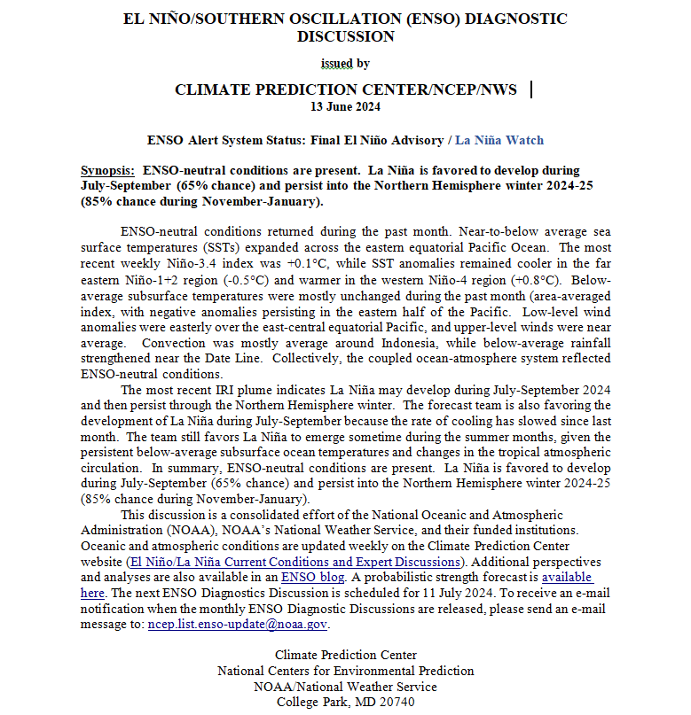
CLIMATE PREDICTION CENTER ENSO DISCUSSION
| The second paragraph is what is important:
“The most recent IRI plume indicates La Niña may develop during July-September 2024 and then persist through the Northern Hemisphere winter. The forecast team is also favoring the development of La Niña during July-September because the rate of cooling has slowed since last month. The team still favors La Niña to emerge sometime during the summer months, given the persistent below-average subsurface ocean temperatures and changes in the tropical atmospheric circulation. In summary, ENSO-neutral conditions are present. La Niña is favored to develop during July-September (65% chance) and persist into the Northern Hemisphere winter 2024-25 (85% chance during November-January; ” Below is the middle paragraph from the discussion last month. “The most recent IRI plume favors an imminent transition to ENSO-neutral, with La Niña developing during July-September 2024 and then persisting through the Northern Hemisphere winter. The forecast team continues to favor the dynamical model guidance, which suggests La Niña could form as early as June-August 2024 [Author’s Note: slipped a month which is not a big surprise], with higher confidence of La Niña during the following seasons. La Niña generally tends to follow strong El Niño events, which also provides added confidence in the model guidance favoring La Niña. In summary, a transition from El Niño to ENSO-neutral is likely in the next month. La Niña may develop in June-August (49% chance) or July-September (69% chance).” |
We now provide additional details.
CPC Probability Distribution
Here are the new forecast probabilities. The probabilities are for three-month periods e.g. MAM stands for March/April/May.
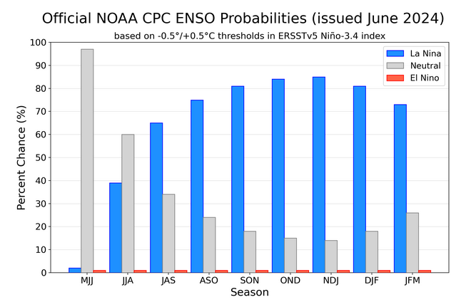
Here is the current release of the probabilities:
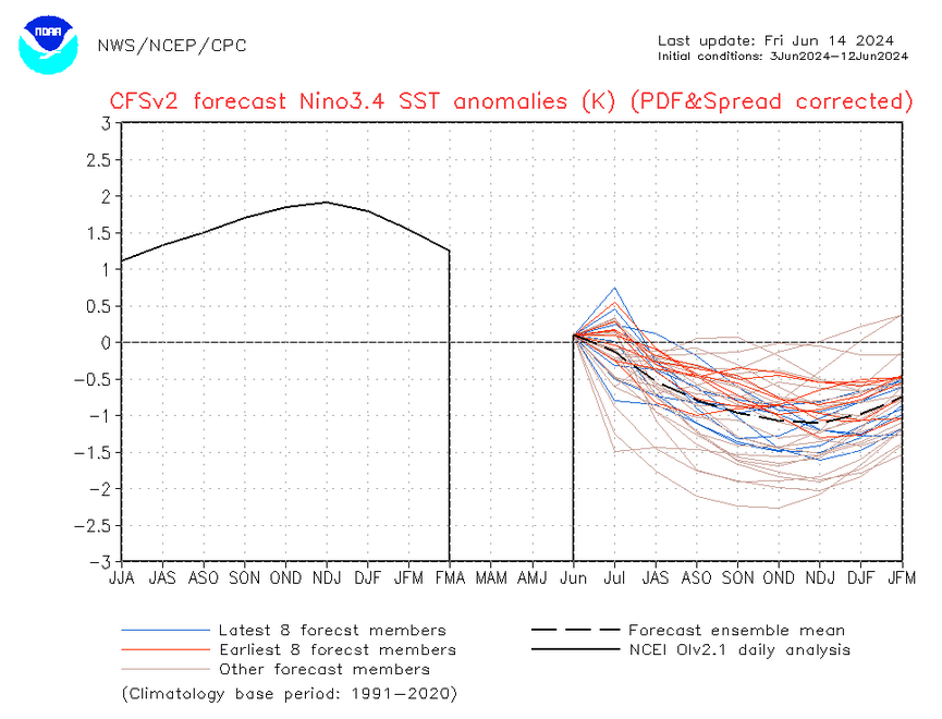
| This chart shows the forecasted progression of the evolution of ENSO from the current El Nino State to Neutral and by the summer to La Nina. This kind of bar chart is not very good at showing uncertainty. |
Here is the forecast from last month.
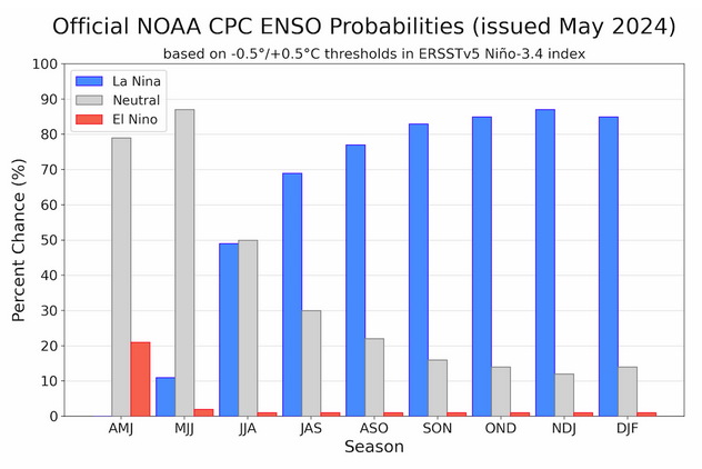
| The analysis this month and last month are a bit different with again the transition to La Nina being slower than thought last month. |
Some will need to click on “Read More” to read the rest of this article.
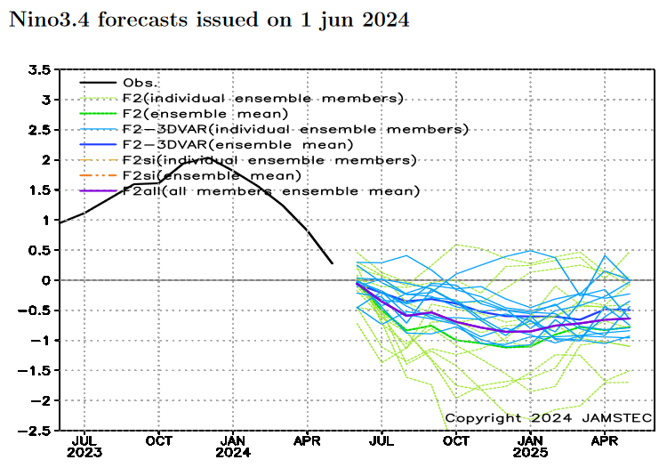
What Does the NOAA Proprietary ENSO Model Forecast?
| Notice the wide spread of the solutions. If you want to see an updated version you can view an updated version by clicking HERE. This is not the official CPC forecast but a secondary tool that they use. It shows a fairly modest La Nina coming. |
View of other Models.
| There is disagreement on this La Nina and the disagreement is geographically oriented. The Asian forecasters are less convinced of a La Nina coming as soon as NOAA predicts. |
I have the JAMSTEC forecasts.
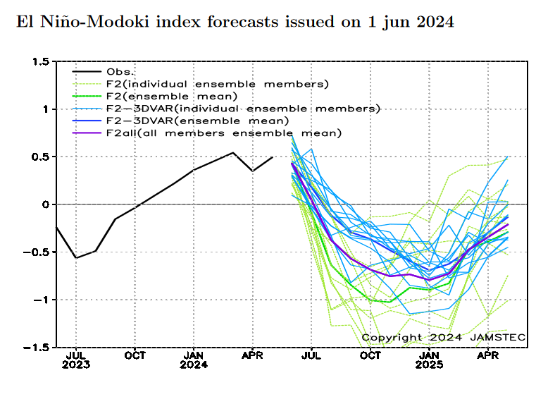
| Both the traditional Nino 3.4 and the Japanese-developed Modoki Index are similar and forecast a fairly weak La Nina. |
Looking at Actual Current Conditions.
NOAA reports some derived data that describes the current situation and a forecast. But what if we want to form our own opinion? After all, meteorologists are looking at the actual current situation and making predictions.
This shows the current actual situation for the surface of oceans. To update this graphic click HERE.

| You can no longer see the warm tongue of water extending from Ecuador and Peru. It has been replaced by a cold tongue. The warm anomaly is increasingly separating from South America and it is not colored very dark red. It has some Modoki characteristics. We are discussing ENSO tonight but you can see a lot of interesting things here. It is only a one-day snapshot so keep that in mind. There is not much warm water along any coast of the United States. The situation for South America and the Western Caribbean is different. |
Putting the historical information in motion. Updates can be found HERE. but should not be needed.

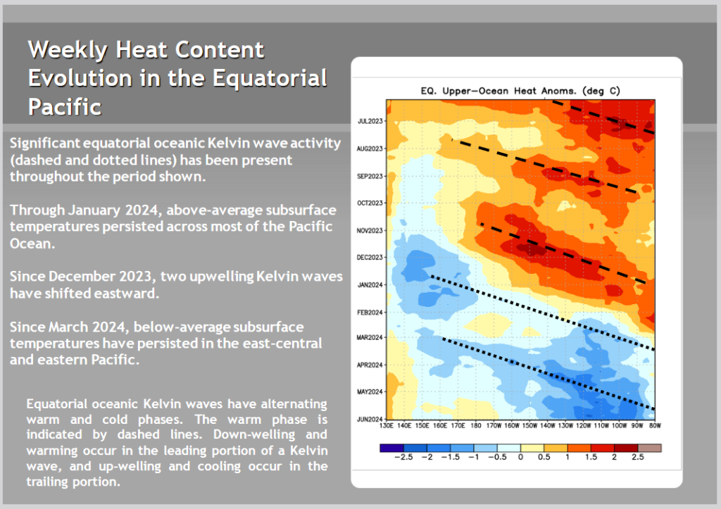
Now we look at the below surface temperature anomalies. Mapping the details. (Cross-Section along the Equator). The data is a five-day average centered on the date shown. There is a larger version of this animation later in this article.
Here is the new map followed by the prior two months to show the progression. The undercutting of the warm water by the cooler water is clear but when does it reach the surface?
![]()

![]()
| I am not sure that this La Nina is developing the way the CPC claims that it is. |
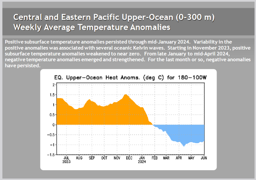
| This shows the water column anomaly is now negative i.e. the warmer water near the surface is dominated by the cooler water below. But the forecast is not for this La Nina to get very intense. |
Kelvin Waves
Are they now predicting a downwelling Kelvin Wave? More skepticism on my part related to the Outlook. |
Is the response of the atmosphere sufficient to sustain an El Nino? This made me want to take a look at the SOI Index, Here is the link to the NOAA version of that graph. They are the same.
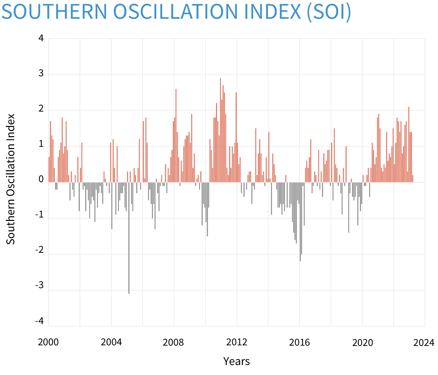
| The SOI is now solidly in ENSO Neutral territory. This is covered in the CPC discussion. |
Now we present the recent ENSO Blog Post by .
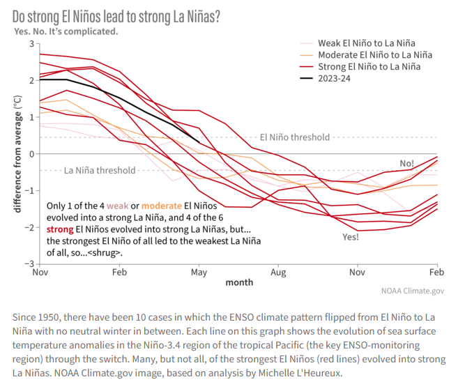
| You may not be able to see the various years as it was pretty faint. Sometime a Strong El Nino is followed by a strong La Nina, but sometimes it is not. |
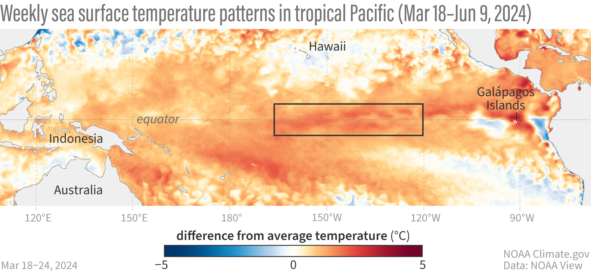
| The above shows the relatively slow change from El Nino to Neutral to La Nina. The above shows the actuals, not the forecasted. |
| I hope you found this article interesting and useful. |