This is not the most informative article on the Polar Vortex but NOAA Climate.gov home of the ENSO Blog that I refer to often has started a Polar Vortex Blog and this is the first blog post. I have provided it in this article but you can also find it HERE.
The post is informative but the Further Reading links in the post are probably even more informative.
Welcome to the Polar Vortex Blog!
We are excited to announce that NOAA Climate.gov, home of the highly popular ENSO Blog, is venturing into a colder, darker, and windier corner of the atmosphere with the new Polar Vortex Blog. We plan to explore various facets of the winds, climate, and chemistry within the fascinating region of the atmosphere known as the polar stratosphere, and explain how this region can sometimes drive big changes in our weather patterns!
While ENSO may be the seasoned celebrity in the seasonal forecasting world, in recent years the stratospheric polar vortex has become a rising star: constantly making headlines and being stalked by the paparazzi, but often misunderstood or misrepresented. We hope to clear up misconceptions, highlight new research, and discuss what the polar vortex is up to and how it may affect our winter’s weather. We expect there to be 1-2 posts per month between December and March, with the initial focus on the Northern Hemisphere polar vortex (yep, there’s one down south, too!).
So who’s on the team?
- Amy Butler is a research scientist at the NOAA Chemical Sciences Laboratory and an expert on the stratosphere and its influence on weather;
- Laura Ciasto is a meteorologist at the NOAA Climate Prediction Center. She leads the development of stratospheric and teleconnection forecast products, but is also a Week 3-4 forecaster (NOAA’s description for forecasts of weather conditions 3-4 weeks in the future);
- The Climate.gov graphics and data visualization team and managing editor, Rebecca Lindsey, with the NOAA Climate Program Office.
While we [Amy & Laura] are the lead editors of the blog, we hope to have guest contributors who can share their own perspectives and research on the polar vortex and related topics. And of course, this blog will not succeed without active engagement from you, our readers. We are happy to hear your constructive feedback and suggestions, and are excited to engage with you on this topic!
After reading this introduction, the first question you might have is likely: What is the polar vortex? And so, that’s where we’ll begin!!
What is the stratospheric polar vortex?
In recent years, most people have heard the phrase “the polar vortex”, which has made regular appearances in media headlines, often with an exciting, albeit sometimes ominous “Day after Tomorrow”, flavor:
- “Get ready: here comes the polar vortex”
- “Northeast U.S. latest to experience polar vortex temperatures”
- “Polar vortex invades central U.S.”
- “Polar vortex breaks record-low temps, snaps steel, empties cities”
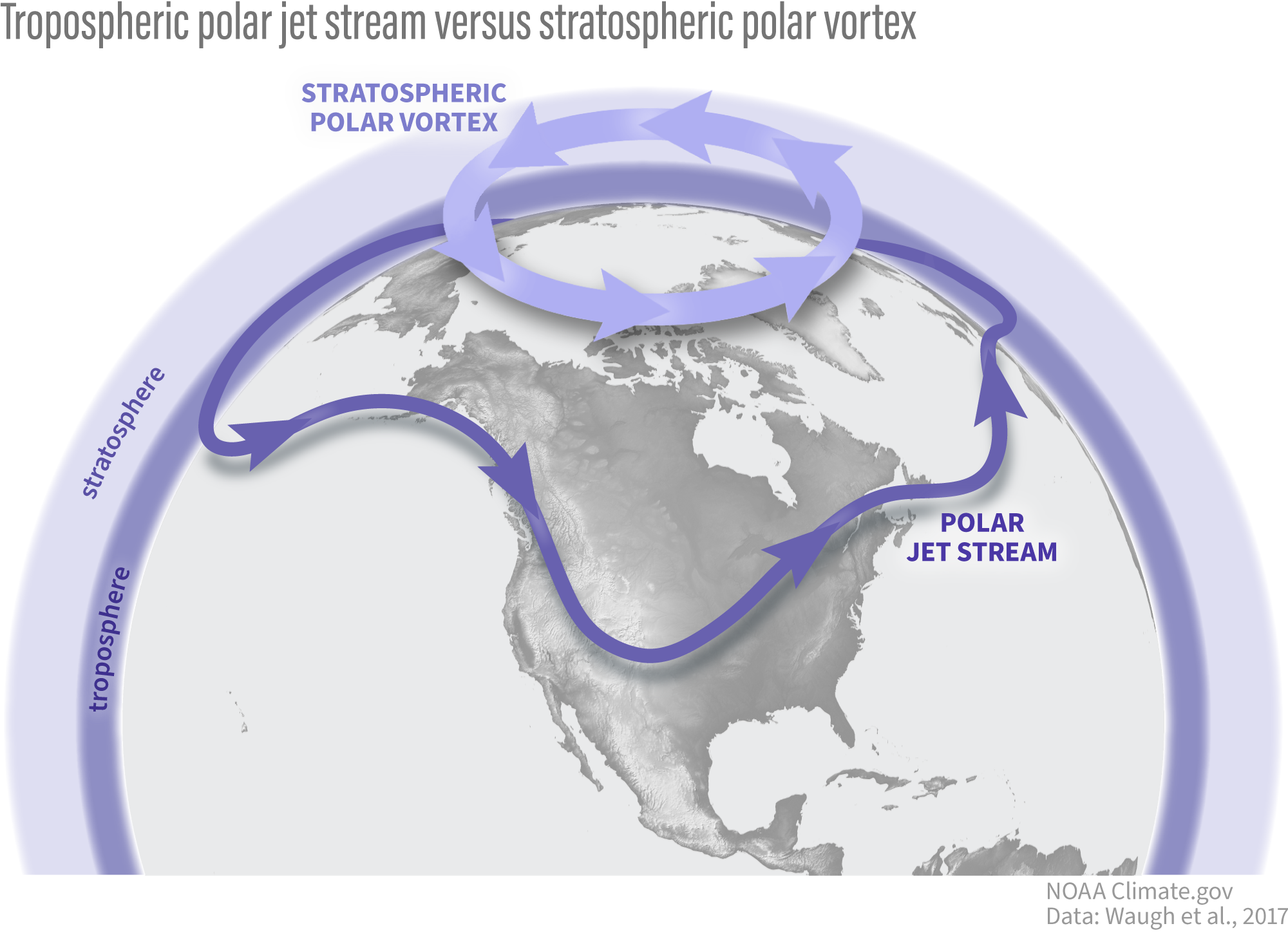
But the “polar vortex” is not actually a synonym for “cold snap”; rather, it’s a well-known feature of Earth’s atmosphere that describes the high-altitude winds that blow around the pole every winter, miles above us in a region called the stratosphere.
The polar vortex is in the polar stratosphere, above the layer of the atmosphere (the troposphere) where most weather, including the jet stream, occurs. NOAA Climate.gov graphic.
The stratospheric polar vortex forms in the winter hemisphere when the Earth’s pole is pointed away from the sun. The polar stratosphere enters darkness and becomes cold relative to the tropical stratosphere [footnote 1]. The temperature contrast makes for strong winds in the stratosphere that blow from west to east. This wintertime stratospheric wind is what we call the Arctic polar vortex [footnote 2].
An atmosphere dance party: who’s the wallflower, and who’s the extrovert?
If we were at a dance party, your first impression might be that the stratospheric polar vortex is the wallflower standing alone on the upstairs balcony, while the tropospheric jet stream is showing off on the dance floor with its flamboyant troughs, ridges, and cut-off lows. But as is so often true, first impressions are not always correct: while the polar vortex often doesn’t mind doing its own thing, it is not a passive watcher of the atmospheric dance down below. With some encouragement, polar vortex can actually become one of the most dynamic dancers there.
Making an impression
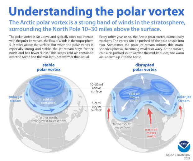
Why does the polar vortex matter to us, given it is so high and far away in the polar atmosphere? That’s one of the things we hope to explore in much more detail on this blog. But one of the main reasons is because the vortex does not always sit quietly by itself. Though it might (literally) need a little push from the troposphere to get its groove on, it can really break down with a move called a “sudden stratospheric warming”.
In this move, the polar vortex may wobble, swing far from its normal position over the pole, or stretch itself way out, sometimes even splitting in two (doing the “splits”? We can hear the groans from here…). And when this happens, the chances of cold weather across many populated regions can increase for many weeks afterwards.
When the Arctic polar vortex is especially strong and stable (left globe), it encourages the polar jet stream, down in the troposphere, to shift northward. The coldest polar air stays in the Arctic. When the vortex weakens, shifts, or splits (right globe), the polar jet stream often becomes extremely wavy, allowing warm air to flood into the Arctic and polar air to sink down into the mid-latitudes. NOAA Climate.gov graphic, adapted from original by NOAA.gov.
Alternatively, sometimes the vortex does another extreme move where it becomes super fast and stable, encouraging the cold air at the surface to stay over the pole, which increases the chances of winter heat extremes in some regions. We will be getting into all the details of these events and their influence on our weather in future blog posts.
Polar vortex groupies
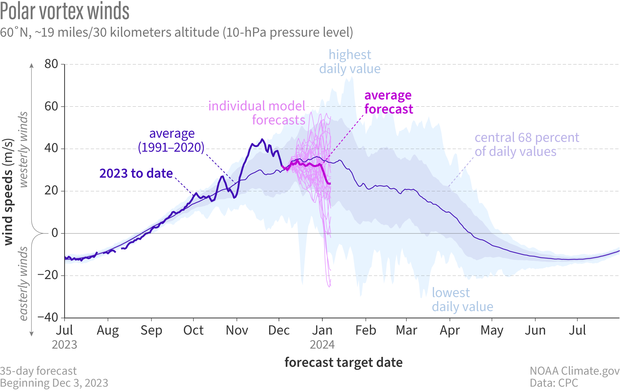
It’s hard to not be fascinated by the strong silent type that suddenly wows you with its awesome dance moves, particularly when those moves can cause extreme weather impacts, so scientists and forecasters have increasingly appreciated the need to monitor what the polar vortex is doing. We usually start by looking at the zonal (east-west) winds at 60N (the latitudes near Anchorage, AK or Oslo, Norway) at around 19 miles (30 kilometers) in altitude, where the air is so thin that the pressure is only 10 millibars (10 hectoPascals). By looking at a time series of these zonal winds we can get an idea of whether the polar vortex is really strong and stable, or weakening and ready to bust into its sudden stratospheric warming moves.
In early December 2023, NOAA’s Global Ensemble Forecasting System (GEFS for short) began hinting that the winds of the Northern Hemisphere polar vortex might be about weaken. The spread of the individual forecasts is still pretty wide (thin pinkish-purple lines), but the average (heavier, bright purple line) predicts that winds will be weaker than average (royal blue line) in December. Climatology of highest and lowest daily values is from Climate Forecast System Reanalysis. NOAA Climate.gov graph, adapted from original by Laura Ciasto.
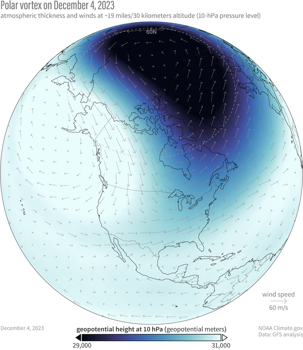
In addition to the strength of the vortex, we often want to know more about its shape. A great way to do this is by simply looking at a map of the thickness of the atmosphere. Throughout the winter, the polar vortex can shift, stretch, or just wobble from its usual spot over the pole, kind of like dancing in place. During strong events or sudden stratospheric warmings, these moves become much more distinct. Seeing the shape shows us which areas are poised to feel the biggest impacts of any unusual polar vortex behavior. There are other cool ways to see what the polar vortex is up to and whether it’s interested in tangoing with the troposphere but we’ll leave that for another post.
The polar vortex on December 4, 2023. Because the air within the polar vortex is generally much colder than the air outside of it, the polar vortex shows up on maps of atmospheric thickness (“geopotential height”) as a region of low thickness. The 10-hectoPascal geopotential height is the altitude at which the pressure is 10 hectoPascals. NOAA Climate.gov image, based on Global Forecasting System (GFS) data from Laura Ciasto.
So what’s the polar vortex doing now? For the last few weeks it’s been embracing its wallflower persona as it sits over the polar region with stronger than average westerly winds. However, it does look like the stratosphere is at least thinking about joining the winter dance. If we look at the average of all the model forecasts from NOAA’s operational forecasting system (known as the Global Ensemble Forecasting System, or GEFS), it predicts that the zonal winds will weaken through the start of the new year.
The real question is whether the polar vortex just wants to dance in place (like it often does) or really show its steps. If we look at the individual forecasts that make up the average, some indicate that those polar vortex westerlies will not only weaken but change direction to blow from east to west [footnote 3], which is how we define a sudden stratospheric warming. In addition, the leading forecast system for Europe (the ECMWF model, short for European Centre for Medium-range Weather Forecasting) shows an even higher likelihood that the vortex will be weaker than normal during December. These hints of a shift towards a weaker polar vortex means we will keep a close eye on whether the polar vortex wants to join an early winter party or sit this one out.
Further Reading
If you can’t wait for the next post to learn more about the polar vortex, our friends at the ENSO blog and at Climate.gov have posted several primers on the polar vortex and some of its most recent disruptions.
- Polar Vortex
- Understanding the Arctic Polar Vortex
- 2021 Sudden Stratospheric Warming
- 2023 Sudden Stratospheric Warming
Other good references on the polar vortex:
- The Stratospheric Polar Vortex and Sudden Stratospheric Warmings
- What Exactly is the Polar Vortex?
- What’s in a Name? On the Use and Significance of the Term “Polar Vortex”
Footnotes
- Now, you might be thinking, “But isn’t the stratosphere always colder at the poles than it is at the equator? No! In the summer, it’s actually warmer. We’ll cover this in a future post.
- Most of our descriptions in this post are talking about the Arctic polar vortex, but there is also an Antarctic polar vortex at 60S. It has some of the same features as its Arctic counterpart, but the Antarctic polar vortex is also unique, often dancing to the beat of a different song. We’ll delve into that more in future posts.
- When the winds blow from west to east, as is typically the case with the stratospheric polar vortex, this is said to be “westerly” flow, and is marked by zonal wind speeds that are positive in sign. When the winds blow from east to west, which is what happens when a sudden stratospheric warming occurs, the flow is instead called “easterly” and is denoted by zonal wind speeds that are negative in sign.

