Recently we have published the NOAA (find it here) and the JAMSTEC (find it here) temperature and precipitation Outlooks. I have been letting my readers compare them but tonight I decided to see if I could make it easier for readers to do that.
So that comparison is in the body of this article. Surprisingly they are fairly similar aided by the forecast of an El Nino. They are by no means identical.
NOAA is predicting a stronger El Nino than predicted by JAMSTEC. This may explain some of the differences. Looking at two different forecasts can help the reader understand the range of possibilities that are possible. Hopefully, readers will find this interesting.

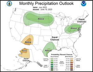
Comparing the NOAA and JAMSTEC temperature and precipitation Outlooks for July and three (somewhat overlapping) three-month periods.
First, we look at the single month of July. On the left is JAMSTEC, and on the right,. is NOAA.
We start with the Temperature Outlooks. We have done our best to have the two outlooks line up in a way they can be compared. The NOAA forecast has Alaska shown under CONUS. We probably could have done that with a significant level of effort. We show all of North America as one can see the weather pattern that way for the JAMSTEC image.
| J
U L Y – 2 0 2 3 |
|
|
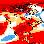

| They are pretty similar |
Then we look at the precipitation. Again the JAMSTEC Outlook is on the left and the NOAA Outlook is on the right.
| J
U L Y – 2 0 2 3 |
|
|
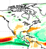
| They are also fairly similar. They both predict a less than robust Southwest Monsoon which shows up as drier than normal. It will be wet but not as wet as usual. The big difference is the location of the wetter than normal areas in the East but if you look closely the difference is not that great. |
Now we look at the three-month Outlooks. JAMSTEC shows JAS, SON, and DJF. Notice the overlap between JAS and SON. We matched their Outlooks with the same three-month periods from the NOAA. Again, the JAMSTEC Outlook is on the left, and NOAA is on the right.
First Temperature
| J
A S – 2 0 2 3 |
|
|
| A
S O – 2 0 2 3 |
|
|
| N
D J – 2 0 2 3 / 2 4 |
|
|
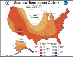
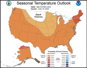
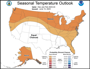
| They are pretty similar. There is a difference in where the EC area (the white area on the maps) is located which has to do with the prediction of how the Jet Stream will approach the West Coast and perhaps a prediction of what is called the PNA. |
Then we look at the precipitation
| J
A S – 2 0 2 3 |
|
|
| A
S O – 2 0 2 3
|
|
|
| N
D J – 2 0 2 3 / 2 4 |
|
|
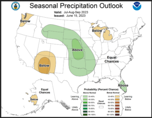
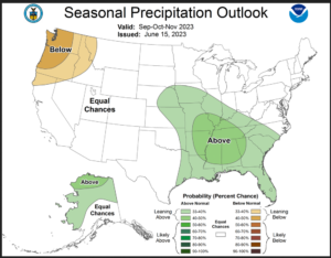
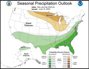
| There is a lot of similarity. They are certainly not identical. But they both show the more southerly storm track associated with El Nino after the summer. They both show a weak Southwest Monsoon. |
| I hope you found this article interesting and useful. |