Updated at 9:40 p.m. EST Saturday, February 4, 2023
Here is what we are paying attention to in the next 48 to 72 hours. This article also includes World weather forecasts.
It also includes links for longer-term outlooks and sometimes (like today) we show the maps that one finds if one clicks on those links. But we can not update all of those maps each day so look at the date and the duration of the period of time involved. If you want a more up-to-date map, click on the provided link which may be located in a table of links. If the date in the title of the article is not today’s date. just go to Econcurrents.com and look for today’s weather article.
We start with the U.S. Information.
Short Range Forecast Discussion
NWS Weather Prediction Center College Park MD
239 PM EST Sat Feb 04 2023Valid 00Z Sun Feb 05 2023 – 00Z Tue Feb 07 2023
…Frontal system moving through the West brings increased chances of
lower elevation/coastal rain and moderate to heavy mountain snow……Rapid warm up Sunday for the Northeast after record-breaking arctic
blast……Unseasonably warm temperatures for the Plains and Midwest with an
Elevated Risk for Fire Weather in the Southern High Plains Sunday…
![]()
–
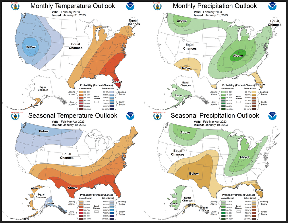
| The groundhogs in many places say six more weeks of winter. What does that mean? Meteorological Winter ends when March begins but Astronomical Winter ends on March 19. So it seems we have some very cagey groundhogs. It probably depends on where you live. For the U.S. we provide links in this daily report that show the outlook out through four Fridays and on Friday we show all the maps to make it easier for readers. And a few days ago we showed the updated outlook for February. I do not remember if we published the JAMSTEC outlook for the World but later today I will add the most recent JAMSTEC forecast for the next three months. The current Outlook for the next three months for the U.S. is included in what we published a few days ago. It was issued on January 19 but is included in the End of Month report which you can access HERE. Have fun with this but we have to wait six weeks to assign a grade to the various groundhogs who provided us with their wisdom. |
Here is the NOAA forecast for February and the three-month period February, March, April
Here is another forecast by another meteorological agency JAMSTEC. It is a forecast for the single month of March. It is a World forecast but you can see the forecast for the U.S. in these two maps: Temperature and Precipitation.
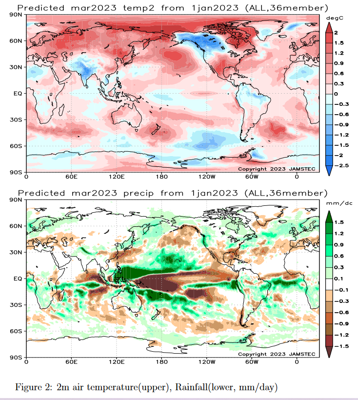
| Overall it looks like professional meteorologists are not agreeing with the groundhog. But it depends on where you live. We will have updated forecasts for March soon. I am showing two forecasts above: one issued a few weeks ago and the JAMSTEC forecast a bit older. In today’s article, we show a forecast through March 3. In a week it will extend through March 10. A week later it will extend through March 17. By then we will have new forecasts for March. I will be keeping readers of my weather articles informed. Stay tuned. |
Now, the 48-Hour Forecast (It is a 48 to 72 Hour Forecast actually)
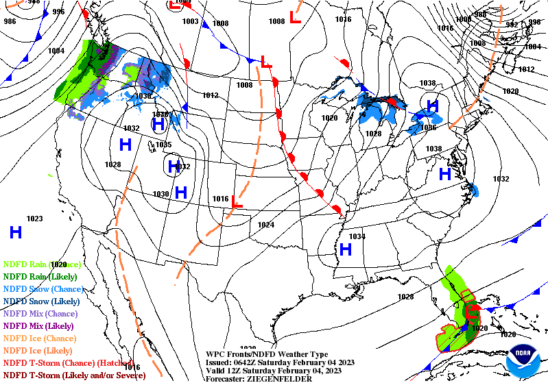
Daily weather maps. I try to keep the below three maps updated. The Day 1 map updates twice a day and the Day 2 and 3 maps update only once a day. I will be doing the updating during the period described in the title of the article but if you happen to read this article later, you can get updates by clicking HERE.
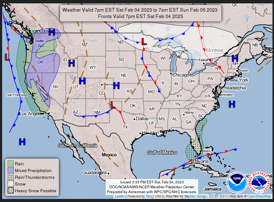
SATURDAY AFTERNOON, EVENING AND OVERNIGHT
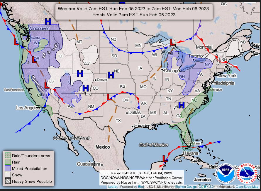
SUNDAY
MONDAY
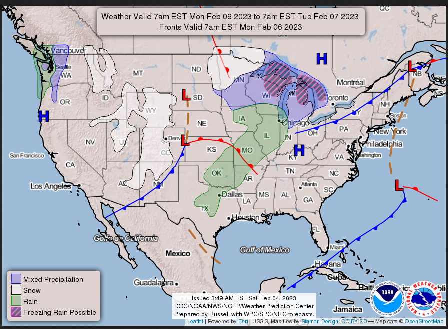
This animation shows how things may play out over the next 60 hours. To update click here.
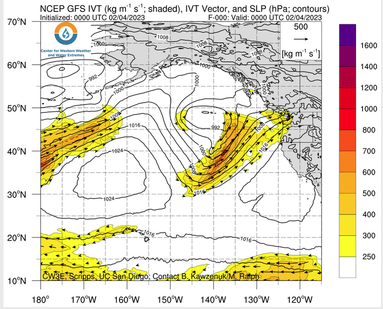
ATMOSPHERIC RIVERS
Continuation of the NWS Short Range Forecast (It is updated by NWS twice a day and these updates can be found here. We post at least one of those updates daily, sometimes both. The Highlights are shown in the lede paragraph of this article.
A deep upper-level trough and associated frontal system over the Pacific
will begin to move eastward over the western U.S. late Saturday. Increased
moisture from the Pacific will lead to the chance for some moderate to
heavy rain along the West Coast Sunday, especially for the northern and
central California coast where rainfall totals of 1-2″ are forecast. This
moisture will spread further inland bringing moderate to heavy snow to the
Cascades, Sierra, and mountain ranges of the northern Great Basin Sunday
before spreading into portions of the northern and central Rockies on
Monday. Snowfall totals will range between 6-12″, with locally higher
amounts of 18″+ possible for some of the higher mountain peaks. Totals
will be even higher in the Sierra, where Winter Storm Warnings are in
effect for 1-3 feet of snow and gusty winds as high as 60 mph. Lower
elevation/valley locations of the Great Basin and northern/central Rockies
will see a mix of rain and snow, with little to no accumulations expected.
High temperatures will cool following the passage of a cold front, with
highs mostly in the 50s to low 60s for the Pacific Northwest and
California on Sunday, and highs in the 30s for the Great Basin and upper
50s to the mid-60s for the Desert Southwest on Monday.Temperatures will rapidly moderate across the Northeast on Sunday after a
couple days of record lows and historicly cold wind chill values. The dip
in the jet stream responsible for sending a surge of arctic air southward
will move east of the area with southerly winds advecting warmer air from
the south northward. Lows will still be rather chilly Sunday morning for
portions of New England, with temperatures around 0, but temperatures will
warm back up above freezing for most locations by the afternoon. Highs
further south in the Mid-Atlantic will be in the 40s to low 50s, with 50s
to low 60s for the Southeast. These seasonably warm temperatures will
continue into Monday, with most of New England also warming up into the
40s. Some light rain showers will be possible along the coast for the
Southeast Sunday and into the Mid-Atlantic Monday. Additionally, some
light snow showers are possible in the Interior Northeast, particularly in
favorable lake-effect areas. A frontal boundary meandering over the
Florida Peninsula will lead to increased chances for showers and
thunderstorms, with heavy rainfall possible along the Atlantic coast late
Sunday and into the day Monday.Ahead of the upper-level trough over the west, a ridge will move over the
center of the country and lead to temperatures 15-25 degrees above normal
across large portions of the Plains and Midwest. Highs will be in the 30s
and 40s for the Northern Plains and Great Lakes Region, the 50s and 60s
for the Central Plains, Ohio Valley, and Lower Mississippi Valley, and
into the 70s for portions of the Southern Plains. Breezy winds between
15-25 mph, with higher gusts, will be prevalent along the High Plains as
lee troughing develops east of the Rockies. These gusty winds along with
the warm temperatures, low relative humidity, and dry vegetation have
prompted an Elevated Risk of Fire Weather from the Storm Prediction Center
Sunday for portions of northeastern New Mexico and the western Oklahoma
and Texas Panhandles.
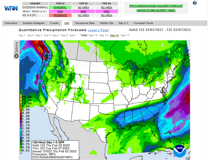
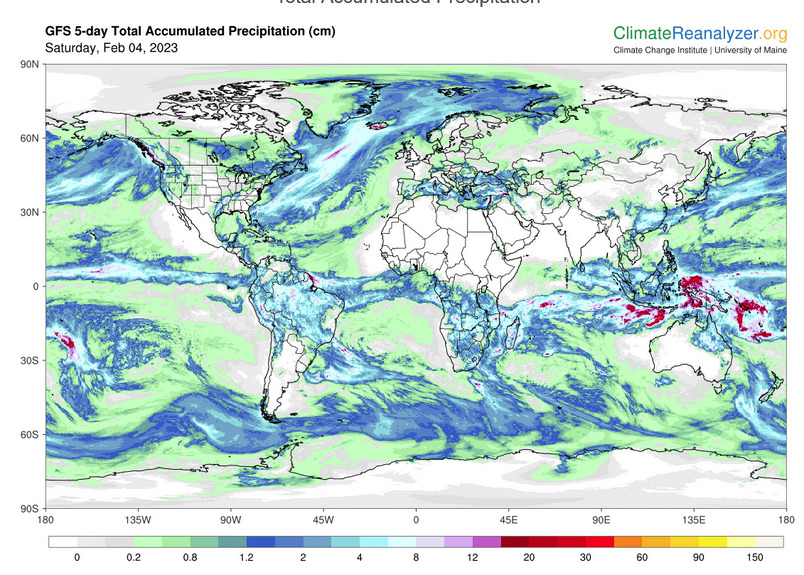
Below is the current five-day cumulative forecast of precipitation (Updates can be found HERE)
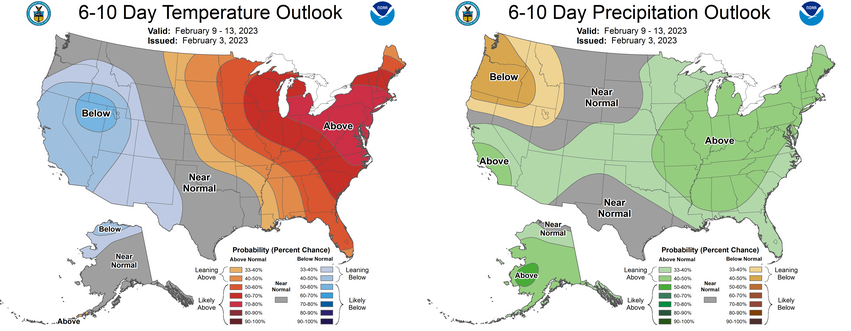
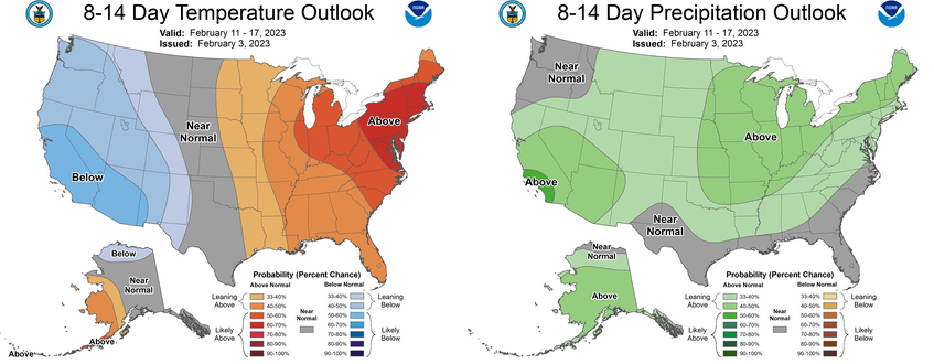
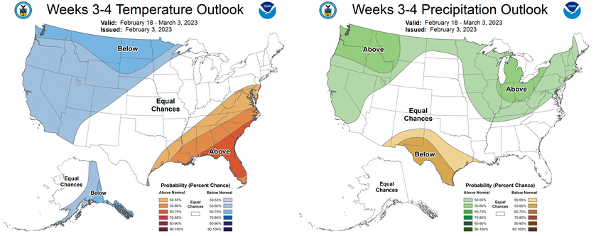
Now we look at Intermediate-Term “Outlook” maps for three time periods. Days 6 – 10, Days 8 – 14, and Weeks 3 and 4. An outlook differs from a forecast based on how NOAA uses these terms in that an “outlook” presents information as deviation from normal and the likelihood of these deviations.
Below are the links to obtain updates and additional information. They are particularly useful if you happen to be reading this article significantly later than when it was published. I always try to provide readers with the source of the information in my articles.
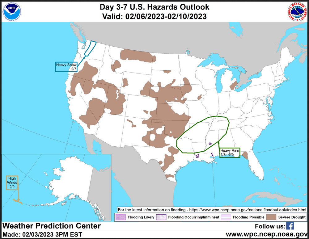
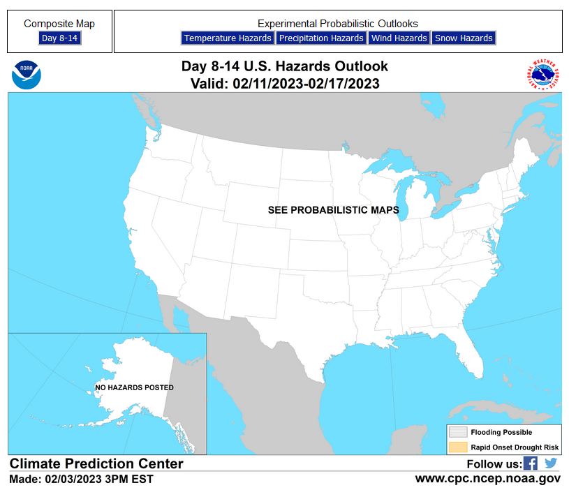
HAZARDS OUTLOOKS
Click here for the latest complete Day 3 -7 Hazards forecast which updates only on weekdays. Once a week probably Monday or Tuesday I will update the images. I provided the link for readers to get daily updates on weekdays. Use your own judgment to decide if you need to update these images. I update almost all the images Friday Night for the weekend edition of this Weather Report. So normally readers do not need to update these images but if the weather is changing quickly you may want to.
Month to Date Information
Temperature month to date can be found at https://hprcc.unl.edu/products/maps/acis/MonthTDeptUS.png
Precipitation month to date can be found at https://hprcc.unl.edu/products/maps/acis /MonthPNormUS.png
World Forecast
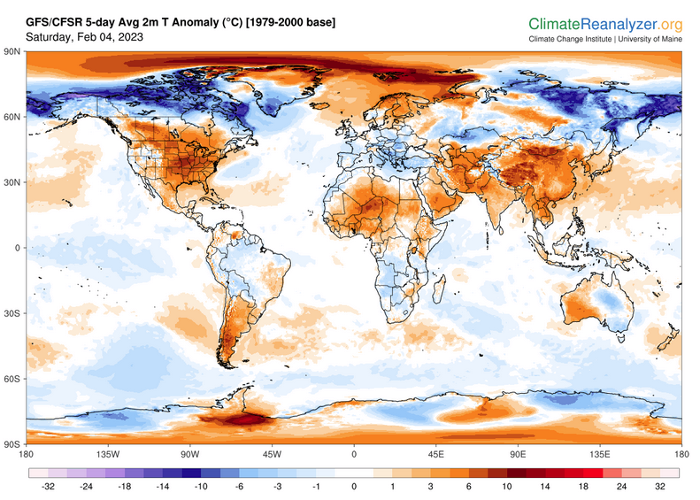
Below are the 5-Day forecasts for temperature and precipitation. Updates and much additional information can be obtained HERE
This information is provided by the University of Maine. They draw upon many different sources. There is a lot of information available at the link provided. I have just provided two useful forecasts. There are probably over a hundred different forecasts available from this source.
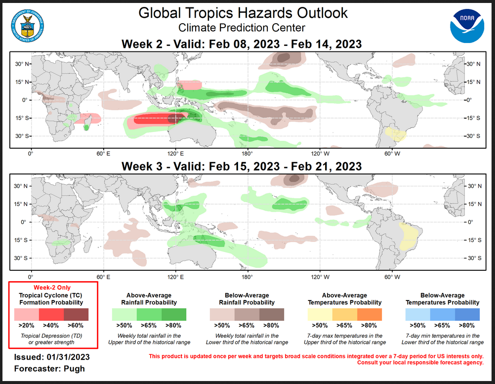
Worldwide Tropical Forecast (This is a NOAA Product)
This graphic updates on Tuesdays) If it has not been updated, you can get the update by clicking h ere Readers will only have to do that if they are reading this article much later than the date of it being published.-
–
| I hope you found this article interesting and useful. |