From the December 31, 2024 update of the January Weather Outlook:
Dynamical model forecasts of the Realtime Multivariate MJO (RMM) index are in agreement favoring continued eastward progression of the MJO signal over the next two weeks, which typically leads to increased troughing over the central and eastern Contiguous United States (CONUS), consistent with a negative Arctic Oscillation and [Author added for clarity: “and a negative] North Atlantic Oscillation. Overall, the more certain MJO forecasts and subsequent eastern CONUS troughing will allow for the potential for cooler air from the North entering the eastern CONUS during January.
So I thought it would be useful to discuss the MJO and raise the question as to the validity of the above statement.
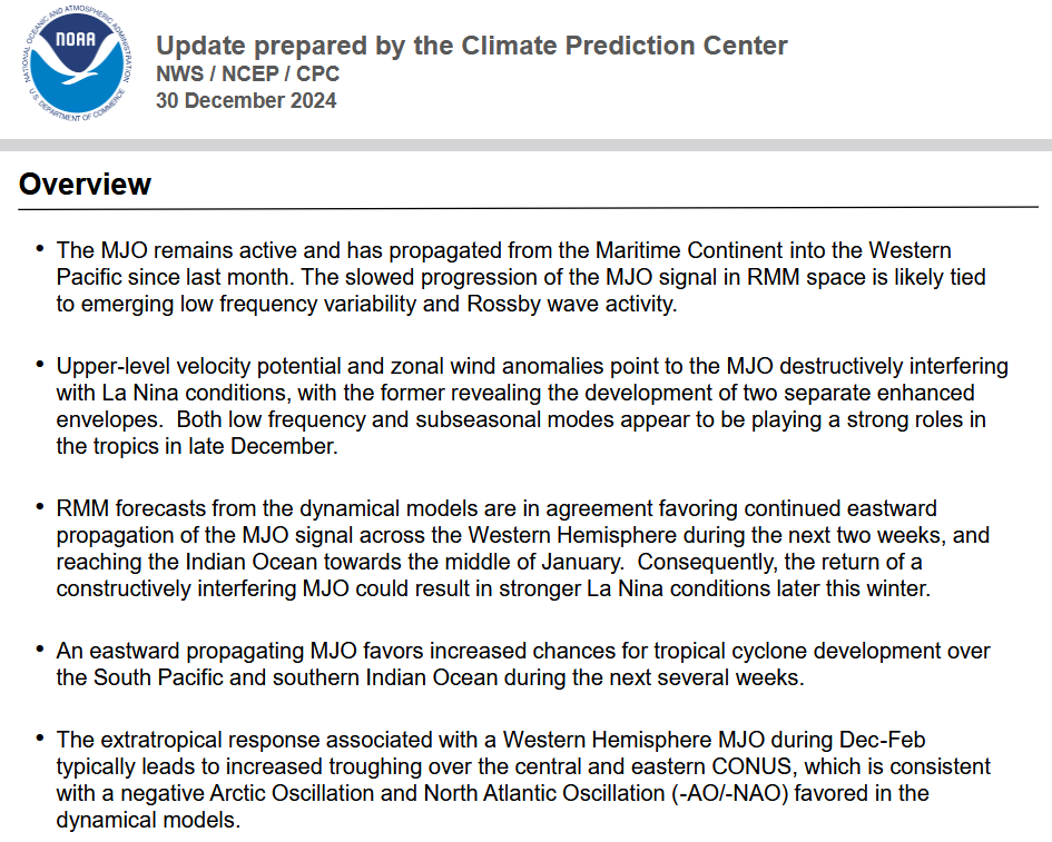
From the NOAA CPC:
The discussion above is confusing and may not be fully explanatory. It is clear that the CPC believes this instance of the MJO will be stronger than usual and interact with the development of the La Nina. Weather-speak can be confusing. “Constructively interfering” actually means enhancing. The last bullet point is to me concerning. Are they saying that the MJO is causing the Negative AO and NAO? I think that is a stretch (however, at the end of the article I revised my initial assessment after a few hours of additional research on Sunday a.m.) but there is a lot I do not understand about the MJO which is itself not well understood.
So I am not prepared to tackle that last issue (I did tackle it after publication late Saturday night/early Sunday morning raising my confidence in the January Outlook). Instead in parts II and III of this article, I present some basic information on this strange but important weather pattern: The Madden-Julian Oscillation (MJO).
Some will have to click on “Read More” to access the body of this article. It is mostly for those who are interested in learning about some of the less talked about patterns caused by the rotation of the Earth.
Part II
Most of what follows is from an article written by someone I know pretty well. He wrote it a while ago and until very recently there has not been much new research on the MJO. That is changing. This article has been published in many places and may have first appeared on Climate.gov but it shows up in many places. What is most interesting perhaps is that the MJO is a tropical pattern that sometimes can impact the mid-latitudes. Jon unfortunately does not explain how that can happen in this article but I believe it has to do with Rossby Waves which are sometimes called Planetary waves. That is the way the heat balance between the Equator and the Poles remains in balance. Such a mechanism can transmit what goes on along the Equator to the mid-latitudes which is how El Nino and La Nina can impact the mid-latitudes.
By Jon Gottschalck
Published December 31, 2014
The articles posted on this blog have described ENSO, its regional and global impacts, and the challenge of forecasting it, among several other topics. Here we introduce another important player on the tropical stage: the Madden-Julian Oscillation, or MJO. While the MJO is a lesser-known phenomenon, it can have dramatic impacts in the mid-latitudes. Several times a year the MJO is a strong contributor to various extreme events in the United States, including Arctic air outbreaks during the winter months across the central and eastern portions of the United States.
So what is the MJO?
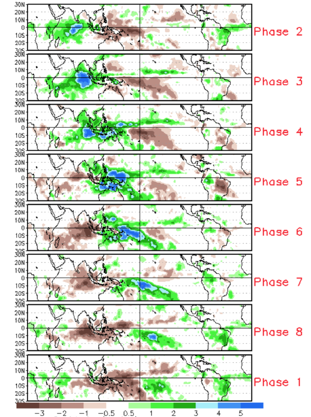
Imagine ENSO as a person riding a stationary exercise bike in the middle of a stage all day long. His unchanging location is associated with the persistent changes in tropical rainfall and winds that we have previously described as being linked to ENSO. Now imagine another bike rider entering the stage on the left and pedaling slowly across the stage, passing the stationary bike (ENSO), and exiting the stage at the right. This bike rider we will call the MJO and he/she may cross the stage from left to right several times during the show. So, unlike ENSO, which is stationary, the MJO is an eastward moving disturbance of clouds, rainfall, winds, and pressure that traverses the planet in the tropics and returns to its initial starting point in 30 to 60 days, on average. This atmospheric disturbance is distinct from ENSO, which once established, is associated with persistent features that last several seasons or longer over the Pacific Ocean basin10. There can be multiple MJO events within a season, and so the MJO is best described as intraseasonal tropical climate variability (i.e. varies on a week-to-week basis). The MJO was first discovered in the early 1970s by Dr. Roland Madden and Dr. Paul Julian when they were studying tropical wind and pressure patterns. They often noticed regular oscillations in winds (as defined from departures from average) between Singapore and Canton Island in the west central equatorial Pacific (Madden and Julian, 1971; 1972; Zhang, 2005). The MJO consists of two parts, or phases: one is the enhanced rainfall (or convective) phase and the other is the suppressed rainfall phase. Strong MJO activity often dissects the planet into halves: one half within the enhanced convective phase and the other half in the suppressed convective phase. These two phases produce opposite changes in clouds and rainfall and this entire dipole (i.e., having two main opposing centers of action) propagates eastward. The location of the convective phases are often grouped into geographically based stages that climate scientists number 1-8 as shown in Figure 1.
Figure 1: Difference from average rainfall for all MJO events from 1979-2012 for November-March for the eight phases described in the text. The green shading denotes above-average rainfall, and the brown shading shows below-average rainfall. To first order, the green shading areas correspond to the extent of the enhanced convective phase of the MJO and the brown shading areas correspond to the extent of the suppressed convective phase of the MJO. Note eastward shifting of shaded areas with each successive numbered phase as you view the figure from top to bottom.
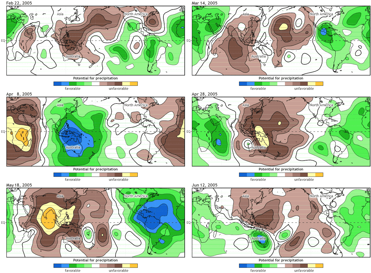
For the MJO to be considered active, this dipole of enhanced/suppressed convective phases must be present and shifting eastward with time. An animated illustration that depicts the global scale and eastward propagation of these two phases of the MJO is shown here (Fig. 2: animation).
Figure 2. An animation illustrating the organization of the MJO into its enhanced and suppressed convective phases during an MJO event during the spring of 2005. The green shading denotes conditions favorable for large-scale enhanced rainfall, and the brown shading shows conditions unfavorable for rainfall. The MJO becomes organized during late March through May as the green shading covers one half of the planet, and brown shades the other half all along as these areas move west to east with time. Notice how the shading returns to the same location on the order of about 45 days.
What’s behind the pattern?
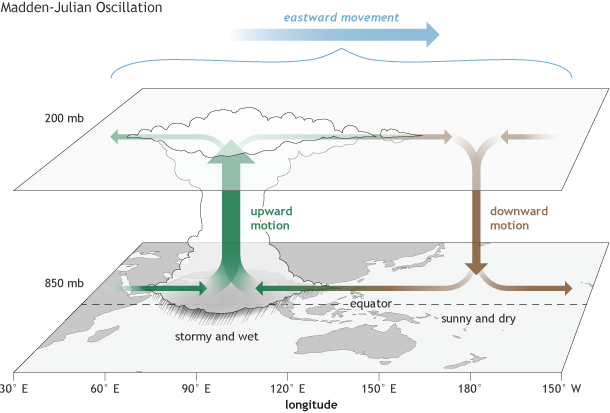
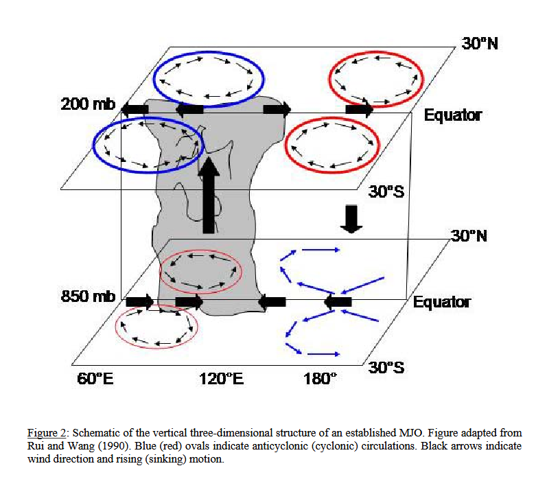
Let’s dig a little deeper and look at some of the characteristics within these two convective phases (Figure 3). In the enhanced convective phase, winds at the surface converge, and air is pushed up throughout the atmosphere. At the top of the atmosphere, the winds reverse (i.e., diverge). Such rising air motion in the atmosphere tends to increase condensation and rainfall.
The surface and upper-atmosphere structure of the MJO for a period when the enhanced convective phase (thunderstorm cloud) is centered across the Indian Ocean and the suppressed convective phase is centered over the west-central Pacific Ocean. Horizontal arrows pointing left represent wind departures from average that are easterly, and arrows pointing right represent wind departures from average that are westerly. The entire system shifts eastward over time, eventually circling the globe and returning to its point of origin. Climate.gov drawing by Fiona Martin.
In the suppressed convective phase, winds converge at the top of the atmosphere, forcing air to sink and, later, to diverge at the surface (Rui and Wang, 1990). As air sinks from high altitudes, it warms and dries, which suppresses rainfall. It is this entire dipole structure, illustrated in Figure 3, that moves west to east with time in the Tropics, causing more cloudiness, rainfall, and even storminess in the enhanced convective phase, and more sunshine and dryness in the suppressed convective phase. The changes in rainfall and winds described above impact both the Tropics and the Extratropics, which makes the MJO important for extended-range weather and climate prediction over the U.S. and many other areas. The MJO can modulate the timing and strength of monsoons (e.g., Jones and Carvalho, 2002; Lavender and Matthews, 2009), influence tropical cyclone numbers and strength in nearly all ocean basins (e.g., Maloney and Hartmann, 2000), and result in jet stream changes that can lead to cold air outbreaks, extreme heat events, and flooding rains over the United States and North America (Higgins et al. 2000, Cassou, 2008, Lin et al. 2009, Zhou et al., 2012, Riddle et al., 2013, Johnson et al., 2014). The MJO can produce impacts similar to those of ENSO, but which appear only in weekly averages before changing, rather than persisting and therefore appearing in seasonal averages as is the case for ENSO. Future posts will focus on the details of how we monitor and assess the strength of the MJO, provide details on impacts and the reasons for those impacts, and describe the current state of MJO predictability. Realtime MJO information that is updated daily or weekly can be found on the NOAA CPC MJO webpage.
References
Madden R. and P. Julian, 1971: Detection of a 40-50 day oscillation in the zonal wind in the tropical Pacific, J. Atmos. Sci., 28, 702-708. Madden R. and P. Julian, 1972: Description of global-scale circulation cells in the tropics with a 40-50 day period. J. Atmos. Sci., 29, 1109-1123. Cassou, C., 2008: Intraseasonal interaction between the Madden Julian Oscillation and the North Atlantic Oscillation. Nature, 455, 523-527 doi:10.1038/nature07286 Letter Higgins, W., J. Schemm, W. Shi, and A. Leetmaa, 2000: Extreme precipitation events in the western United States related to tropical forcing. J. Climate, 13, 793-820. Nathaniel C. Johnson, Dan C. Collins, Steven B. Feldstein, Michelle L. L’Heureux, and Emily E. Riddle, 2014: Skillful Wintertime North American Temperature Forecasts out to 4 Weeks Based on the State of ENSO and the MJO*. Wea. Forecasting, 29, 23-38. Jones, C. and L. Carvalho, 2002: Active and Break phases in the South American Monsoon System. J. Climate, 15, 905-914. Lavender, S. and A. Matthews, 2009: Response of the West African monsoon to the Madden-Julian Oscillation, J. Climate, 22, 4097-4116. Maloney E. and D. Hartmann, 2000: Modulation of hurricane activity in the Gulf of Mexico by the Madden-Julian Oscillation. Science, 287, 2002-2004. Riddle, E. E., M. B. Stoner, N. C. Johnson, M. L. L’Heureux, D. C. Collins, and S. B. Feldstein, 2013: The impact of the MJO on clusters of wintertime circulation anomalies over the North American region. Climate Dyn., 40, 1749-1766. Zhang, C., 2005: Madden-Julian Oscillation. Reviews of Geophysics, 43, 1-36. Zhou S., M. L’Heureux, S. Weaver, and A. Kumar, 2012: A composite study of MJO influence on the surface air temperature and precipitation over the Continental United States. Climate Dyn., 38, 1459-1471.
Part III
Here is a more detailed version of the above MJO Walker Circulation graphic:
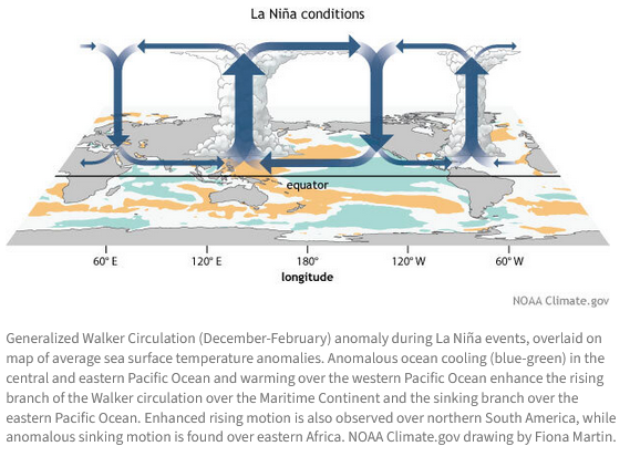
But how do the MJO and ENSO interact? The MJO leads with a downdraft followed by a powerful updraft. La Nina has updrafts and down drafts as shown below. the MJO is moving, the La Nina is stationary in the short term. So one can imagine how the MJO can decrease or reinforce either the updraft or downdraft of a typical La Nina (or El Nino or ENSO Neutral) pattern. Typically this would be west of the U.S. The MJO weakens when it is not over warm tropical water.
This article would seem to apply also
Notice they will not use the word Modoki. I provide THIS LINK mostly for my benefit for future articles.
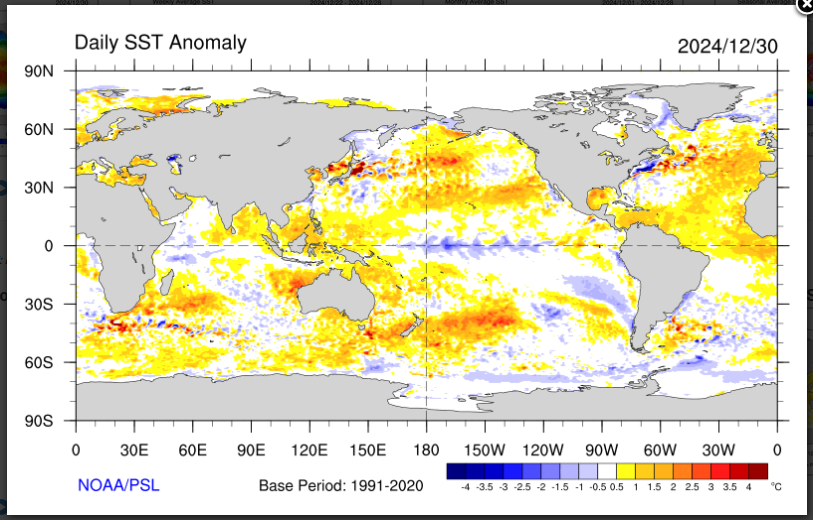
But this is not an Eastern Pacific La Nina if it is a La Nina at all which I doubt. It is focused in the Central Pacific.
See where the blue along the Equator is.
I may not know enough. I acknowledge that. But I do not think that NOAA has fully explained their January forecast. It may work out as they project but I do not think their explanation is adequate to say the least. I would have appreciated somewhat more detail in their discussion. My analysis suggests that the CPC may indeed be correct. This may well be a relatively rare combination of the location (Phase) of the MJO with this time of the year. I acknowledge that a full explanation would have been very complex. The resources I provide below would be sufficient to do that analysis which I have done post-publication of the article when I was more awake and alert i.e. today early Sunday morning January 5, 2024.
Let us not forget about Global Warming. The overall warmer surface temperatures of oceans make historical data much less useful. This partially invalidates statistical models. Dynamical models in theory would not be impacted but they are calibrated with historical data. This problem is not discussed very much but to me it is a major problem for weather forecasting.
Resources for those who wish to track some of the processes discussed in this article.
CPC MJO Page can be accessed HERE.
From within that page the following explanation is important: “Right 8 panels: Displayed as in the left panel except showing the level of statistical significance. Purple/blue shaded areas (lower percentages) represent regions that have higher levels of statistical significance according to a Monte Carlo test (see details in methodology). In these plots, a significance level of 5% means that there is a 5% chance that the anomalies arise from random chance (also known as the 95% confidence level).”
CPC Arctic Oscillation Page can be accessed HERE.
CPC North Atlantic Oscillation Page can be accessed HERE.
CPC PNA Pacific / North American Pattern Page can be accessed HERE.
In each case, among much other information, there is a graphic showing the recent history and the short-term forecast. If you click on it you will see more information about the forecast.
–
| I hope you found this article interesting and useful. |
