
The Japan Agency for Marine-Earth Science and Technology, or JAMSTEC, is a Japanese national research institute for marine-earth science and technology
From the JAMSTEC Discussion:
“The latest observations show that there are weak signs of a La Niña. However, the SINTEX-F ensemble mean predicts that a La Niña Modoki will develop in the boreal autumn and persist into the boreal winter, although there is a large uncertainty in the timing and amplitude of the event.”
Although it is a World forecast, it includes a forecast for North America since North America is part of the World. One might try to compare it to the NOAA Outlook we published recently which can be accessed HERE.
First, we take a look at the forecasted sea surface temperature anomalies (SSTA). JAMSTEC starts by forecasting the SSTA and Nino 3.4 Index on the first day of the month and from there it usually takes their models about two weeks to produce their seasonal forecast. I received it from JAMSTEC on September 25 which was much later than when NOAA issued their Seasonal Update this month. The JAMSTEC model runs are based on conditions as of September 1, 2024. The NOAA Seasonal Outlook is based on conditions closer to the time when it was issued.
We do not have a full three-season forecast from JAMSTEC this month. We have forecast maps for OND, DJF and MAM so it is really an eight-month forecast as OND and DJF overlap a bit. For each of these three-month Outlooks, I also show the corresponding NOAA Precipitation Outlook for comparison purposes. The two are remarkably similar which is very unusual.
We also have single-month JAMASTEC forecasts for October through March 2025. I have a single-month outlook for October from NOAA but not single-month outlooks for the other five months so I could not show those comparisons.
Let’s take a look.
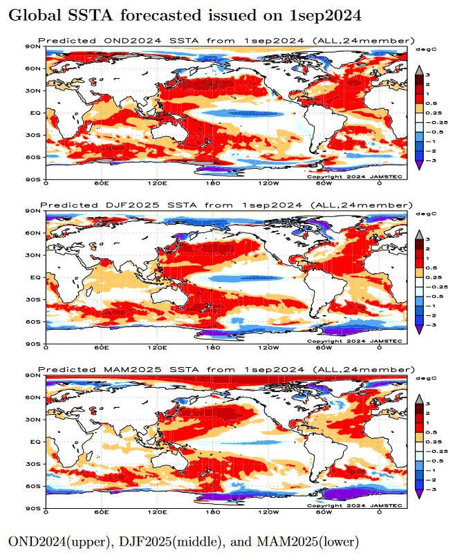
| This shows their forecast of sea surface temperature anomalies at three points in time. Blue is a cold anomaly and is associated with La Nina if it occurs in the Nino 3.4 measurement areas in the Pacific along the Equator. The cool anomaly along the Equator is somewhat further west than usual which gives it the Modoki characteristics.
The U.S. funded some of the Modoki research but for some reason declines to mention it in their seasonal outlook discussions. In the OND image above, look at that blob of cool (anomaly) water to the west along the Equator. Thus the La Nina has Modoki characteristics that impact the Walker circulation. I have written about that before. It raises questions about the reliability of our current approach to thinking about the ENSO Cycle. This is covered in another article that can be accessed HERE. Of interest also is the neutrally cold water just off the West Coast of the U.S. and the warm water between Africa and the north coast of South America which can support tropical storms and hurricanes. NOAA publishes a similar SSTA analysis. It can be accessed HERE. JAMSTEC uses the same definition of Normal (climatology) as NOAA. JAMSTEC does a better job at characterizing La Ninas and El Ninos than NOAA. JAMSTEC provides me with a lot of other information that I do not include in my articles to keep them to a manageable size for readers. That material is the atmospheric pressure patterns. |
Some Readers will have to click on “Read More” to read the rest of the article which you need to read to see the forecasts. I can only include a certain amount of material in the lede.
Then we look at three forecasts. As discussed earlier, JAMSTEC tries to work with meteorological seasons and this month it does not line up perfectly since we have OND, DJF and MAM. Next month it also will not line up perfectly as we will have NDJ, DJF and MAM. The following month we will have DJF, MAM, and JJA.
Now we look at the three three-month forecasts that were provided two of which overlap to some extent.
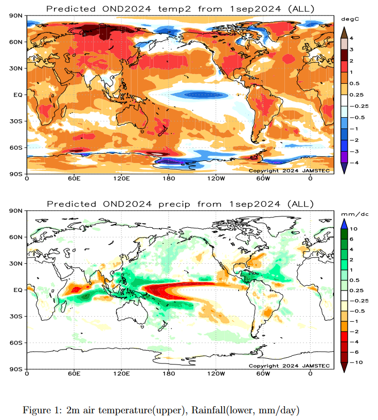
| The above covers October/November/December 2024
“The SINTEX-F predicts warmer than normal conditions for most of the globe during the October-December mean, except for Central America, India, some parts of Indochina, some parts of Indonesia, some parts of Europe, and eastern Siberia.” “In terms of October-December mean precipitation, drier-than-normal conditions are predicted for the southern United States, California, Mexico, some parts of the South American continent, Myanmar, southern China, and some parts of Europe. On the other hand, wetter-than-normal conditions are predicted for Alaska, a western coastal part of Canada, some parts of Central America, the Caribbean, some parts of the South American continent, the western Pacific Islands, New Zealand, central Africa, Mozambique, central India, the Philippines, Indonesia, and some parts of northern Europe and some parts of Russia. ” “During the October-December average and winter, the model predicts that most of Japan will be warmer than normal. “ |
NOAA Precipitation Outlook for this period.
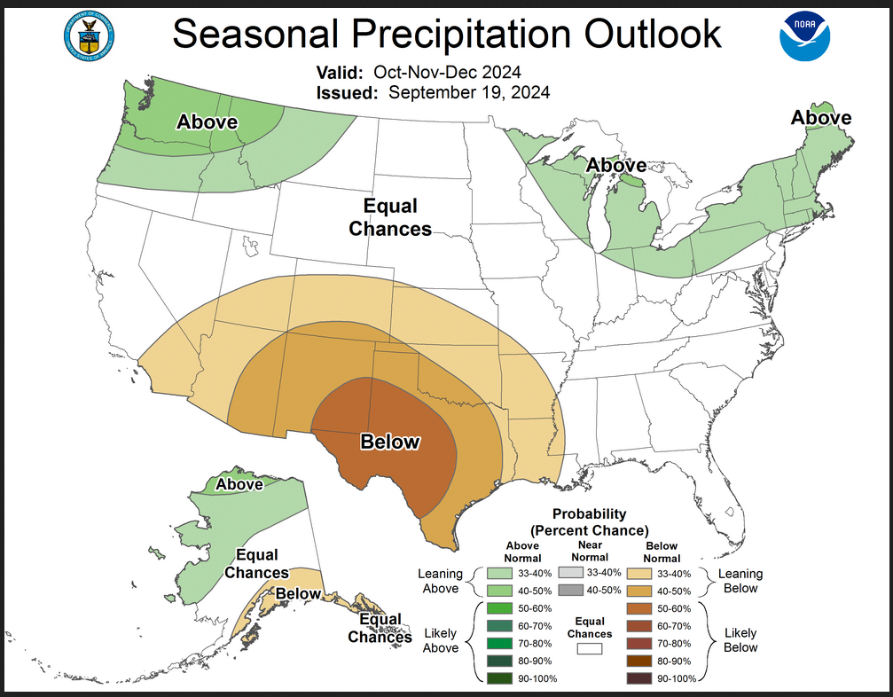
| The JAMSTEC Outlook looks a lot like the NOAA Outlook but the dry anomaly is to the east in the JAMSTEC analysis but it is along the southern tier in both cases. |
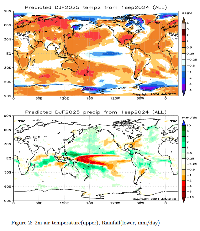
| The above covers December/January, February 2024-2025 which is Winter.
Here is the interpretation from the JAMSTEC discussion: “During the boreal winter, the SINTEX-F still predicts warmer than normal conditions for most of the globe, except for eastern/western Canada, Central America, some parts of Brazil, central/northern Africa, some parts of Saudi Arabia, some parts of Indochina, India, and eastern Siberia.” “During the boreal winter, drier-than-normal conditions are predicted for the southern United States, the La Plata Basin, some parts of southern Africa, and some parts of Indonesia. In contrast, wetter-than-normal conditions are predicted for some parts of Alaska, northern South America, northern/eastern Australia, the western Pacific Islands, New Zealand, southeastern South Africa, some parts of Madagascar, some parts of Mozambique, and some parts of Indonesia, and the Philippines.” “During the October-December average and winter, the model predicts that most of Japan will be warmer than normal.” |
NOAA Precipitation Outlook for this period.
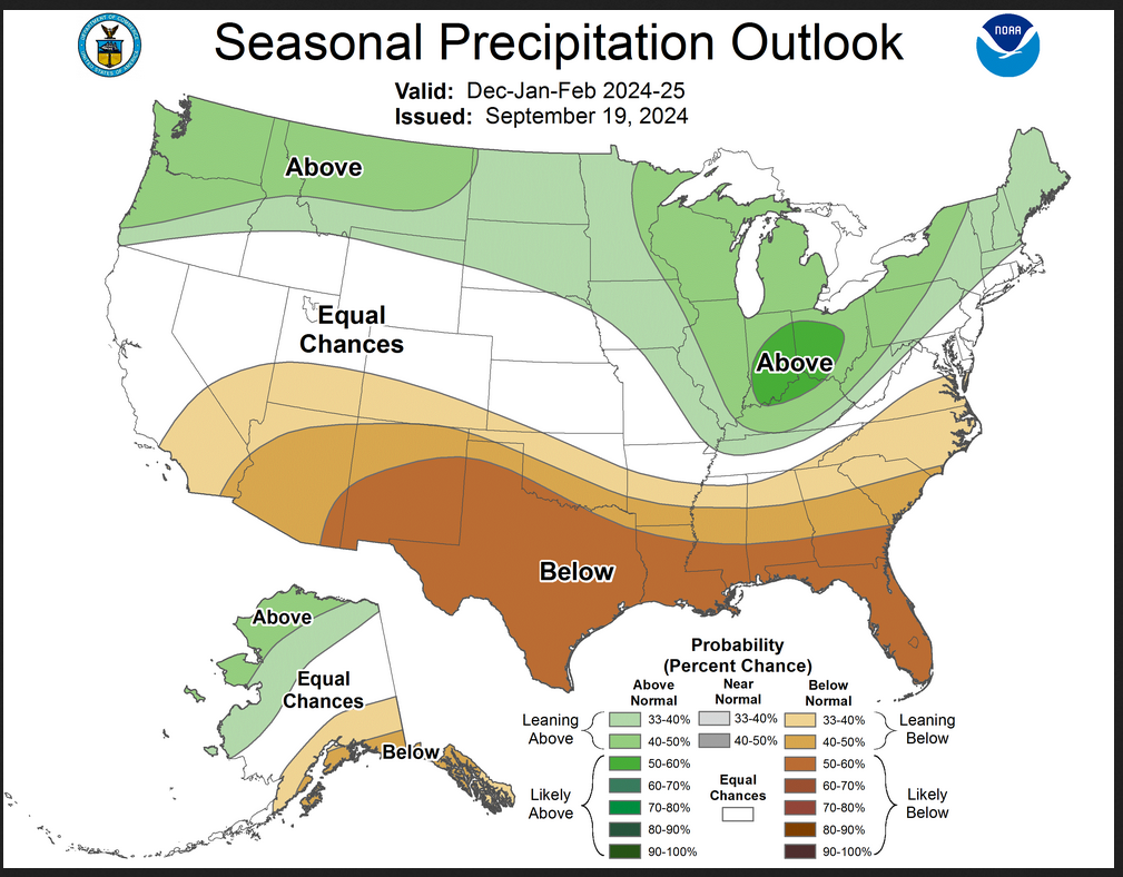
| The JAMSTEC Outlook looks a lot like the NOAA Outlook but JAMSTEC shows the dry area mostly to the east but still in the southern tier. |
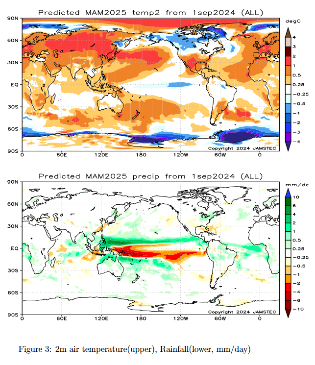
| The above covers March/April. May which is Spring.
JAMSTEC does not provide a commentary for the third season map but the reader can interpret it themselves.
|
NOAA Precipitation Outlook for this period.
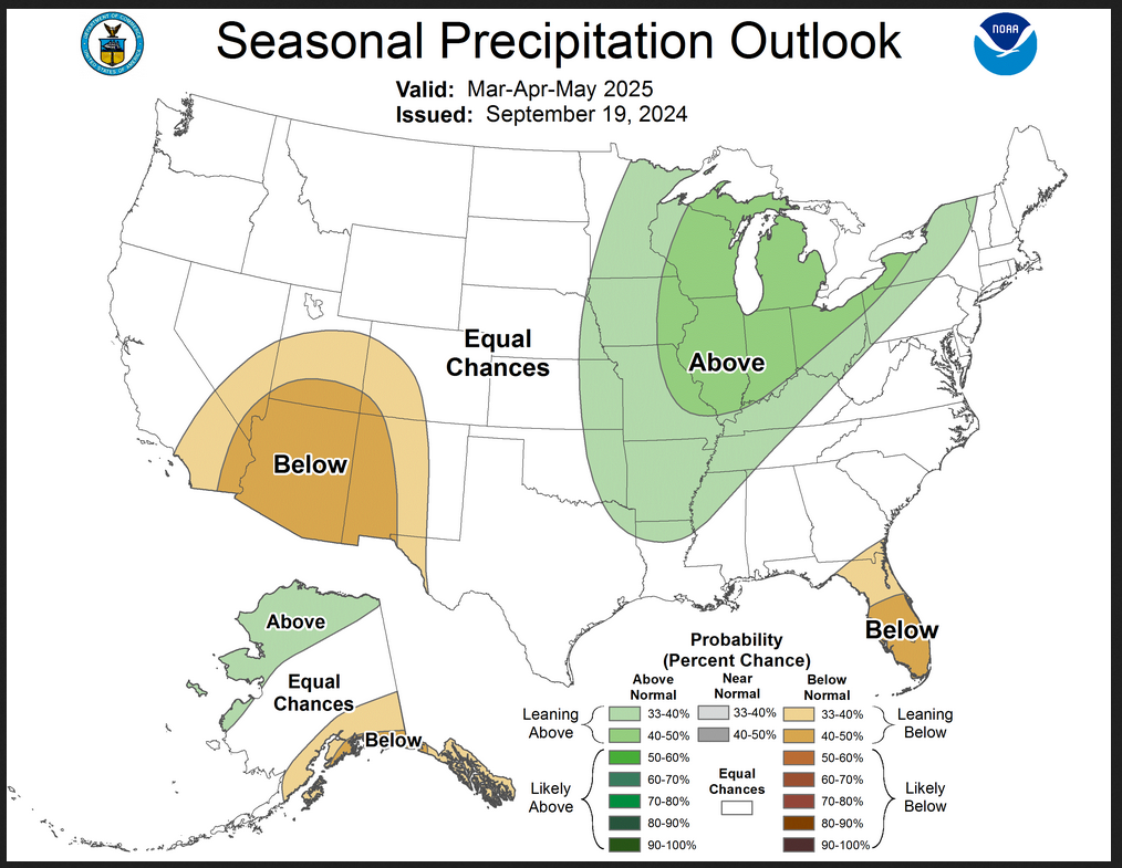
| The JAMSTEC Outlook looks a lot like the NOAA Outlook but the Southern Tier dryness is not shown for the Southwest. What is shown by JAMSTEC and NOAA is a wet anomaly that includes the Great Lakes but the NOAA outlook has this wet anomaly extending more into the U.S. |
Now I am going to provide their single-month forecasts for October, November and December 2024 and January, February and March 2025.
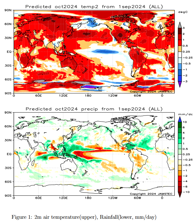
| The above is the single month of October 2024. It is interesting as a world forecast but since the U.S. is part of the world it also provides a U.S. forecast. |
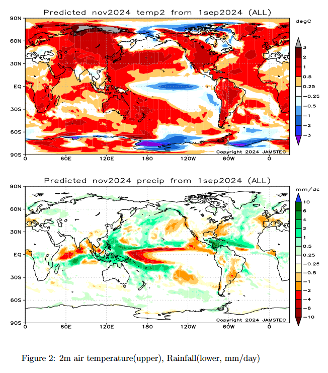
| The above is the single month of November 2024. |
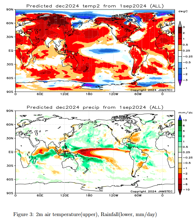
| The above is the single month of December 2024. |
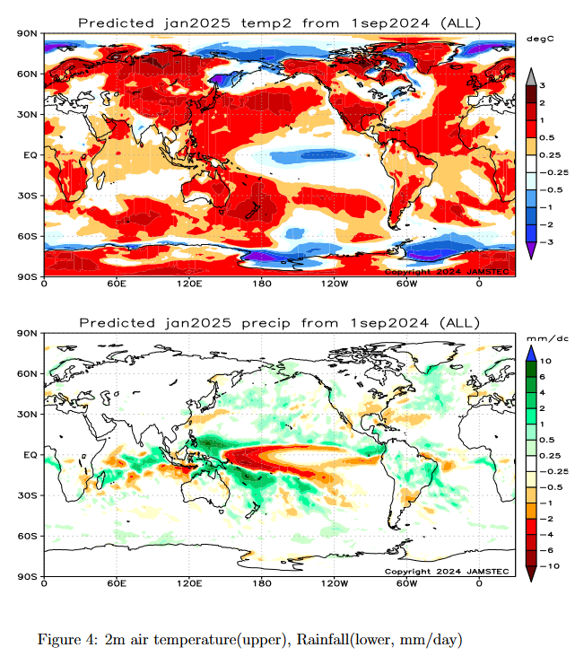
| The above is the single month of January 2025. |
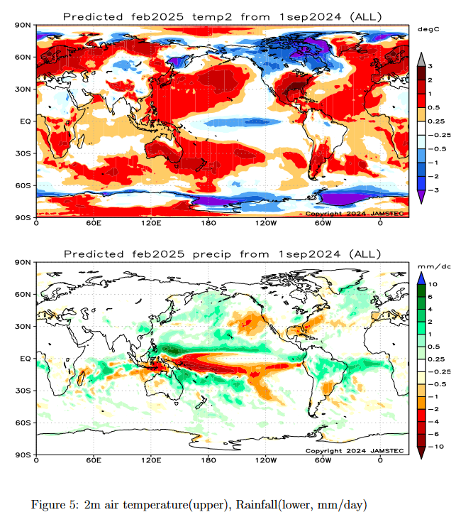
| The above is the single month of February 2025. |
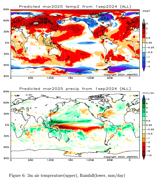
| The above is the single month of March 2025. |
Now we look at the key indices used by JAMSTEC in making their forecast. Perhaps I should have presented these first.
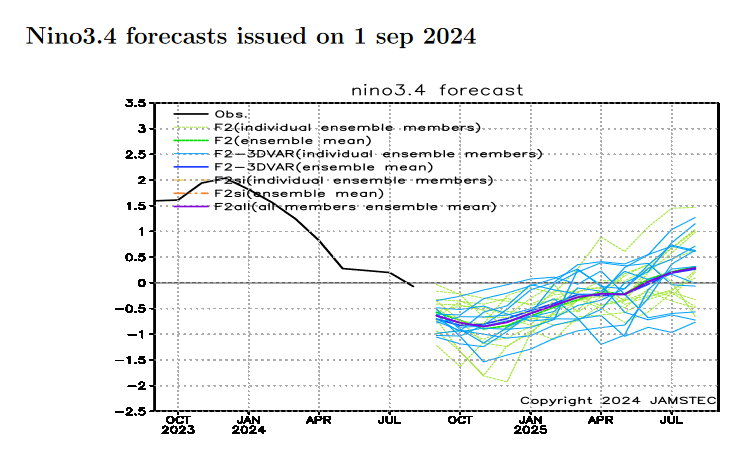
| This forecast is for a marginal and shorter La Nina which is different from what NOAA is forecasting. |
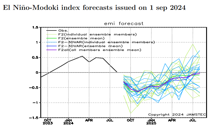
| I am showing the Modoki Index this month. It is a bit different than the Nino 3.4 index but not by very much. |
And here is the short JAMSTEC Discussion which I have already included with each of the seasonal forecast maps.
ENSO forecast:
The latest observations show that there are weak signs of a La Niña. However, the SINTEX-F ensemble mean predicts that a La Niña Modoki will develop in the boreal autumn and persist into the boreal winter, although there is a large uncertainty in the timing and amplitude of the event.
Indian Ocean forecast:
An above-normal temperature is observed in the tropical Indian Ocean, indicating a positive phase of the Indian Ocean Basin Mode. The SINTEX-F predicts that the positive phase of the Indian Ocean Basin Mode will weaken during the boreal autumn, and then the tropical Indian Ocean will be in a neutral state during the boreal winter.
Regional forecast:
The SINTEX-F predicts warmer than normal conditions for most of the globe during the October-December mean, except for Central America, India, some parts of Indochina, some parts of Indonesia, some parts of Europe, and eastern Siberia. During the boreal winter, the SINTEX-F still predicts warmer than normal conditions for most of the globe, except for eastern/western Canada, Central America, some parts of Brazil, central/northern Africa, some parts of Saudi Arabia, some parts of Indochina, India, and eastern Siberia.
In terms of October-December mean precipitation, drier-than-normal conditions are predicted for the southern United States, California, Mexico, some parts of the South American continent, Myanmar, southern China, and some parts of Europe. On the other hand, wetter-than-normal conditions are predicted for Alaska, a western coastal part of Canada, some parts of Central America, the Caribbean, some parts of the South American continent, the western Pacific Islands, New Zealand, central Africa, Mozambique, central India, the Philippines, Indonesia, and some parts of northern Europe and some parts of Russia. During the boreal winter, drier-than-normal conditions are predicted for the southern United States, the La Plata Basin, some parts of southern Africa, and some parts of Indonesia. In contrast, wetter-than-normal conditions are predicted for some parts of Alaska, northern South America, northern/eastern Australia, the western Pacific Islands, New Zealand, southeastern South Africa, some parts of Madagascar, some parts of Mozambique, and some parts of Indonesia, and the Philippines.
During the October-December average and winter, the model predicts that most of Japan will be warmer than normal.
–
| I hope you found this article interesting and useful |