The mission of the National Weather Service Colorado Basin River Forecast Center (CBRFC) is to produce river, flood, and water supply forecasts for the Colorado Basin and the Great Basin in support of saving lives and property and to enhance the region’s environment and economy.
In this article, I am providing a summary of their Water Supply Forecast Discussion released on January 17, 2024. The situation is not very good. However due to a wet winter last winter, the reservoirs are mostly in good shape. 
I have also included information on the current reservoir storage levels including a few that are outside of the Colorado River Basin.
The image below shows part of the area covered in the CBRFC Report. The map shown here is only the Colorado Basin. The Eastern Great Basin is to the west of this map. The maps shown in the article cover both basins but are not as scenic as this map.
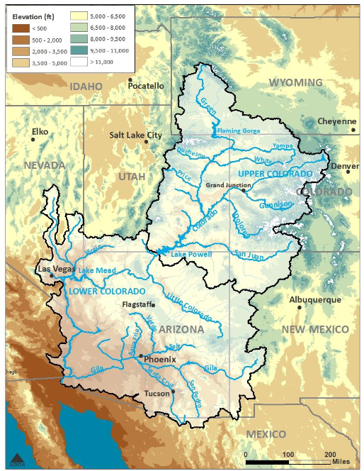
Map showing both the Colorado Basin and Eastern Great Basin.
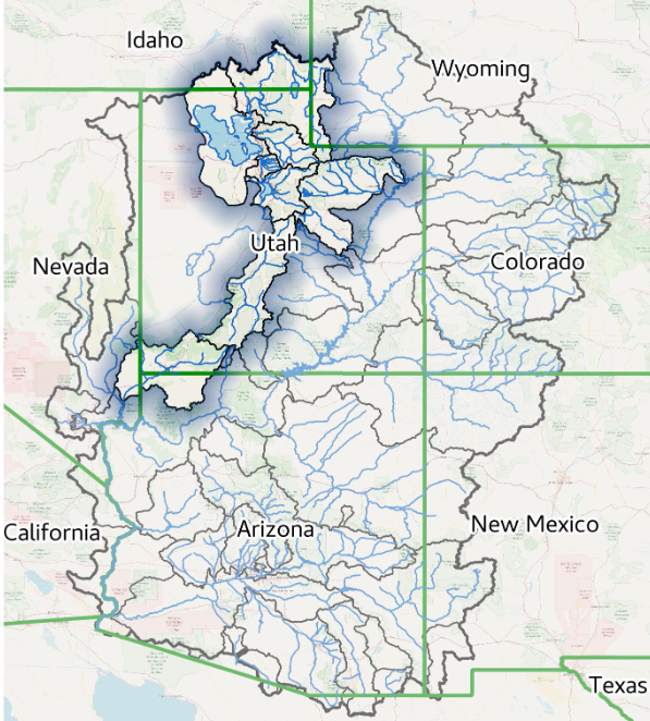
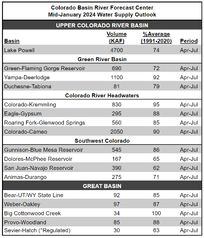
| Most of the information presented in this part of the article is from a summary report (Link) issued by the Colorado River Basin Forecast Center. January 17, 2023, Water Supply Forecast Discussion The Colorado Basin River Forecast Center (CBRFC) geographic forecast area includes the Upper Colorado River Basin (UCRB), Lower Colorado River Basin (LCRB), and Eastern Great Basin (GB). It is one of many similar organizations within the National Weather Service. They are all different. In the future, I will try to pay more attention to some of the other River Forecasting Centers but they do not all go out of their way to provide reports to the Media. But the Colorado River is a special situation in a way due to the problems complying with the Colorado River Compact. But all our rivers are important. At this time of the year, we are hopefully adding to the snowpack for future snowmelt. Additional information is available on the Center website (click HERE), there are certain graphics that update daily. And now I provide the main part of their new forecast discussion summary. I am copying directly from their document. My comments are in boxes. |
| The CBRFC weather forecast is for a changing weather pattern. For updated weather forecasts go to econcurrents.com
and look for the most recent Short-Term and Intermediate-Term Weather Outlooks article in the list of Recent Posts. |
Please click on “Read More” to read the rest of this article.
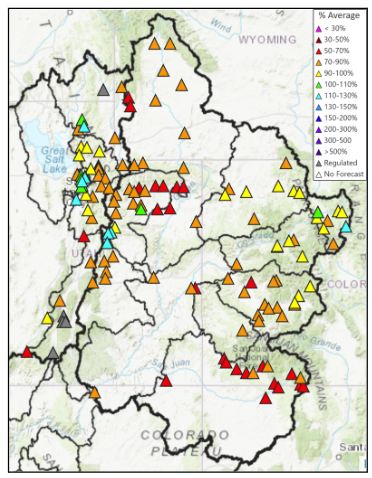
| Almost all areas are forecasting water supply to be less than 100% of Climatology defined as the 1991 – 2020 Average. For specific water supply forecasts click HERE |
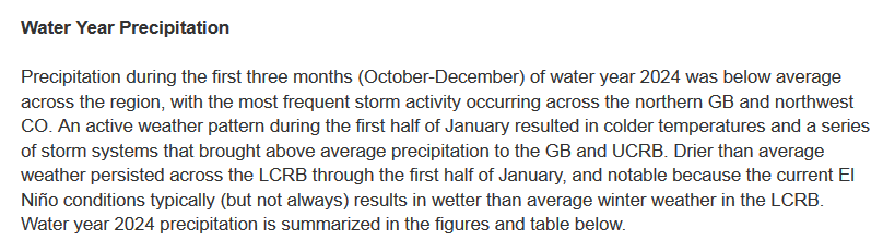
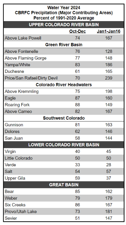
| Almost all areas are recording precipitation that has been less than 100% of Climatology defined as the 1991 – 2020 Average For the Water Year (Starts October ) through December and way above 100% for the first half of January. The precipitation maps for prior months can be viewed HERE |
| Almost all areas are forecasting more than 100% of Climatology defined as the 1991 – 2020 Average. |
Soil Moisture
For updated SNOTEL information click HERE
For CBRFC hydrologic model snow click HERE
For CBRFC’s beginning-of-the-month online publication that contains basin conditions, summary graphics,
and end-of-month reservoir content tables refer to the following links.
Basin Conditions and Summary Graphics
Green River Basin
Upper Colorado River Basin
San Juan River Basin
Great Salt Lake Basin
Sevier River Basin
Virgin River Basin
End Of Month Reservoir Content Tables
Green River Basin
Upper Colorado River Basin
San Juan River Basin
Great Salt Lake Basin
Sevier Basin
Explanation of Abbreviations

That completes what we are reporting for CBRFC. From a Different Source (USBR.gov) and Covering a Larger Area and with some more recent data:

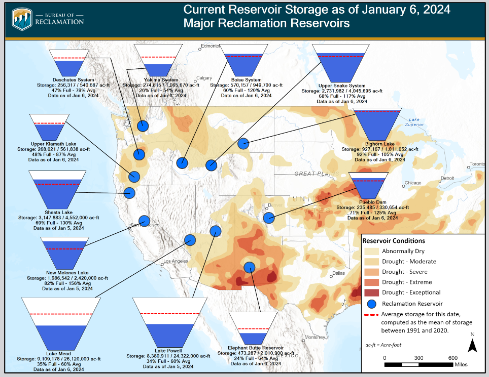
| Many reservoirs are back to their average or slightly above. Others are still below average but much above the desperate levels of last year. It will take a run of wet years to get Lakes Powell and Mead back to normal. Those two reservoirs do not empty each year so they represent true storage. Elephant Butte may have once been a storage dam but with Climate Change and the Negative Phase of the PDO Cycle, it generally releases what it receives during the irrigation season down to a safe storage level and other considerations. Click HERE to update this image. |
–
| I hope you found this article interesting and useful. |
–