At the end of every month, NOAA updates its Outlook for the following month which in this case is November of 2023. We are reporting on that tonight.
There have been some significant changes in the Outlook for November and these are addressed in the NOAA Discussion so it is well worth reading. We provided the prior Mid-Month Outlook for November for comparison. It is easy to see the changes by comparing the Mid-Month and Updated Maps.
The article includes the Drought Outlook for November. NOAA also adjusted the previously issued Seasonal Drought Outlook to reflect the changes in the November Drought Outlook. We have included a map showing the water-year-to-date precipitation. We also provide the Week 2/3 Tropical Outlook for the World.
The best way to understand the updated outlook for November is to view the maps and read the NOAA discussion. I have highlighted the key statements in the NOAA Discussion.
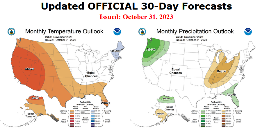
Here is the updated Outlook for November 2023
For Comparison Purposes, Here is the Mid-Month Outlook for November.
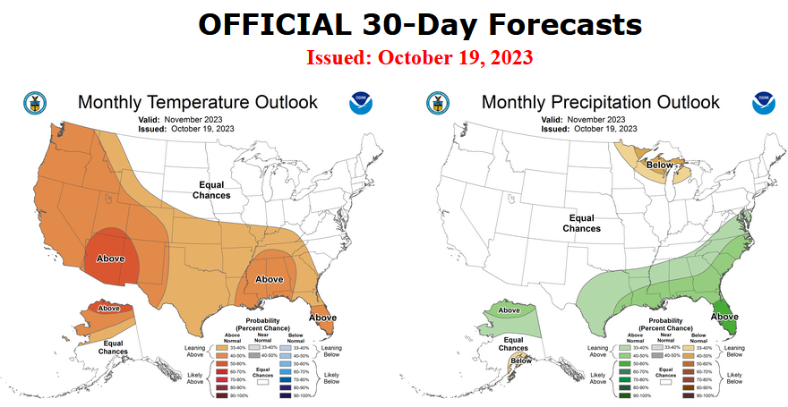
| There have been some significant changes especially related to precipitation. Remember, it is the top set of maps that are the current outlook for November. |
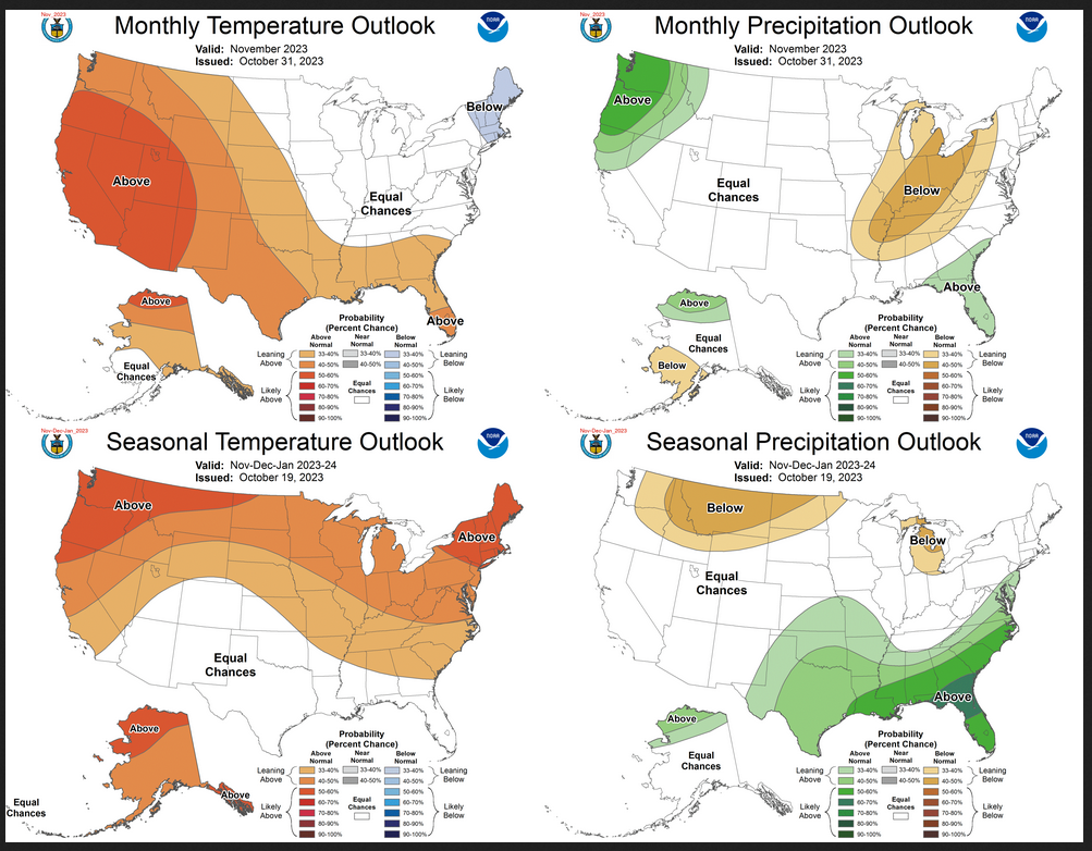
Combination of the Updated Outlook for November and the Three-Month Outlook
| Our regular Daily Weather article can be found HERE. In addition to the short-term forecast it also provides the 6 – 10 day, 8 – 14 day, and Week 3 – 4 Outlooks. That is not a full month but close to it. So it is helpful if one wants to understand how the full-month forecast is expected to vary through the month. And the maps in the Daily article update throughout the month. |
Here are larger versions of the Temperature and Precipitation Outlook maps.
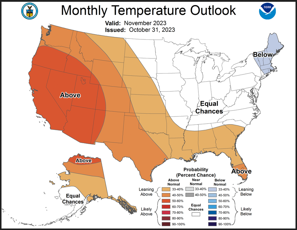
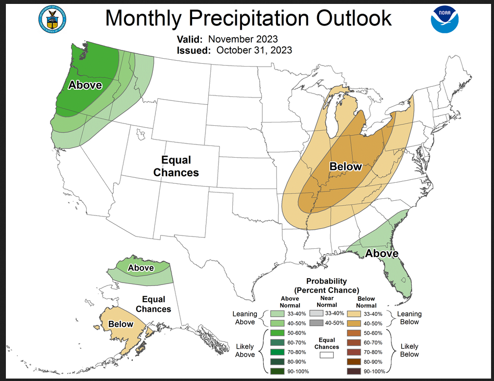
NOAA (Really the National Weather Service Climate Prediction Division CPC) Discussion. I have shown certain important points in bold type. My comments if any are in brackets [ ].
30-DAY OUTLOOK DISCUSSION FOR NOVEMBER 2023
The November Temperature and Precipitation Outlooks are updated considering current Weather Prediction Center (WPC) Outlooks for week 1, Climate Prediction Center (CPC) Extended Range and Subseasonal Outlooks, dynamical model guidance for week 2 and weeks 3-4, snow cover, background climate states, and recent Climate Forecast System version 2 (CFSv2) monthly forecasts of temperature and precipitation. Equatorial sea surface temperatures (SSTs) are above average across the central and eastern Pacific Ocean, and El Niño conditions are observed. Evolution of the Madden Julian Oscillation (MJO) is uncertain due to destructive interference from the active El Niño, and as such, El Niño remains the dominant teleconnection for temperature and precipitation over North America. Other influencing factors for the updated November Outlooks include sea surface temperature (SST) anomalies, which are above normal along much of the coast of Alaska, along the west coast of the Contiguous United States (CONUS), in the Gulf of Mexico, and along most of the East Coast. Additionally, anomalously high snow cover is present in the north-central CONUS, and sea ice is lower than the average near Alaska, which are also taken into consideration.
CPC 6-10 day forecasts (early November) of the 500-hPa circulation pattern favor ridging over western CONUS and troughing over eastern CONUS, with slight eastward progression of the pattern into the 8-14 day period (early to mid-November). Dynamical model predictions of Weeks 3-4 (mid- to late November) 500-hPa heights generally feature broad ridging across much of the CONUS, indicating that the pattern may shift near the middle of the month. Thus, the pattern is somewhat transient for at least the eastern part of the CONUS, which adds uncertainty to the forecast over the east, particularly for temperature.
Temperature
The updated Monthly Temperature Outlook remains similar to the previously released Outlook. A broad area of above normal temperatures is favored for the western half of the CONUS and the Gulf States. Given the persistent ridging over the western CONUS in early to mid-November, Week 34 guidance that favors broad ridging, and recent monthly CFSv2 forecasts of temperature that favor strong probabilities of above normal temperatures over the western half of the CONUS, confidence on above normal temperatures is increased compared to the mid-month Outlook (50 to 60 percent). In contrast, the early November troughing over the eastern CONUS is expected to bring short-lived below normal temperatures into the region, though later parts of the month may shift toward weakly above normal temperature probabilities. Above normal temperature probabilities over the Gulf States are weaker (33 to 40%) and shifted toward the coast compared to the mid-month Outlook due to the possibility of short lived below normal temperatures that may dip into the region early in the month. However, most models maintain ome above normal probabilities over the Gulf States throughout much of November and Gulf of Mexico SST anomalies are above normal, both of which support the weak tilt toward above normal. Equal chances of above, near, and below normal temperatures (EC) are favored for the region stretching from the north central CONUS to the east coast, where model uncertainty is high, as well as due to anomalously high snow cover over parts of the north central CONUS that could lead to cooler temperatures. A weak tilt toward below normal temperatures (33 to 40 percent) is indicated for New England, where most models and tools maintain the below normal signal throughout the month of November. The main change from the mid-month Temperature Outlook over Alaska is expansion of the region of above normal temperature probabilities given the lower than average sea ice and above normal SSTs.
Precipitation
Larger changes are evident for the updated November Precipitation Outlook, especially given model uncertainty for the mid-month Outlook which led to large areas of EC. Probabilities of above normal precipitation are elevated (50 to 60 percent) over the Northwest given expected early to mid-November above normal precipitation, and in agreement with the expected El Niño teleconnection. The area of below normal precipitation, previously favored over parts of the Great Lakes, is expanded to include parts of the Middle Mississippi, Lower Mississippi, Ohio and Tennessee Valley regions due to strong below normal precipitation probabilities in recent monthly CFSv2 forecasts, supported by Week 3-4 ECMWF forecasts of precipitation. Recent CFSv2 forecasts favor below normal precipitation all the way to the Gulf and east coasts, however, a weak tilt toward above normal is maintained over coastal parts of the Southeast due to potential for El Niño teleconnections and supported by Week 3-4 ECMWF forecasts. EC is favored for the Middle Atlantic and Northeast, again despite below normal monthly CFSv2 predictions, due to amplified storminess and risk of heavy precipitation along the coast as noted in the CPC U.S. Week-2 Hazards Outlook, however, there is considerable uncertainty surrounding this feature. Over Alaska, the updated Precipitation Outlook remains similar, with slight decrease in the area of favored above normal precipitation over the northern parts of the state, and expansion of the area of favored below normal precipitation over the southwestern parts of the state, consistent with updated dynamical model forecasts.
Drought Outlook
Here is the newly issued Drought Outlook for the month.
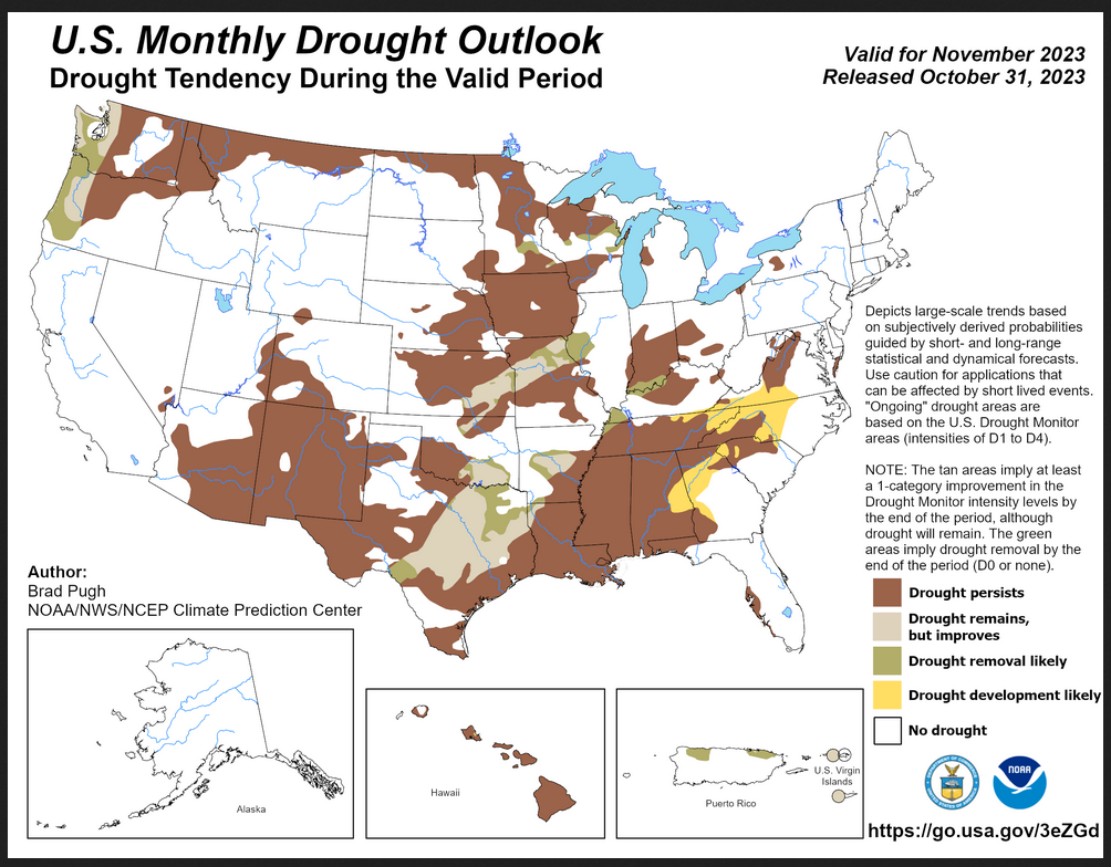
| You can see where drought development or reduction is likely. Overall the forecast is for a slight reduction of drought conditions. The summary and detailed discussions that accompany this graphic can be accessed HERE, but the short version is shown below. |
Here is the short version of the drought summary
Latest Monthly Assessment – Heavy precipitation during late October supports drought improvement or removal across parts of the Southern to Central Great Plains and Midwest. Since November is a relatively dry time of year, broad-scale persistence is the most likely outcome for the remainder of the ongoing drought areas of the central and eastern U.S. Development is favored for parts of the Southeast early in November, but the duration of this short-term drought is uncertain and it could be short-lived. Persistence is forecast for the Northern Rockies and Intermountain West, while the updated November precipitation outlook and climatology support improvement or removal across western parts of Oregon and Washington. Persistence is likely for Hawaii, while Alaska remains drought-free. Drought improvement or removal is likely to continue across Puerto Rico and the U.S. Virgin Islands.
We also have an updated Seasonal Drought Outlook (link).
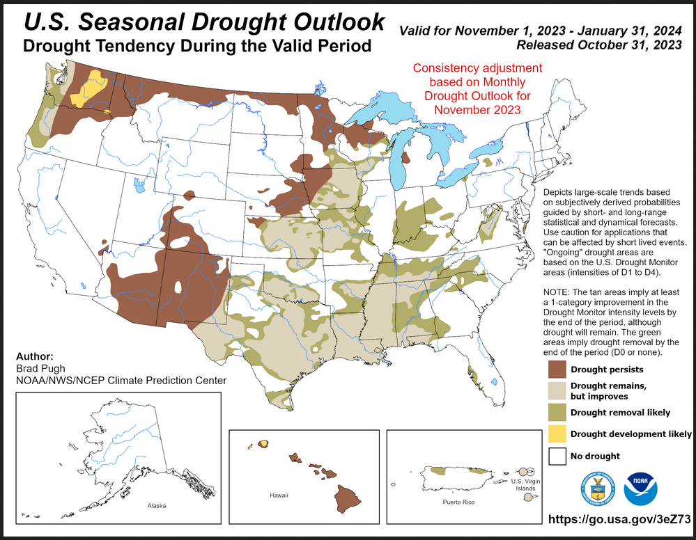
| It is this month quite different than the single-month outlook but it covers a longer period of time. It does not seem to be consistent with a strong El Nino but it does show significant improvement over current conditions. |
| To update this forecast (which updates on Tuesdays) click HERE |
Month-to-date Temperature as the current month evolves can be found at https://hprcc.unl.edu/products/maps/acis/MonthTDeptUS.png
Month-to-date Precipitation as the current month evolves can be found at https://hprcc.unl.edu/products/maps/acis/MonthPNormUS.png
CLIMAS Podcast
We do not have a CLIMAS Podcast this month.
Water-year-to-date precipitation. Here is the LINK
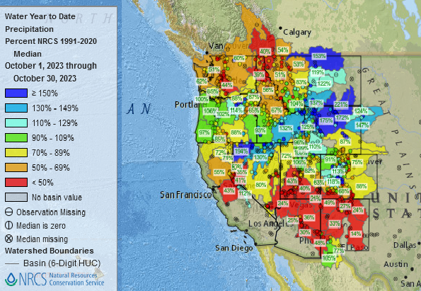
| This provides a very clear picture of the weather pattern since October 1, 2023 i.e. the first month of the water year. |
Fire Outlook (The Site has Moved and I have not figured out how to print images from the new site yet. The link is HERE.
| I hope you found this article interesting and useful |