The Japan Agency for Marine-Earth Science and Technology, or JAMSTEC, is a Japanese national research institute for marine-earth science and technology
From the JAMSTEC Discussion:
As predicted, the recent observation confirms the development of the El Niño. The SINTEX-F ensemble mean predicts that the El Niño will reach the peak in August and persist at least until the next boreal spring. However, there is a large uncertainty in the predicted amplitude.
Although it is a World forecast, it includes a forecast for North America since North America is part of the World.
First, we take a look at the forecasted sea surface temperature anomalies (SSTA). JAMSTEC starts by forecasting the SSTA and Nino 3.4 Index on the first day of the month and from there it takes their models about two weeks to produce their seasonal forecast. I received it from JAMSTEC on July 13, 2023.
| This shows their forecast of sea surface temperature anomalies at three points in time. Red is warm and is associated with El Nino. You can see the El Nino tongue of warm water extending from Peru to the west in all three time periods. It seems to be stronger in the 1st and 2nd time periods. The warmest water shifts west in the third period exhibiting Modoki characteristics. [I have similar information on their SSTA projections from NOAA but I usually do not include it in the article I write on the NOAA Seasonal Outlook because they do not seem to focus on it and their information does not extend as far into the future as does the information from JAMSTEC]. It is hard to find any blue in this set of forecasts but there is a bit of blue off of Baja California which is interesting. JAMSTEC uses the same definition of Normal (climatology as NOAA). They do a better job at characterizing La Ninas and El Ninos than NOAA. JAMSTEC provides me with a lot of other information that I do not include in my articles to keep them to a manageable size for readers. Yesterday we published the NOAA ENSO Advisory and our article can be accessed HERE. In that article, Emily Becker commented on the generally warm oceans and how this may make predicting the strength and duration of an El Nino difficult. |
Then we look at three forecasts. JAMSTEC tries to work with meteorological seasons and this month it does not line up perfectly. This means we do not have three full seasons of forecasts this month because the first three-month period overlaps the second one. ASO is one month of meteorological summer and two months of Autumn and SON is autumn. So we really have autumn and winter (DJF) with a forecast that is the transition to autumn.

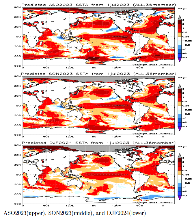
First, we take a look at the forecasted sea surface temperature anomalies (SSTA). JAMSTEC starts by forecasting the SSTA and Nino 3.4 Index on the first day of the month and from there it takes their models about two weeks to produce their seasonal forecast. I received it from JAMSTEC on July 13, 2023.
| This shows their forecast of sea surface temperature anomalies at three points in time. Notice the water along the Equator in the Pacific. Blue is cool (as an anomaly) and is associated with La Nina. Red is warm and is associated with El Nino. You can see the El Nino in all three time periods. It seems to be stronger in the 1st and 2nd time periods. The warmest water shifts west in the third period exhibiting Modoki characteristics. [I have similar information on their SSTA projections from NOAA but I usually do not include it in the article I write on the NOAA Seasonal Outlook because they do not seem to focus on it and their information does not extend as far into the future as does the information from JAMSTEC]. It is hard to find any blue in this set of forecasts. JAMSTEC uses the same definition of Normal (climatology as NOAA). They do a better job at characterizing La Ninas and El Ninos than NOAA. JAMSTEC provides me with a lot of other information that I do not include in my articles to keep them to a manageable size for readers. |
Then we look at three seasonal forecasts. JAMSTEC works with meteorological seasons and this month it does not line up perfectly. This means we do not have three full seasons of forecasts this month because the first three-month period overlaps the second one. JJA is meteorological summer and ASO is one month of summer and two months of autumn.
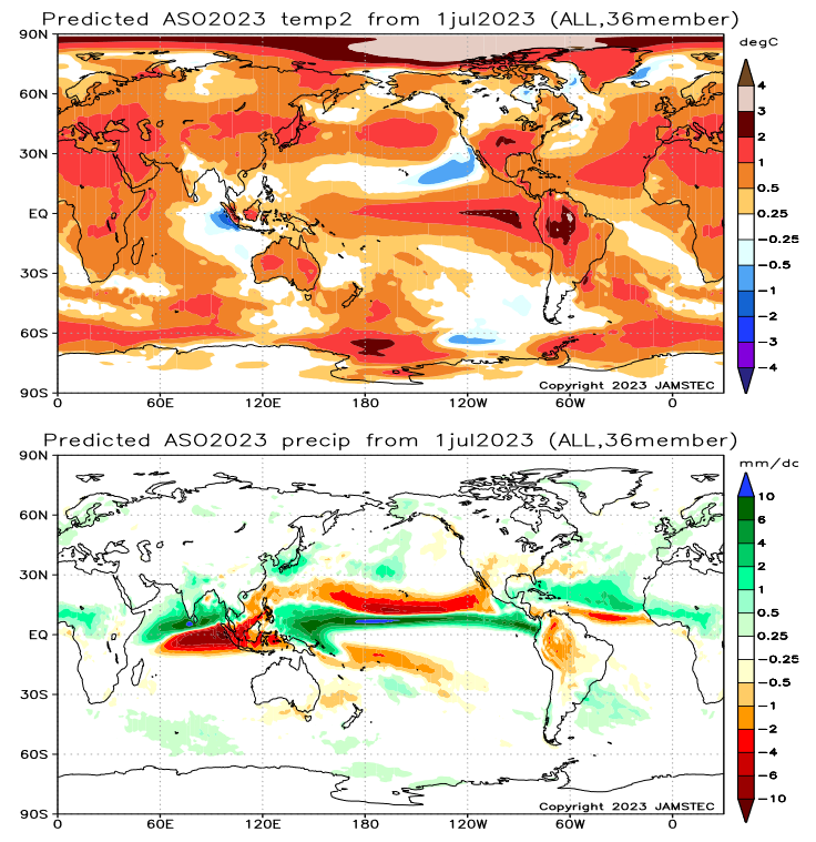
| The above covers August/September/October (ASO 2023).
Here is the interpretation from the JAMSTEC Discussion shown below: “The SINTEX-F predicts that most parts of the globe will experience a hotter-than-normal condition in the August–October average. The Arctic region will experience extremely hotter-than-normal conditions..” “As regards the rainfall in the August–October average, a drier-than-normal condition is predicted for the southern U.S.A., Hawaii, the northern part of the South American continent, eastern Australia, Indonesia, some parts of Indochina, the Philippines, and Taiwan. In contrast, Alaska, Mexico, the Caribbean, La Plata, India, Sri Lanka, Nepal, Bhutan, central and western Africa, some parts of coastal Indochina, some parts of East Asia, and some parts of western/northern Europe will experience a wetter-than-normal condition. In particular, we notice that Indonesia and eastern Australia may experience extremely drier than normal conditions, owing to a combination of the positive Indian Ocean Dipole and the El Niño.” “The model predicts that most of Japan will be hotter and wetter than normal in the August–October average and the autumn.” |
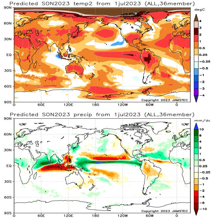
| The above covers September/October/November (SON 2023) which is meteorological Fall.
Here is the interpretation from the JAMSTEC Discussion shown below: “In the boreal autumn (austral spring), the model also predicts a similar condition as shown above for ASO. ” “In the boreal autumn (austral spring), a drier-than-normal condition is predicted for southwestern parts of the U.S.A., Hawaii, Mexico, many parts of the South American continent, eastern Australia, Indonesia, and the Philippines. In contrast, Alaska, Central America, some parts of La Plata, the Horn of Africa, some parts of central and western Africa, some parts of Europe, India, Sri Lanka, Nepal, Bhutan, and some parts of coastal Indochina will experience a wetter-than-normal condition.” “The model predicts that most of Japan will be hotter and wetter than normal in the August–October average and the autumn.” |
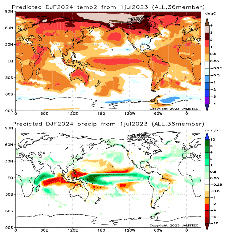
| And above, December/January/February (DJF) 2023/2024 is meteorological Winter. JAMSTEC does not provide its interpretation of its third season but one can observe it on the maps. |
Now I am going to provide their single-month forecasts for August, September, and October.
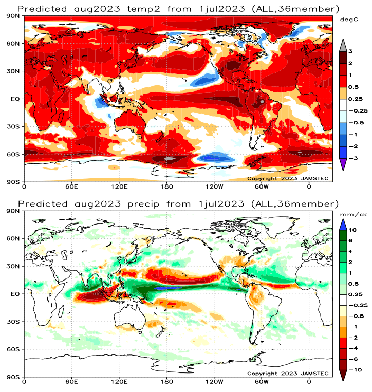
| The above is the single month of August 2023 |
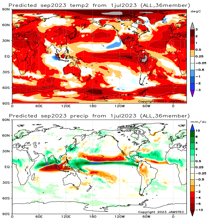
| The above is the single month of September 2023 |
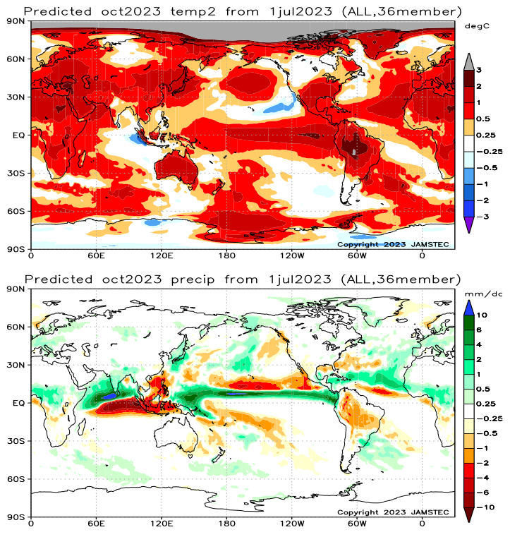
| The above is the single month of October 2023 |
Now we look at the key indices used by JAMSTEC in making their forecast. Perhaps I should have presented these first.
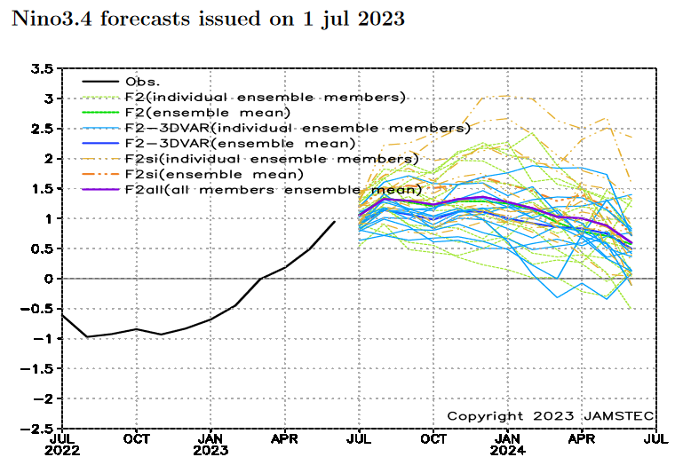
| This forecast is for a moderate strength El Nino (Nino 3.4 greater than 1). Many others are forecasting a stronger El Nino. |
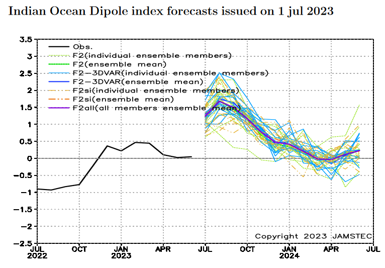
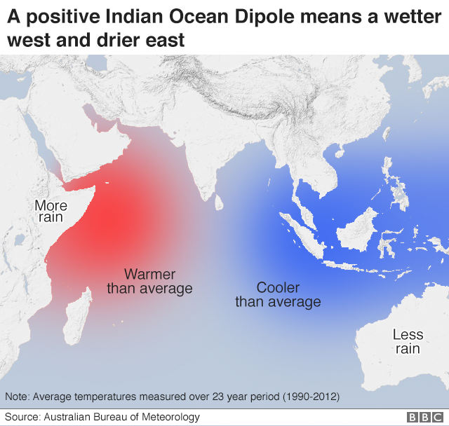
| We are having a Positive IOD. Below is shown the typical impact of a positive IOD. But the impacts can be complex. |
And here is the short JAMSTEC Discussion
ENSO forecast:
As predicted, the recent observation confirms the development of the El Niño. The SINTEX-F ensemble mean predicts that the El Niño will reach the peak in August and persist at least until the next boreal spring. However, there is a large uncertainty in the predicted amplitude.
Indian Ocean forecast:
The SINTEX-F continues to predict the occurrence of a positive Indian Ocean Dipole event during the boreal summer, although the signal is not yet clear from the observations.
Regional forecast:
The SINTEX-F predicts that most parts of the globe will experience a hotter-than-normal condition in the August–October average. In the boreal autumn (austral spring), the model also predicts a similar condition. The Arctic region will experience extremely hotter-than-normal conditions.
As regards the rainfall in the August–October average, a drier-than-normal condition is predicted for the southern U.S.A., Hawaii, the northern part of the South American continent, eastern Australia, Indonesia, some parts of Indochina, the Philippines, and Taiwan. In contrast, Alaska, Mexico, the Caribbean, La Plata, India, Sri Lanka, Nepal, Bhutan, central and western Africa, some parts of coastal Indochina, some parts of East Asia, and some parts of western/northern Europe will experience a wetter-than-normal condition. In particular, we notice that Indonesia and eastern Australia may experience extremely drier than normal conditions, owing to a combination of the positive Indian Ocean Dipole and the El Niño. In the boreal autumn (austral spring), a drier-than-normal condition is predicted for southwestern parts of the U.S.A., Hawaii, Mexico, many parts of the South American continent, eastern Australia, Indonesia, and the Philippines. In contrast, Alaska, Central America, some parts of La Plata, the Horn of Africa, some parts of central and western Africa, some parts of Europe, India, Sri Lanka, Nepal, Bhutan, and some parts of coastal Indochina will experience a wetter-than-normal condition.
The model predicts that most of Japan will be hotter and wetter than normal in the August–October average and the autumn.
–
| I hope you found this article interesting and useful |