Updated at 6:46 p.m. EDT Friday May 26, 2023
Here is what we are paying attention to in the next 48 to 72 hours. The article also includes weather maps for longer-term outlooks and a five-day World weather forecast.
We start with the U.S. Information.
Short Range Forecast Discussion
NWS Weather Prediction Center College Park MD
216 PM EDT Fri May 26 2023Valid 00Z Sat May 27 2023 – 00Z Mon May 29 2023
…A low pressure system is forecast to bring areas of heavy rain, gusty
winds and hazardous beach and boating conditions for the Southeast over
the Memorial Day weekend……Showers and thunderstorms expected to linger across the Great Basin,
northern and central Rockies, and the High Plains for the next few days……Warmer than normal across much of the Northwest and north-central U.S.
but much cooler than normal across the Mid-Atlantic and Southeast…

| Information Note: This article is now set up so that all the maps should automatically update. The links are provided but should not be needed. The downside is that if you go back to a previous version the maps will have been updated and not be relevant to the date of the prior article but will be current information. The NWS twice-a-day 48-hour forecasts do not auto-update in this article. I do it and I can be late doing it. The link for the NWS updates is HERE. Most of our other articles will not be set up to auto-update so that prior versions of the article will be meaningful.
Recently, we published the NOAA ENSO Update. You can access it HERE. It announces the coming of a full El Nino. There remain questions about how strong it will be. Remember the easiest way to get back to the article you were reading is to hit the return arrow in the upper left of your screen. There are other ways. |
First, the 48-Hour Forecast (It is a 48 to 72 Hour Forecast actually)
Daily weather maps. The Day 1 map updates twice a day and the Day 2 and 3 maps update only once a day. These maps update automatically. But if that does not happen, you can get updates by clicking HERE
TODAY (or late in the day the evening/overnight map will appear)
TOMORROW
NEXT DAY
This animation shows how things may play out over the next 60 hours. To update click here.
ATMOSPHERIC RIVERS
This tells us what is approaching the West Coast. Click HERE to update If I have not gotten around to doing the update. Here is some useful information about Atmospheric Rivers.
Continuation of the NWS Short Range Forecast. It is updated by NWS twice a day and these updates can be found here. We post at least one of those updates daily, sometimes both. The Highlights are shown in the lede paragraph of this article.
A very slow blocky upper level pattern is forecast to persist across the
continental U.S. through the Memorial Day weekend. An elongated north to
south trough of low pressure will exist in the west, but embedded stronger
jet streaks will help to produce surges of dry air out of the Southwest
while drawing above normal moisture up through the length of the High
Plains on Friday evening. This will trigger showers and thunderstorms
across the Great Basin into the Northern Rockies of Montana; while strong
to severe thunderstorms are expected to develop from southeast Montana
trough the Western Panhandle of Texas. The Storm Prediction Center has
issued a Slight Risk from MT through eastern WY and eastern CO, with a
risk of severe winds and hail being the highest potential. Further south
across southeast NM into West Texas Panhandle, an Enhanced Risk of severe
weather exists, with a better potential for tornadoes as well as severe
hail/winds. By Saturday, the risk is more limited in coverage and
intensity though should span the length the High Plains again, with the
best potential within a Slight Risk across Eastern WY into SDak/W Neb.
Some of these thunderstorms will be slow moving and have the potential for
very high rainfall rates. As such, the Weather Prediction Center has a
Slight Risk of Excessive Rainfall for Friday over much of E MT, parts of
northeast WY and portions of eastern New Mexico into the Cap Rock on
Friday and eastern MT on Saturday with broad Marginal Risk in connecting
areas through the length of the High Plains and Northern Rockies on both
days.Meanwhile, a low pressure system that has been developing over Florida
will bring deteriorating weather across the Southeast for the Memorial Day
weekend. This system will have a chance to gather some strength over the
warm waters off Florida and Georgia as it heads north toward the Carolinas
on Saturday before moving west into the Carolinas by Sunday morning.
Strong winds and anomalous moisture will help to strengthen the low,
generating high waves making for beach and boating activities to be quite
hazardous. High Surf Advisories have been posted for portions of Georgia
and South Carolina coasts already, life threatening rip currents are to be
expected for much of the Southeast. Boating conditions will also be quiet
treacherous with a Storm Warning issued by the Ocean Prediction Center/NWS
Forecast Office in Charleston and parts of SC offshore waters with a broad
Gale Warning up through the Florida East Coast to southeast VA/North
Carolina waters. Onshore conditions will not be much fun as well, strong
showers and thunderstorms should be numerous with high rainfall potential.
A Moderate Risk of Excessive Rainfall has been issued by WPC for parts of
the SC/NC Coastal Plain for Saturday, while a broader Slight Risk extends
across much of the Carolinas, so instances of flash flooding will be
possible. The areal coverage of showers/thunderstorms will result in a
very cloudy day on Saturday, with numerous record low Maximum temperatures
expected with highs in the 50s in the upstate SC and parts of NC and only
60s in the Low Country, generally 20 to 30 degrees below average.Elsewhere, across the Mississippi Valley, Great Lakes, Northeast and
Southwest should have a very pleasant weekend. Temperatures will be
average for much of the southern portion of the central U.S.; though the
northern tier, particularly the Plains and Upper Great Lakes will see
above normal but not oppressive temperatures in the 70s and 80s for both
Friday through Sunday.
Below is the current five-day cumulative forecast of precipitation (Updates can be found HERE)
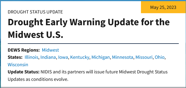
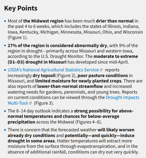
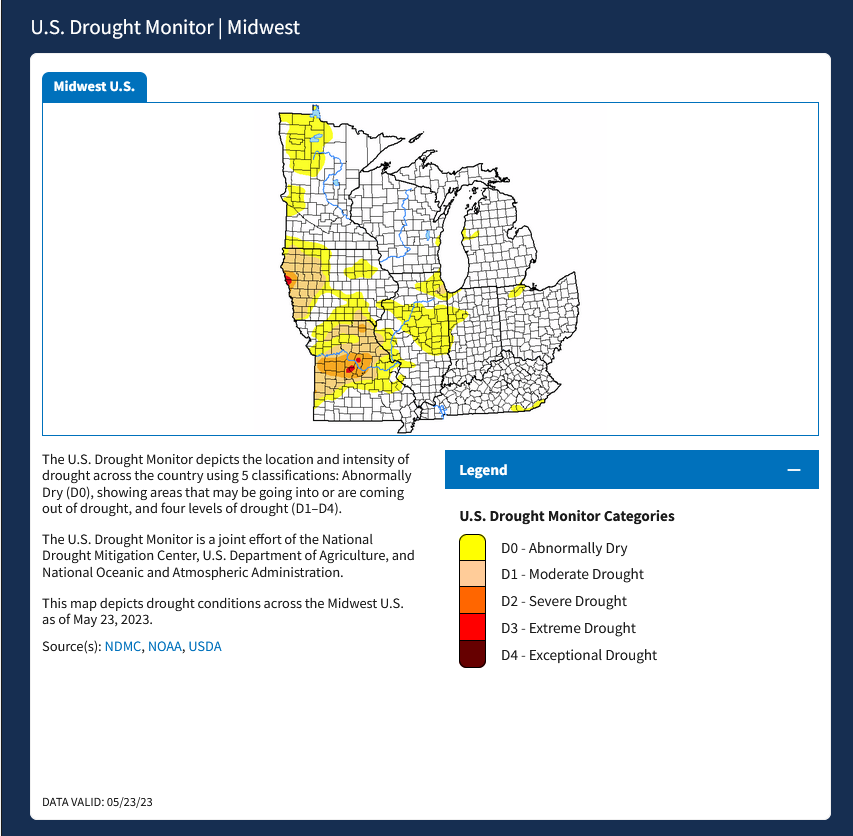
New Drought Warning
Now we look at Intermediate-Term “Outlook” maps for three time periods. Days 6 – 10, Days 8 – 14, and Weeks 3 and 4. An outlook differs from a forecast based on how NOAA uses these terms in that an “outlook” presents information as deviation from normal and the likelihood of these deviations.
Below are the links to obtain updates and additional information. They are particularly useful if you happen to be reading this article significantly later than when it was published. I always try to provide readers with the source of the information in my articles.
Days 6 – 10 (shown in Row 1) Days 8 – 14 (Shown in Row 2) Weeks 3 and 4 (Shown in Row 3 but updates only on Fridays) https://www.cpc.ncep.noaa. gov/products/predictions/610day/ https://www.cpc.ncep .noaa.gov/products/predictions/814day/ https://www.cpc.ncep.noaa.gov/products/predictions/WK34/ Showing the actual maps. They should now update automatically. The Week 3 – 4 Outlook only updates on Fridays. So below is what I call the Intermediate-term outlook. On Fridays, it extends out 28 Days. That declines day by day so on Thursday it only looks out 22 days until the next day when the Week 3 – 4 Outlook is updated and this extends the outlook by one additional week.
6 –
10
8 –
14
3 –
4
HAZARDS OUTLOOKS
Click here for the latest complete Day 3 -7 Hazards forecast which updates only on weekdays. Once a week probably Monday or Tuesday I will update the images. I provided the link for readers to get daily updates on weekdays. Use your own judgment to decide if you need to update these images. I update almost all the images Friday Night for the weekend edition of this Weather Report. So normally readers do not need to update these images but if the weather is changing quickly you may want to.
Temperature month to date can be found at https://hprcc.unl.edu/products/maps/acis/MonthTDeptUS.png
Precipitation month to date can be found at https://hprcc.unl.edu/products/maps/acis /MonthPNormUS.png
World Forecast
Below are the Day 1 -3 and 4-6 forecasts for temperature and precipitation. Updates and much additional information can be obtained HERE
World Temperature Anomalies
World Accumulated Precipitation
This information is provided by the University of Maine. They draw upon many different sources. There is a lot of information available at the link provided. I have just provided two useful forecasts. There are probably over a hundred different forecasts available from this source.
Worldwide Tropical Forecast (This is a NOAA Product)
This graphic updates on Tuesdays) If it has not been updated, you can get the update by clicking here Readers will only have to do that if they are reading this article much later than the date of it being published.
–
I hope you found this article interesting and useful. –


