Updated at 11:18 p.m. EDT Thursday, May 25, 2023, to provide information on the new drought warning for the Midwest.
Here is what we are paying attention to in the next 48 to 72 hours. The article also includes weather maps for longer-term outlooks and a five-day World weather forecast.
We start with the U.S. Information.
Short Range Forecast Discussion
NWS Weather Prediction Center College Park MD
339 PM EDT Thu May 25 2023Valid 00Z Fri May 26 2023 – 00Z Sun May 28 2023
…Locally heavy rain and thunderstorms possible in the Southeast, Great
Basin, northern Rockies, and High Plains over the next few days……Hazardous beach conditions in the Southeast this weekend…
…Above average temps in the Northwest and North-Central U.S. and below
average temps in the Mid-Atlantic and Southeast through the weekend…
![]()
| Information Note: This article is now set up so that all the maps should automatically update. The links are provided but should not be needed. The downside is that if you go back to a previous version the maps will have been updated and not be relevant to the date of the prior article but will be current information. The NWS twice-a-day 48-hour forecasts do not auto-update in this article. I do it and I can be late doing it. The link for the NWS updates is HERE. Most of our other articles will not be set up to auto-update so that prior versions of the article will be meaningful.
Recently, we published the NOAA ENSO Update. You can access it HERE. It announces the coming of a full El Nino. There remain questions about how strong it will be. Remember the easiest way to get back to the article you were reading is to hit the return arrow in the upper left of your screen. There are other ways. |
First, the 48-Hour Forecast (It is a 48 to 72 Hour Forecast actually)
Daily weather maps. The Day 1 map updates twice a day and the Day 2 and 3 maps update only once a day. These maps update automatically. But if that does not happen, you can get updates by clicking HERE
TODAY (or late in the day the evening/overnight map will appear)
TOMORROW
NEXT DAY
This animation shows how things may play out over the next 60 hours. To update click here.
ATMOSPHERIC RIVERS
This tells us what is approaching the West Coast. Click HERE to update If I have not gotten around to doing the update. Here is some useful information about Atmospheric Rivers.
Continuation of the NWS Short Range Forecast. It is updated by NWS twice a day and these updates can be found here. We post at least one of those updates daily, sometimes both. The Highlights are shown in the lede paragraph of this article.
A slow and weak upper level pattern will result in a fairly stagnant
weather pattern across the lower 48 states through the weekend. A couple
upper level troughs will impact the West and Southeast during the period,
which will change up the pattern slightly.The first upper trough will move very slowly across the West over the next
few days. This feature will be fairly weak, but will produce shower and
thunderstorm chances each day for much of the Great Basin and northern
Rockies. Locally heavy rainfall will be possible with slow-moving storms,
and isolated to scattered instances of flash flooding will be possible.Shower and thunderstorm chances will also prevail each day over parts of
the High Plains due to persistent troughing and enhanced convergence in
this region. Locally heavy rainfall may lead to isolated to scattered
instances of flash flooding. Isolated to scattered severe thunderstorms
will also be possible, and the Storm Prediction Center has a Marginal Risk
of Severe Thunderstorms (level 1/5) over the entire region for Friday and
Saturday with smaller embedded Slight Risk areas (level 2/5) for Friday.The second upper trough will bring a surface low towards the Southeast
coast over the weekend. This feature will approach the coast very slowly,
resulting in a prolonged period of less than ideal holiday weekend
conditions. Shower and thunderstorm chances will increase along the coast
and over Florida on Friday, then shift north into the Carolinas and
southern Mid-Atlantic Saturday into Sunday. The heaviest rain is expected
in the Carolinas over the weekend, and scattered instances of flash
flooding will be possible. Beach conditions along the Southeastern coast
will be hazardous through the weekend with gusty winds and frequent rip
currents possible.Temperatures will trend above average for the majority of the Northwest
and North-Central U.S. with highs in the 70s and 80s. Above average
temperatures will expand into the Northeast Saturday and Sunday as a warm
front lifts north of the region, and highs will reach into the 80s by
Sunday. Forecast cloud cover and precipitation will result in below normal
temperatures in the Southeast and southern Mid-Atlantic region through the
weekend with highs only reaching the 60s and lower 70s.
Below is the current five-day cumulative forecast of precipitation (Updates can be found HERE)
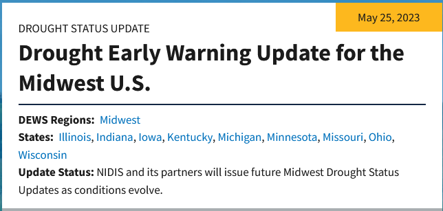
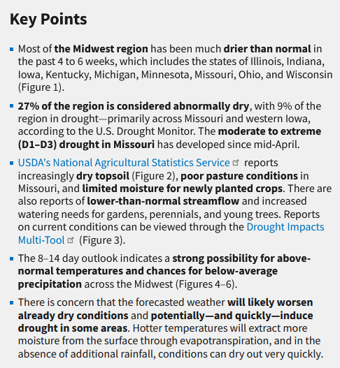
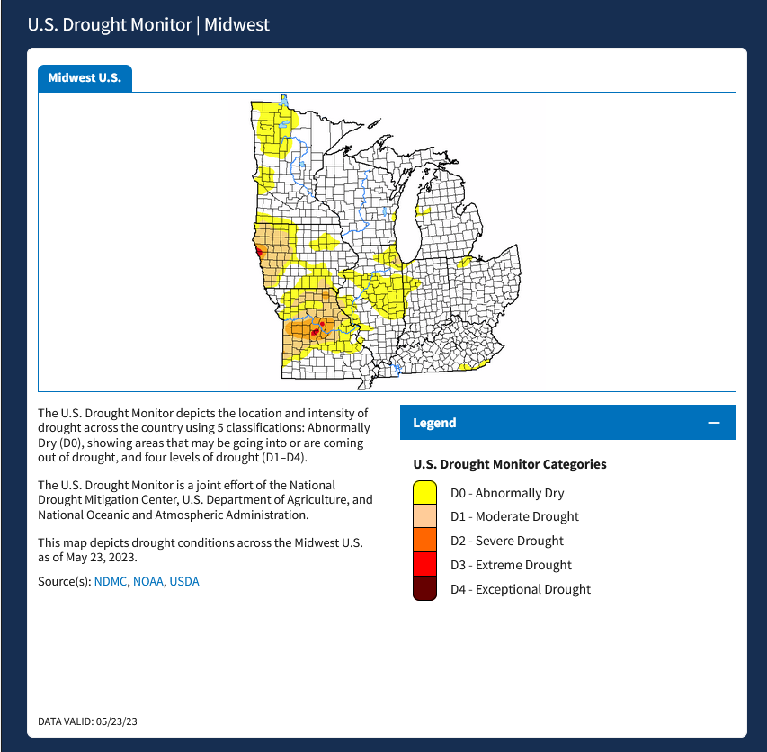
New Drought Warning
Now we look at Intermediate-Term “Outlook” maps for three time periods. Days 6 – 10, Days 8 – 14, and Weeks 3 and 4. An outlook differs from a forecast based on how NOAA uses these terms in that an “outlook” presents information as deviation from normal and the likelihood of these deviations.
Below are the links to obtain updates and additional information. They are particularly useful if you happen to be reading this article significantly later than when it was published. I always try to provide readers with the source of the information in my articles.
Days 6 – 10 (shown in Row 1) Days 8 – 14 (Shown in Row 2) Weeks 3 and 4 (Shown in Row 3 but updates only on Fridays) https://www.cpc.ncep.noaa. gov/products/predictions/610day/ https://www.cpc.ncep .noaa.gov/products/predictions/814day/ https://www.cpc.ncep.noaa.gov/products/predictions/WK34/ Showing the actual maps. They should now update automatically. The Week 3 – 4 Outlook only updates on Fridays. So below is what I call the Intermediate-term outlook. On Fridays, it extends out 28 Days. That declines day by day so on Thursday it only looks out 22 days until the next day when the Week 3 – 4 Outlook is updated and this extends the outlook by one additional week.
6 –
10
8 –
14
3 –
4
HAZARDS OUTLOOKS
Click here for the latest complete Day 3 -7 Hazards forecast which updates only on weekdays. Once a week probably Monday or Tuesday I will update the images. I provided the link for readers to get daily updates on weekdays. Use your own judgment to decide if you need to update these images. I update almost all the images Friday Night for the weekend edition of this Weather Report. So normally readers do not need to update these images but if the weather is changing quickly you may want to.
Temperature month to date can be found at https://hprcc.unl.edu/products/maps/acis/MonthTDeptUS.png
Precipitation month to date can be found at https://hprcc.unl.edu/products/maps/acis /MonthPNormUS.png
World Forecast
Below are the Day 1 -3 and 4-6 forecasts for temperature and precipitation. Updates and much additional information can be obtained HERE
World Temperature Anomalies
World Accumulated Precipitation
This information is provided by the University of Maine. They draw upon many different sources. There is a lot of information available at the link provided. I have just provided two useful forecasts. There are probably over a hundred different forecasts available from this source.
Worldwide Tropical Forecast (This is a NOAA Product)
This graphic updates on Tuesdays) If it has not been updated, you can get the update by clicking here Readers will only have to do that if they are reading this article much later than the date of it being published.
–
I hope you found this article interesting and useful. –