Updated at 2:42 p.m. EST Friday, February 17, 2023 to incorporate information on the latest Sudden Stratospheric Warming (SSW) event. Updated at 3:34 p.m. EST Friday 17, 2023 to incorporate the afternoon NWS forecast.
Here is what we are paying attention to in the next 48 to 72 hours. The article also includes weather maps for longer-term outlooks and a five-day World weather forecast.
We start with the U.S. Information.
Short Range Forecast Discussion
NWS Weather Prediction Center College Park MD
227 PM EST Fri Feb 17 2023Valid 00Z Sat Feb 18 2023 – 00Z Mon Feb 20 2023
…Locally heavy snow to spread across the high terrain of the Northern
Rockies and Northwest…
![]()
| Information Note: This article is now set up so that all the maps should automatically update. The links are provided but should not be needed. The downside is that if you go back to a previous version the maps will have been updated and not be relevant to the date of the prior article but will be current information. The NWS twice-a-day 48-hour forecasts do not auto-update in this article. I do it and I can be late doing it. The link for the NWS updates is HERE. Most of our other articles will not be set up to auto-update so that prior versions of the article will be meaningful.
To read the new NOAA Four-Season Outlook Click HERE . Remember the easiest way to get back to the article you were reading is to hit the return arrow in the upper left of your screen. There are other ways. |
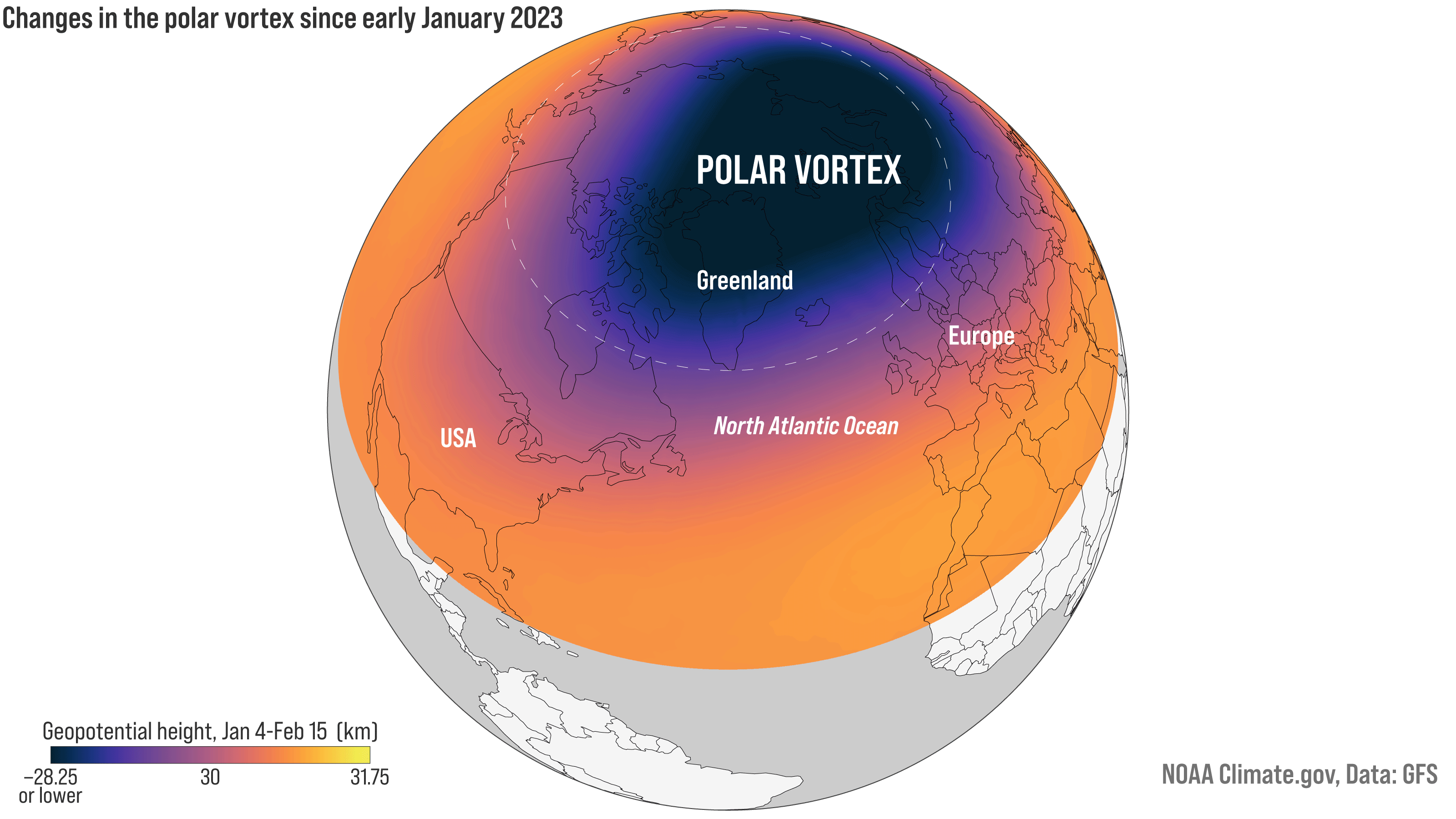
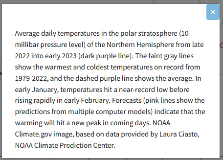
| It is mentioned in the NOAA Seasonal Outlook Discussion issued on February 16. But they were not very definitive about the impact of yet another Sudden Stratospheric Warming (SSW) event probably because it is hard to forecast the impact of these events on the ground. But HERE is a link to an article on this evolving event. One of the images below shows better in that article than when republished in our article, so if you want to see the fainter lines in that graphic, go to the link provided. The exact timing of the impacts at surface level is not clear at this time. A warming event in the stratosphere may or may not impact weather closer to the surface of the Earth. It usually does but where and when are difficult to predict. |

Now, the 48-Hour Forecast (It is a 48 to 72 Hour Forecast actually)
Daily weather maps. I try to keep the below three maps updated. The Day 1 map updates twice a day and the Day 2 and 3 maps update only once a day. I will be doing the updating during the period described in the title of the article but if you happen to read this article later, you can get updates by clicking HERE
TODAY (or late in the day the evening/overnight map will appear)
TOMORROW
NEXT DAY
This animation shows how things may play out over the next 60 hours. To update click here.
ATMOSPHERIC RIVERS
This tells us what is approaching the West Coast. Click HERE to update If I have not gotten around to doing the update. Here is some useful information about Atmospheric Rivers.
Continuation of the NWS Short Range Forecast (It is updated by NWS twice a day and these updates can be found here. We post at least one of those updates daily, sometimes both. The Highlights are shown in the lede paragraph of this article.
The most notable precipitation forecast across the Nation through this
weekend is expected to occur over the Pacific Northwest and Northern
Rockies in the form of potentially heavy mountain snow. Northwesterly flow
aloft around an eastern Pacific upper-level ridge will allow for waves of
of moisture to enter the region. Snow is expected to be heaviest across
the higher terrain and gradually add up to over a foot by the end of the
weekend. Lower elevations across Idaho and western Montana may also
experience lighter snowfall amounts.Elsewhere, a much colder airmass has entered the eastern third of the
Nation today behind a potent cold front. Lingering snow showers are not
out of the question across southern New England this evening as
subfreezing air surges southeastward. Lake effect snow showers are also
expected to linger into early Saturday, along with upslope snow throughout
the central Appalachians. Farther south, scattered showers along the cold
front are forecast to swing southward across the Florida Peninsula into
Saturday. Easterly flow will continue across the Sunshine State this
weekend and allow for isolated shower chances. Lastly, in terms of
precipitation, light snow may traverse the northern Plains and Upper
Midwest on Sunday, while shower chances enter Arizona and New Mexico ahead
of a churning upper-level low.Temperatures this weekend are not anticipated to be widely anomalous
compared to climatological averages. Below average temperatures are
forecast across the southern tier on Saturday underneath a modest high
pressure system. Above average temperatures then become more widespread on
Sunday (outside the Rockies and Intermountain West).
Below is the current five-day cumulative forecast of precipitation (Updates can be found HERE)
Now we look at Intermediate-Term “Outlook” maps for three time periods. Days 6 – 10, Days 8 – 14, and Weeks 3 and 4. An outlook differs from a forecast based on how NOAA uses these terms in that an “outlook” presents information as deviation from normal and the likelihood of these deviations.
Below are the links to obtain updates and additional information. They are particularly useful if you happen to be reading this article significantly later than when it was published. I always try to provide readers with the source of the information in my articles.
| Days 6 – 10 (shown in Row 1) | Days 8 – 14 (Shown in Row 2) | Weeks 3 and 4 (Shown in Row 3 but updates only on Fridays) |
| https://www.cpc.ncep.noaa. gov/products/predictions/610day/ | https://www.cpc.ncep .noaa.gov/products/predictions/814day/ | https://www.cpc.ncep.noaa.gov/products/predictions/WK34/ |
Showing the actual maps. They should now update automatically. The Week 3 – 4 Outlook only updates on Fridays. So below is what I call the Intermediate-term outlook. On Fridays, it extends out 28 Days. That declines day by day so on Thursday it only looks out 22 days until the next day when the Week 3 – 4 Outlook is updated and this extends the outlook by one additional week.
| 6
– 10
|
|
|
| 8
– 14 |
|
|
| 3
– 4 |
|
|
HAZARDS OUTLOOKS
Click here for the latest complete Day 3 -7 Hazards forecast which updates only on weekdays. Once a week probably Monday or Tuesday I will update the images. I provided the link for readers to get daily updates on weekdays. Use your own judgment to decide if you need to update these images. I update almost all the images Friday Night for the weekend edition of this Weather Report. So normally readers do not need to update these images but if the weather is changing quickly you may want to.
Month to Date Information
Temperature month to date can be found at https://hprcc.unl.edu/products/maps/acis/MonthTDeptUS.png
Precipitation month to date can be found at https://hprcc.unl.edu/products/maps/acis /MonthPNormUS.png
World Forecast
Below are the 5-Day forecasts for temperature and precipitation. Updates and much additional information can be obtained HERE
This information is provided by the University of Maine. They draw upon many different sources. There is a lot of information available at the link provided. I have just provided two useful forecasts. There are probably over a hundred different forecasts available from this source.
Worldwide Tropical Forecast (This is a NOAA Product)
This graphic updates on Tuesdays) If it has not been updated, you can get the update by clicking here Readers will only have to do that if they are reading this article much later than the date of it being published.-
–
| I hope you found this article interesting and useful. |