Updated at 4:03 p.m. Tuesday, January 31, 2023
Here is what we are paying attention to in the next 48 to 72 hours. This article also includes World weather forecasts.
It also includes links for longer-term outlooks and sometimes (like today) we show the maps that one finds if one clicks on those links. But we can not update all of those maps each day so look at the date and the duration of the period of time involved. If you want a more up-to-date map, click on the provided link which may be located in a table of links. If the date in the title of the article is not today’s date. just go to Econcurrents.com and look for today’s weather article.
We start with the U.S. Information.
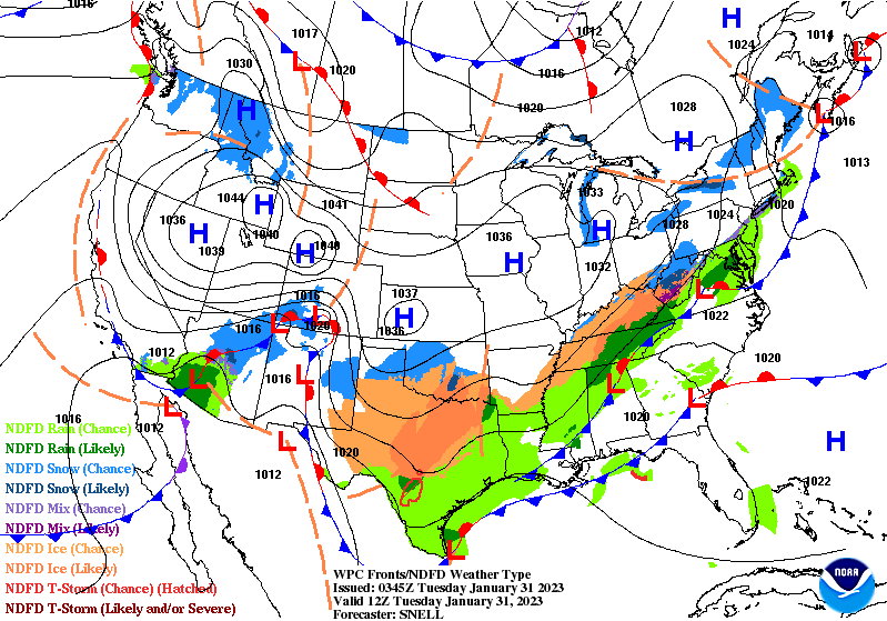
Short Range Forecast Discussion
NWS Weather Prediction Center College Park MD
300 PM EST Tue Jan 31 2023Valid 00Z Wed Feb 01 2023 – 00Z Fri Feb 03 2023
…Prolonged and significant ice storm to continue impacting a large area
from the southern Plains to the Tennessee Valley……Heavy rain and scattered flash floods possible across parts of the Deep
South and Southeast midweek……Unseasonably cold temperatures continue for portions of the South, with
another surge of arctic air for the Northern Tier Thursday…
![]()
First, the 48-Hour Forecast (It is a 48 to 72 Hour Forecast actually)
Daily weather maps. I try to keep the below three maps updated. The Day 1 map updates twice a day and the Day 2 and 3 maps update only once a day. I will be doing the updating during the period described in the title of the article but if you happen to read this article later, you can get updates by clicking HERE.
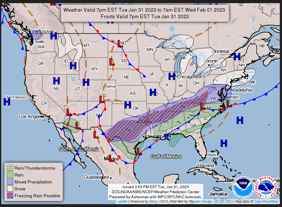
TUESDAY AFTERNOON, EVENING, AND EVENING
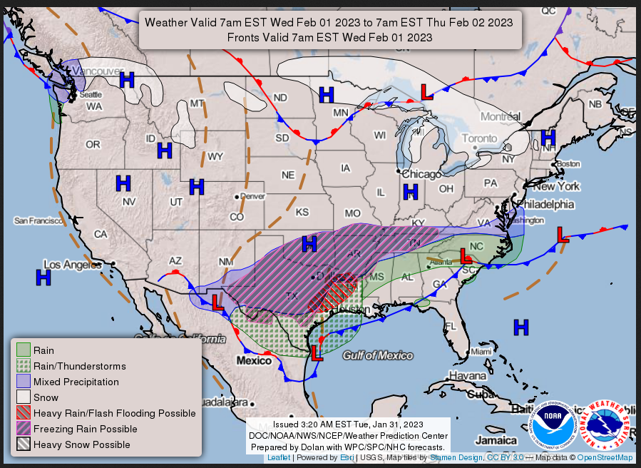
WEDNESDAY
THURSDAY
This animation shows how things may play out over the next 60 hours. To update click here.
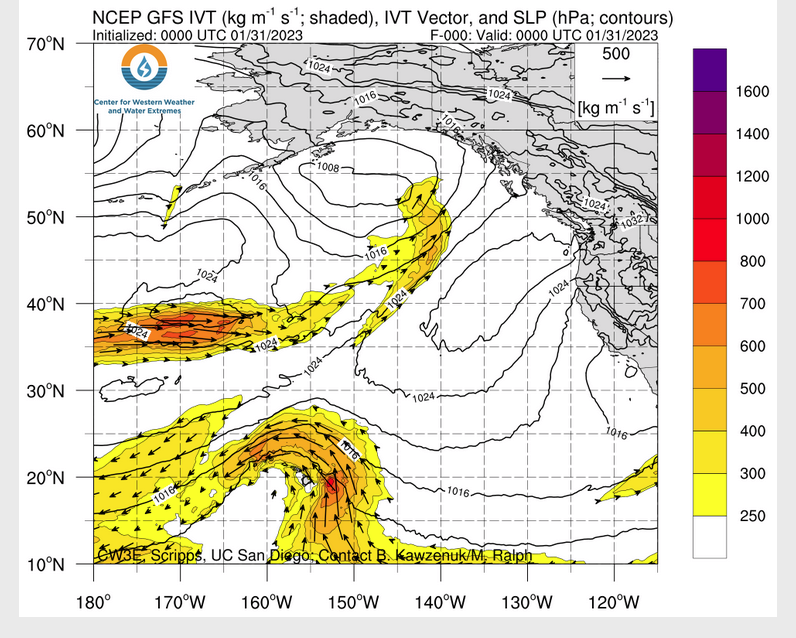
ATMOSPHERIC RIVERS
Continuation of the NWS Short Range Forecast (It is updated by NWS twice a day and these updates can be found here. We post at least one of those updates daily, sometimes both. The Highlights are shown in the lede paragraph of this article.
The major weather story over the next few days will continue to be the
ongoing ice storm affecting portions of the southern Plains and Mid-South.
In the wake of an arctic cold frontal passage, warm and moist air
overrunning cold air at the surface will lead to additional rounds of
wintry precipitation, with brief lulls followed by bursts of sleet and
freezing rain that could drastically deteriorate road conditions.
Widespread total ice accretion of greater than 0.25″ is likely from West
Texas to western Tennessee through Thursday morning, with localized areas
receiving as much as 0.75″. In addition to potentially hazardous travel
conditions, this amount of ice will likely lead to some tree damage and
scattered power outages across the hardest-hit regions. Sleet
accumulations around a half inch or locally higher are also possible from
West Texas to Arkansas, which will compound the risk for icy, dangerous
road conditions. As a result, Ice Storm Warnings, Winter Storm Warnings,
and Winter Weather Advisories continue for the region. Travelers are
advised to check road conditions before venturing out and drive with
extreme caution, with travel already slow-going and numerous roads closed,
particular for the Dallas/Fort-Worth and Austin metro areas.Along and just to the north of the aforementioned frontal boundary now
lingering along the Gulf Coast, numerous showers and thunderstorms are
forecast to develop and push eastward from eastern Texas beginning on
Wednesday. This final surge of moisture in tandem with a lifting
upper-level trough exiting northern Mexico may lead to a swath of 1-2″ of
rainfall from eastern Texas northeast through the southern Appalachians,
with locally higher amounts possible, particular across portions of
central Mississippi. Saturated soils throughout the region may exacerbate
the flash flooding concern, which has led to a Slight Risk (level 2/4) of
Excessive Rainfall on Wednesday and Thursday spanning from eastern Texas
to northwest Georgia, with the threat gradually sliding eastward each day.Forecast high temperatures Wednesday will generally be seasonable to below
average for most of the country, with some of the more unusually cold
temperatures continuing behind the front over the Southern Plains and
Mid-South. Highs will remain at or just above freezing on Wednesday before
warming up a bit into the 40s on Thursday. An upper-level wave over Canada
will push southeastward towards the northern tier of the U.S. late
Wednesday, helping to usher in another surge of cold, Canadian air
southward through the day Thursday. Highs in the teens and 20s for
portions of the Northern Plains and Upper Midwest on Wednesday will drop
into the single digits Thursday, with wind chills below zero likely.
Post-frontal flow over the Great Lakes following the cold front will lead
to some lake effect snow on Thursday. In contrast, much above normal
temperatures are forecast for portions of the coastal Southeast and the
Florida Peninsula, with highs in the 70s to low 80s.In the West, some snow showers will continue in the Northern Rockies
through Tuesday evening before tapering off by Wednesday Morning.
Additional accumulations should be limited to more isolated higher,
mountain locations. A storm system will approach the Pacific Northwest
during the day Thursday helping to increase the chance for some light
lower elevation/coastal rain and snow for the Cascades, with heavier
precipitation chances likely by Friday morning just beyond the current
forecast period. Another night of freezing temperatures are expected for
the Central Valley of California, with a frost possible for locations
around the Bay Area. Temperatures should begin to moderate during the day
Wednesday as an upper-level ridge moves over the region.
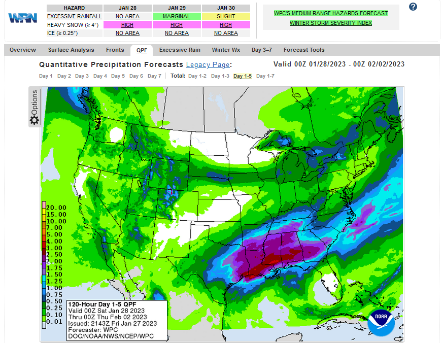
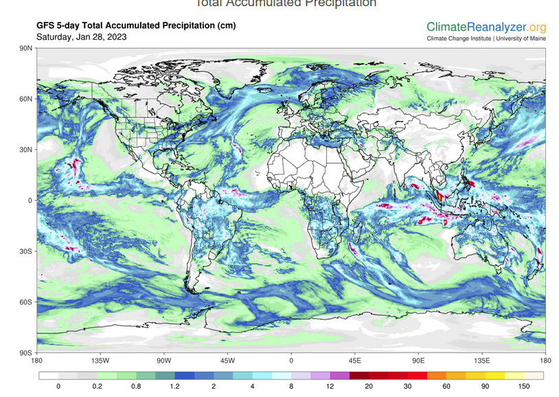
Below is the current five-day cumulative forecast of precipitation (Updates can be found HERE)
Now we look at Intermediate-Term “Outlook” maps for three time periods. Days 6 – 10, Days 8 – 14, and Weeks 3 and 4. An outlook differs from a forecast based on how NOAA uses these terms in that an “outlook” presents information as deviation from normal and the likelihood of these deviations.
Below are the links to obtain updates and additional information. They are particularly useful if you happen to be reading this article significantly later than when it was published. I always try to provide readers with the source of the information in my articles.
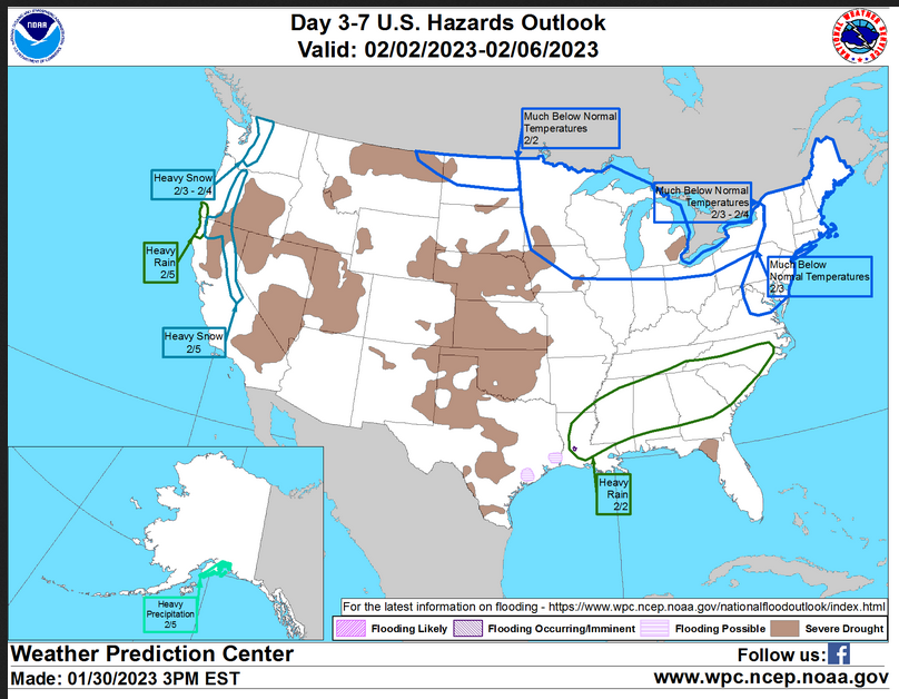
HAZARDS OUTLOOKS
Click here for the latest complete Day 3 -7 Hazards forecast which updates only on weekdays. Once a week probably Monday or Tuesday I will update the images. I provided the link for readers to get daily updates on weekdays. Use your own judgment to decide if you need to update these images. I update almost all the images Friday Night for the weekend edition of this Weather Report. So normally readers do not need to update these images but if the weather is changing quickly you may want to.
Month to Date Information
Temperature month to date can be found at https://hprcc.unl.edu/products/maps/acis/MonthTDeptUS.png
Precipitation month to date can be found at https://hprcc.unl.edu/products/maps/acis /MonthPNormUS.png
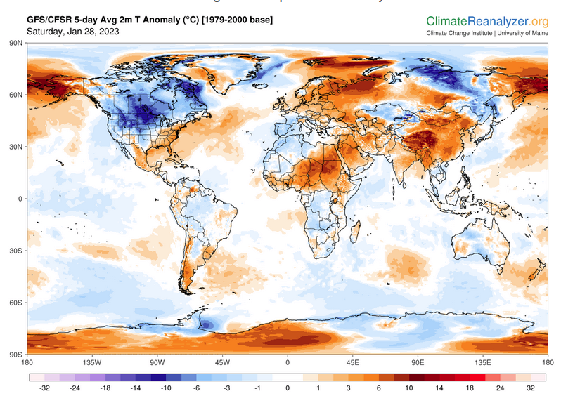
World Forecast
Below are the 5-Day forecasts for temperature and precipitation. Updates and much additional information can be obtained HERE
This information is provided by the University of Maine. They draw upon many different sources. There is a lot of information available at the link provided. I have just provided two useful forecasts. There are probably over a hundred different forecasts available from this source.
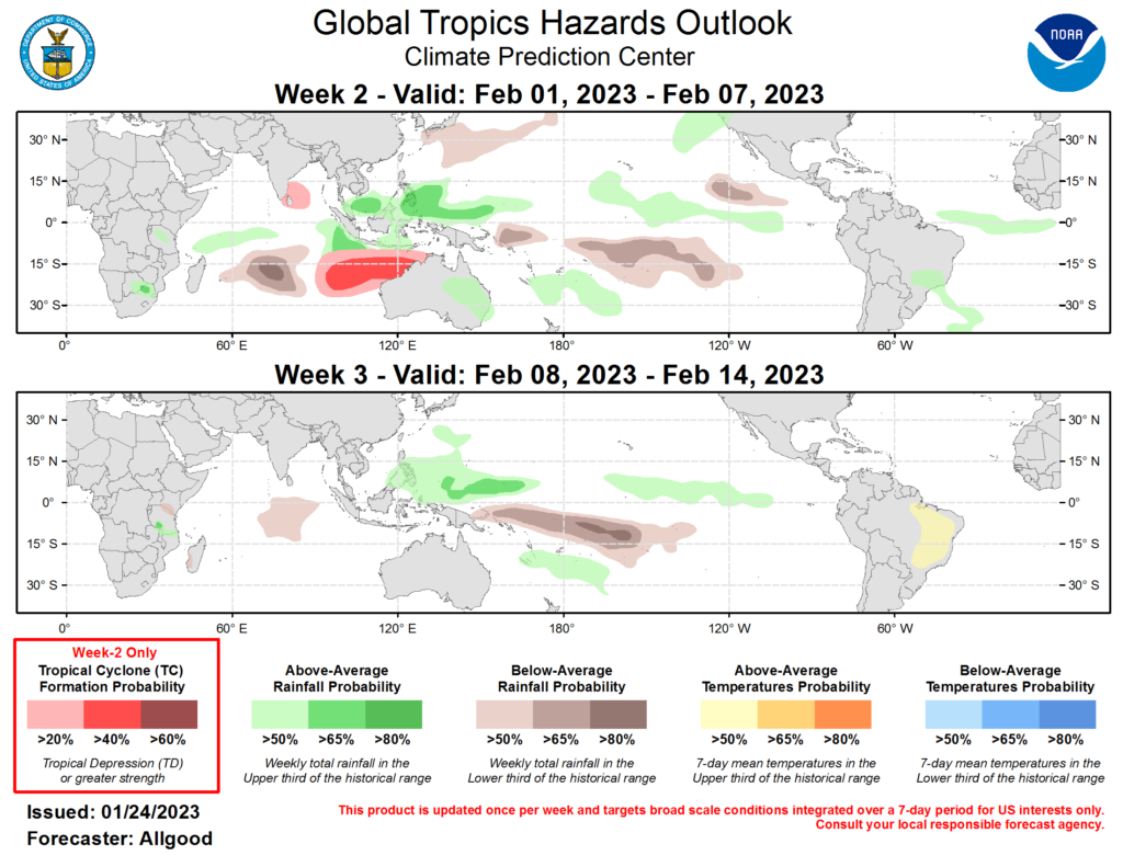
Worldwide Tropical Forecast (This is a NOAA Product)
This graphic updates on Tuesdays) If it has not been updated, you can get the update by clicking here Readers will only have to do that if they are reading this article much later than the date of it being published.-
| I hope you found this article interesting and useful. |