Updated at 3:40 p.m. EST Monday, January 23, 2023
Here is what we are paying attention to in the next 48 to 72 hours. This article also includes World weather forecasts.
It also includes links for longer-term outlooks and sometimes we show the maps that one finds if one clicks on those links. But we can not update all of those maps each day so look at the date and the duration of the period of time involved. If you want a more up-to-date map, click on the provided link which may be located in a table of links. If the date in the title of the article is not today’s date. just go to Econcurrents.com and look for today’s weather article.
We start with the U.S. Information.
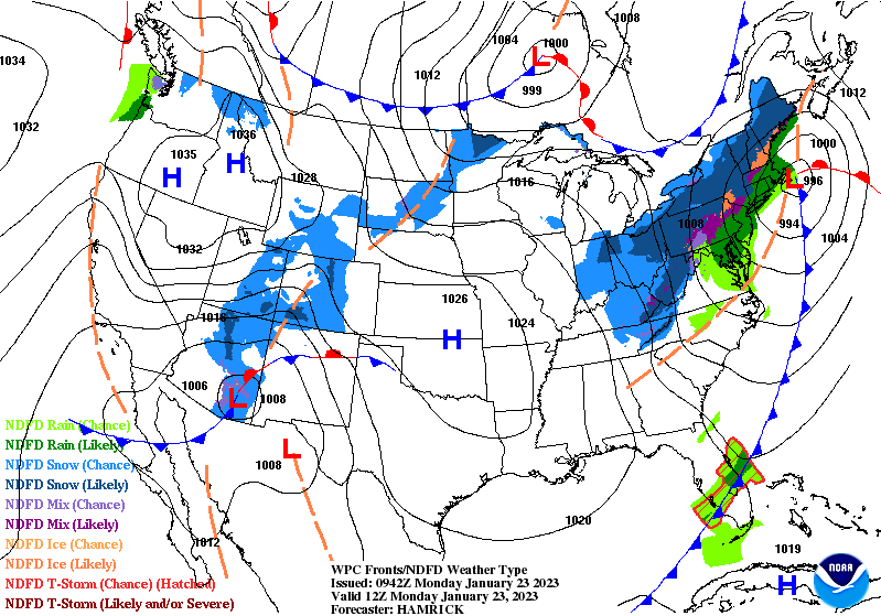
Short Range Forecast Discussion
NWS Weather Prediction Center College Park MD
200 PM EST Mon Jan 23 2023

Valid 00Z Tue Jan 24 2023 - 00Z Thu Jan 26 2023

...New storm system over the South expected to bring heavy snow to
portions of the southern High Plains, middle Mississippi Valley, Ohio
Valley, Great Lakes and Northeast through midweek...

...Strong to severe thunderstorms and a threat of flash flooding can be
expected across portions of the Gulf Coast states and lower Mississippi
Valley Tuesday through early Wednesday...
First, the 48-Hour Forecast (It is a 48 to 72 Hour Forecast actually)
Daily weather maps. I try to keep the below three maps updated. The Day 1 map updates twice a day and the Day 2 and 3 maps update only once a day. I will be doing the updating during the period described in the title of the article but if you happen to read this article later, you can get updates by clicking HERE.
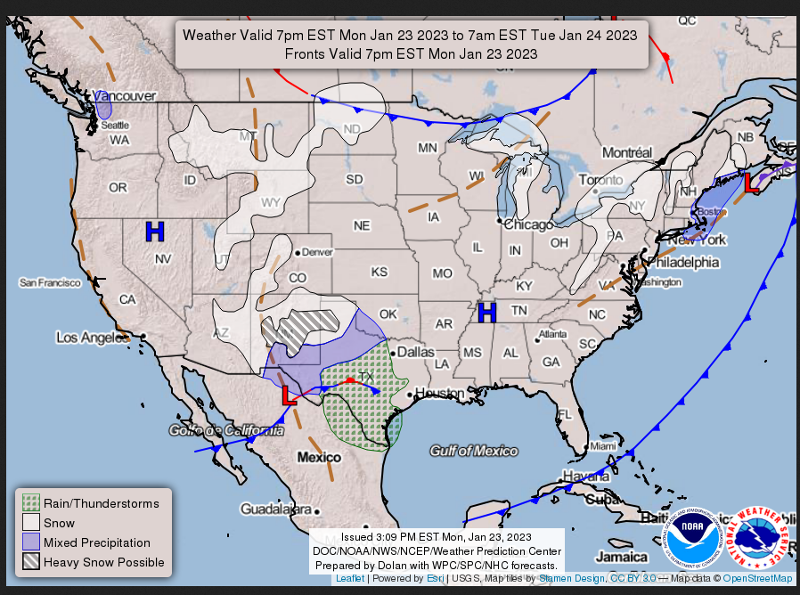
MONDAY AFTERNOON, EVENING AND OVERNIGHT
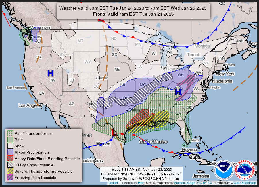
TUESDAY
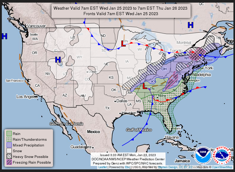
WEDNESDAY
This animation shows how things may play out over the next 60 hours. To update click here.
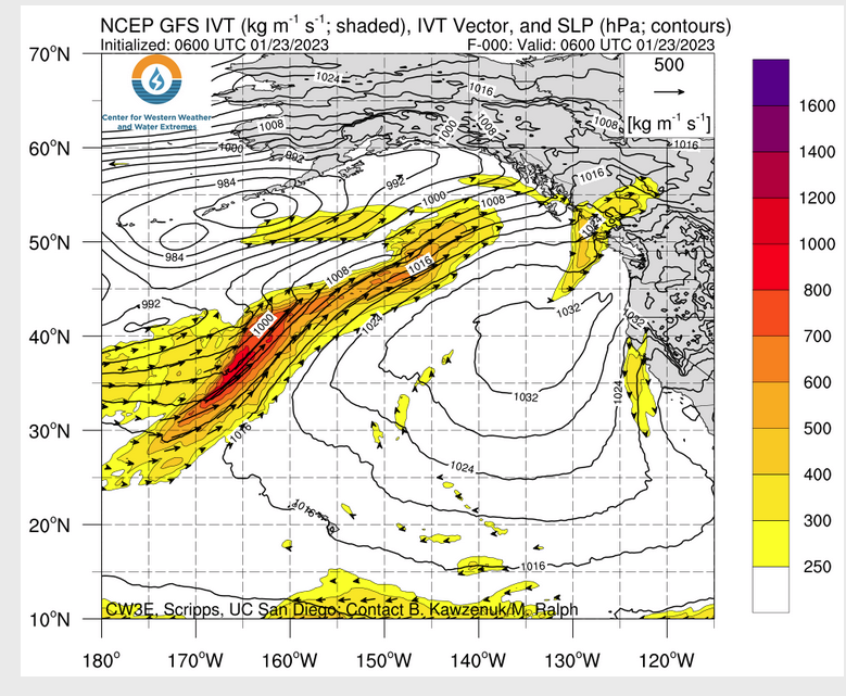
ATMOSPHERIC RIVERS
Continuation of the NWS Short Range Forecast (It is updated by NWS twice a day and these updates can be found here. We post at least one of those updates daily, sometimes both. The Highlights are shown in the lede paragraph of this article.
The weather pattern will be quite active across the central and eastern
U.S. going through the middle of the week, as a new storm system begins to
organize and strengthen across the South on Tuesday and then lifts
northeast across the Mid-South and into the Ohio Valley and Mid-Atlantic
states by Wednesday. This system will follow on the heels of a coastal low
still impacting the Northeast that will exit away from New England and
through the Canadian maritimes tonight. Some additional light snow may
impact portions of New England, and especially Downeast Maine tonight
where a couple inches of additional snow may accumulate before ending.
Colder, drier air and windy conditions will arrive across the Northeast on
Tuesday in the wake of this system.

However, attention will then quickly be focused on the new storm system
dropping down across the Four Corners region that will eject east and
begin to strengthen across the South on Tuesday. Low pressure is expected
to lift from far southeast Texas through the lower Mississippi Valley by
Tuesday night, and then across the Mid-South by early Wednesday. By
Wednesday night, deepening low pressure will cross the Ohio Valley as a
new low pressure system develops over the Mid-Atlantic states. This
evolving storm track will foster a strong northward transport of warmer
air and moisture from the Gulf of Mexico and will set the stage for the
development and northeast expansion of a broad area of moderate to heavy
precipitation for many of these areas through midweek.

There will be enough cold air in place well to the northwest of the
evolving low center for a swath of accumulating snow. This will include an
area from the Texas Panhandle and most of Oklahoma northeastward through
large areas of the Ohio Valley, lower Great Lakes region and northern
Mid-Atlantic. Some of the heaviest snowfall should tend to be concentrated
across the Texas Panhandle on Tuesday, the Ozarks Tuesday night and early
Wednesday, and then areas north of the Ohio River through southeast
Michigan, and into New York and Pennsylvania on Wednesday. Many of these
specific areas are expected to see as much as 4 to 8 inches of snow with
isolated heavier amounts. These heavier snows will be overspreading the
remainder of the interior Northeast Wednesday night as low pressure
arrives.

Farther south closer to the surface low track, and into the warm sector of
this storm system, large areas of heavy rainfall, along with strong to
severe thunderstorms will be the dominant concern. In fact, the Storm
Prediction Center has depicted an Enhanced Risk of severe weather for the
middle and upper Texas coast, and from southern Louisiana eastward into
the Florida Panhandle. Strong winds and several tornadoes are expected,
which includes a threat for a strong tornado. Meanwhile, as much as 1 to 3
inches of rain with locally heavier amounts are expected across areas of
southeast Texas through the lower Mississippi Valley. This may result in
some areas of flash flooding, and the Weather Prediction Center has
highlighted much of this region in a Slight Risk of excessive rainfall for
Tuesday through early Wednesday.

Elsewhere across the continental U.S., some light snow is likely across
portions of North Dakota, Minnesota, and into the northern Great Lakes as
a Alberta clipper moves through the region. It should continue to remain
dry across most of California, Nevada, and Oregon with no Pacific storm
systems expected and high pressure focused across much of the
Intermountain West. Patchy areas of light snow are expected over the
Rockies and the Cascades. Temperatures will generally be below average
across most of the Intermountain West and the southern Plains, with above
normal temperatures for much of the eastern third of the nation going
through midweek.
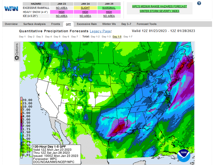
Below is the current five-day cumulative forecast of precipitation (Updates can be found HERE)
Now we look at Intermediate-Term “Outlook” maps for three time periods. Days 6 – 10, Days 8 – 14, and Weeks 3 and 4. An outlook differs from a forecast based on how NOAA uses these terms in that an “outlook” presents information as deviation from normal and the likelihood of these deviations.
Below are the links to obtain updates and additional information. They are particularly useful if you happen to be reading this article significantly later than when it was published. I always try to provide readers with the source of the information in my articles.
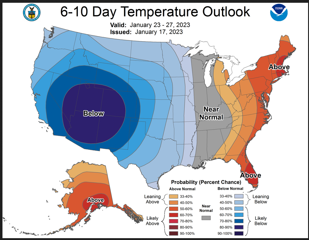
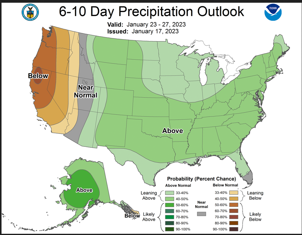
Starting with the 6 to 10 Day Outlooks
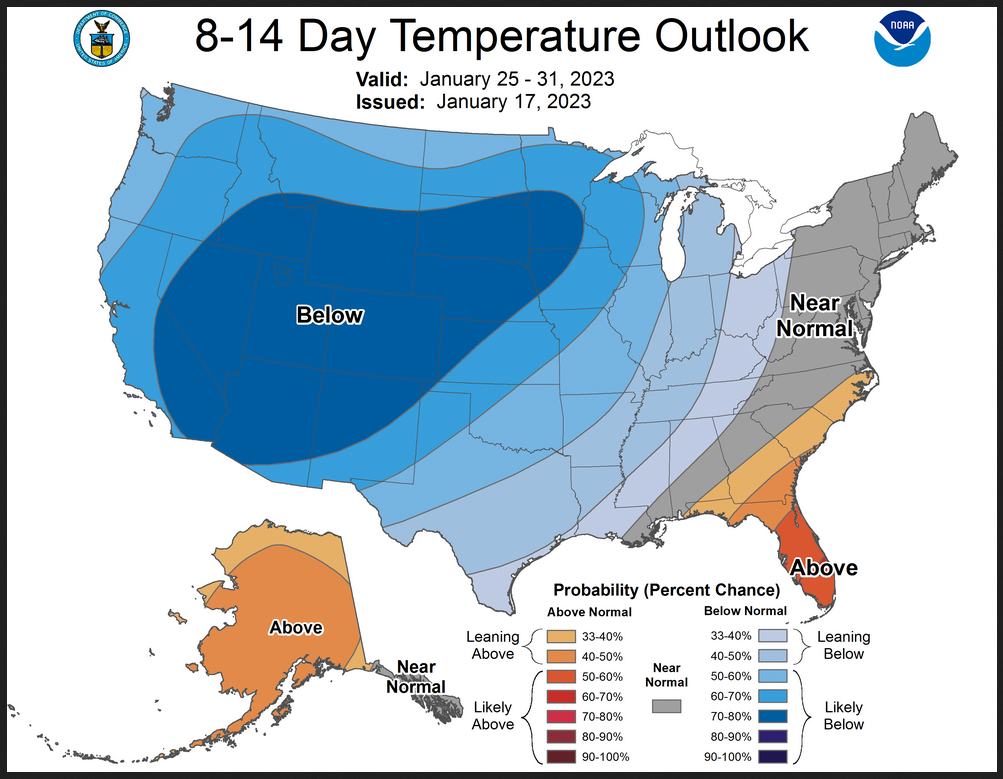
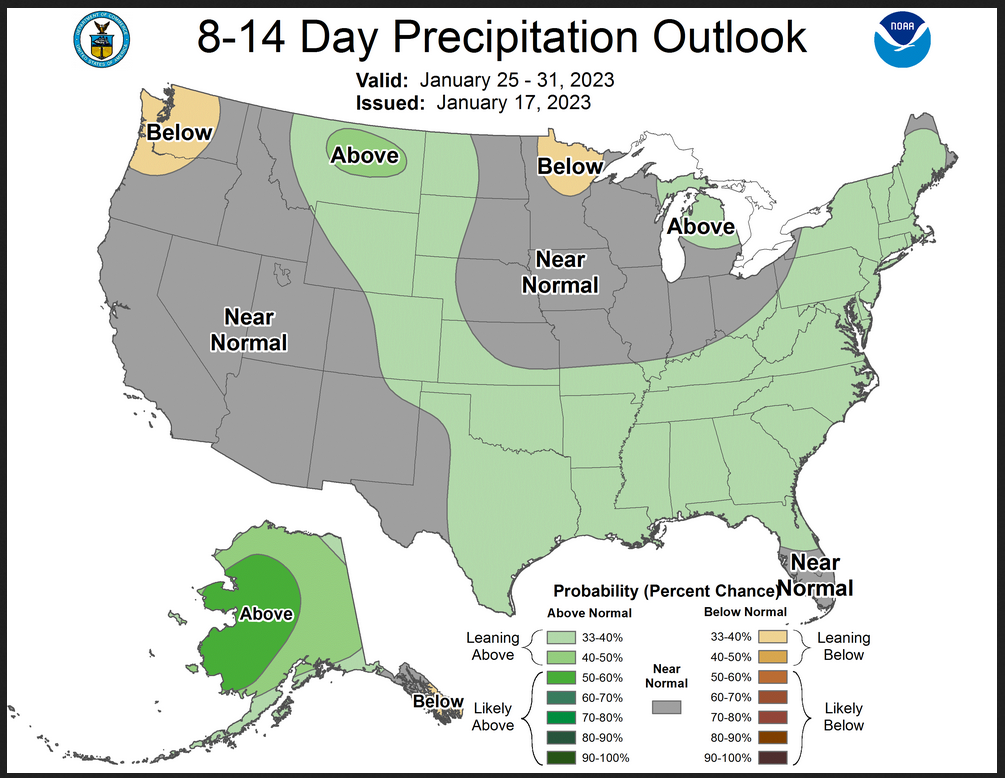
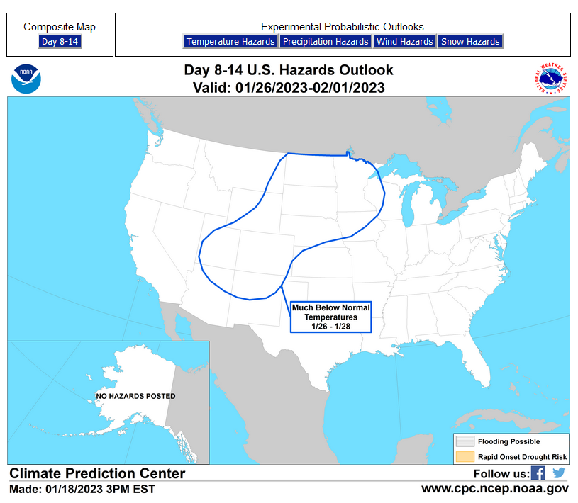
Now let us look a bit farther out to 8 to 14 days. Notice the overlap which reflects the difficulty of predicting exactly when events with happen.
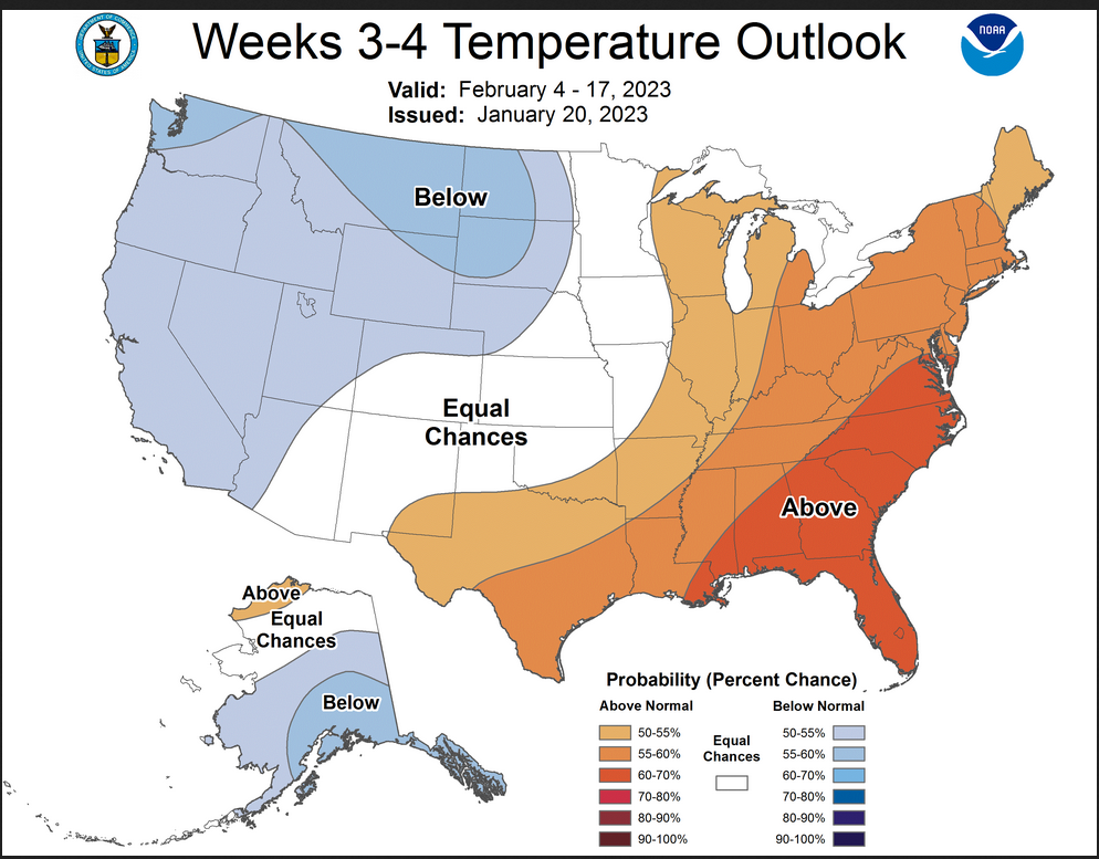
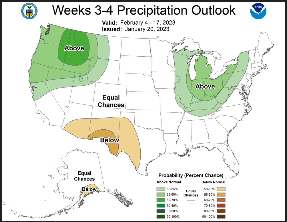
On Fridays, the Week 3 – 4 Outlook updates. So let us take a look.
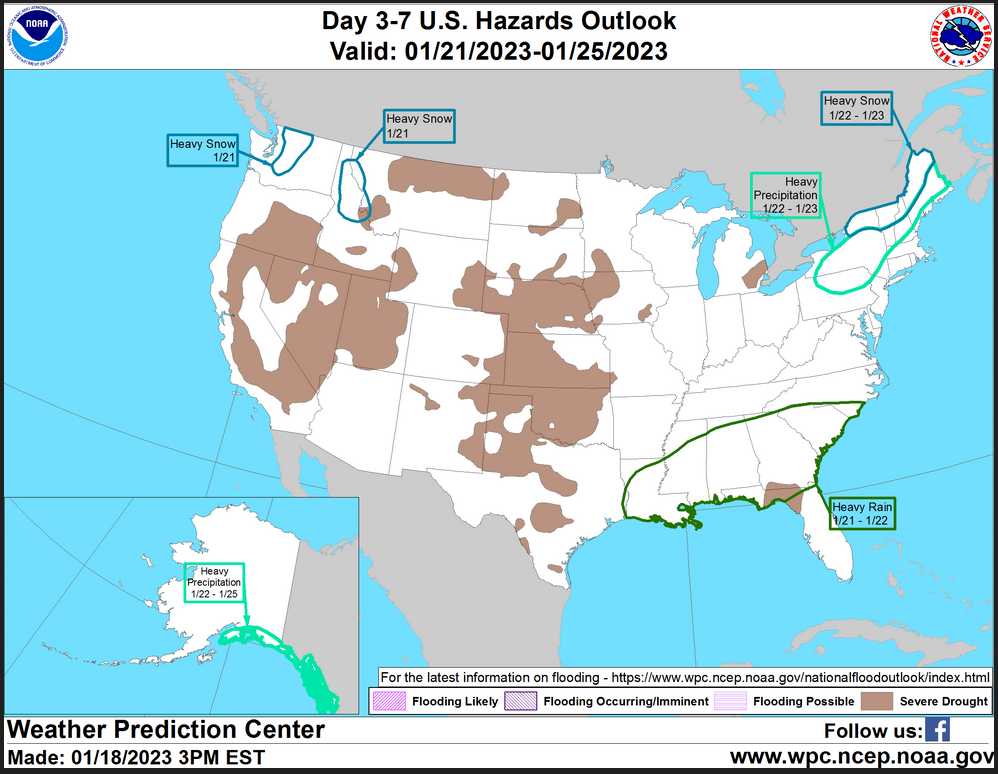
HAZARDS OUTLOOKS
Click here for the latest complete Day 3 -7 Hazards forecast which updates only on weekdays. Once a week probably Monday or Tuesday I will update the images. I provided the link for readers to get daily updates on weekdays. Use your own judgment to decide if you need to update these images. I update almost all the images Friday Night for the weekend edition of this Weather Report. So normally readers do not need to update these images but if the weather is changing quickly you may want to.
 Month to Date Information
Temperature month to date can be found at https://hprcc.unl.edu/products/maps/acis/MonthTDeptUS.png
Precipitation month to date can be found at https://hprcc.unl.edu/products/maps/acis /MonthPNormUS.png
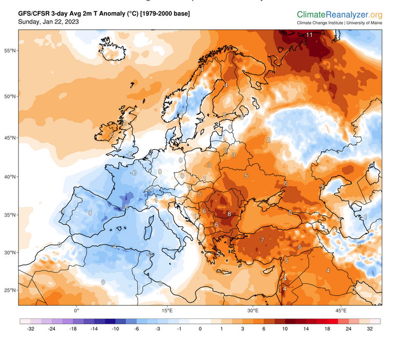
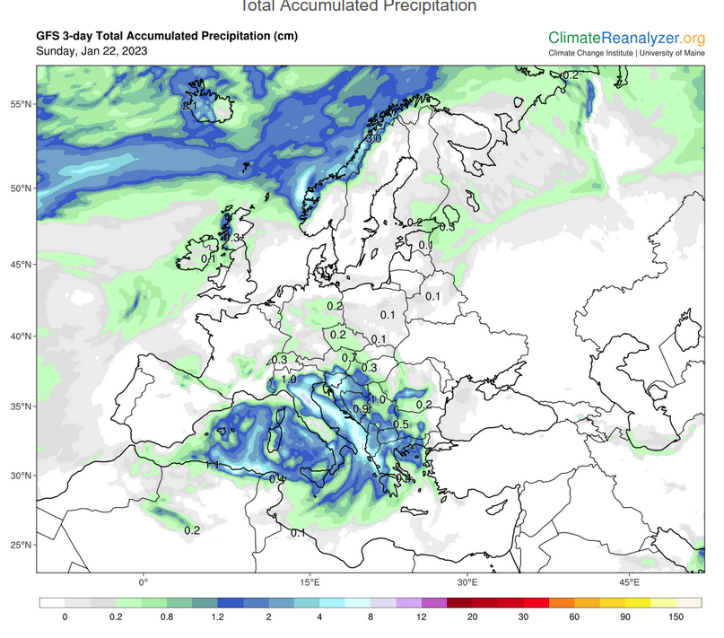
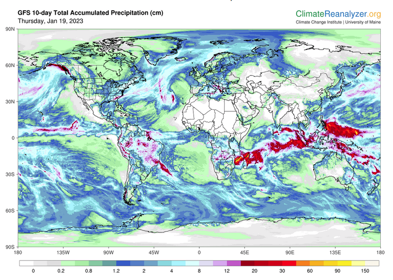
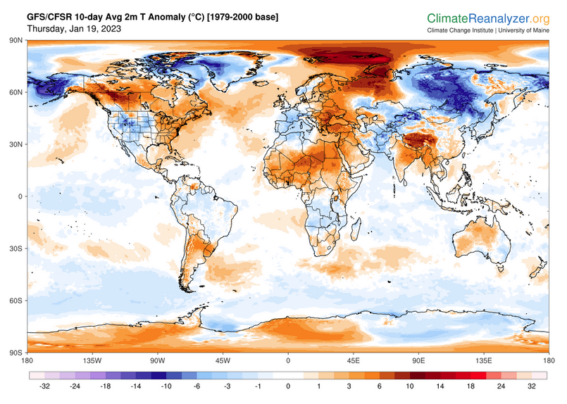
World Forecast
Below are the current precipitation forecast and the 10-Day forecasts for temperature and precipitation. Updates and additional information can be obtained HERE
Much of this information is provided by the University of Maine. They draw upon many different sources.
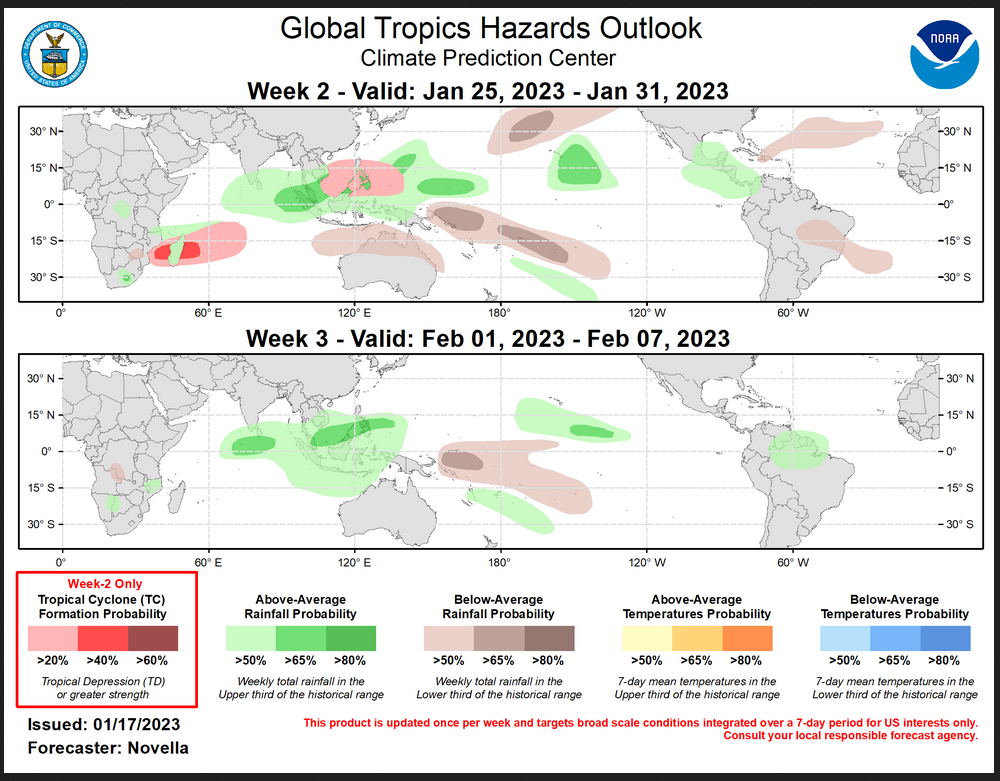
 Worldwide Tropical Forecast (This is a NOAA Product)
This graphic updates on Tuesdays) If it has not been updated, you can get the update by clicking here Readers will only have to do that if they are reading this article much later than the date of it being published.-
| I hope you found this article interesting and useful. |