Updated at 4:05 pm EST Sunday January 15, 2023
Here is what we are paying attention to in the next 48 to 72 hours. This article also includes World weather forecasts.
We start with the U.S. Information.
Short Range Forecast Discussion
NWS Weather Prediction Center College Park MD
137 PM EST Sun Jan 15 2023

Valid 00Z Mon Jan 16 2023 - 00Z Wed Jan 18 2023

...Rain and heavy mountain snow to continue across the West...

...Unseasonably warm temperatures in the central U.S. ahead of a
developing low pressure system this afternoon...

...Periods of snow and a wintry mix persist for coastal New England as the
rest of the East Coast begins a warm up Monday...
![]()
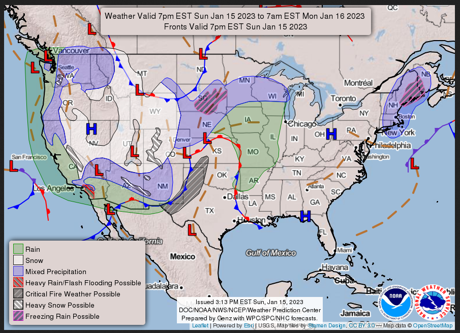
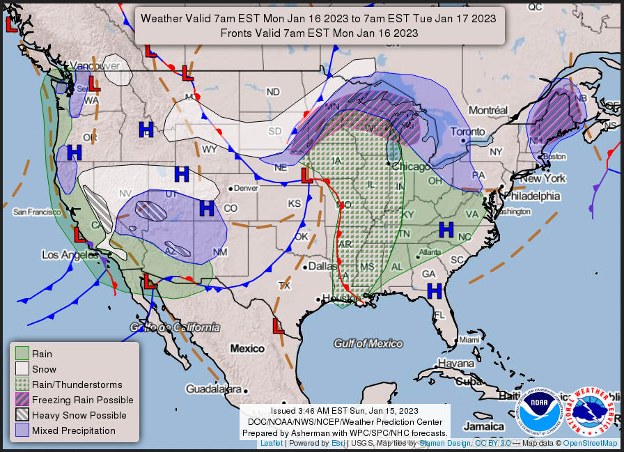
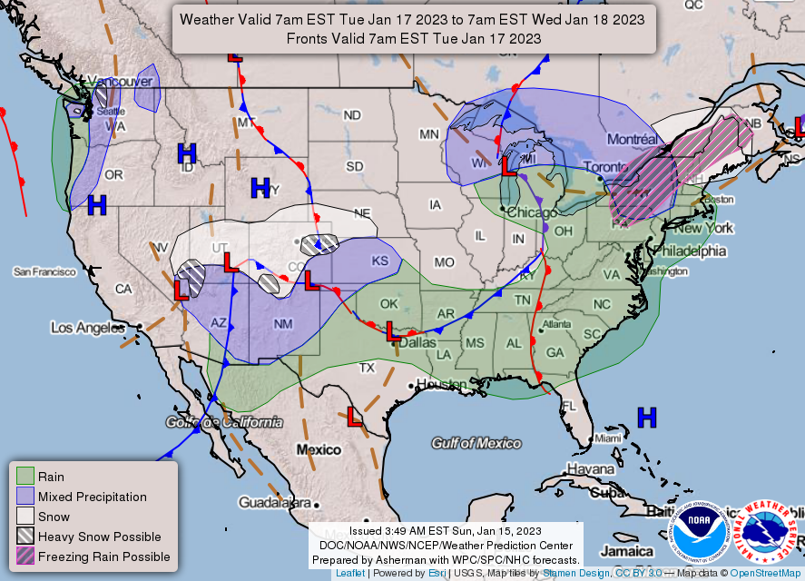
First, the 48-Hour Forecast (It is a 48 to 72 Hour Forecast actually)
Daily weather maps. I try to keep the above maps updated. They only update twice a day and in some cases once a day.
SUNDAY AFTERNOON, EVENING, AND OVERNIGHT
MONDAY
TUESDAY
I will be doing the updating during the period described in the title of the article but if you happen to read this article later you can get updates by clicking HERE.
This animation shows how things may play out over the next 60 hours. To update click here.
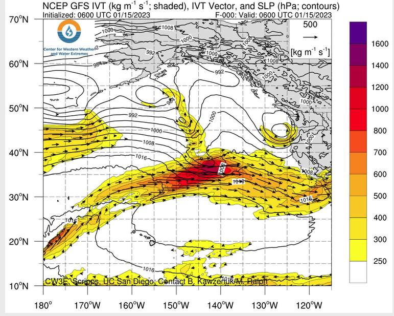
ATMOSPHERIC RIVERS
Continuation of the NWS Short Range Forecast (It is updated by NWS twice a day and these updates can be found here. We post at least one of those updates daily, sometimes both. The Highlights are shown in the lede paragraph of this article.
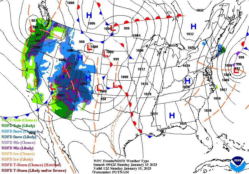
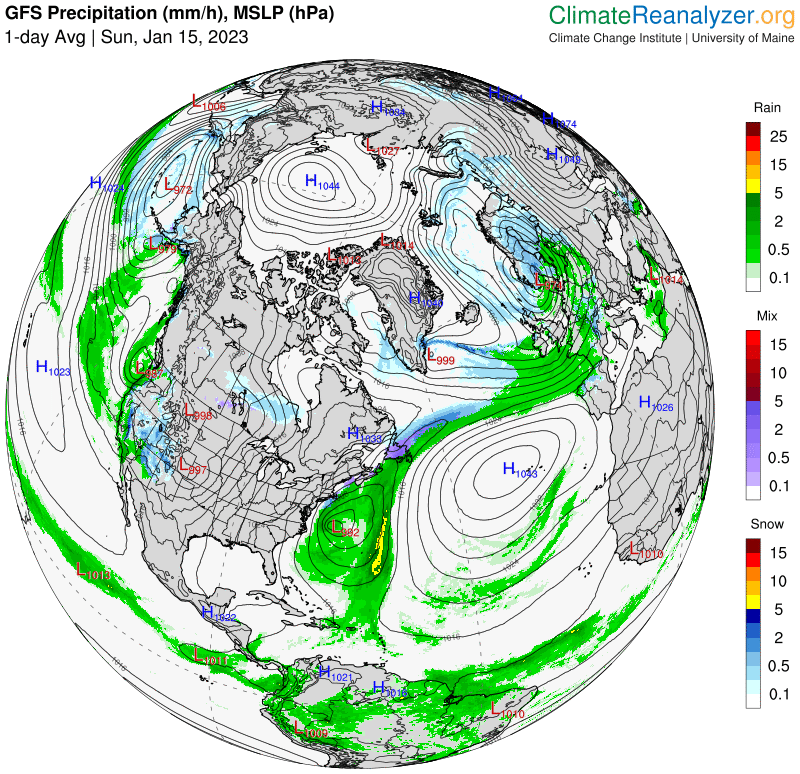
Lower elevation valley/coastal rain and heavy high elevation mountain snow
continue to expand across the west as multiple storm systems affect the
region. The first system that brought more heavy rain and flooding
concerns across California on Saturday is moving through the Great Basin
and towards the Rockies today ahead of another system moving in from the
Pacific early Monday. Showers are forecast to continue along the West
Coast this afternoon, including in California, but totals will be lower
than on Saturday. Still, some isolated higher rain rates of 0.5" per hour
could lead to a couple instances of flooding, especially given the very
wet antecedent conditions. In addition, a plume of higher Pacific moisture
will overspread portions of the Desert Southwest with heavier rain
expected for favorable upslope regions south of the Mogollon Rim in
Arizona.

Rain will also continue for lower elevation valley locations across the
West today, with some snow mixing in outside of the Desert Southwest.
However, any accumulations should remain very light. Heavier snow is
expected at higher elevations in the mountains from the Cascades into the
Great Basin and the Four Corners region. The highest totals through
Tuesday morning will be in the Wasatch, San Juan, and White Mountains, as
well as along the higher elevations of the Mogollon Rim and in the Sierras
where 1-2 feet, locally higher, are forecast. Precipiation chances begin
to taper off for the northern tier of the West Monday as the next storm
system is forecast to take a more southerly track. Isolated cases of
flooding are possible in southern California as well as upslope regions of
the Sierra and Mogollon Rim. High temperatures will be seasonably cool in
the Pacific Northwest and Northern Rockies with mostly 40s expected.
Cooler than average temperatures are forecast further south as clouds and
precipitation linger across the region, with highs only reaching the 50s
for much of the Desert Southwest and the low 60s for southern California.
Highs in the 50s are forecast for central and northern portions of
California, with 30s and 40s for the Great Basin and Central/Southern
Rockies.

A low pressure system is forecast to develop in the lee of the Rockies as
upper-level energy over the West moves out over the Plains. Strong
southerly flow and downsloping winds ahead of the system will lead to high
temperatures upwards of 20-30 degrees above normal. Highs will be in the
60s for portions of the Central and Southern Plains this afternoon,
spreading into the Lower and Middle Mississippi Valley Monday. Highs in
the 70s are forecast for many locations in Texas today with some 80s
expected for far southern Texas Monday. The warm temperatures combined
with increasing winds associated with the lee cyclogenesis and dry
antecedent conditions have prompted a Critical Fire Weather Outlook from
the Storm Prediction Center for portions of the Southern High Plains.
Precipitation chances will ramp up this evening for the Northern/Central
Plains, Midwest, and Mississippi Valley as the storm system strengthens
and begins to track to the northeast. Showers and some thunderstorms are
forecast to continue into Monday for the Mississippi, Ohio, and Tennessee
Valleys while a wintry mix of freezing rain, sleet, and snow will spread
from the High Plains northeastward to the Upper Midwest to the north of
the surface low track. Snow accumulations are expected to remain light,
but a glaze to a tenth of an inch of ice will be possible from eastern
South Dakota through southern Minnesota and northern Wisconsin.

High temperatures will remain on the chilly side this afternoon for the
East Coast as the airmass slowly moderates following the passage of a cold
front earlier this weekend. Highs will range from the 30s in New England
to the 40s in the Mid-Atlantic and 50s in the Southeast outside of south
Florida, where 60s are forecast. Temperatures begin to rebound more on
Monday as 50s overspread portions of the Mid-Atlantic and 60s return to
the South. A wintry mix of freezing rain, sleet, and snow will linger for
coastal New England and Maine as a low pressure system over the Atlantic
tracks northward towards the region. A couple inches of snow are possible
over eastern Massachusetts with some locally higher amounts possible. The
precipitation will be heaviest in Maine, where several inches of snow, an
inch of sleet, and 0.25"+ of freezing rain are possible through Monday
night.
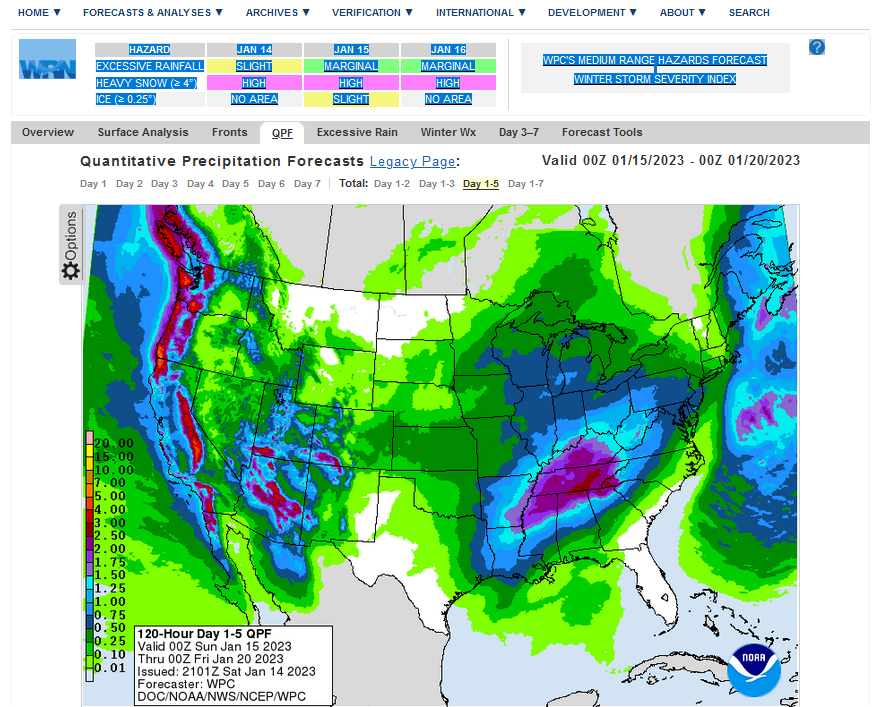
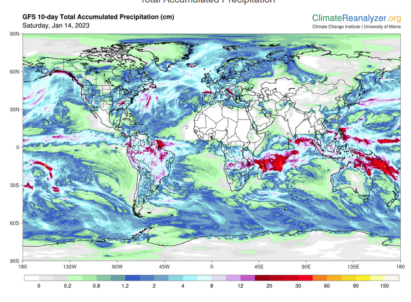
Below is the current five-day cumulative forecast of precipitation (Updates can be found HERE)
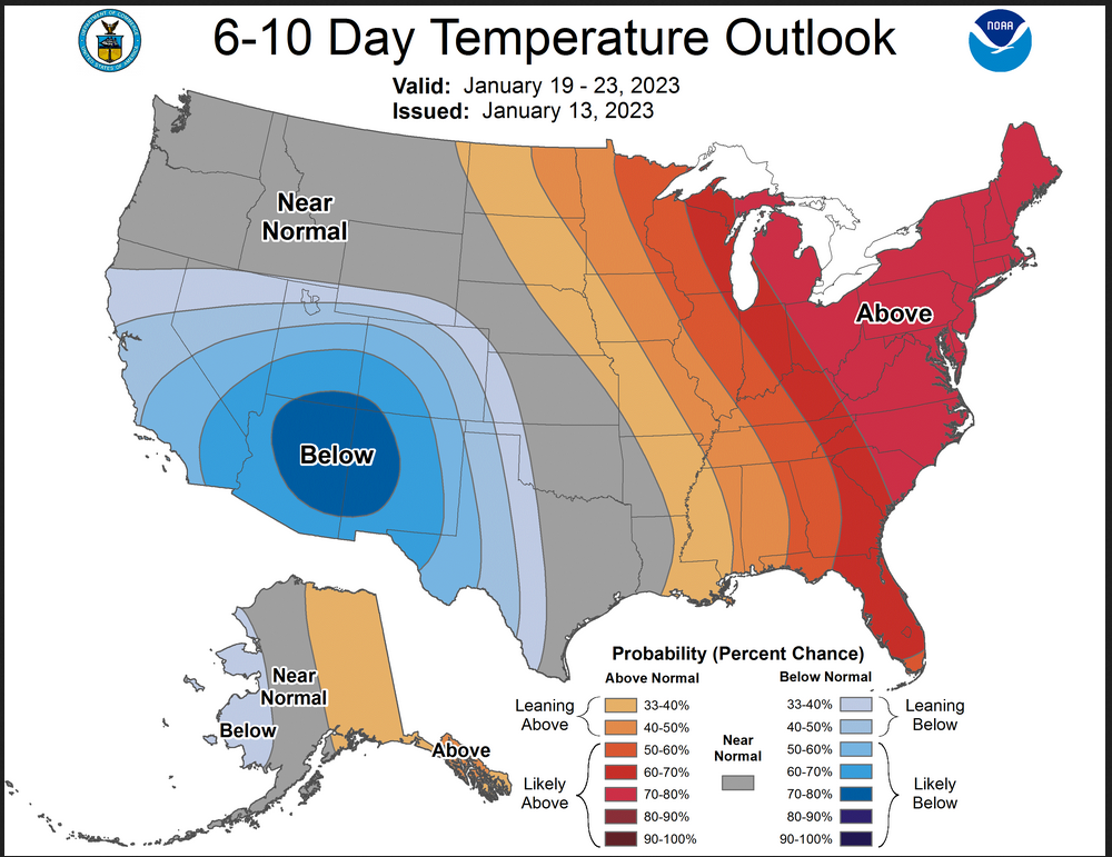
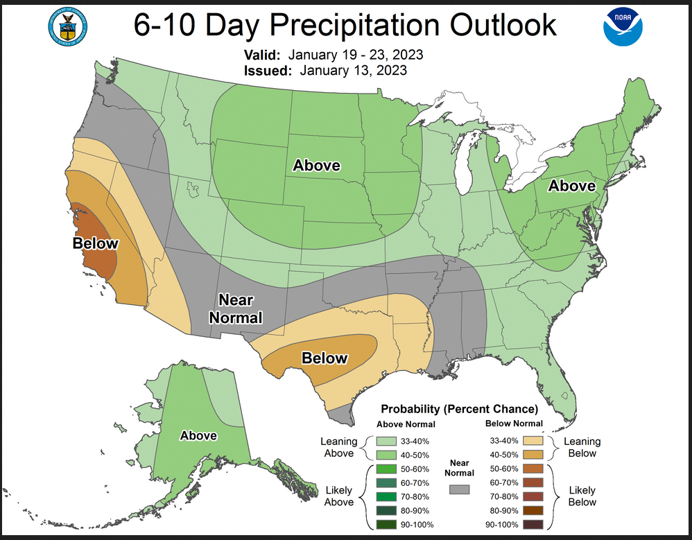
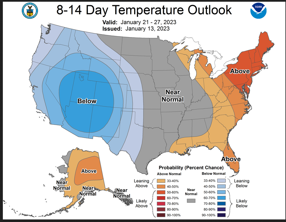
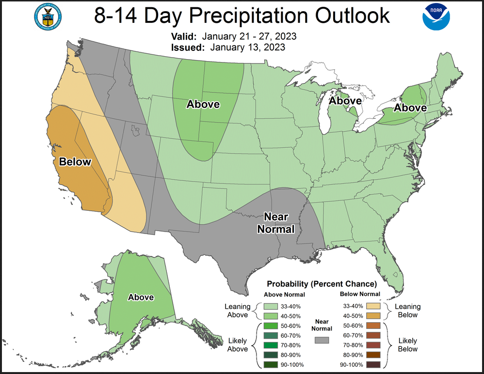
Now we look at Intermediate-Term “Outlook” maps for three time periods. Days 6 – 10, Days 8 – 14, and Weeks 3 and 4. An outlook differs from a forecast based on how NOAA uses these terms in that an “outlook” presents information as deviation from normal and the likelihood of these deviations.
Below are the links to obtain updates and additional information. They are particularly useful if you happen to be reading this article significantly later than when it was published. I always try to provide readers with the source of the information in my articles.
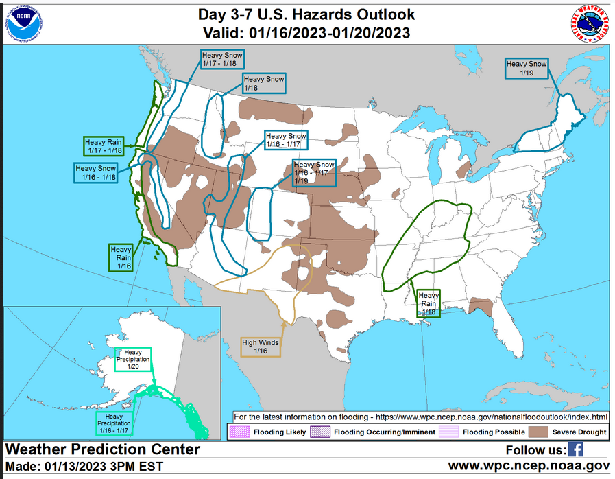
HAZARDS OUTLOOKS
Click here for the latest complete Day 3 -7 Hazards forecast which updates only on weekdays. Once a week probably Monday or Tuesday I will update the images. I provided the link for readers to get daily updates on weekdays. Use your own judgment to decide if you need to update these images. I update almost all the images Friday Night for the weekend edition of this Weather Report. So normally readers do not need to update these images but if the weather is changing quickly you may want to.
Month to Date Information
Temperature month to date can be found at https://hprcc.unl.edu/products/maps/acis/MonthTDeptUS.png
Precipitation month to date can be found at https://hprcc.unl.edu/products/maps/acis /MonthPNormUS.png
World Forecast
Below are the current precipitation forecast and the 10-Day forecasts for temperature and precipitation. Updates and additional information can be obtained HERE
Much of this information is provided by the University of Maine. They draw upon many different sources.
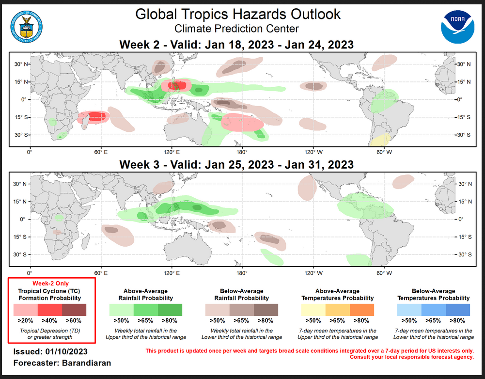
 Worldwide Tropical Forecast (This is a NOAA Product)
This graphic updates on Tuesdays) If it has not been updated, you can get the update by clicking h ere Readers will only have to do that if they are reading this article much later than the date of it being published.
–
| I hope you found this article interesting and useful. |