Updated at 4:30 p.m. EST December 30, 2022

The “Happy New Year” is a bit early for sure but I hate being late for a party.
Here is what we are paying attention to in the next 48 hours from Friday afternoon’s NWS Forecast. This is a combination of a U.S. plus World Weather Article. We start with the U.S. Information.
Short Range Forecast Discussion
NWS Weather Prediction Center College Park MD
158 PM EST Fri Dec 30 2022

Valid 00Z Sat Dec 31 2022 - 00Z Mon Jan 02 2023

...Much above average temperatures expected across much of the central to
eastern U.S. as 2022 ends and 2023 begins...

...Wet weather pattern to continue across large portions of the West coast
with Flash Flooding possible through large portions of California...

...The New Year will ring in wet from Southern California, through
Southern Nevada into Northern Utah and from New York City into New
England...
![]()
First, the 48-Hour Forecast (It is a 48 to 72 Hour Forecast actually)
Daily weather maps
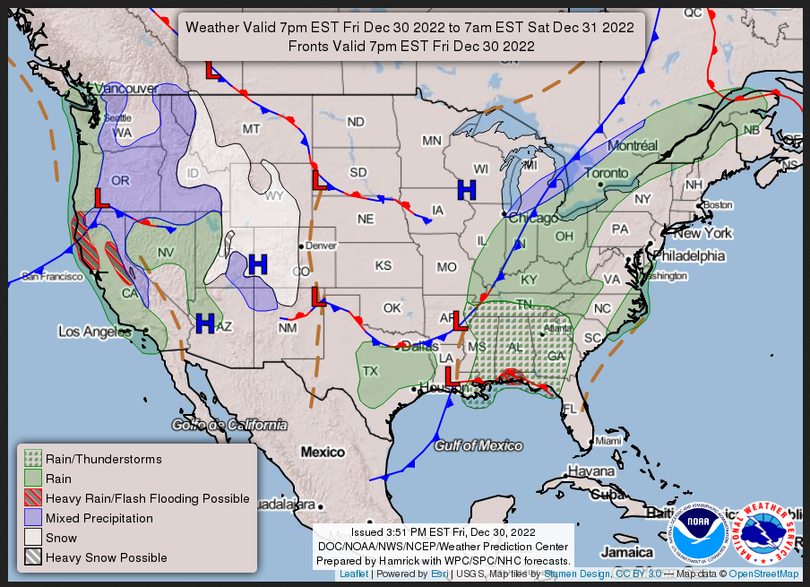
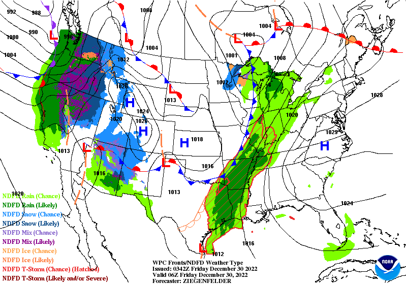
FRIDAY AFTERNOON, EVENING AND OVERNIGHT
SATURDAY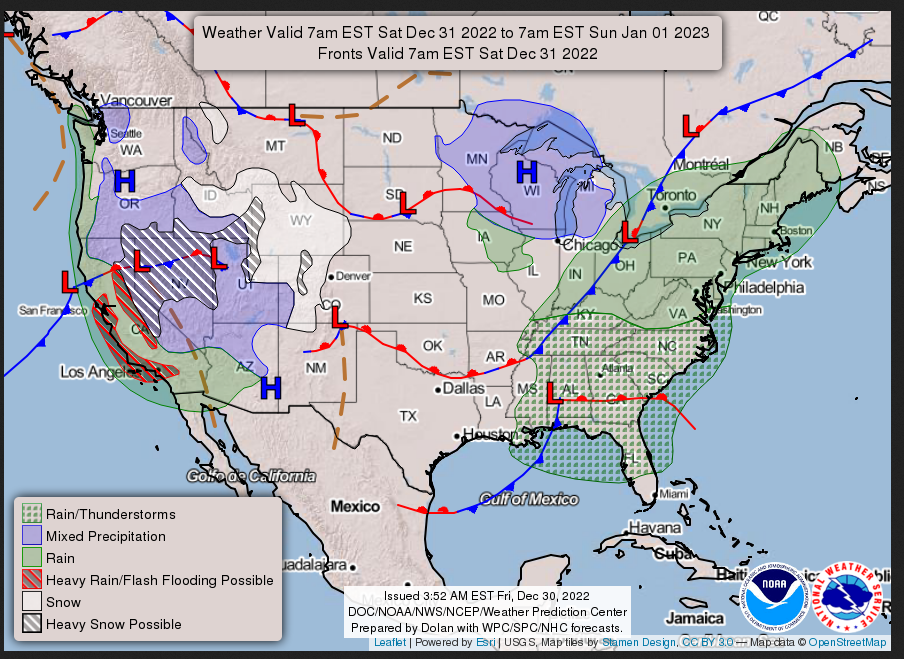
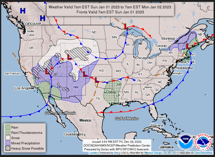
SUNDAY
I try to keep the above maps updated. They only update twice a day and in some cases once a day.
I will be doing the updating during the period described in the title of the article but if you happen to read this article later you can get updates by clicking Here for Day 1 and Here for Day 2. This link works also.
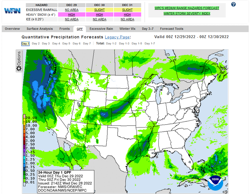
Below is the current three-day cumulative forecast of precipitation (Updates can be found HERE)
his animation shows how things may play out over the next 60 hours. To update click here.
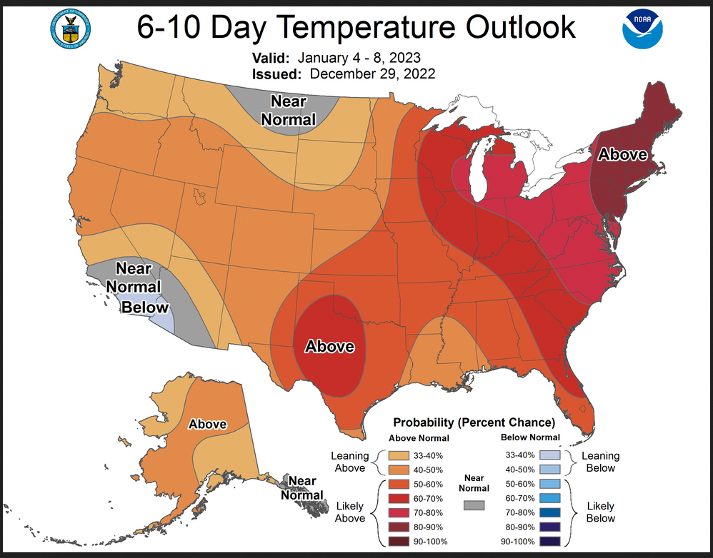
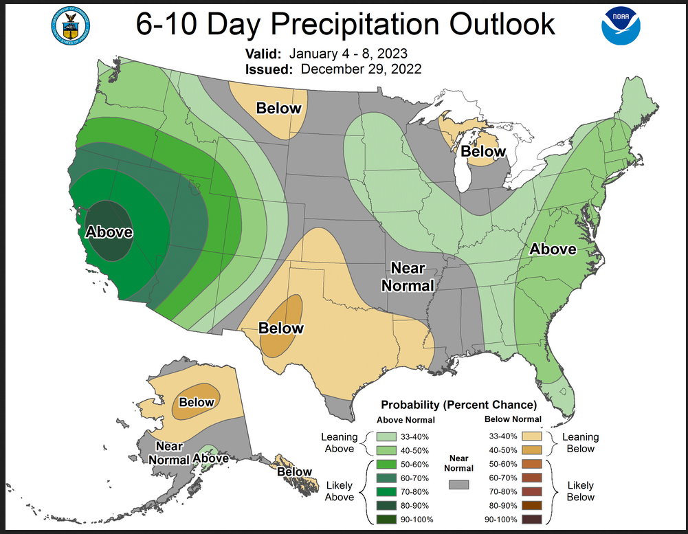
| Temperature (Maximum or Minimum Anomaly) for Days 3 – 7 |
Precipitation (Five days of cumulative precipitation) |
| https://www.wpc.ncep.noaa.gov/medr/medr_mean.shtml | https://www.wpc.ncep.noaa.gov/qpf/day1-7.shtml |
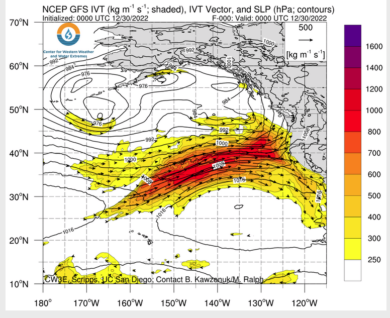
ATMOSPHERIC RIVERS
Continuation of the NWS Short Range Forecast (It is updated by NWS twice a day and these updates can be found here. We post at least one of those updates daily, sometimes both. The Highlights are shown in the lede paragraph of this article.
Arctic air will remain absent from the Lower 48 as 2022 ends and 2023
begins with a progressive, generally west to east, mid to upper level flow
pattern expected across the U.S.   This pattern will continue to support
much above average temperatures for the central to eastern U.S. along
with numerous record high minimum temperatures possible Friday morning
across Southern California, Southern Nevada and portions of the east.
Additional numerous record high minimum temperatures possible New Year's
morning across much of the Northeast from Washington D.C. into Boston and
over the Southwest.  In addition to the much above average temperatures,
New Year's Eve may be wet from Southern California, northeast into
southern Nevada and northern Utah and from New York City to Boston.

The recent wet weather pattern for large portions of the West coast will
continue over the next several days. The next in the series of heavy
precipitation events to affect the west coast will be sinking south Friday
night from northern California and the Great Basin, into central
California and the Sierra on Saturday and into Southern California and
portions of the Southwest by New Year's day.  High snow elevations will
result in a greater than average amount of the heavy precipitation in the
Sierra falling as rain, increasing the potential for flash flooding in the
interior California Valleys.  Flash flooding also possible across much of
the California coastal regions, especially over any recent burn scar
areas.  These rains will, however, be very beneficial to areas of
California and Nevada that remain in long term Severe to Exceptional
drought.

Heavy rains are also possible Thursday afternoon into Thursday evening
across the Gulf Coast from southern Mississippi across the Florida
Panhandle.  This heavy rain threat is expected to diminish by or shortly
after midnight Saturday, but an overall showery wet pattern will continue
Saturday across the eastern third of the country.
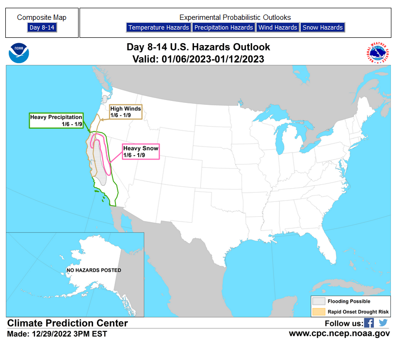
Now we look at Intermediate-Term “Outlook” maps for three time periods. Days 6 – 10, Days 8 – 14, and Weeks 3 and 4. An outlook differs from a forecast based on how NOAA uses these terms in that an “outlook” presents information as deviation from normal and the likelihood of these deviations.
I have provided the 6 – 10 day maps (and I usually update it every two days) so you do not need to click to get them but you will have to click on the links for the Day 8 -14 and Week 3- 4 period. The maps do not update daily. But you can get the current images simply by clicking on the links provided. Then hit the return arrow at the upper left of your screen to return to the article. There is no need to do that right away since what is published today is up to date as of the original publish date so they can be updated during the weekend if you want. It is probably not necessary to do that. The Week 3 – 4 Outlook only updates on Fridays.
Below are the links to obtain updates and additional information. They are particularly useful if you happen to be reading this article significantly later than when it was published. I always try to provide readers with the source of the information in my articles.
 –
–
| California is wet, Southern Great Plains drying out. |
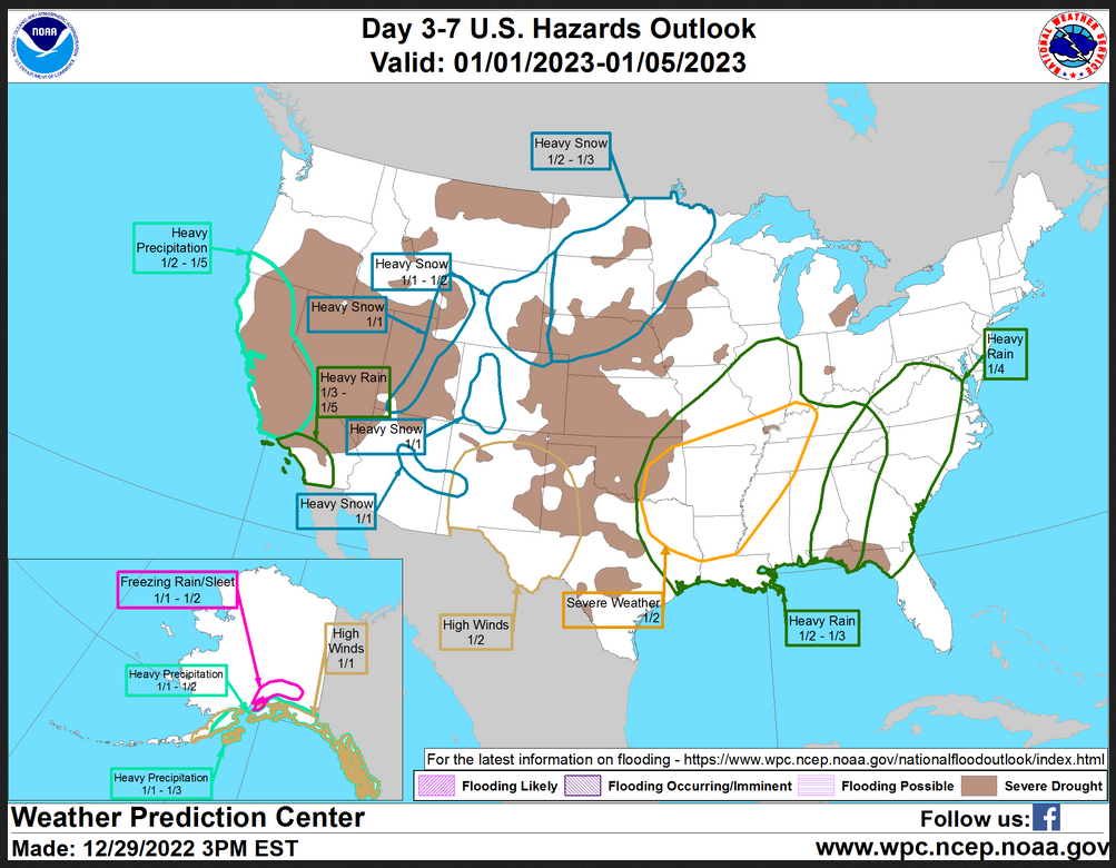
HAZARDS OUTLOOKS
Click here for the latest complete Day 3 -7 Hazards forecast which updates only on weekdays. Once a week probably Monday or Tuesday I will update the images. I provided the link for readers to get daily updates on weekdays. Use your own judgment to decide if you need to update these images. I update almost all the images Friday Night for the weekend edition of this Weather Report. So normally readers do not need to update these images but if the weather is changing quickly you may want to.
Month to Date Information
Temperature month to date can be found at https://hprcc.unl.edu/products/maps/acis/MonthTDeptUS.png
Precipitation month to date can be found at https://hprcc.unl.edu/products/maps/acis /MonthPNormUS.png
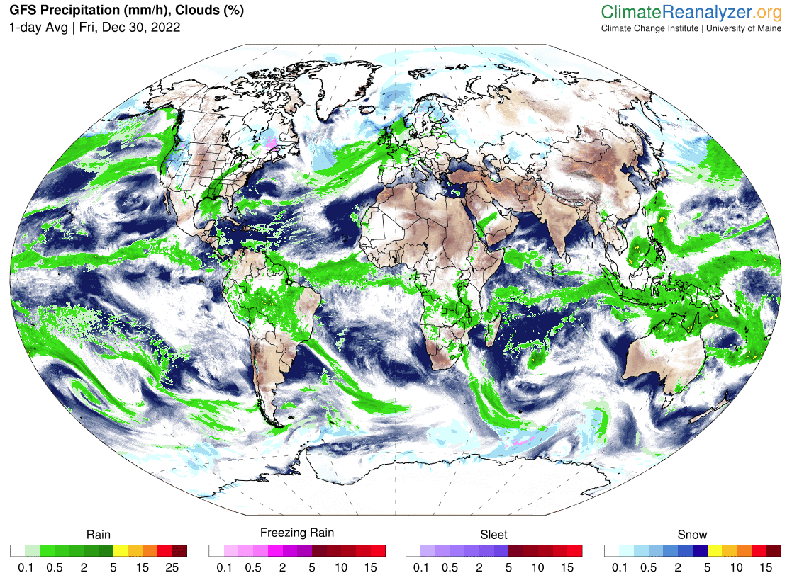
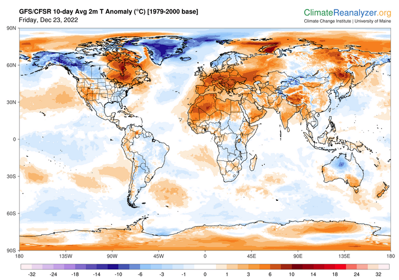
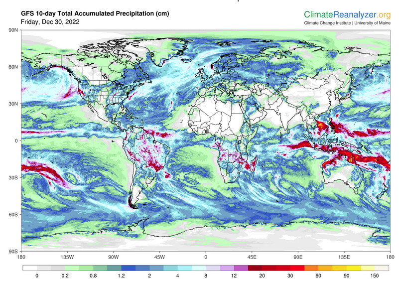
World Forecast
Below are the current precipitation forecast and the 10-Day forecasts for temperature and precipitation. Updates and additional information can be obtained HERE
Much of this information is provided by the University of Maine. They draw upon many different sources.
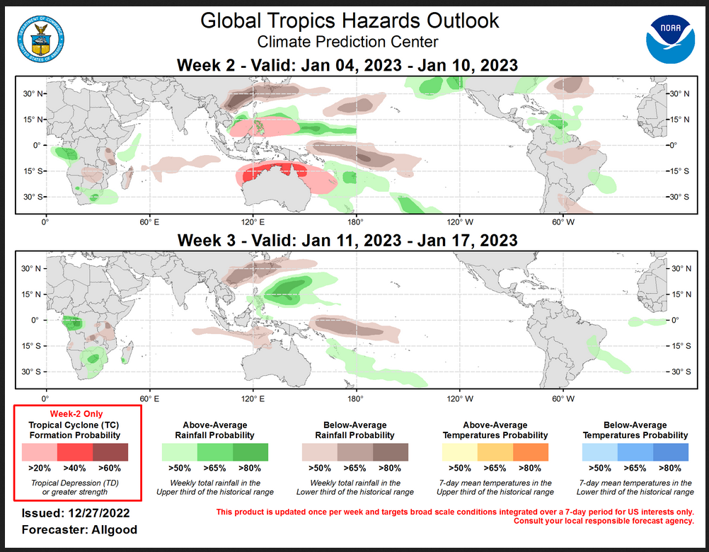
Worldwide Tropical Forecast (This is a NOAA Product)
This graphic updates on Tuesdays) If it has not been updated, you can get the update by clicking here Readers will only have to do that if they are reading this article much later than the date of it being published.
| I hope you found this article interesting and useful. |