Updated at 4:08 p.m. EST December 28, 2022
Here is what we are paying attention to the next 48 hours from Wednesday Morning’s NWS Forecast. This is a combination of a U.S. plus World Weather Article. We start with the U.S. Information.
Short Range Forecast Discussion
NWS Weather Prediction Center College Park MD
252 PM EST Wed Dec 28 2022

Valid 00Z Thu Dec 29 2022 - 00Z Sat Dec 31 2022

...Next surge of heavy rain and mountain snow to enter the West on
Thursday and continue through the end of the week...

...Increasing shower and thunderstorm chances across parts of the Gulf
Coast and lower Mississippi Valley...

...Well above average temperatures forecast throughout the central and
eastern United States...
![]()
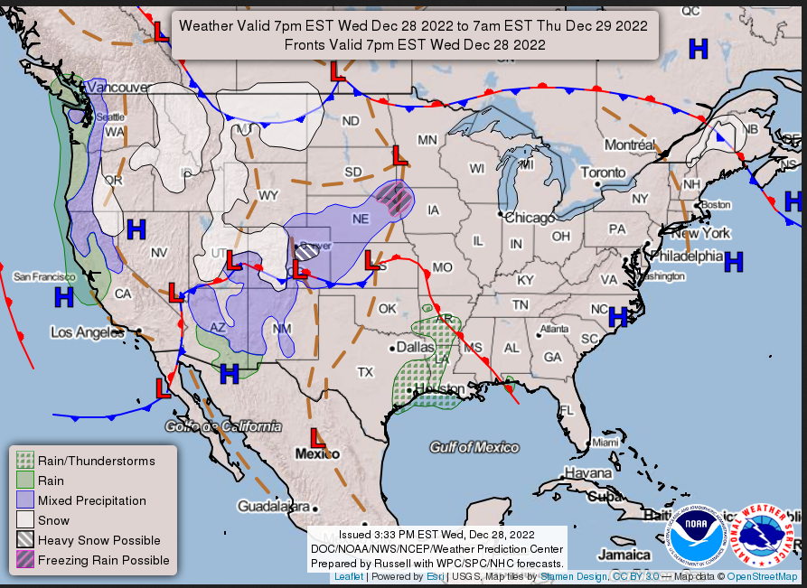
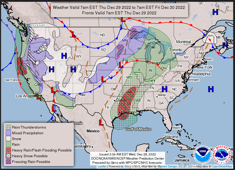
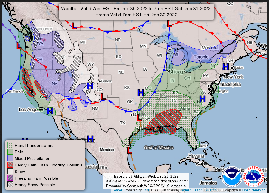
We start with the 48-Hour Forecast
Continuation of the NWS Short Range Forecast (It is updated by NWS twice a day and these updates can be found here. We post at least one of those updates daily, sometimes both.
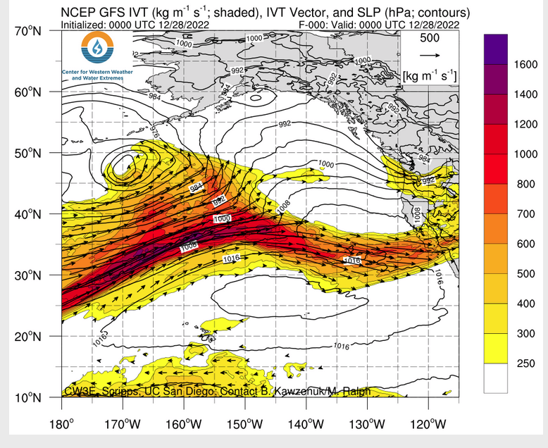
A relatively warm and wet weather pattern overspreading the Nation through
at least the next few days is anticipated to produce heavy precipitation
across the West Coast and parts of the Deep South. For the western U.S., a
lull in unsettled weather today will be replaced by potentially excessive
rainfall and heavy mountain snow beginning on Thursday as an initial wave
of moisture moves onshore followed by a potent atmospheric river. Most of
the potential impacts are anticipated across central/northern California
and parts of southwest Oregon. Here, rainfall amounts of 3 to 6 inches are
forecast through early this weekend. Heavy rain may lead to scattered
instances of flash flooding, especially near recent burn scars where
terrain is most susceptible to rapid runoff. A Slight Risk (level 2/4) of
Excessive Rainfall has been issued for these regions in order to further
highlight the flash flood threat. Heavy snow is possible across the higher
elevations of the Cascades and Sierra, with storm total snowfall amounts
up to several feet are possible. Most of the snow will be confined to the
highest terrain as warm Pacific air pushes snow levels very high and
generally above pass level. Moisture will also spread into the
Intermountain West along the strong Pacific jet stream, with moderate to
heavy snow possible across northern Nevada by Friday night.

Shifting to the central and eastern U.S., an upper-level trough swinging
into the Great Plains tonight in conjunction with a high pressure system
sliding off the East Coast will allow for an abundance of warm and moist
air to surge northward out of the Gulf of Mexico. A quick-hitting swath of
snowfall is possible to the north of a developing low pressure system
between tonight and Thursday as it progresses from Kansas to the Upper
Midwest. The best chances for over 4 inches of snow is currently expected
to remain confined to central High Plains of Colorado. Farther east,
shower and thunderstorm activity is anticipated to develop across parts of
eastern Texas and the Lower Mississippi Valley on Thursday and Friday as
atmospheric moisture content increases ahead of an approaching cold front.
Some isolated storms could turn severe, with damaging wind gusts the
primary risk. A few instances of flash flooding are also possible. The
active weather is expected to shift east by the end of the week and
produce locally heavy rainfall from the central Gulf Coast to parts of the
Ohio Valley.

Otherwise, a majority of the Lower 48 will experience drastically warmer
temperatures than this past weekend as a continuing warm up pushes the
late-December thaw into overdrive. As mild air surges northward around the
high pressure system pushing into the western Atlantic, highs into the 50s
and 60s will be easy to find throughout the eastern third of the Nation.
Low temperatures will reach into record warm territory throughout the
Great Lakes and Interior Northeast by Friday, where overnight lows are not
expected to drop below the upper 30s. This equates to over 20 degrees
above average compared to climatology.
Daily weather maps
WEDNESDAY AFTERNOON THROUGH OVERNIGHT
THURSDAY
 FRIDAY
I try to keep the above maps updated. They only update twice a day and in some cases once a day.
I will be doing the updating during the period described in the title of the article but if you happen to read this article later you can get updates by clicking Here for Day 1 and Here for Day 2. This link works also.
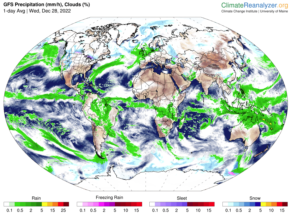
Below is the current three-day cumulative forecast of precipitation (Updates can be found HERE)

his animation shows how things may play out over the next 60 hours. To update click here.
| Temperature (Maximum or Minimum Anomaly) for Days 3 – 7 |
Precipitation (Five days of cumulative precipitation) |
| https://www.wpc.ncep.noaa.gov/medr/medr_mean.shtml | https://www.wpc.ncep.noaa.gov/qpf/day1-7.shtml |
ATMOSPHERIC RIVERS
 —
—
Now we look at Intermediate-Term “Outlook” maps for three time periods. Days 6 – 10, Days 8 – 14, and Weeks 3 and 4. An outlook differs from a forecast based on how NOAA uses these terms in that an “outlook” presents information as deviation from normal and the likelihood of these deviations.
I have provided the 6 – 10 day maps (and I usually update it every two days) so you do not need to click to get them but you will have to click on the links for the Day 8 -14 and Week 3- 4 period. The maps do not update daily. But you can get the current images simply by clicking on the links provided. Then hit the return arrow at the upper left of your screen to return to the article. There is no need to do that right away since what is published today is up to date as of the original publish date so they can be updated during the weekend if you want. It is probably not necessary to do that. The Week 3 – 4 Outlook only updates on Fridays.
Below are the links to obtain updates and additional information. They are particularly useful if you happen to be reading this article significantly later than when it was published. I always try to provide readers with the source of the information in my articles.

 –
–
| Warm and wet. That is a big change |
HAZARDS OUTLOOKS
Click here for the latest complete Day 3 -7 Hazards forecast which updates only on weekdays. Once a week probably Monday or Tuesday I will update the images. I provided the link for readers to get daily updates on weekdays. Use your own judgment to decide if you need to update these images. I update almost all the images Friday Night for the weekend edition of this Weather Report. So normally readers do not need to update these images but if the weather is changing quickly you may want to.

 Month to Date Information
Temperature month to date can be found at https://hprcc.unl.edu/products/maps/acis/MonthTDeptUS.png
Precipitation month to date can be found at https://hprcc.unl.edu/products/maps/acis /MonthPNormUS.png
World Forecast
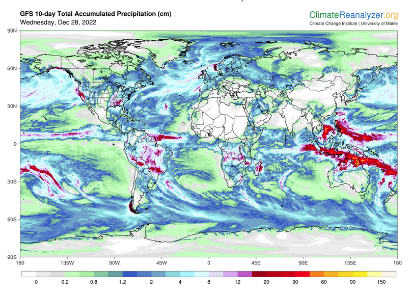
Below are the current precipitation forecast and the 10-Day forecasts for temperature and precipitation. Updates and additional information can be obtained HERE
Much of this information is provided by the University of Maine. They draw upon many different sources.
Worldwide Tropical Forecast (This is a NOAA Product)

This graphic updates on Tuesdays) If it has not been updated, you can get the update by clicking here Readers will only have to do that if they are reading this article much later than the date of it being published.
| I hope you found this article interesting and useful. |