Updated at 3:06 p.m. EST Wednesday December 21, 2022
Short Range Forecast Discussion
NWS Weather Prediction Center College Park MD
300 PM EST Wed Dec 21 2022

Valid 00Z Thu Dec 22 2022 - 00Z Sat Dec 24 2022

...Powerful winter storm to produce a multitude of weather hazards across
the central and eastern United States through the end of the week...

...Bitter cold and life-threatening wind chills over the northern Plains
to surge southward this evening and swing towards the East Coast on
Friday...

...Significant freezing rain possible across parts of western Oregon and
Washington beginning Thursday night...
Continuation of the NWS Short Range Forecast (It is updated by NWS twice a day and these updates can be found here. We post at least one of those updates daily, sometimes both.
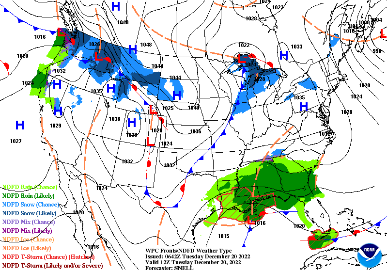
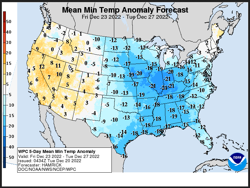
A significant and disruptive storm system is forecast to produce a
multitude of weather hazards over the next several days, as heavy
snowfall, strong winds, and dangerously cold temperatures span from the
Intermountain West through the Plains, the Great Lakes, and the central
Appalachians. At the forefront of the active weather pattern is a
dangerous and record-breaking cold air mass in the wake of strong arctic
cold front diving southward across the central Plains today and the
southern Plains by late Thursday. Behind the front, temperatures across
the Intermountain West and northern High Plains have plummeted 25 - 35
degrees F in just a few hours, with widespread minus 10 to minus 20
readings across the region. This, combined with sustained winds of 20 - 30
mph and higher wind gusts of up to 60 mph, have and will continue to lead
to wind chills as low as minus 40 degrees across a large swath of the
Intermountain West and northern/central Plains, with more localized areas
of minus 50 to minus 70 possible through the end of the week. Wind chills
of this magnitude can cause frostbite in less than 5 minutes if
precautions are not taken, with hypothermia and death also possible from
prolonged exposure to the cold. Livestock interests will also be severely
impacted and dangers could be exacerbated if power outages occur.
Consequently, widespread Wind Chill Warnings have been issued for areas
spanning from eastern Washington State, through the Intermountain West,
central/northern Plains, and Tennesse Valley, with additional Wind Chill
Watches and Advisories covering areas as far south as the southern Plains
and Gulf Coast. As the arctic front dives southward through the overnight
hours and Thursday, daytime temperatures across the central Plains will
struggle to get above 0 degrees, while areas further south in Texas and
the Gulf Coast will experience temperatures in the single digits and teens
Thursday evening. Furthermore, snow squalls, or a brief burst of moderate
to heavy snow (1 to 2 hours), are likely to occur immediately behind the
arctic front from the Intermountain West, to the central Plains, Ohio
Valley, Mid-Atlantic, and Northeast. Developing snow squalls could lead to
extremely hazardous travel conditions at times, as they will be
accompanied by gusts to 40 mph, potentially creating sudden whiteout
conditions.

Another hazardous facet of the system will be a deepening low-pressure
center that forms along the frontal boundary this evening and rapidly
strengthens as it tracks eastward across the Midwest and Great Lakes on
Thursday. This storm system is likely to produce widespread
light-to-moderate snowfall from the Midwest to the Great Lakes and
Interior Northeast, with a brief burst of snow also possible into the
Ohio/Tennessee Valleys and northern Mid-Atlantic immediately following the
cold frontal passage. The heaviest snowfall, with amounts potentially
exceeding a foot, is anticipated to occur over the Great Lakes between
tonight and Friday, especially along westward and northward-facing
lakefronts, as lake-enhanced snowfall along with moisture wrapped around
the low will help aid in the locally heavy totals. Combined with the
snowfall, very strong winds will also accompany the system as a very tight
pressure gradient develops between the low over the Great Lakes and the
strong high-pressure system over the northern Plains. Heavy snowfall rates
of 1-2"/hour, along with wind gusts of over 50 mph will result in
near-zero visibility and considerable blowing and drifting of snow. This
will lead to dangerous, to at times impossible, land and air travel
leading up to the holiday weekend. The combination of heavy snow and
strong wind gusts could lead to significant infrastructure impacts,
including scattered tree damage and power outages. Residents across the
aforementioned regions are advised to make final preparations as soon as
possible and check on family and friends during the storm in case of an
emergency.

Further east, in the warm sector of the strengthening storm system,
moisture surging northward ahead of a center of low-pressure and
associated coastal boundary situated off the Southeast coast will lead to
moderate to heavy rainfall across the Southeast and Mid-Atlantic on
Thursday with rainfall totals of 1-3" possible. As the low-pressure system
tracks northward Thursday evening, strong southerly winds ahead of the
center of low-pressure, combined with the new moon-tide cycle, may lead to
dangerous coastal flooding from northern New Jersey to northeast
Massachusetts. Furthermore, heavy rain over a fresh snowpack could also
create scattered flooding concerns for parts of Vermont and Maine on
Friday, which has prompted a Slight Risk (level 2/4) of Excessive Rainfall
to be issued. Lastly, at the leading edge of the northward surging
moisture over the Mid-Atlantic during the first half of the day on
Thursday, light freezing rain and locally heavy snowfall could impact
parts of the central Appalachians. A lingering cold air damming
environment will likely keep this brief punch of wintry weather confined
to the higher terrain and near the Blue Ridge mountains, but could still
lead to snowfall totals of up to six inches in some spots. Moreover, on
Friday, as the arctic cold front races eastward across the Mid-Atlantic
and Northeast, temperatures will plunge from the mid-to-upper 50s to the
10s and 20s in a matter of hours, which could lead to a rapid flash freeze
of wet pavement and surfaces from antecedent rainfall.

Looking forward, the next storm system to impact the Pacific Northwest
will spread precipitation and gusty winds onshore by late Thursday ahead
of an approaching warm front. After initially starting as snow, sleet and
freezing rain is likely to develop and could linger for an extended amount
of time over parts of western Washington and northwestern Oregon. This
changeover to freezing rain is due to a dense arctic airmass remaining in
place at the surface while warmer air surges over the region in the upper
levels. Localized ice accretion of a half inch could create the potential
for dangerous travel conditions and scattered power outages.
Day 1 and Day 2 Maps can be found by clicking Here for Day 1 and Here for Day 2. This Link works also.
WEDNESDAY Evening and Overnight

THURSDAY

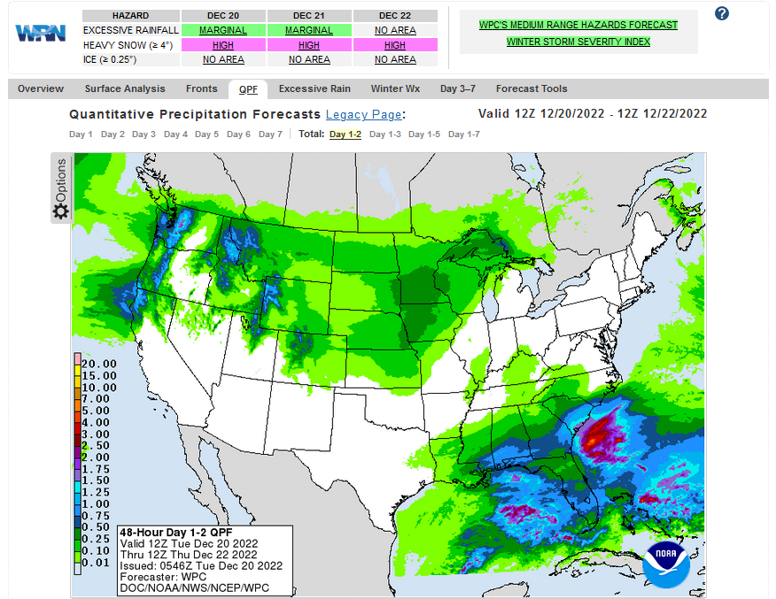
Current Two-day forecast of heavy precipitation (Updates can be found HERE)
Here is a 60-hour animated forecast map that shows how the short-term forecast is expected to play out
If it needs to be updated click here.
ATMOSPHERIC RIVERS
Click HERE to update. Here is some useful information about Atmospheric Rivers.
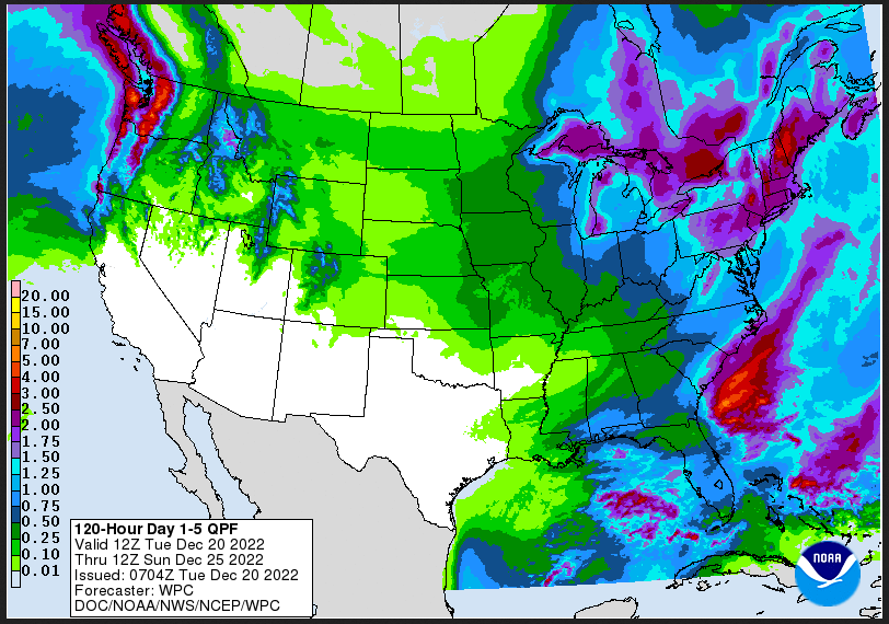
Days 1 Through 5 and 6 – 10 (I update these graphics every two days – but the reader can get an update if they want but the situation usually does not change that quickly)
| Days 1 – 5 (3 – 7 for Temperature) | Days 6 – 10 |
| https://www.wpc.ncep.noaa.gov/medr/medr_mean.shtml | https://www.cpc.ncep. noaa.gov/products/predictions/610day/ |
| These graphics update and can be clicked on to enlarge. You can see where the weather will be. An alternate website is https://www.wpc.ncep.noaa.gov/qpf/day1-7.shtml | |
–
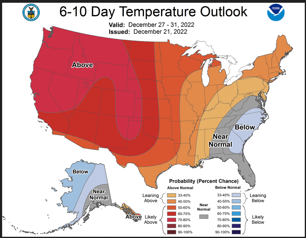
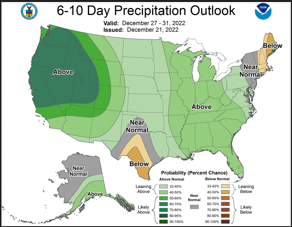
Days 6 – 10 Outlook
An outlook differs from a forecast based on how NOAA uses these terms in that an “outlook” presents information from deviation from normal and the likelihood of these deviations.
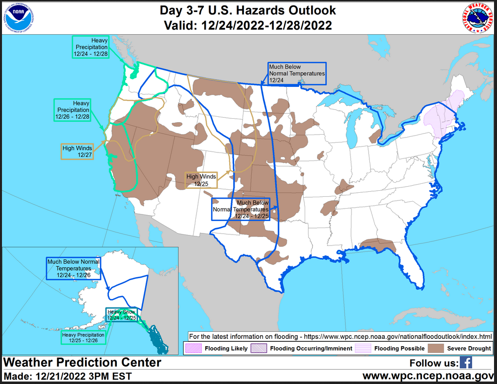
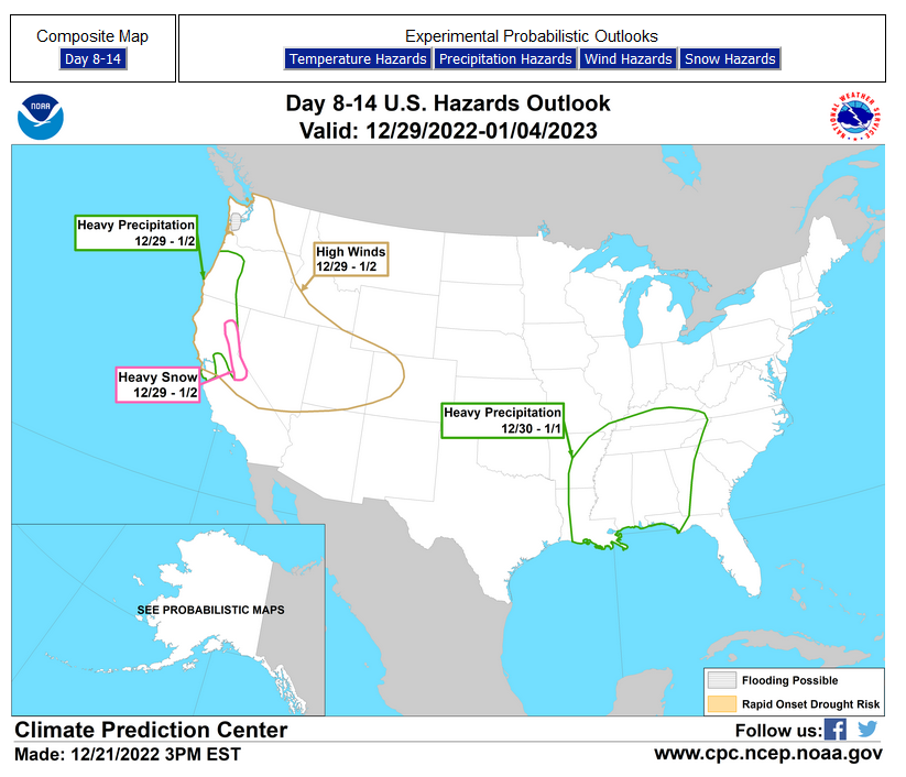
HAZARDS OUTLOOKS (I update these graphics every two days – but the reader can get an update if they want but the situation usually does not change that quickly)
Click here for the latest complete Day 3 -7 Hazards forecast which updates only on weekdays. Once a week probably Monday or Tuesday I will update the images. I provided the link for readers to get daily updates on weekdays. Use your own judgment to decide if you need to update these images.
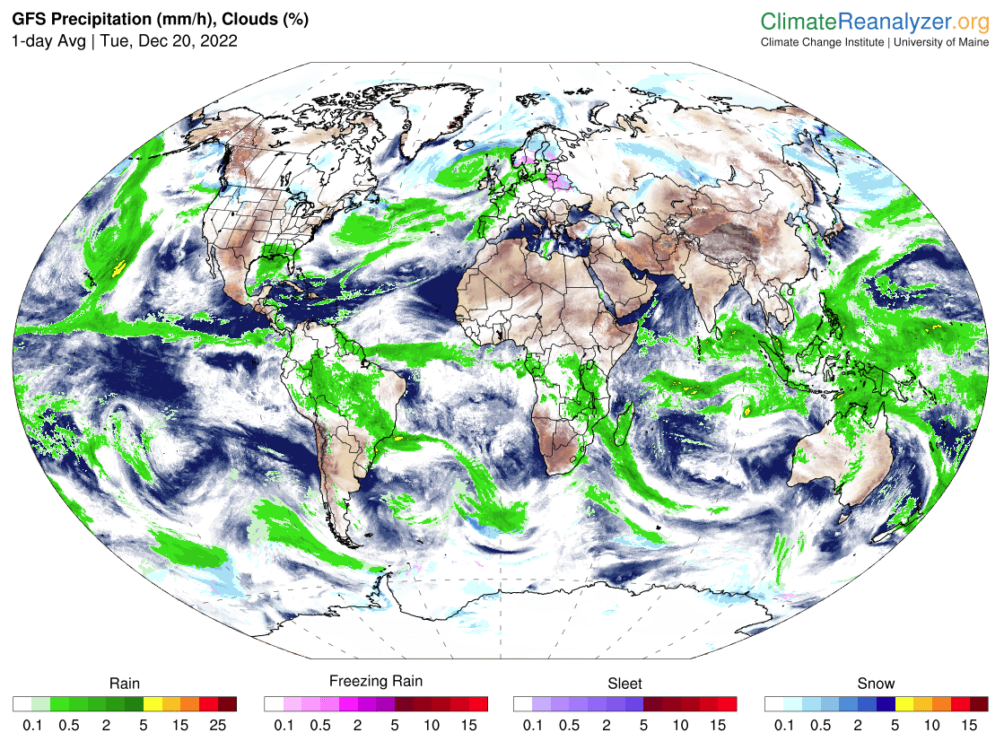
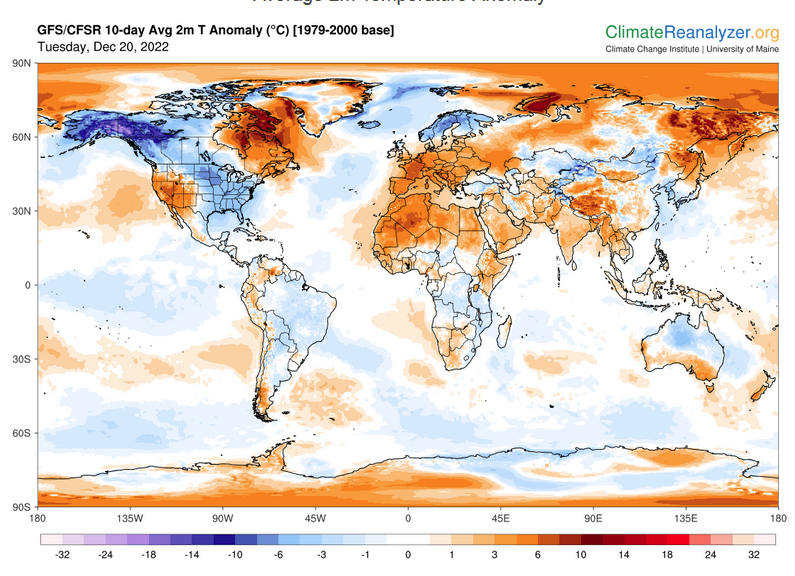
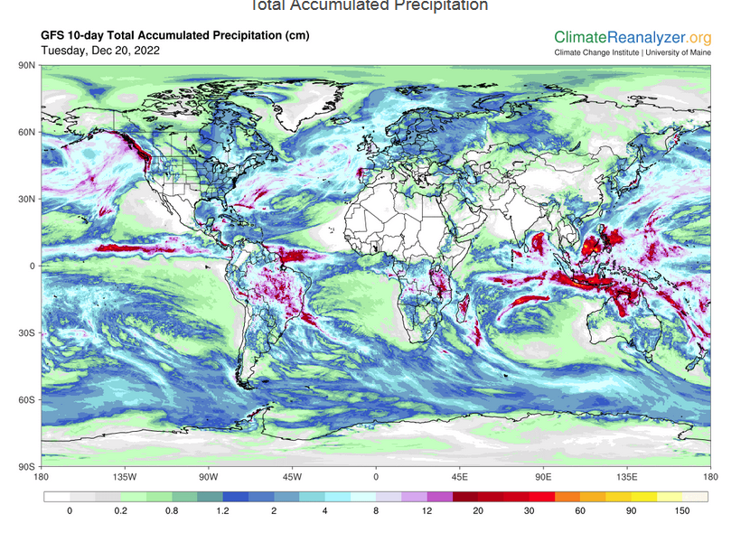
Worldwide Weather (The U.S. is part of the World so the U.S. forecast is included in these maps)
Below maps are the short-term forecast for precipitation and 10-day forecast for temperature and precipitation. I update the Day 1 Forecast daily and the ten-day forecasts every two days. A ten-day forecast is not likely to change much in 24 hours. But if you are looking at an out-of-date version of this article the current forecast maps can be obtained HERE.
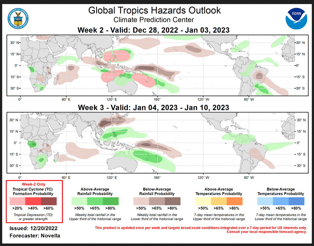
Worldwide Tropical Forecast
(This graphic updates on Tuesdays) If it has not been updated, you can get the update by clicking here This is a new approach and covers weeks 2 and 3 not weeks 1 and 2. It has more information but I am having trouble getting used to it. As usual, it comes with a discussion which is below
Detailed Maps and Reports for the Western Atlantic and the Pacific Oceans
Below are four maps that summarize the situation for the Atlantic, Eastern, Central Pacific, and Western Pacific. Additional information can be accessed by clicking HERE
First the Atlantic
Click to view the forecast map and have access to additional information https://www.nhc .noaa.gov/gtwo.php?basin= atlc&fdays=5
Then Eastern Pacific
Click to view the forecast map and have access to additional information https://www.nhc.noaa.gov/gtwo.php?basin=epac&fdays=5
Then Central Pacific
Click to view the forecast map and have access to additional information https://www.nhc.noaa.gov/gtwo.php?basin=cpac&fdays=5
And the Western Pacific
Click to view the forecast map and have access to additional information https://www.metoc.navy.mil/jtwc/jtwc.html
Some Longer U.S. Intermediate-Term Outlooks
Links to “Outlook” maps and discussions for Two time periods. Days 8 – 14, and Weeks 3 and 4.
You have to click on the links because they do not update automatically and I do not want to have stale images in the article. But it is not difficult to click on a link and you get a large image plus a discussion. On Fridays in a separate article, we will show the images and provide a link in this article that article. But remember what you will see is the images as of Friday. But here you can get the current images simply by clicking on them. Then hit the return arrow at the upper left of your screen to return to the article. You will not find this information easily anywhere else.
| Days 8 – 14 | Weeks 3 and 4 |
| https://www.cpc.ncep.noaa.gov/products/predictions/814day/ | https://www.cpc.ncep.noaa.gov/products/predictions/WK34/ |
| These graphics update and can be clicked on to enlarge. You can see where the weather will e | |
–
Month to Date Information
Month to date Temperature can be found at https://hprcc.unl.edu/products/maps/acis/MonthTDeptUS.png
Month to date Precipitation can be found at https://hprcc.unl.edu/products/maps/acis/MonthPNormUS.png