Here is what we are paying attention to this morning and the next 48 hours from this morning’s NWS Forecast.
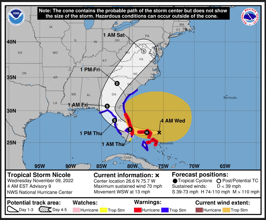
...Heavy mountain snow today for the Sierra Nevada, Intermountain West,
and northern Rockies...

...Major winter storm impacts possible for portions of the northern Plains
and Upper Mississippi Valley today through Thursday...

...Tropical Cyclone Nicole forecast to bring hurricane conditions to
portions of the Southeast coast and east-central Florida late today or
tonight...
Continuation of the NWS Short Range Forecast (It is updated twice a day and these updates can be found here.
Today, active weather is forecast once again across the West and will
spread into the northern High Plains as a low pressure system deepens over
the Great Basin and moves east. Precipitation associated with the system
will focus over the Sierra Nevada, Intermountain West, and northern
Rockies today, and heavy mountain snow will be possible at higher
elevations. Widespread Winter Storm Warnings and Winter Weather Advisories
are in effect for these areas. On the southern side of the system, gusty
winds, low humidity and dry fuels just west of a north-south oriented dry
line will combine to produce increased fire danger in eastern Colorado,
and the Storm Prediction Center has highlighted an area of Critical fire
weather conditions. Rapid wildfire spread will be possible, and those in
the affected area should listen to local officials for fire safety
information.

Late today into Thursday, wintry precipitation will spread into the
northern Plains and Upper Mississippi Valley as the system progresses. A
swath of heavy snow, and a corridor of sleet and freezing rain south of
the axis of heavy snow, are likely to impact these areas late today
through Friday. Significant snowfall accumulations will be possible in
some areas, and strong gusty winds combined with heavy snow could produce
blizzard conditions across the Dakotas. Winter Storm Watches are in effect
for much of the Dakotas and northern Minnesota. Some uncertainty remains
regarding the exact timing and location of the storm track, which could
significantly influence the expected impacts.

After bringing a taste of winter to the northern central U.S., the low
pressure center will track into Canada and pull a strong cold front
towards the eastern U.S. Cold, arctic air will filter in from the north
behind the system as high pressure builds over southern Canada and the
northern Rockies. Below normal temperatures will spread from west to east
through the week in the wake of the front, spreading over nearly the
entire CONUS this weekend. The coldest temperatures are expected to impact
portions on Montana today with highs in the teens and lows below zero.
Sub-freezing lows will be common across the West late this week through
the weekend.

Tropical cyclone Nicole continues to approach the Florida peninsula and is
forecast to strengthen to a hurricane before making landfall along the
Florida east coast. After landfall, the center of the storm is forecast to
track northwest across Florida before curving northeast and moving up
along the East Coast by this weekend. Tropical impacts and hazards will
spread far outside of the forecast cone produced by the National Hurricane
Center. Tropical Storm conditions are expected to begin early today for
much of Florida and coastal Georgia and Hurricane conditions are expected
for portions of the Southeast coast and east-central Florida beginning
late today or tonight. Tropical Storm Warnings and Hurricane Warnings are
in effect for these impact areas. Storm surge and damaging waves are
expected for coastal areas from south Florida to southern South Carolina
and could be particularly dangerous for in Florida and Georgia. Heavy
rainfall is expected today and Thursday across the Florida peninsula, and
flash flooding and river flooding, especially along the St. Johns River,
are likely. Heavy rainfall will spread northwards into the Southeast late
Thursday through Saturday. In addition to strong winds, surge, and heavy
rainfall, a few tornadoes will be possible in Florida today and eastern
Georgia and South Carolina Thursday. See nhc.noaa.gov for the latest
information regarding Nicole.
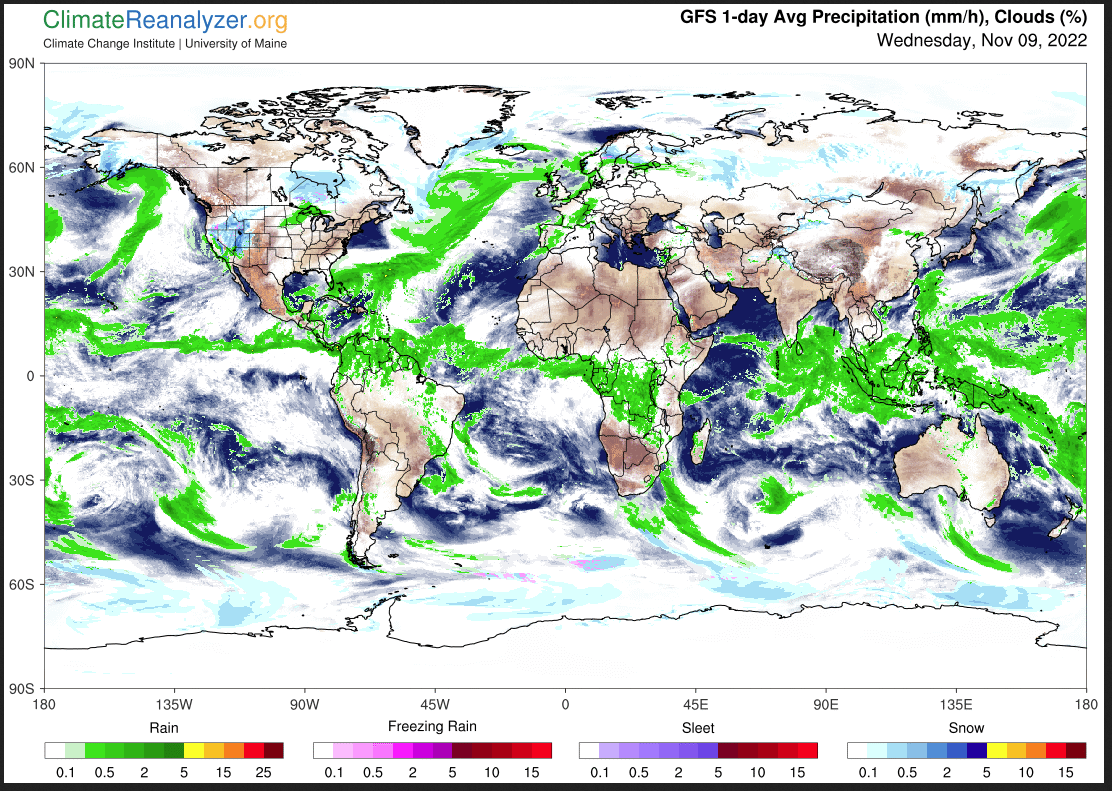
Current forecast of heavy precipitation (Updates can be found HERE)
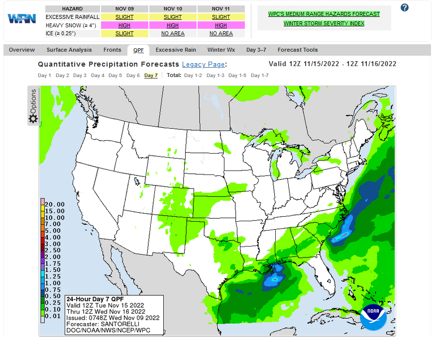
Maps that relate the forecast to geography can be found by clicking Here for Day 1 and Here for Day 2.
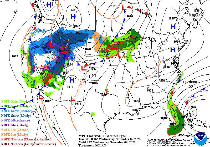
Here is a 60-hour animated forecast map that shows how the short-term forecast is expected to play out
If it needs to be updated click here.
ATMOSPHERIC RIVERS
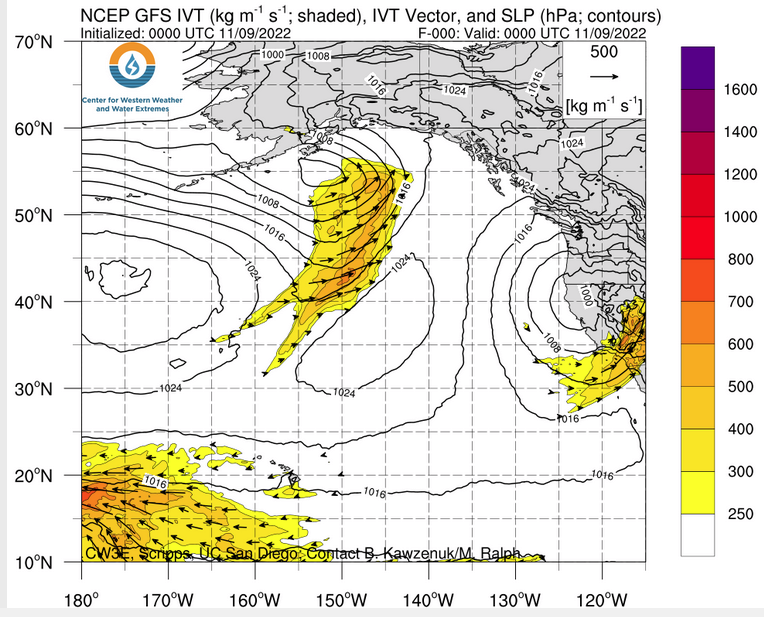
Click HERE to update. Here is some useful information about Atmospheric Rivers.
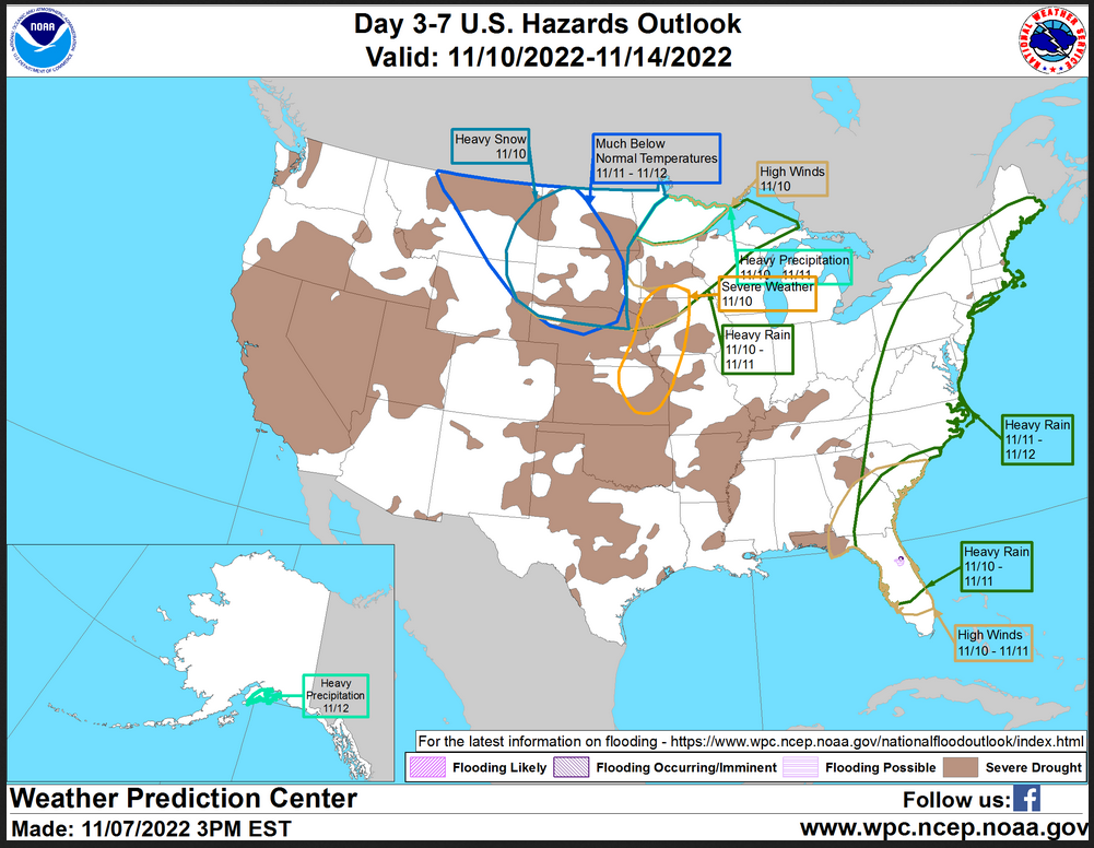
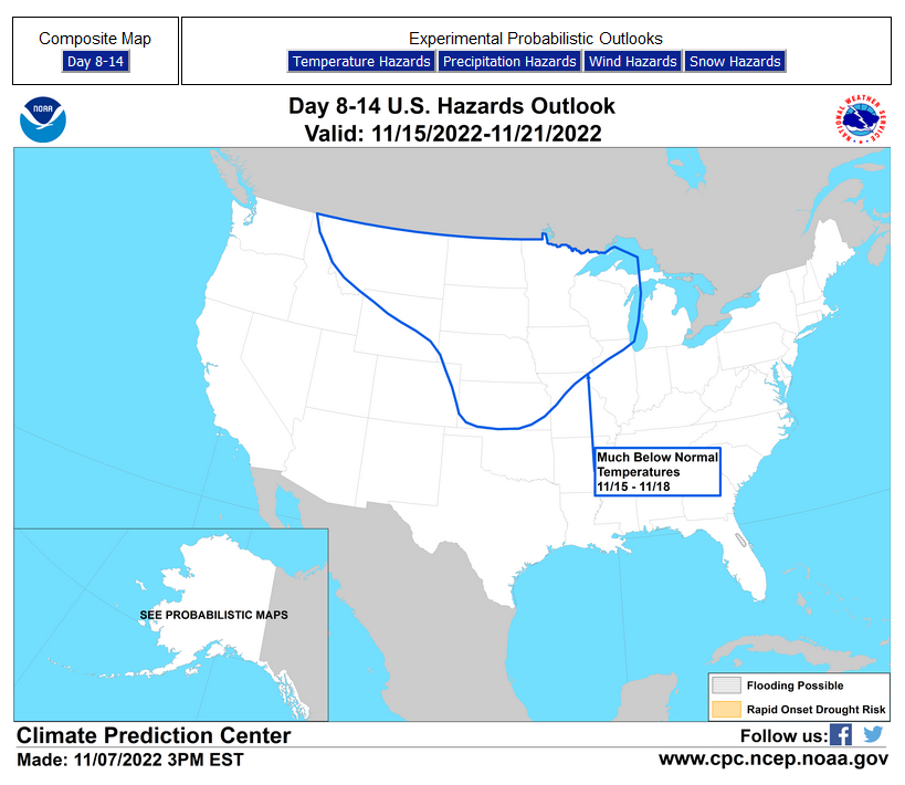
HAZARDS OUTLOOKS
Click here for the latest complete Day 3 -7 Hazards forecast which updates only on weekdays. Once a week probably Monday or Tuesday I will update the images. I provided the link for readers to get daily updates on weekdays. Use your own judgment to decide if you need to update these images.
Worldwide Tropical Forecast
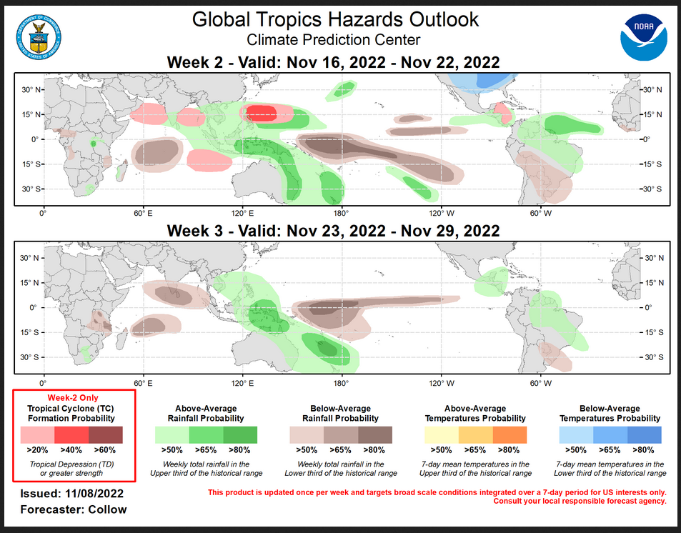
(This graphic updates on Tuesdays) If it has not been updated, you can get the update by clicking here This is a new approach and covers weeks 2 and 3 not weeks 1 and 2. It has more information but I am having trouble getting used to it. As usual, it comes with a discussion which is below
Detailed Maps and Reports for the Western Atlantic and the Pacific Oceans
Below are four maps that summarize the situation for the Atlantic, Eastern, Central Pacific, and Western Pacific. Additional information can be accessed by clicking HERE
First the Atlantic
Click to view the forecast map and have access to additional information https://www.nhc .noaa.gov/gtwo.php?basin= atlc&fdays=5
Then Eastern Pacific
Click to view the forecast map and have access to additional information https://www.nhc.noaa.gov/gtwo.php?basin=epac&fdays=5
Then Central Pacific
Click to view the forecast map and have access to additional information https://www.nhc.noaa.gov/gtwo.php?basin=cpac&fdays=5
And the Western Pacific
Click to view the forecast map and have access to additional information https://www.metoc.navy.mil/jtwc/jtwc.html
Some Intermediate-Term Outlooks
Links to “Outlook” maps and discussions for three time periods. Days 6 – 10, Days 8 – 14, and Weeks 3 and 4. An outlook differs from a forecast based on how NOAA uses these terms in that an “outlook” presents information from deviation from normal and the likelihood of these deviations.
You have to click on the links because they do not update automatically and I do not want to have stale images in the article. But it is not difficult to click on a link and you get a large image plus a discussion. On Fridays in a separate article, we will show the images and provide a link in this article that article. But remember what you will see is the images as of Friday. But here you can get the current images simply by clicking on them. Then hit the return arrow at the upper left of your screen to return to the article. You will not find this information easily anywhere else.

Right now you can find these maps here (We show them every Friday there but you can click above and find them).
Worldwide Weather
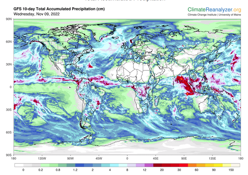
Below is the current or short-term precipitation forecast which can be updated by clicking HERE Additional maps can be obtained HERE.
 Month to Date Information
Month to date Temperature can be found at https://hprcc.unl.edu/products/maps/acis/MonthTDeptUS.png
Month to date Precipitation can be found at https://hprcc.unl.edu/products/maps/acis/MonthPNormUS.png