Here is what we are paying attention to this morning and the next 48 hours from this morning’s NWS Forecast.
...There is a Slight Risk of excessive rainfall over parts of the Central
Gulf Coast to The Southern Appalachians on Wednesday and expanding to the
southern Mid-Atlantic Coast on Thursday...

...There is a Slight Risk of severe thunderstorms over parts of the
Northern Rockies/High Plains through Thursday morning...

...Dangerous heat and humidity across parts of the South Plains to the
Lower Mississippi Valley will continue as well as parts of the Northern
High Plains and Great Basin...
Continuation of the NWS Short Range Forecast (It is updated twice a day and these updates can be found here.
Tropical moisture and upper-level energy will produce showers and
thunderstorms over parts of the Central Gulf Coast and the Southeast,
producing areas of heavy rain. Therefore, the WPC has issued a Slight Risk
of excessive rainfall over parts of the Central Gulf Coast, Tennessee
Valley, Southern Appalachians, and Southeast through Thursday morning. The
associated heavy rain will create mainly localized areas of flash
flooding, with urban areas, roads, and small streams the most vulnerable.
The excessive rainfall threat continues over the Central Gulf Coast to the Southeast on Thursday. The showers and thunderstorms remain over parts of the Central Gulf Coast and expand into the southern Mid-Atlantic with heavy rain. Therefore, the WPC has issued a Slight Risk of excessive rainfall over parts of the Central Gulf Coast, Southeast, and southern Mid-Atlantic on Thursday into Friday morning. The associated heavy rain will create mainly localized areas of flash flooding, with urban areas, roads, and small streams the most vulnerable. In addition, on both days, there is a risk of some thunderstorms becoming severe. Meanwhile, a front over the Pacific Northwest/Northern California will move eastward to the Northern Rockies/High Plains on Wednesday, producing showers and thunderstorms with some severe. Therefore, the SPC has issued a Slight Risk of severe thunderstorms over parts of the Northern Rockies/High Plains through Thursday morning. The hazards associated with these thunderstorms are frequent lightning, severe thunderstorm wind gusts, hail, and minimal risk of tornadoes. However, severe thunderstorm wind gusts can reach 65 knots or greater. On Thursday, the severe thunderstorm threat decreases slightly as the front moves eastward into the Northern Plains. Therefore, the SPC has issued a Marginal Risk of severe thunderstorms over parts of the Northern Plains and Middle Missouri Valley on Thursday into Friday morning. The hazards associated with these thunderstorms are frequent lightning, severe thunderstorm wind gusts, hail, and minimal risk of tornadoes. Furthermore, monsoonal moisture will trigger diurnal showers and thunderstorms over parts of the Southwest/Great Basin and Central/Southern Rockies on Wednesday and Thursday. Therefore, the WPC has issued a Marginal Risk of excessive rainfall over the region through Friday morning. The associated heavy rain will create localized areas of flash flooding, affecting areas that experience rapid runoff with heavy rain. Additionally, upper-level high over the Four Corners Region begins to build Wednesday into Friday. High temperatures will climb into the upper 90s and 100s over the Southern Plains and parts of the Lower Mississippi Valley. The dew points will be in the upper 60s to mid-70s along the over parts of the area, which have prompted Heat Advisories over the region through Wednesday evening. In addition, a few locations will have record high low temperatures contributing to areas not cooling off overnight, which will also contribute to the effects of heat. Moreover, there will be Excessive Heat Warnings and Heat Advisories over parts of the Great Basin through Thursday, while Heat Advisories over parts of the Northern High Plains on Wednesday.
21 to 28 Day Forecast/Outlook (On Thursday it is a 22 day forecast and when the Week 3 – 4 Forecast Updates on Friday it becomes a 28 day forecast)

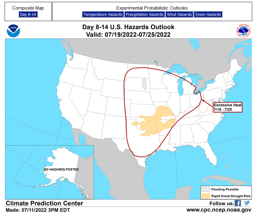
Links to “Outlook” maps and discussions for three time periods. Days 6 – 10, Days 8 – 14, and Weeks 3 and 4. An outlook differs from a forecast based on how NOAA uses these terms in that an “outlook” presents information from deviation from normal and the likelihood of these deviations.
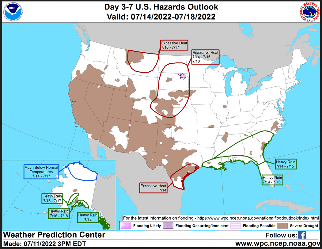
HAZARDS OUTLOOKS
Click here for the latest complete Day 3 -7 Hazards forecast which updates only on weekdays. Once a week probably Monday or Tuesday I will update the images. I provided the link for reads to get daily updates on weekdays. Use your own judgment to decide if you need to update these images.
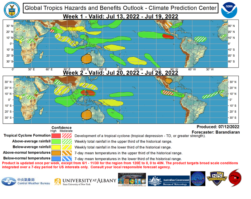
Worldwide Tropical Forecast
(This graphic updates on Tuesdays) If it has not been updated, you can get the update by clicking here https://www.cpc.ncep.noaa.gov/products/precip/CWlink/ghazards/images/gth_small.png
Detailed Maps and Reports for the Western Atlantic and the Pacific Oceans
Below are three maps that summarize the situation for the Atlantic, Eastern and Central Pacific. Additional information can be accessed by clicking HERE
First the Atlantic
Click to view the forecast map and have access to additional information https://www.nhc.noaa.gov/gtwo.php?basin=atlc&fdays=5
Then Eastern Pacific
Click to view the forecast map and have access to additional information https://www.nhc.noaa.gov/gtwo.php?basin=epac&fdays=5
Then Central Pacific
Click to view the forecast map and have access to additional information https://www.nhc.noaa.gov/gtwo.php?basin=cpac&fdays=5
And the Western Pacific
Click to view the forecast map and have access to additional information https://www.metoc.navy.mil/jtwc/jtwc.html
