Here is what we are paying attention to this evening and the next two days from this afternoon’s NWS Forecast.
...Oppressive to dangerous heat and humidity continues across the southern
Plains into the lower Mississippi Valley as some relief from the heat
moves into the central High Plains...

...Heat increases across the Desert Southwest and interior valleys of
California...

...Threat of heavy rain moving southward into the Southeast next couple of
days as another heavy rain threat emerges near the central Gulf Coast...

...Severe thunderstorms threat expected to track across the northern tier
states for the next couple of days...
Continuation of the NWS Short Range Forecast (It is updated twice a day and these updates can be found here.
An upper-level high anchored over the southern Plains will continue to
sustain the ongoing heat wave across the region for the next couple of
days.  Farther east, the effect of high humidity will make the heat more
oppressive over the lower Mississippi Valley even though the temperatures
there are not expected to climb as high.  Heat indices are forecast to
once again peak above 110 degrees at many places during the afternoon on
Monday.  Slightly cooler air behind a cold front is forecast to work its
way down the central Plains during the next couple of days, bringing in
some welcome relief there through Tuesday.  However, the interior Desert
Southwest and interior valleys of California will see the heat increasing
in intensity, especially Monday afternoon, with actually temperatures
likely exceeding 115 degrees at the hottest locations in the desert.

Meanwhile, waves of low pressure forming along a cold front will gradually
shift the threat of heavy rain southward into the Southeast for tonight
and early Monday.  By later on Monday into Tuesday, tropical moisture
gathering in the northern Gulf of Mexico will begin to interact with the
nearly stationary front where the threat of heavy rain is forecast to
increase near the central Gulf Coast by Tuesday.

In the meantime, upper-level energy and a weak front will track across the
northern tier states for the next couple of days.  Strong to severe
thunderstorms are possible near and ahead of the front.  The highest
threat of severe storms with locally heavy downpours is expected to be
across the northern Plains to the upper Midwest through tonight, shifting
east into the Midwest on Monday, and then into parts of the Northeast on
Tuesday.  The hazards associated with these thunderstorms are frequent
lightning, severe thunderstorm wind gusts, hail, and a few tornadoes.

Farther south, weak monsoonal moisture will trigger diurnal showers and
thunderstorms over parts of the Southwest, southern Rockies, and into
parts of the Central Rockies for the next couple of days.  On Monday into
Monday night, some of the moisture is forecast to interact with a front to
increase the threat of heavy rain over the High Plains of southern
Colorado into northern New Mexico.
21 to 28 Day Forecast/Outlook (On Thursday it is a 22 day forecast and when the Week 3 – 4 Forecast Updates on Friday it becomes a 28 day forecast)

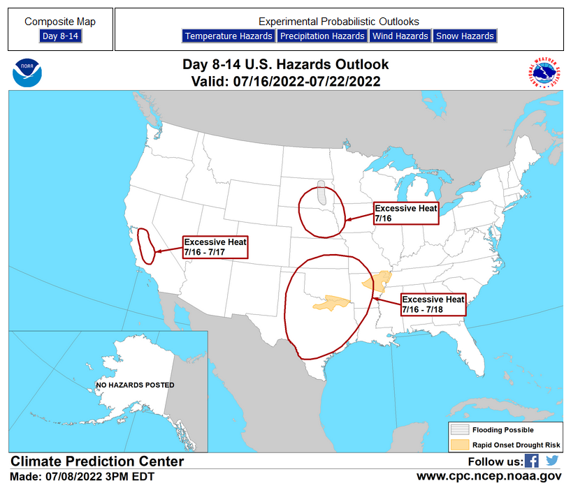
Links to “Outlook” maps and discussions for three time periods. Days 6 – 10, Days 8 – 14, and Weeks 3 and 4. An outlook differs from a forecast based on how NOAA uses these terms in that an “outlook” presents information from deviation from normal and the likelihood of these deviations.
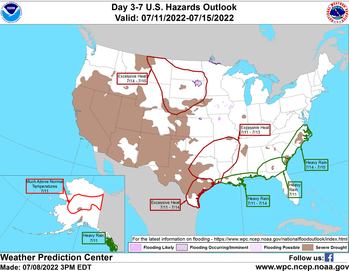
HAZARDS OUTLOOKS
Click here for the latest complete Day 3 -7 Hazards forecast which updates only on weekdays. Once a week probably Monday or Tuesday I will update the images. I provided the link for reads to get daily updates on weekdays. Use your own judgment to decide if you need to update these images.
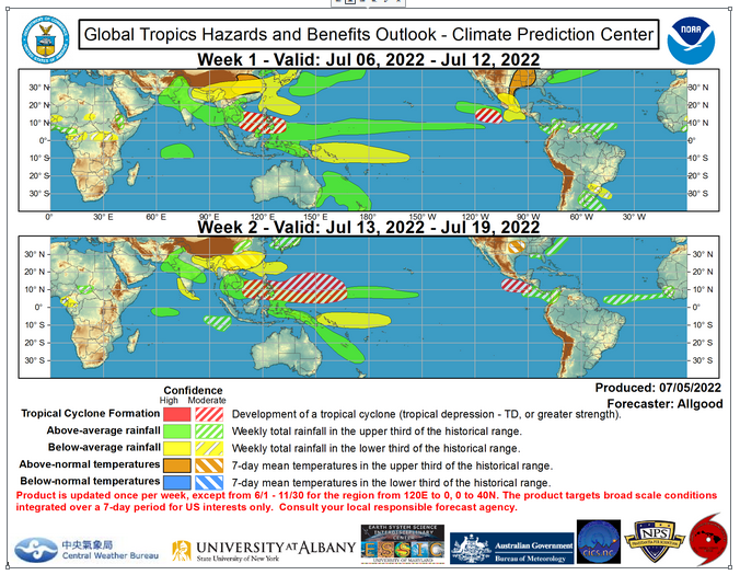
Worldwide Tropical Forecast
(This graphic updates on Tuesdays) If it has not been updated, you can get the update by clicking here https://www.cpc.ncep.noaa.gov/products/precip/CWlink/ghazards/images/gth_small.png
–
Detailed Maps and Reports for the Western Atlantic and the Pacific Oceans
Below are three maps that summarize the situation for the Atlantic, Eastern and Central Pacific. Additional information can be accessed by clicking HERE
First the Eastern Pacific
Click to view the forecast map and have access to additional information https://www.nhc.noaa.gov/gtwo.php?basin=atlc&fdays=5
Then Eastern Pacific
Click to view the forecast map and have access to additional information https://www.nhc.noaa.gov/gtwo.php?basin=epac&fdays=5
Then Central Pacific
Click to view the forecast map and have access to additional information https://www.nhc.noaa.gov/gtwo.php?basin=cpac&fdays=5
And the Western Pacific
Click to view the forecast map and have access to additional information https://www.metoc.navy.mil/jtwc/jtwc.html