 Introduction

Combination Early Outlook for April and Three-Month Outlook
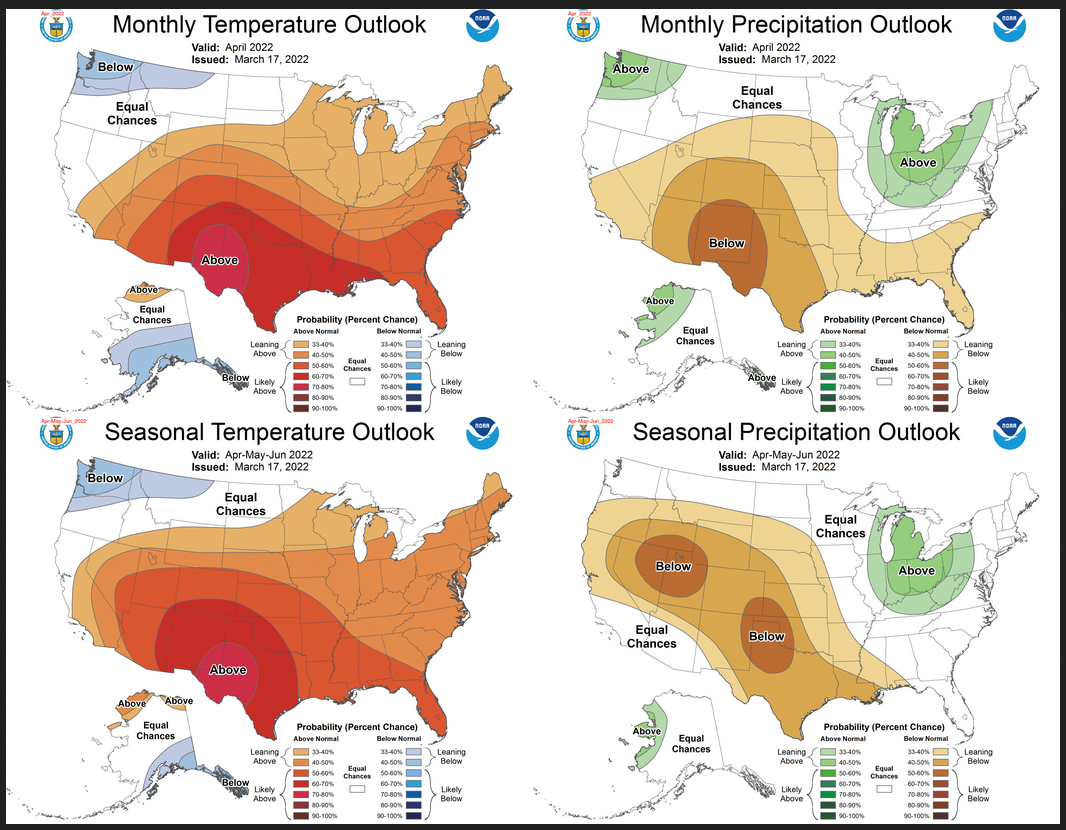
Notice that for temperature, the April and three-month outlook are similar. This suggests that the May/June outlook is also similar. But for precipitation, there is a bit more difference between the three-month and single month of April Outlook. This means that May/June will need to be a bit different than the April Outlook for the three months to average out to the three-month outlook.
| For both temperature and precipitation, if you assume the colors in the maps are assigned correctly, it is a simple algebra equation to solve the month two/three anomaly probability for a given location = (3XThree-Month Probability – Month One Probability)/2*. So you can derive the month two/three outlook this way. You can do that calculation easily for where you live or for the entire map. |
Here are larger versions of the Temperature and Precipitation outlook maps
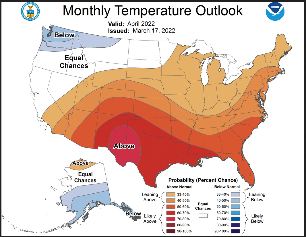
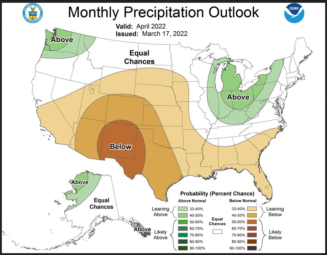
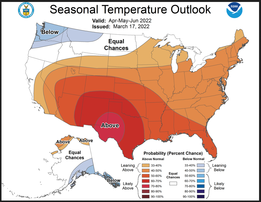
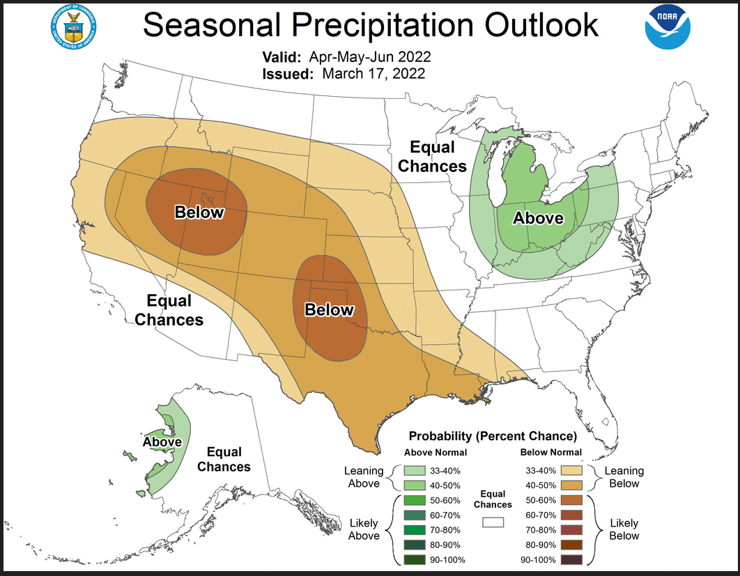
And here are large versions of the Seasonal Outlook maps starting with temperature followed by precipitation.
Drought Outlook
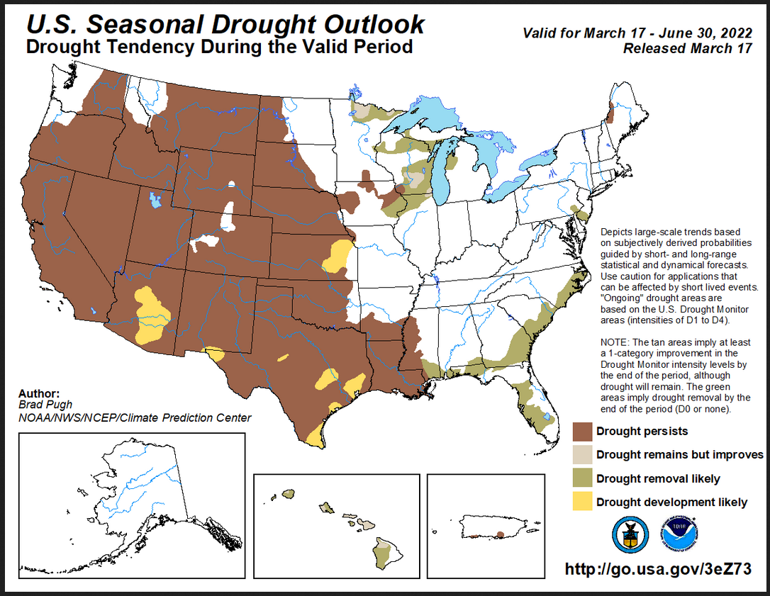
Looking out Four-Seasons.
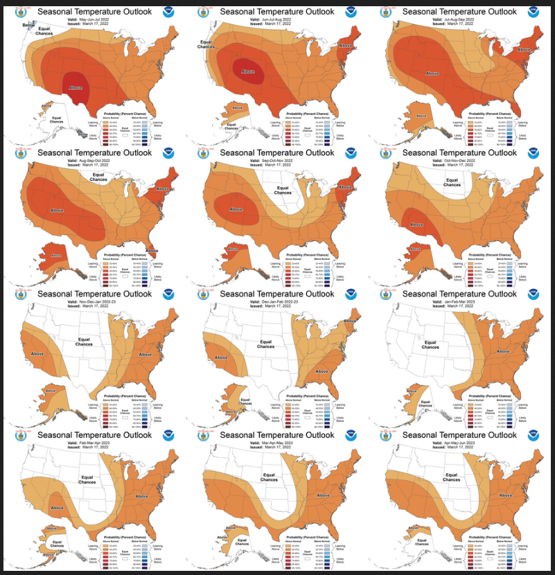
I am going to include the twelve Temperature maps now.
I am going to include the twelve Precipitation maps now.
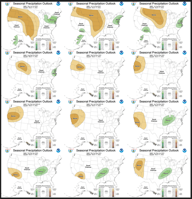
Similar to Temperature in terms of the organization of the twelve overlapping three-month outlooks.
North American Monsoon (NAM)
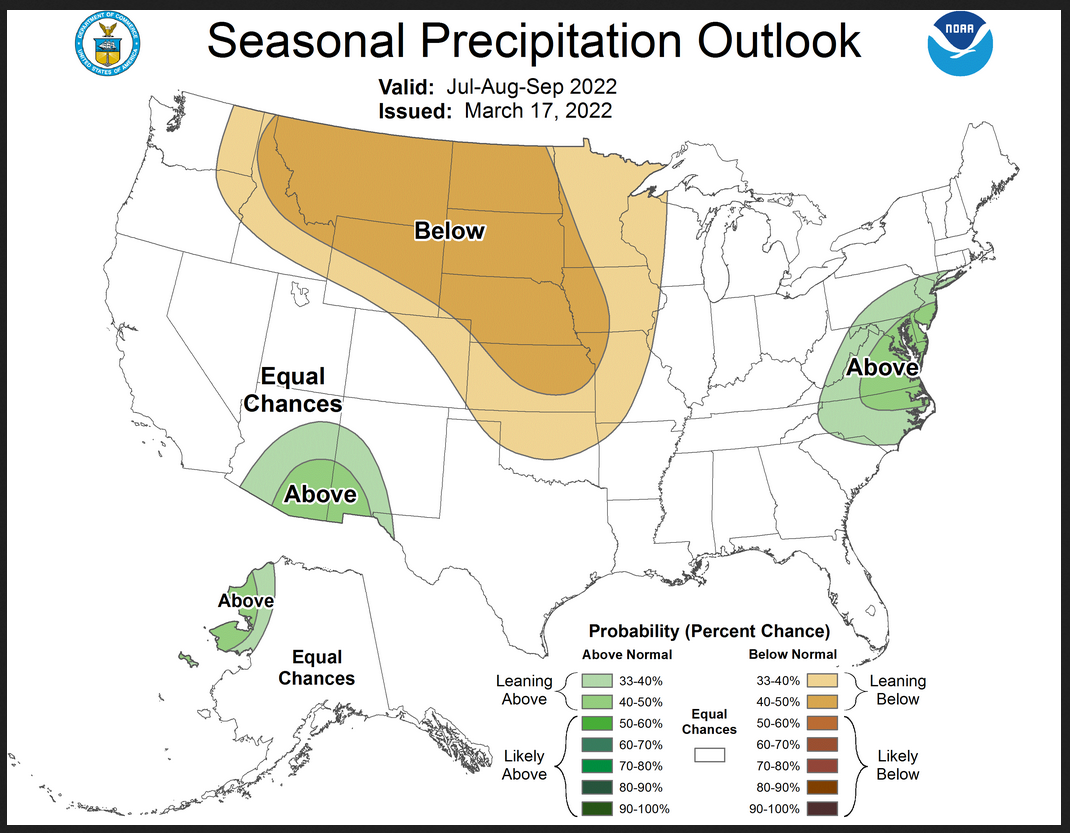
It is early to make a prediction for the NAM but NOAA has and the prediction is for an average Monsoon in general but better than average in the area shown in green. All things considered, it would appear that Arizona would benefit more than New Mexico and the impact to states north of Arizona and New Mexico would be normal except where the below normal precipitation is shown.
NOAA Discussion
Maps tell a story but to really understand what is going you need to read the discussion. I combine the 30-day discussion with the long-term discussion and rearrange it a bit and add a few additional titles (where they are not all caps the titles are my additions).
Let’s see if I have any comments to make. I think mostly I will use bold type to highlight some things that are important. My comments, if any, are enclosed in brackets [ ].
CURRENT ATMOSPHERIC AND OCEANIC CONDITIONS
La Niña conditions remain present in the equatorial Pacific Ocean as shown with both oceanic and atmospheric indicators. Equatorial sea surface temperatures (SSTs) anomalies continue to range from near 0.0 to less than -1.0 degree C from just west of the Date Line to the South America coast with a substantial area in the east-central Pacific less than -1.0 degree C. The most recent weekly value of the Nino3.4 SST index is -1.0 degree C. Ongoing and forecast MJO activity with the enhanced convective phase centered in the western Indian Ocean, however, is likely to modulate Pacific Ocean SSTs on a subseasonal time scale over the next few weeks at least via variations in low-level winds, solar radiation and precipitation. Below the surface, the 0 – 300 meter depth equatorial integrated heat content remains, to first order, near zero since mid-January 2022 (currently slightly negative).
Suppressed convection remains strong on both sides of the Date Line in the west-central Pacific Ocean, while enhanced convection continues across much of Indonesia and the Philippines. The recent monthly average of 850-hPa winds continue to show enhanced Trade winds compared with climatology in the central Pacific. Cyclonic circulations at 200-hPa symmetric about the equator also remain evident in the most recent monthly mean. The assessment of these ocean and atmospheric indicators show the coupled ocean-atmospheric system remains consistent with La Niña conditions.
PROGNOSTIC DISCUSSION OF SST FORECASTS
Forecasts of the Nino3.4 SST index from the NMME show considerable spread among the participant model ensemble means with the CFS being the greatest outlier – depicting continued negative Nino3.4 SST anomalies near -1.0 degrees C through the summer into the autumn months. The majority of the other participant models from both the NMME as well as the C3S systems trend toward ENSO-neutral (warmer than -0.5 degrees C) in the first half of the summer. Most guidance slightly hints at an initial decrease in Nino3.4 SSTs beginning in autumn indicating some potential for a return to La Niña during the winter of 2022-2023.
Statistical components of the CPC Nino3.4 SST consolidated forecast, however, favor a different solution and predict the development of El Niño conditions this coming winter. The official CPC ENSO outlook currently favors generally equal odds (40-50%) for either ENSO-neutral or La Niña during the Oct-Nov-Dec (OND) season.
30-DAY OUTLOOK DISCUSSION FOR APRIL 2022
The April 2022 Temperature and Precipitation Outlooks reflect current active La Niña conditions, the latest statistical and dynamical model guidance, impacts from decadal trend, antecedent soil moisture, current and likely snowpack, and sea surface temperature (SST) anomalies. Recent weekly NINO3.4 SST anomalies reached -1.0 degrees Celsius, and an extratropical response consistent with April La Niña events is anticipated. Impacts from La Niña are expected to be strongest over the Pacific Northwest and parts of Alaska based on correlation and regression analysis of past La Niña events. An emerging Madden Julian Oscillation (MJO) event is forecast through the end of March but further evolution of the MJO is uncertain in early April, thus the MJO did not play a strong role in the April 2022 outlook.
Temperature
Elevated probabilities of above normal monthly mean April temperatures stretch from the southern coast of California to the Northeast. Probabilities of above normal temperatures exceed 70% over the Southern High Plains where dynamical and statistical model guidance agreed and depicted highest confidence. Elevated probabilities of below normal temperatures are indicated for the Pacific Northwest eastward across parts of the Northern Rockies and Northern High Plains, consistent with dynamical model guidance from the North American Multi-Model Ensemble (NMME) and Copernicus Climate Change Service (C3S), as well as expected impacts from the active La Niña. Snowpack is lower than average in the Northern Plains, however, dynamical and statistical model guidance conflicted or favored equal chances (EC) of above and below normal temperatures over the region stretching from Northern California through parts of the Northern Plains, and so EC is depicted for these regions. Dynamical model guidance supports elevated probability of above normal temperatures over the Upper Mississippi Valley, Great Lakes, and Ohio Valley. However, surface moisture conditions are anomalously wet, thus probabilities of above normal temperatures are relatively weak (33 to 40 percent). Anomalously warm SST anomalies and decadal trends tilt the odds toward weak probabilities of above normal temperatures over the Northeast, despite uncertainty in statistical and dynamical model guidance.
Below normal temperatures are forecast for Southern Alaska including parts of the Aleutians reflecting consistent guidance from NMME and C3S, as well as anomalously cool coastal SSTs and expected impacts from the active La Niña. In contrast, above normal temperatures are favored over parts of the North Slope region of Alaska given positive decadal temperature trends and enhanced probabilities of above normal temperatures depicted by recent Climate Forecast System version 2 (CFSv2), NMME, and C3S guidance.
Precipitation
The April 2022 precipitation outlook considers statistical and dynamical models, antecedent soil moisture conditions, and La Niña impacts. Below normal precipitation is favored for the Southwest, most of the Plains, and Southeast. The highest probabilities of below normal precipitation (50 to 60 percent) are depicted over New Mexico and parts of western Texas given consistency between NMME and statistical models, and is consistent with the forecasted high probability of above normal temperatures over the region. Below normal precipitation in C3S guidance over southern California and parts of the Southwest tilt the odds toward weak probabilities of below normal precipitation (33 to 40 percent) where the NMME shows more uncertainty. Dynamical and statistical model guidance are at odds over Florida, where statistical model guidance favors above normal precipitation owing primarily to decadal trends , while the NMME, C3S, and CFSv2 favor below normal precipitation. Given model consistency, weak odds of below normal precipitation (33 to 40 percent) are favored over the Southeast. Forecasts are also mixed over the Great Lakes, though weak probabilities of above normal precipitation are shown in the NMME and CFSv2, and above normal precipitation is forecast in most of the models in the C3S. Dynamical model forecasts are supplemented by statistical forecasts based on soil moisture over the Great Lakes, and high anomalous soil moisture conditions in the upper and lower Great Lakes and Ohio Valley tilt the odds toward above normal precipitation. Elevated probabilities of above normal precipitation are forecast for the Pacific Northwest stretching northward into the Alaska panhandle, as well as the North Slope of Alaska, consistent with dynamical model guidance and expected La Niña impacts.
SUMMARY OF THE OUTLOOK FOR NON-TECHNICAL USERS (with a focus on AMJ 2022)
La Niña conditions remain in place across the equatorial Pacific Ocean as indicated by both oceanic and atmospheric conditions. La Niña is favored to continue into the Northern Hemisphere summer with generally equal odds for either La Niña or ENSO-neutral thereafter at about 40-50% likelihood. In addition to the forecast ENSO evolution, current anomalous soil moisture and snow cover and depth along with numerical and statistical model output inform the seasonal temperature and precipitation outlooks.
Temperature
The April-May-June (AMJ) 2022 temperature outlook favors above-normal seasonal mean temperatures for most of the contiguous U.S. and for the North Slope of Alaska. Below-normal temperatures are most likely for portions of the Pacific Northwest, northern Rockies and southeast Alaska including the Alaska Panhandle. Moreover, above-normal temperatures are most likely for nearly all of forecast domain as we move into and through the summer months.
Precipitation
The AMJ 2022 precipitation outlook favors above-normal seasonal total Precipitation amounts for portions of the Great Lakes, Ohio Valley, mid-Atlantic and Northeast as well as the west coast of Alaska. Below-normal precipitation is most likely for a region from the West coast across the Rockies to the central and southern Great Plains. The highlighted area of below-normal precipitation is forecast to shift north and east as the spring and summer months progress while above-normal precipitation is favored to shift eastward to the mid-Atlantic over the same period. Elevated odds for above-normal precipitation is introduced for parts of the Southwest during the monsoon seasons of Jun-Jul-Aug (JJA) and Jul-Aug-Sep (JAS).
Equal chances (EC) are indicated for areas where seasonal mean temperatures and seasonal total precipitation amounts are expected to be similar to climatological probabilities.
BASIS AND SUMMARY OF THE CURRENT LONG-LEAD OUTLOOKS
PROGNOSTIC TOOLS USED FOR U.S. TEMPERATURE AND PRECIPITATION OUTLOOKS
Given ongoing La Nina conditions and some atmospheric lag as Pacific SSTs slowly become less negative, as currently forecast, typical La Nina impacts are considered in preparing the AMJ, MJJ and JJA 2022 seasonal outlooks. ENSO composites and regressions anchored to the Nino3.4 SST index are utilized to inform the outlook in these seasons.
Current anomalous soil moisture and snow cover/depth are considered and contributed to the outlook in some locations during some seasons. Dynamical model forecasts from the NMME and C3S multi-model ensemble systems and the CA based on soil moisture anomalies are utilized heavily as was the objective, historical skill weighted consolidation – guidance that objectively combines both dynamical and statistical forecast tools. At later leads, long-term trends in temperature and precipitation are utilized heavily to inform the seasonal outlooks.
PROGNOSTIC DISCUSSION OF OUTLOOKS – AMJ 2022 TO AMJ 2023
TEMPERATURE
The AMJ 2022 temperature outlook favors above-normal seasonal mean temperatures for nearly all the contiguous U.S. and for the North Slope of Alaska. The greatest odds for above-normal temperatures is for the Southwest and southern Plains due to the combination of factors including overwhelmingly consistent dynamical model guidance, low soil moisture conditions, long-term positive temperature trends and other statistical forecast tools. Elevated odds for above-normal temperatures extend eastward to the Atlantic seaboard with lower probabilities when moving to the north and east with the lowest odds for parts of the Great Lakes and northern New England. Greater uncertainty, disagreement in forecast tools, lower historical forecast skill in forecast guidance and above-normal soil moisture (Ohio Valley, mid-South and parts of the Northeast) is the reason for these lower probabilities.
Consistent with ongoing La Niña conditions as indicated by ENSO composites, regressions and “bridging” tools (anchored to the Nino3.4 index), there are elevated chances for below-normal temperatures for southeast Alaska, the Alaska Panhandle and the Pacific Northwest. Negative trends in sea ice coverage and thickness and positive SST trends favor above-normal temperatures for some areas in northern Alaska.
Consistent signatures across the range of model guidance and statistical forecast tools including the CA based on soil moisture favor continued elevated odds for above-normal temperatures for most of the forecast domain through the ASO 2022 season with the greatest chances depicted for the western U.S. and for the Northeast and mid-Atlantic where long-term positive temperature trends play a role in the outlook.
Primarily beginning in OND 2022 and continuing through FMA 2023, the outlooks are largely based on long-term trends and depict a gradual increase in the coverage of the EC designation. Based on the uncertainty in the ENSO phase during the late autumn and winter months of 2022-2023 precluded any further adjustment of the outlooks at this time as this month’s outlook lies within the so called “spring predictability barrier” which leads to a minimum in forecast skill as a function of the seasonal cycle at longer forecast leads. If odds for La Nina re-development increase over the next couple of months, the inclusion of areas of favored below-normal temperatures may need to be considered for parts of the Pacific Northwest, northern Plains and southern Alaska in upcoming monthly forecast cycles.
PRECIPITATION
The AMJ 2022 precipitation outlook favors above-normal seasonal total precipitation amounts for portions of the Great Lakes, Ohio Valley, mid-Atlantic and Northeast primarily based on La Nina impacts, long-term positive precipitation trends and to a somewhat lesser degree dynamical model guidance from the NMME and C3S ensemble systems. There is considerably stronger agreement, however, for a region of favored below-normal precipitation from the central West coast to the Rockies to the central and southern Plains. La Niña considerations, overwhelming agreement in dynamical model guidance and in many areas the soil moisture based CA tool support this forecast.
The highlighted area of favored below-normal precipitation is forecast to slowly shift north and east during the late spring and summer months – consistent with dynamical model guidance and consistent with La Nina considerations. Moreover, the trend in the current dynamical model guidance from last month’s model predictions (NMME, C3S) for this favored below-normal precipitation area has been to increase it in areal coverage, odds (higher probabilities) and shift it northward and eastward to encompass more of the Plains and Mississippi Valley.
Above-normal precipitation is favored to shift eastward to the mid-Atlantic through ASO 2022 primarily related to long-term positive precipitation trends. Below-normal soil moisture and snowpack (in some areas) in the Southwest and southern Rockies may allow for more efficient heating of the land mass and so potentially an enhanced monsoon circulation earlier – all factors being equal. Along these lines, elevated odds for above-normal precipitation is forecast for parts of the southwest for JJA and JAS 2022. Forecasts from the ECMWF and GFDL dynamical model guidance and the soil moisture based CA statistical tool is the basis for this forecast.
La Nina considerations and dynamical model guidance favor above-normal precipitation for the west coast of Alaska from AMJ through JAS 2022. The outlooks from SON 2022 through AMJ 2023 are primarily supported and based on long-term precipitation trends .